Turnagain Pass RSS

Archives
ARCHIVED - Forecasts expire after 24 hours.
Issued
Wed, January 20th, 2021 - 7:00AM
Expires
Thu, January 21st, 2021 - 7:00AM
Forecaster
Wendy Wagner
Avalanche risk The Bottom Line

A CONSIDERABLE avalanche danger exists above 2,500′ where human triggered wind slabs are likely and cornice falls are a concern due to continued winds impacting the higher elevation terrain. A MODERATE danger exists below 2,500′ in exposed areas where winds are loading mid-elevation terrain. Watch for active wind loading and expect slabs to be in the 1-2′ thick range. Additionally, older larger slabs from Monday’s storm may still be possible to trigger on steep slopes, creating a much larger and dangerous avalanche on slopes above 1,500′.

SUMMIT LAKE: Wind slab avalanche are also expected in this area as Monday’s storm added around a foot of new snow. Due to this region having a thinner snowpack and multiple potential buried weak layers, extra caution is warranted for an avalanche breaking deeper in the pack.

Wed, January 20th, 2021
Alpine
Above 2,500'
3 - Considerable
Avalanche risk
Treeline
1,000'-2,500'
2 - Moderate
Avalanche risk
Below Treeline
Below 1,000'
2 - Moderate
Avalanche risk
0 - No Rating
1 - Low
2 - Moderate
3 - Considerable
4 - High
5 - Extreme
Avalanche risk Avalanche risk Avalanche risk Avalanche risk Avalanche risk
Travel Advice Generally safe avalanche conditions. Watch for unstable snow on isolated terrain features. Heightened avalanche conditions on specific terrain features. Evaluate snow and terrain carefully; identify features of concern. Dangerous avalanche conditions. Careful snowpack evaluation, cautious route-finding, and conservative decision-making essential. Very dangerous avalanche conditions. Travel in avalanche terrain not recommended. Extraordinarily dangerous avalanche conditions. Avoid all avalanche terrain.
Likelihood of Avalanches Natural and human-triggered avalanches unlikely. Natural avalanches unlikely; human-triggered avalanches possible. Natural avalanches possible; human-triggered avalanches likely. Natural avalanches likely; human-triggered avalanches very likely. Natural and human-triggered avalanches certain.
Avalanche Size and Distribution Small avalanches in isolated areas or extreme terrain. Small avalanches in specific areas; or large avalanches in isolated areas. Small avalanches in many areas; or large avalanches in specific areas; or very large avalanches in isolated areas. Large avalanches in many areas; or very large avalanches in specific areas. Very large avalanches in many areas.
Avalanche Problem 1
  • Wind Slabs
    Wind Slabs
  • Certain
    Very Likely
    Likely
    Possible
    Unlikely
    Likelihood
  • Historic (D4-5)
    Very Large (D3)
    Large (D2)
    Small (D1)
    Size
Wind Slabs
Wind Slab avalanches are the release of a cohesive layer of snow (a slab) formed by the wind. Wind typically transports snow from the upwind sides of terrain features and deposits snow on the downwind side. Wind slabs are often smooth and rounded and sometimes sound hollow, and can range from soft to hard. Wind slabs that form over a persistent weak layer (surface hoar, depth hoar, or near-surface facets) may be termed Persistent Slabs or may develop into Persistent Slabs.

Likelihood of Avalanches
Terms such as "unlikely", "likely", and "certain" are used to define the scale, with the chance of triggering or observing avalanches increasing as we move up the scale. For our purposes, "Unlikely" means that few avalanches could be triggered in avalanche terrain and natural avalanches are not expected. "Certain" means that humans will be able to trigger avalanches on many slopes, and natural avalanches are expected.

Size of Avalanches
Avalanche size is defined by the largest potential avalanche, or expected range of sizes related to the problem in question. Assigned size is a qualitative estimate based on the destructive classification system and requires specialists to estimate the harm avalanches may cause to hypothetical objects located in the avalanche track (AAA 2016, CAA 2014). Under this schema, "Small" avalanches are not large enough to bury humans and are relatively harmless unless they carry people over cliffs or through trees or rocks. Moving up the scale, avalanches become "Large" enough to bury, injure, or kill people. "Very Large" avalanches may bury or destroy vehicles or houses, and "Historic" avalanches are massive events capable of altering the landscape.

Signal Word Size (D scale) Simple Descriptor
Small 1 Unlikely to bury a person
Large 2 Can bury a person
Very Large 3 Can destroy a house
Historic 4 & 5 Can destroy part or all of a village
More info at Avalanche.org

After a brief break in weather yesterday, clouds and some light precipitation have moved in this morning. Only a couple inches of snow is expected today (at best and above 500′), but it will be the winds that are keeping the avalanche danger elevated. Ridgetop winds blew out of the east at the Sunburst weather station all night in the 25-30mph range with gusts in the 50’s. These winds are expected to remain through today and are plenty to push around the top foot or so of low density snow from Monday.

If you are headed out today, watch for any active or recent wind loading. This is most likely occurring in the higher terrain along ridgelines, but mid-elevations could be seeing impacts as well. Once again, looking for cracking around you in the top foot or more of snow, and any whumpfing, will be key for sussing out wind slabs. Not only are human triggered wind slabs likely, natural wind slabs and cornice falls are also possible.

Cornices? These are now very large and dangerous. Some cornices are close to 50-60′ wide along ridgelines. Be sure to give them an extra wide berth and know where you are on them. The cornice on top of the Seattle Ridge up-track is one of these monsters to watch out for.

Below 1,500′ the wet snowpack is trending toward a LOW hazard as it freezes. However, any low elevation slope that is still sporting wet snow, wet loose avalanches are possible.

In areas out of the wind, remember there is a stiff slab around 2′ thick sitting on a weaker storm snow interface. This interface, which was the low density snow from 1/15 and buried on 1/16, was the likely culprit in many of the natural avalanches that occurred on Monday. It would be too presumptuous to say this interface of weaker snow has completely bonded, and hence it could still be possible for a person to trigger a large slab that breaks 2′ or more below the surface.

Speaking of this interface, yesterday’s clear skies gave us a good sense of the widespread natural avalanche cycle that occurred during Monday’s storm. Many crowns 2-3′ thick (plus or minus) were visible along slopes and just under ridgelines. Additionally, significant cornice failures were also seen. Some highlight photos are below, but you can see many more on our observation page.

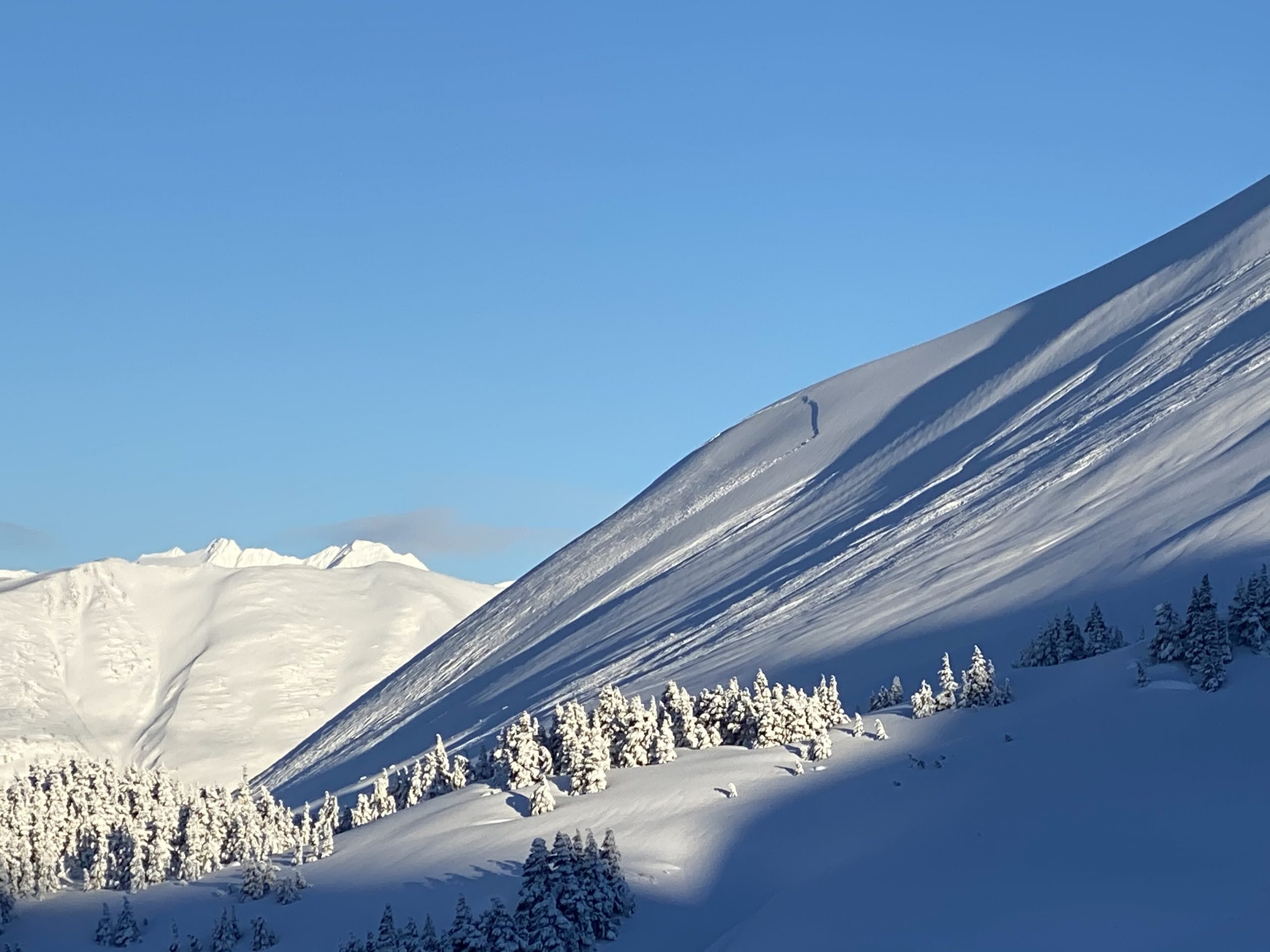
Warmup Bowl (-1 Bowl) on the backside of Seattle Ridge. Natural cornice fall and avalanche from 1.18.21, photographed 1.19.21. Photo: Beau Gehler.


Natural avalanche from 1.18.21 on the West face of Pyramid, also on the backside of Seattle Ridge. Photo taken 1.19.21 by Nick Olzenak.


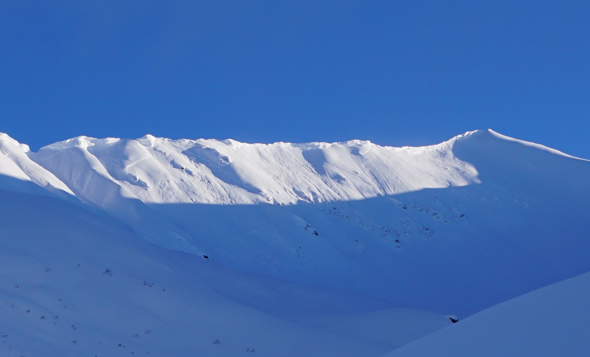
Sunburst SW face. Large natural avalanche from 1.18.21 that propagated across what appears to be the majority of the ridgeline. Photo from 1.19.21 by Thomas Bailly.


Magnum’s SW face. Many natural slab avalanches and cornice falls from 1.18.21. Photo from 1.19.21


*Big thanks to the many folks for passing along their photos yesterday!

Weather
Wed, January 20th, 2021

Yesterday: Mostly blue skies with some valley fog was over the region. Ridgetop winds were light from the west in the morning then switched back to easterly and have been increasing since the evening averaging near 30mph since midnight. Temperatures cooled a bit yesterday to 20F along the high ridgelines and 30F at the lower elevations.

Today: Cloudy skis with some light snow showers are expected above 500′ with light rain falling below. Ridgetop winds look to remain elevated, averaging 25-35mph from the east. Temperatures should climb slightly, to the mid 30’s at 1,000′ and mid 20’sF along the ridgelines.

Tomorrow: Another mostly cloudy day with a few snow showers adding an inch or two is expected for tomorrow. The rain/snow line again look to hover near 500′. Ridgetop winds are also expected to remain elevated through tomorrow from the east, blowing in the 25-35mph range.

PRECIPITATION 24-hour data (6am – 6am)

Temp Avg (F) Snow (in) Water (in) Snow Depth (in)
Center Ridge (1880′) 27 0 0 138
Summit Lake (1400′) 20 0 0 48
Alyeska Mid (1700′) 28 2 0.15 118

RIDGETOP 24-hour data (6am – 6am)

Temp Avg (F) Wind Dir Wind Avg (mph) Wind Gust (mph)
Sunburst (3812′) 21 NE 17 56
Seattle Ridge (2400′) 26 SE 14 32
Observations
Recent Observations for Turnagain Pass
Date Region Location
03/27/24 Turnagain Observation: Tincan Trees
03/26/24 Turnagain Observation: Cornbiscuit
03/25/24 Turnagain Observation: Tincan
03/22/24 Turnagain Avalanche: Magnum Northwest Aspect
03/21/24 Turnagain Observation: Sunburst
03/21/24 Turnagain Observation: Tincan Proper North Aspect
03/20/24 Turnagain Avalanche: Seattle Creek Drainage
03/19/24 Turnagain Observation: Tincan CFR
03/18/24 Turnagain Avalanche: Tincan – Eddies – Seattle Ridge
03/18/24 Turnagain Observation: Tincan
Riding Areas

The riding areas page has moved. Please click here & update your bookmarks.


Subscribe to Turnagain Pass
Avalanche Forecast by Email

This is a general backcountry avalanche advisory issued for Turnagain Arm with Turnagain Pass as the core advisory area. This advisory does not apply to highways, railroads or operating ski areas.