Turnagain Pass
|
![]() ![]() |
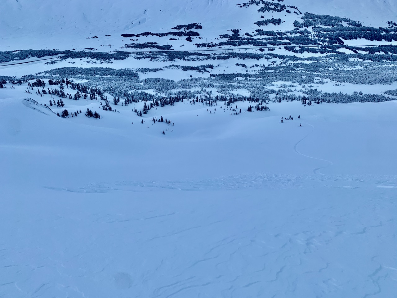
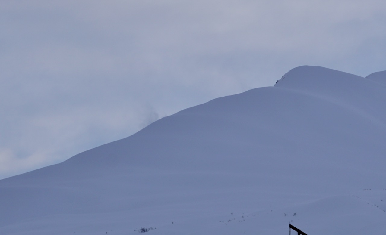
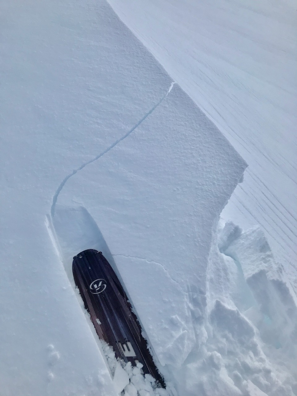
The avalanche danger is MODERATE above 1,000′ today. Triggering a wind slab remains possible on slopes 35° and steeper. These slabs could be 1-2′ deep and will be found near ridges on wind-loaded slopes and in cross-loaded gullies. Watch for active wind-loading, signs of wind effect and choose terrain carefully. Cornice falls are also a concern due to the continued winds impacting the higher elevation terrain. Additionally, there is still a chance of triggering an older larger slab from Monday’s storm on steep slopes, creating a more dangerous avalanche.
The avalanche danger is LOW below 1,000′ where there is a thick melt-freeze crust.
SUMMIT LAKE: Wind slab avalanches are also possible in this area. Due to this region having a thinner snowpack with buried weak layers, extra caution is warranted for the added potential of an avalanche breaking deeper in the snowpack.
SNUG/LOST LAKE/SEWARD: There was a snowmachiner caught and carried in an avalanche at Snug yesterday. We have limited information at this point and hope to get more details today. This area is out of our forecast zone and we have don’t have much data on the snowpack. If you do get out in the Central Kenai mountains, or around Seward, please share your observations here.
Heading to Hatcher Pass? Be sure to check the Thursday Conditions Summary at hpavalanche.org.
![]() |
![]() |
![]() |
![]() |
![]() |
|
Travel Advice | Generally safe avalanche conditions. Watch for unstable snow on isolated terrain features. | Heightened avalanche conditions on specific terrain features. Evaluate snow and terrain carefully; identify features of concern. | Dangerous avalanche conditions. Careful snowpack evaluation, cautious route-finding, and conservative decision-making essential. | Very dangerous avalanche conditions. Travel in avalanche terrain not recommended. | Extraordinarily dangerous avalanche conditions. Avoid all avalanche terrain. |
Likelihood of Avalanches | Natural and human-triggered avalanches unlikely. | Natural avalanches unlikely; human-triggered avalanches possible. | Natural avalanches possible; human-triggered avalanches likely. | Natural avalanches likely; human-triggered avalanches very likely. | Natural and human-triggered avalanches certain. |
Avalanche Size and Distribution | Small avalanches in isolated areas or extreme terrain. | Small avalanches in specific areas; or large avalanches in isolated areas. | Small avalanches in many areas; or large avalanches in specific areas; or very large avalanches in isolated areas. | Large avalanches in many areas; or very large avalanches in specific areas. | Very large avalanches in many areas. |
Signal Word | Size (D scale) | Simple Descriptor |
Small | 1 | Unlikely to bury a person |
Large | 2 | Can bury a person |
Very Large | 3 | Can destroy a house |
Historic | 4 & 5 | Can destroy part or all of a village |
With easterly ridgetop winds remaining elevated today, human triggered wind slabs will continue to be the concern. There is still soft snow to transport. Yesterday observers reported gusty ridgetop winds and blowing snow. There were two small skier triggered wind slabs that were 3-6″ deep. With additional wind-loading overnight and today the wind slabs could be 1-2′ deep. These will found in wind exposed terrain on steep unsupported slopes and cross-loaded gullies. You may be able to travel out onto the slab before it breaks above you, as is often the nature of hard wind slabs. Even a small slab can be very dangerous if you are in high consequence terrain. Looking for signs of wind effect and wind slab habitat will be key to safe travel today.
What to look for:
From Monday’s storm there is around 2′ of snow on a weaker storm snow interface. This interface, which was the low density snow from 1/15 and buried on 1/16, was the likely culprit in many of the natural avalanches that occurred on Monday. This interface is showing signs of bonding but a person triggering a large slab that breaks 2′ or more below the surface is still possible. Additional wind-loading may add stress and at this point it may be a situation where an avalanche fails with tracks already on the slope or if multiple people are on the slope at the same time. As always, practice safe travel protocols and expose only one person at a time.
Cornices: These are now very large and dangerous and there were a number of cornice falls during the storm on Monday. Some cornices are very wide along ridgelines and it is easy to not notice you are traveling out onto one. Be sure to give them an extra wide berth and know where you are in relation to them. They often break farther back than expected. The cornice at top of the Seattle Ridge up-track is one of these monsters to watch out for. Limit time spent underneath cornices as well. With continued wind-loading there is a chance one may fall naturally, which is dangerous on it’s own but could also trigger a wind slab on the slope below.
Yesterday: Skies were mostly cloudy trending to partly cloudy skies with very light rain/snow showers in the morning. Rain/snowline was around 300′. Winds were easterly 15-25 mph with gusts into the 30s and 40s and eased a bit in the afternoon. Temperatures were in the 20°Fs in the alpine and the mid 30°Fs at sea level. Overnight skies remained partly cloudy and temperatures were in the high 30°Fs at sea level and the mid 20°Fs at ridgetops. Winds were easterly 10-15 mph with gusts into the 20s and 30s.
Today: Skies will partly to mostly cloudy with snow and rain showers in the afternoon. Winds will be easterly 10-20 mph with gusts into the 30s. Temperatures will be in the mid 30°Fs at 1000′ and mid 20°Fs in the alpine. Temperatures cool slightly overnight and snow showers continue. Winds remain easterly 10-20 mph with gust into the 30s.
Tomorrow: Another day of mostly cloudy skies with snow and rain showers and east winds 10-20 mph gusting into the 30s. Temperatures will be similar to Thursday. Winds and precipitation look to increase overnight as a front pushes into the area.
PRECIPITATION 24-hour data (6am – 6am)
Temp Avg (F) | Snow (in) | Water (in) | Snow Depth (in) | |
---|---|---|---|---|
Center Ridge (1880′) | 31 | 0 | 0 | 134 |
Summit Lake (1400′) | 27 | 0 | 0 | 47 |
Alyeska Mid (1700′) | 31 | 0 | 0 | 134 |
RIDGETOP 24-hour data (6am – 6am)
Temp Avg (F) | Wind Dir | Wind Avg (mph) | Wind Gust (mph) | |
---|---|---|---|---|
Sunburst (3812′) | 21 | NE | 14 | 50 |
Seattle Ridge (2400′) | 25 | E | 10 | 23 |
Date | Region | Location | Observer |
---|---|---|---|
10/27/24 | Turnagain | Observation: Tincan | Michael Kerst |
10/21/24 | Turnagain | Observation: Turnagain Pass Road Observation | Trevor Clayton |
10/19/24 | Turnagain | Observation: Tincan – Below Todds Run | Andy Moderow |
10/18/24 | Turnagain | Observation: Taylor Pass | Eli Neuffer |
10/15/24 | Turnagain | Observation: Tincan Common | John Sykes Forecaster |
10/14/24 | Turnagain | Avalanche: Tincan | CNFAC Staff |
05/13/24 | Turnagain | Observation: Eddie’s, Sunburst, Seattle, Cornbiscuit, Pete’s South | H Thamm |
05/13/24 | Turnagain | Observation: Turnagain Pass non-motorized side | Amy Holman |
05/12/24 | Turnagain | Observation: Warm up Bowl | Tony Naciuk |
05/07/24 | Turnagain | Observation: Turnagain Pass Wet Slabs | A S |
The riding areas page has moved. Please click here & update your bookmarks.
Subscribe to Turnagain Pass
Avalanche Forecast by Email