Turnagain Pass RSS

Archives
ARCHIVED - Forecasts expire after 24 hours.
Issued
Tue, January 11th, 2022 - 7:00AM
Expires
Wed, January 12th, 2022 - 7:00AM
Forecaster
Andrew Schauer
Avalanche risk The Bottom Line

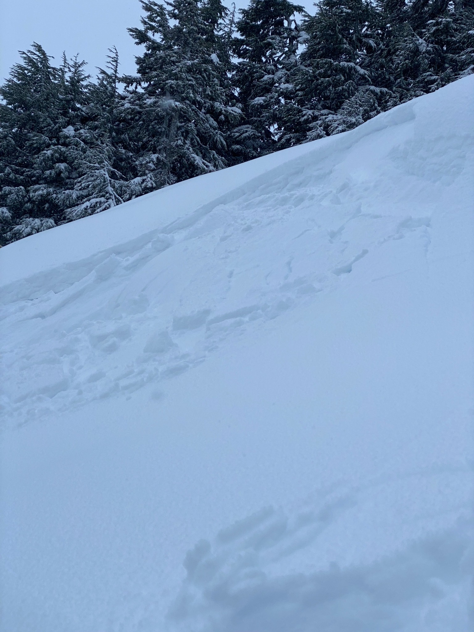
Today’s avalanche danger is CONSIDERABLE above 2500′, where yesterday’s heavy snowfall and strong winds have built sensitive slabs on top of weak snow surfaces. It is likely a person can trigger a large avalanche 1-3′ deep, and cautious route finding will be essential. This means avoiding traveling on or below steep slopes, especially just below ridgelines, on convex rollovers, or in wind-loaded gullies.

The danger is MODERATE below 2500′, where it will still be possible to trigger an avalanche 1-2′ deep breaking on weak snow below yesterday’s storm snow. Choose your terrain carefully, and be on the lookout for clear signs of poor stability like shooting cracks, collapsing, and fresh avalanche activity. With rain levels as high as 1500′ through last night, loose wet avalanches will be likely in the lower elevations.

*Roof Avalanches: Continued warm temperatures and rain will make roof avalanches likely today. Keep an eye on children and pets, and be careful where you park your vehicles.

Special Announcements
  • Tonight, 6:00 – 7:30pm:  Tune into our first Forecast Chat with John Sykes! He will be interviewing Pascal Haegeli on avalanche risk communication and ways to create a more effective avalanche forecast. Click the link above for more details and to register.
  • ALSO… just after the Forecaster Chat, the Friends group will be announcing the winners of the ‘Membership Giveaway’!! There are still a few days left to become a Friends member and enter to win a pair of skis, airbag pack, or a standby Heli-Ski day. Click HERE!
Tue, January 11th, 2022
Alpine
Above 2,500'
3 - Considerable
Avalanche risk
Treeline
1,000'-2,500'
2 - Moderate
Avalanche risk
Below Treeline
Below 1,000'
2 - Moderate
Avalanche risk
0 - No Rating
1 - Low
2 - Moderate
3 - Considerable
4 - High
5 - Extreme
Avalanche risk Avalanche risk Avalanche risk Avalanche risk Avalanche risk
Travel Advice Generally safe avalanche conditions. Watch for unstable snow on isolated terrain features. Heightened avalanche conditions on specific terrain features. Evaluate snow and terrain carefully; identify features of concern. Dangerous avalanche conditions. Careful snowpack evaluation, cautious route-finding, and conservative decision-making essential. Very dangerous avalanche conditions. Travel in avalanche terrain not recommended. Extraordinarily dangerous avalanche conditions. Avoid all avalanche terrain.
Likelihood of Avalanches Natural and human-triggered avalanches unlikely. Natural avalanches unlikely; human-triggered avalanches possible. Natural avalanches possible; human-triggered avalanches likely. Natural avalanches likely; human-triggered avalanches very likely. Natural and human-triggered avalanches certain.
Avalanche Size and Distribution Small avalanches in isolated areas or extreme terrain. Small avalanches in specific areas; or large avalanches in isolated areas. Small avalanches in many areas; or large avalanches in specific areas; or very large avalanches in isolated areas. Large avalanches in many areas; or very large avalanches in specific areas. Very large avalanches in many areas.
Recent Avalanches

Seward Highway/Portage Valley: Multiple natural avalanches were observed in the paths along the road near Girdwood and in the Portage Valley. Avalanches were running about 75% of the way to the valley bottom.

Seattle Ridge: Riders reported triggering multiple small storm slabs near the motorized uptrack. Nobody was caught in any of the slides.

Storm slab avalanche on a steep rollover near the Seattle Ridge uptrack. Photo submitted anonymously. 01.10.2022

Avalanche Problem 1
  • Wind Slabs
    Wind Slabs
  • Certain
    Very Likely
    Likely
    Possible
    Unlikely
    Likelihood
  • Historic (D4-5)
    Very Large (D3)
    Large (D2)
    Small (D1)
    Size
Wind Slabs
Wind Slab avalanches are the release of a cohesive layer of snow (a slab) formed by the wind. Wind typically transports snow from the upwind sides of terrain features and deposits snow on the downwind side. Wind slabs are often smooth and rounded and sometimes sound hollow, and can range from soft to hard. Wind slabs that form over a persistent weak layer (surface hoar, depth hoar, or near-surface facets) may be termed Persistent Slabs or may develop into Persistent Slabs.

Likelihood of Avalanches
Terms such as "unlikely", "likely", and "certain" are used to define the scale, with the chance of triggering or observing avalanches increasing as we move up the scale. For our purposes, "Unlikely" means that few avalanches could be triggered in avalanche terrain and natural avalanches are not expected. "Certain" means that humans will be able to trigger avalanches on many slopes, and natural avalanches are expected.

Size of Avalanches
Avalanche size is defined by the largest potential avalanche, or expected range of sizes related to the problem in question. Assigned size is a qualitative estimate based on the destructive classification system and requires specialists to estimate the harm avalanches may cause to hypothetical objects located in the avalanche track (AAA 2016, CAA 2014). Under this schema, "Small" avalanches are not large enough to bury humans and are relatively harmless unless they carry people over cliffs or through trees or rocks. Moving up the scale, avalanches become "Large" enough to bury, injure, or kill people. "Very Large" avalanches may bury or destroy vehicles or houses, and "Historic" avalanches are massive events capable of altering the landscape.

Signal Word Size (D scale) Simple Descriptor
Small 1 Unlikely to bury a person
Large 2 Can bury a person
Very Large 3 Can destroy a house
Historic 4 & 5 Can destroy part or all of a village
More info at Avalanche.org

The heavy snow and strong winds from yesterday have buried a variety of weak surfaces, which will keep avalanche danger elevated today. As of 6:00 this morning, storm totals are as follows:

  • Alyeska: 15-18″ snow equalling 1.5-2.1″ snow water equivalent (SWE)
  • Turnagain Pass: 10-12″ snow equalling 1.1″ SWE
  • Summit Lake: 3″ snow equalling 0.2″ SWE

Storm totals were higher in the Portage and Placer valleys. which likely recieved 18+” in the upper elevations. This snow came along with strong easterly winds through most of the day yesterday. The Sunburst weather station recorded sustained speeds of 20-50 mph with gusts of 35-70 mph through 6:00 p.m. Winds in the Girdwood area were slightly calmer at 15-20 mph before dropping down to around 10 mph at 11:00 a.m. yesterday. While we are expecting to see precipitation trickle off today, the problem we are left dealing with is that all of yesterday’s storm snow has buried a variety of weak surfaces that will remain reactive today. This includes a layer of near-surface facets that formed during the cold and clear weather in the first week of the year, pockets of buried surface hoar that formed just before this storm moved in, and the New Year’s rain crust that is buried anywhere from 1-3′ deep in the mid and upper elevations.

Since the  new snow is burying these persistent weak layers, we can expect to see sensitive avalanche conditions lingering a little bit longer than normal following this storm. The most likely place to trigger an avalanche will be on steep slopes that have been recently wind loaded. The most suspect locations will be above treeline, near ridgelines, below steep convexities, and in gullies. It may also be possible to trigger an avalanche up to a foot deep on steep slopes sheltered from the winds in the middle elevations. Traveling in the mountains today will require an extra alertness. Seek out feedback as you move around. Look for clear signs of poor stability like shooting cracks, collapsing, and fresh avalanche activity like John mentions in his video from the field below. The current snowpack will need more time to adjust, and today is not a good day to jump out into big terrain.

Loose Wet avalanches: Continued light rain up to 1200-1500′ as of 6:00 this morning will make it likely we will see some loose wet activity in the lower elevations. These avalanches will most likely be relatively small and slow moving, but they can have consequences if they push you into terrain traps like alders, trees, creeks, or rocks. As always, be sure to pay attention to the terrain above you so you don’t get caught off guard.

Shooting cracks at treeline in the Tincan trees yesterday. Since this storm fell on weak surfaces we can expect to see similar signs of poor stability lingering on some slopes today. Photo: Mike Loso. 1.10.2022.


Weather
Tue, January 11th, 2022

Yesterday: A warm and wet storm brought 10-12″ snow (1.1″ SWE) to Turnagain Pass, 15-18″ snow (1.49-2.09″ SWE) to Girdwood, and almost missed Summit Lake entirely, dropping only 1-2″ snow (0.2″ SWE). Strong easterly winds were blowing 20-50 mph, gusting 35-70 mph at Turnagain Pass until calming down around 6:00 p.m. Girdwood stayed slightly calmer at 15-20 mph with gusts of 30-60 mph before dropping to 5-15 mph with gusts around 15-30 mph since 11:00 a.m. yesterday. Temperatures have been in the upper 20’s to low 30’s F since yesterday morning. Mixed snow and rain has made it up to 1500′ in Girdwood and around 1300′ in Turnagain Pass.

Today: Light snow with rain to 1200′ is expected to subside this morning, with breaks in the clouds possible later this afternoon. We may see another 1-2″ snow before this round ends, with temperatures dropping in the mid 20’s F by the end of the day into tonight. The rain level is expected to drop back down to 500-600′, and light southeasterly winds are expected at 5-10 mph with gusts of 10-15 mph.

Tomorrow: Snow showers are expected to resume tonight, with another 2-5″ expected by the end of the day tomorrow. Right now it is looking like Turnagain Pass will be on the low end of that estimate and Girdwood will be on the upper end. Easterly winds are expected to pick up overnight into tomorrow at 15-30 mph under cloudy skies. Overnight low temperatures are looking to be in the low to mid 20’s, with daytime highs in the mid 20’s to low 30’s. Rain level is expected to stay around 300-800′.

PRECIPITATION 24-hour data (6am – 6am)

Temp Avg (F) Snow (in) Water (in) Snow Depth (in)
Center Ridge (1880′) 33 3 0.4 72
Summit Lake (1400′) 30 1 0.1 24
Alyeska Mid (1700′) 33 4 0.72 47

RIDGETOP 24-hour data (6am – 6am)

Temp Avg (F) Wind Dir Wind Avg (mph) Wind Gust (mph)
Sunburst (3812′) 25 ENE 17 60
Seattle Ridge (2400′) 28 SE 9 25
Observations
Recent Observations for Turnagain Pass
Date Region Location
03/28/24 Turnagain Observation: Sunburst
03/27/24 Turnagain Observation: Tincan Trees
03/26/24 Turnagain Observation: Cornbiscuit
03/25/24 Turnagain Observation: Tincan
03/22/24 Turnagain Avalanche: Magnum Northwest Aspect
03/21/24 Turnagain Observation: Sunburst
03/21/24 Turnagain Observation: Tincan Proper North Aspect
03/20/24 Turnagain Avalanche: Seattle Creek Drainage
03/19/24 Turnagain Observation: Tincan CFR
03/18/24 Turnagain Avalanche: Tincan – Eddies – Seattle Ridge
Riding Areas

The riding areas page has moved. Please click here & update your bookmarks.


Subscribe to Turnagain Pass
Avalanche Forecast by Email

This is a general backcountry avalanche advisory issued for Turnagain Arm with Turnagain Pass as the core advisory area. This advisory does not apply to highways, railroads or operating ski areas.