The avalanche danger is CONSIDERABLE today. Strong winds and up to a foot of new snow on top of weak surfaces will lead to dangerous avalanche conditions. It is likely a person could trigger a large avalanche 2′ deep or deeper and large natural avalanches will be possible. Cautious route finding will be essential today, which means avoiding traveling on or below steep slopes. Snow totals will be the heaviest in the Portage and Placer valleys, which will increase the likelihood of seeing larger natural and human-triggered avalanches.
*Roof Avalanches: Warm temperatures and rain at lower elevations will make roof avalanches a concern today. Keep an eye on children and pets, and be careful where you park your car.
Special Announcements
Tuesday, January 11th, 6 – 730pm: Tune into our first Forecast Chat with John Sykes! He will be interviewing Pascal Haegeli on avalanche risk communication and ways to create a more effective avalanche forecast. Click the link above for more details and to register.
ALSO… just after the Forecaster Chat, the Friends group will be announcing the winners of the ‘Membership Giveaway’!! There are still a few days left to become a Friends member and enter to win a pair of skis, airbag pack, or a standby Heli-Ski day. Click HERE!
Mon, January 10th, 2022
Alpine
Above 2,500'
3 - Considerable
Treeline
1,000'-2,500'
3 - Considerable
Below Treeline
Below 1,000'
3 - Considerable
0 - No Rating
1 - Low
2 - Moderate
3 - Considerable
4 - High
5 - Extreme
Travel Advice
Generally safe avalanche conditions. Watch for unstable snow on isolated terrain features.
Heightened avalanche conditions on specific terrain features. Evaluate snow and terrain carefully; identify features of concern.
Natural avalanches likely; human-triggered avalanches very likely.
Natural and human-triggered avalanches certain.
Avalanche Size and Distribution
Small avalanches in isolated areas or extreme terrain.
Small avalanches in specific areas; or large avalanches in isolated areas.
Small avalanches in many areas; or large avalanches in specific areas; or very large avalanches in isolated areas.
Large avalanches in many areas; or very large avalanches in specific areas.
Very large avalanches in many areas.
Avalanche Problem 1
Storm Slabs
Certain
Very Likely
Likely
Possible
Unlikely
Likelihood
Historic (D4-5)
Very Large (D3)
Large (D2)
Small (D1)
Size
Storm Slabs
Storm Slab avalanches are the release of a cohesive layer (a slab) of new snow that breaks within new snow or on the old snow surface. Storm-slabs typically last between a few hours and few days (following snowfall). Storm-slabs that form over a persistent weak layer (surface hoar, depth hoar, or near-surface facets) may be termed Persistent Slabs or may develop into Persistent Slabs.
Likelihood of Avalanches
Terms such as "unlikely", "likely", and "certain" are used to define the scale, with the chance of triggering or observing
avalanches increasing as we move up the scale. For our purposes, "Unlikely" means that few avalanches could be triggered in avalanche terrain and
natural avalanches are not expected. "Certain" means that humans will be able to trigger avalanches on many slopes, and natural avalanches are expected.
Size of Avalanches
Avalanche size is defined by the largest potential avalanche, or expected range of sizes related to the problem in question.
Assigned size is a qualitative estimate based on the destructive classification system and requires specialists to estimate the harm avalanches may cause to
hypothetical objects located in the avalanche track (AAA 2016, CAA 2014). Under this schema, "Small" avalanches are not large enough to bury humans and are
relatively harmless unless they carry people over cliffs or through trees or rocks. Moving up the scale, avalanches become "Large" enough to bury, injure,
or kill people. "Very Large" avalanches may bury or destroy vehicles or houses, and "Historic" avalanches are massive events capable of altering the landscape.
The avalanche danger is rising as snow continues to fall across the advisory area. As of 5:00 this morning, weather stations are showing 7-9″ of new snow, and another 3-5″ is expected during the day. Strong easterly winds have been blowing 25-50 mph since yesterday evening, and the Sunburst weather station is recording gusts just under 80 mph. This weather system is hard at work loading snow on top of a variety of weak surfaces including surface hoar, near-surface facets, and the New Year’s crust. In addition to the strong winds and heavy snowfall, we are also seeing the temperatures rising into the low 30’s this morning. Those rising temperatures mean heavier wet snow is stacking up on top of cold, dry snow, creating an upside-down storm layer that will be very touchy. This is a dangerous setup, and it is likely a person will be able to trigger an avalanche 2′ deep or deeper by the middle of the day today. If this storm ends up producing more than is expected as of this morning, we will be flirting with HIGH DANGER by the end of the day. Pay attention to signs of increasing danger, especially for fresh avalanche activity as the storm continues.
While the biggest avalanches will be found on wind-loaded slopes, we are also expecting to see dangerous avalanche conditions in frequently traveled sheltered terrain (think about the steeper rollovers in the Tincan trees). If you plan on getting out today, conservative decision making will be key. It is likely avalanches may be triggered remotely from above, below, or adjacent to steep terrain. The New Year’s crust will make for a very smooth bed surface, which means avalanches are likely to run fast and far. Be mindful of the terrain above you, and be sure to avoid spending any time in runout zones below steeper slopes. This is the kind of day to play around in the flats and stay on very mellow slopes. Everyone is thrilled to finally get a good refresh, but the current setup is nothing to mess with.
Loose Snow Avalanches: Rain lines are expected to rise up to 1500′ this morning, which will most likely lead to wet loose avalanches on steep slopes in lower elevations. At higher, colder elevations, we can expect to see dry loose avalanches running fast on top of the New Year’s crust. These will have enough volume to carry a person, and can have severe consequences in terrain traps like trees, rocks, alders, and open creeks.
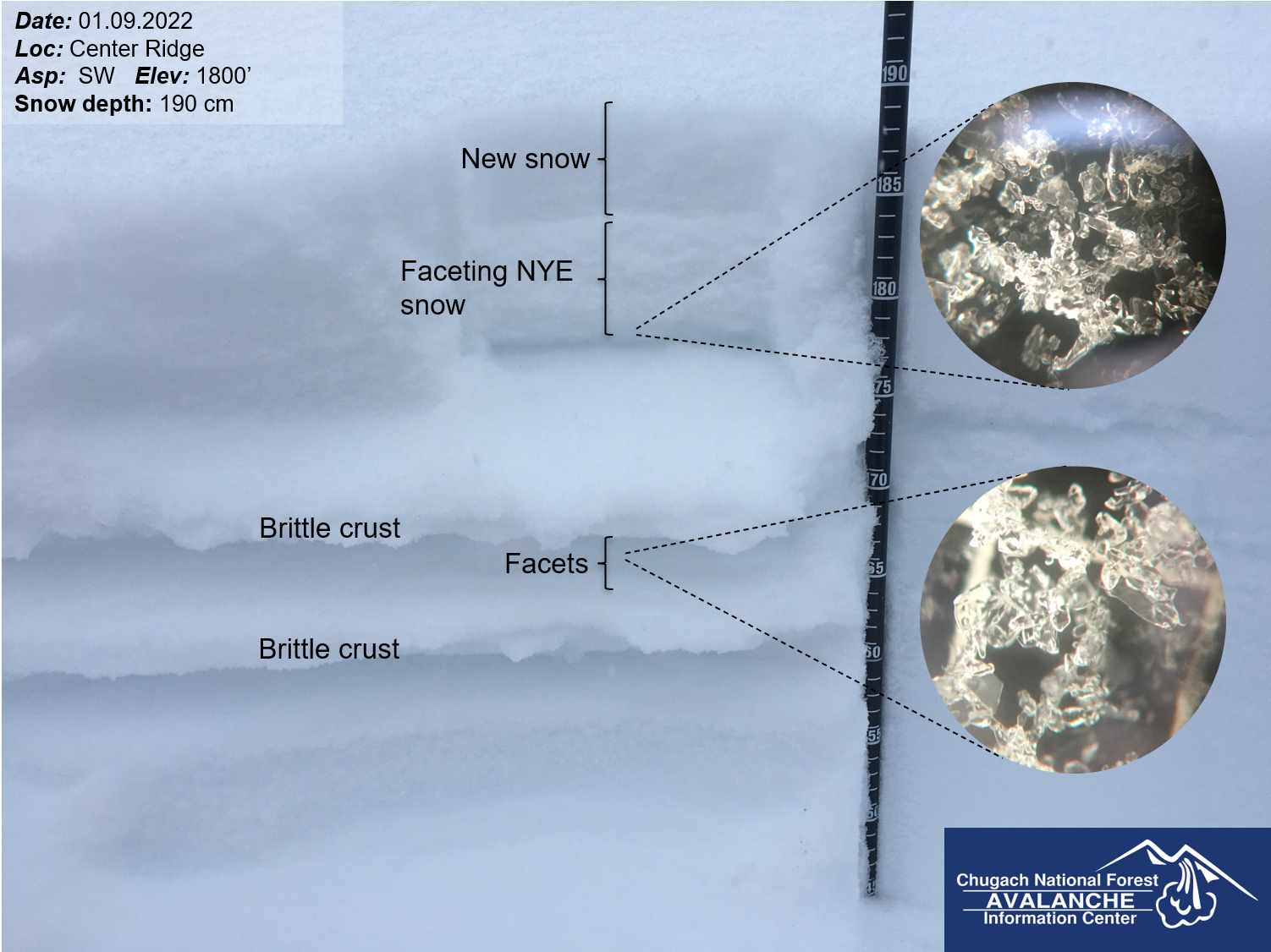
New snow is getting loaded on a variety of weak surfaces, including near-surface facets, buried surface hoar, and a nasty crust. Large avalanches are likely as the snow continues to stack up. Snow surface at 1800′ on Center Ridge, 01.09.2022.
Yesterday: Temperatures slowly climbed out of the single digits F during the day yesterday through last night, and are currently in the upper 20’s to low 30’s F. Light snowfall started picking up in the afternoon, with weather stations showing 7-9″ snow this morning. Easterly winds were blowing 5-10 mph for most of the day, with stronger winds picking up to 25-50 mph starting yesterday evening.
Today: Heavy snowfall is expected to taper off mid day, with another 3-5″ expected at Turnagain Pass and Girdwood, up to 10″ in Portage and Placer, and 1-3″ in Summit Lake. Strong easterly winds are blowing at 25-55 mph with gusts to 78 mph this morining, and are expected to slowly drop to 20-25 mph with gusts at 45-50 mph by late afternoon. The rain level is expected to rise up to around 1500′ this morning before dropping back down to 500-800′ later in the day. Temperatures are expected to stay in the upper 20’s to low 30’s F all day.
Tomorrow: The weather is expected to calm down tomorrow, with light snowfall bringing another 2-3″ overnight and a trace during the day tomorrow. Low temperatures will be in the mid to upper 20’s tonight, and will stay in the mid 20’s during the day tomorrow. Light easterly winds will stay around 5-10 mph under mostly cloudy skies.
This is a general backcountry avalanche advisory issued for Turnagain Arm with Turnagain Pass as the core advisory area.
This advisory does not apply to highways, railroads or operating ski areas.