Turnagain Pass Avalanche Forecast RSS

Archives
ARCHIVED FORECAST - All forecasts expire after 24 hours from the posting date/time.
Issued
Sun, January 9th, 2022 - 7:00AM
Expires
Mon, January 10th, 2022 - 7:00AM
Forecaster
John Sykes
Avalanche risk The Bottom Line

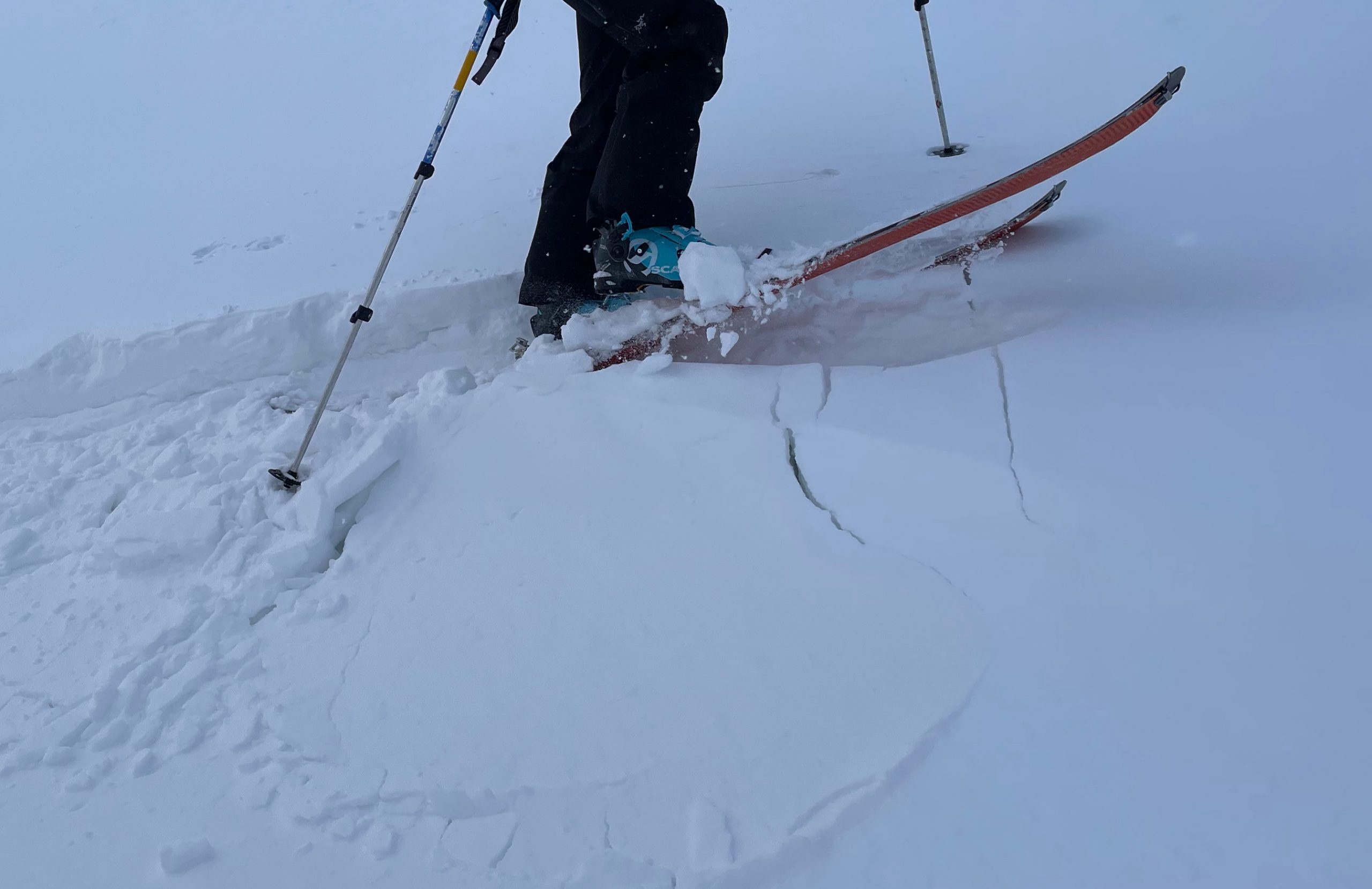
The avalanche danger will be MODERATE today above 1000′ during the daylight hours, but heavy snowfall and strong winds impacting the area starting this afternoon will be increasing the danger to CONSIDERABLE overnight. In the morning, before the snowfall and winds pick up, human triggered avalanches up to a foot deep will be possible in areas that saw active wind loading yesterday. Look for signs of snow transport on the surface and shooting cracks to identify areas with wind slabs that built up yesterday. Overnight, Human triggered avalanches 1+’ deep will be likely and natural avalanches will be possible in areas with active wind loading and significant accumulation of new snow.

The avalanche danger will be LOW below 1000′ today where triggering an avalanche is unlikely. Overnight the avalanche danger will rise to CONSIDERABLE with the onset of heavy precipitation and potential for a mix of snow and rain at lower elevations.

Special Announcements
  • Tuesday, January 11th, 6 – 730pm:  Tune into our first Forecast Chat with John Sykes! He will be interviewing Pascal Haegeli on avalanche risk communication and ways to create a more effective avalanche forecast. Click the link above for more details and to register.
  • ALSO… just after the Forecaster Chat, the Friends group will be announcing the winners of the ‘Membership Giveaway’!! There are still a few days left to become a Friends member and enter to win a pair of skis, airbag pack, or a standby Heli-Ski day. Click HERE
Thanks to our sponsors!
Sun, January 9th, 2022
Alpine
Above 2,500'
Moderate (2)
Avalanche risk
Treeline
1,000'-2,500'
Moderate (2)
Avalanche risk
Below Treeline
Below 1,000'
Low (1)
Avalanche risk
Alpine
Above 2,500'
Avalanche risk
Moderate (2)
Treeline
1,000'-2,500'
Avalanche risk
Moderate (2)
Below Treeline
Below 1,000'
Avalanche risk
Low (1)
Danger Scale:
No Rating (0)
Low (1)
Moderate (2)
Considerable (3)
High (4)
Extreme (5)
Avalanche Problem 1
  • Wind Slabs
    Wind Slabs
  • Almost Certain
    Very Likely
    Likely
    Possible
    Unlikely
    Likelihood
  • Historic (D4-5)
    Very Large (D3)
    Large (D2)
    Small (D1)
    Size
Wind Slabs
Wind Slab avalanches are the release of a cohesive layer of snow (a slab) formed by the wind. Wind typically transports snow from the upwind sides of terrain features and deposits snow on the downwind side. Wind slabs are often smooth and rounded and sometimes sound hollow, and can range from soft to hard. Wind slabs that form over a persistent weak layer (surface hoar, depth hoar, or near-surface facets) may be termed Persistent Slabs or may develop into Persistent Slabs.

Likelihood of Avalanches
Terms such as "unlikely", "likely", and "certain" are used to define the scale, with the chance of triggering or observing avalanches increasing as we move up the scale. For our purposes, "Unlikely" means that few avalanches could be triggered in avalanche terrain and natural avalanches are not expected. "Certain" means that humans will be able to trigger avalanches on many slopes, and natural avalanches are expected.

Size of Avalanches
Avalanche size is defined by the largest potential avalanche, or expected range of sizes related to the problem in question. Assigned size is a qualitative estimate based on the destructive classification system and requires specialists to estimate the harm avalanches may cause to hypothetical objects located in the avalanche track (AAA 2016, CAA 2014). Under this schema, "Small" avalanches are not large enough to bury humans and are relatively harmless unless they carry people over cliffs or through trees or rocks. Moving up the scale, avalanches become "Large" enough to bury, injure, or kill people. "Very Large" avalanches may bury or destroy vehicles or houses, and "Historic" avalanches are massive events capable of altering the landscape.

Signal Word Size (D scale) Simple Descriptor
Small 1 Unlikely to bury a person
Large 2 Can bury a person
Very Large 3 Can destroy a house
Historic 4 & 5 Can destroy part or all of a village
More info at Avalanche.org

A low pressure system will start impacting the forecast area this afternoon bringing moderate to heavy snowfall and increasing winds. The snowfall totals for this storm have come down a bit since yesterday but we still expect a significant new load with 18-24″ of new snow over a 24 hour period starting on Sunday afternoon. The timing of the new snowfall and winds will be the driving factor for how quickly the avalanche danger increases throughout the day. There is uncertainty in the weather forecast, but our best estimate is that significant snow accumulation will not happen until after daylight hours on Sunday.

The main concern for today are wind slabs up to a foot deep that formed yesterday and will continue to form today as we get additional snowfall and strong winds this afternoon. These fresh wind slabs will be possible for a person to trigger and could run farther than normal due to the New Years ice crust being buried just beneath the surface. With limited visibility today it could be hard to see if slopes above you are being actively wind loaded, so be aware of your position in the terrain relative to overhead hazards. Look for signs of recent snow transport on the surface, shooting cracks, and pillows of freshly loaded snow on leeward aspects to identify wind slabs.

Storm Slab Avalanches – As the new snow starts to accumulate this evening and overnight we will see a greater potential for storm slab avalanches at the interface between the new snow and the old snow surface. These could happen sooner if the timing of the snowfall is off, so be aware that if significant snowfall piles up throughout the day the avalanche danger will be rising quickly. We expect the new snow will not bond well to the 3-5″ of faceted snow and buried surface hoar that is on top of the New Years crust.

Small pocket of wind slab formed during the high winds yesterday in Summit Lake area. Photo from Aleph Johnston Bloom 1.8.22

Our current snow surface is not likely to bond well with the incoming storm snow, with buried surface hoar and near surface facets above the icy New Years crust. Photo Eeva Latosuo 1.8.22

Weather
Sun, January 9th, 2022

Yesterday: Overcast skies with light snowfall throughout the day in some areas and just brief periods of snow in other areas, accumulation up to 2″. Winds were moderate to strong at higher elevations with gusts into the upper thirties on Sunburst. Temperatures stayed well below freezing throughout the day, in the teens at lower elevations and single digits at upper elevations.

Today: A low pressure system will start to impact the area early this afternoon with moderate to heavy snowfall. Snow totals are on the order of 3-6″ before midnight on Sunday with another 3-6″ overnight on Monday. Total precipitation amounts could vary substantially across the forecast area with this storm, with higher snowfall totals in portage and placer. Temperatures should rise this evening with the snow line moving up to about 500-700′ overnight. Strong winds will accompany the snowfall with averages in the 5-25 range and gusts into the 50s possible overnight tonight.

Tomorrow: The snowfall should continue tomorrow with snow level rising throughout the day up to around 1000′ tomorrow evening. Total storm snowfall is estimated at 18-24″ by tomorrow evening. Winds will remain elevated tomorrow at 5-25 mph with gusts into the 40s and 50s. Additional smaller pulses of snowfall look to impact the area throughout the rest of this week.

PRECIPITATION 24-hour data (6am – 6am)

Temp Avg (F) Snow (in) Water (in) Snow Depth (in)
Center Ridge (1880′) 15 2 0.2 65
Summit Lake (1400′) 6 0.5 0.1 22
Alyeska Mid (1700′) 14 0 0.02 38

RIDGETOP 24-hour data (6am – 6am)

Temp Avg (F) Wind Dir Wind Avg (mph) Wind Gust (mph)
Sunburst (3812′) 6 E 16 39
Seattle Ridge (2400′) 10 E 7 22
Observations
Recent Observations for Turnagain Pass
Date Region Location
05/22/23 Turnagain Avalanche: Tincan
05/12/23 Turnagain Avalanche: Tincan, Sunburst, Magnum, Cornbiscuit
05/07/23 Turnagain Observation: Tincan – Bear Tracks
05/05/23 Turnagain Observation: Seattle Ridge
05/02/23 Turnagain Observation: Cornbiscuit
05/02/23 Turnagain Observation: Seward Hwy Turnagain Pass
04/30/23 Turnagain Observation: Magnum
04/29/23 Turnagain Observation: Tincan
04/28/23 Turnagain Avalanche: Taylor Pass/Pastoral
04/28/23 Turnagain Avalanche: Tincan
Riding Areas
Updated Thu, June 01st, 2023

Status of riding areas across the Chugach NF is managed by the Glacier and Seward Ranger Districts, not avalanche center staff. Riding area information is posted as a public service to our users and updated based on snow depth and snow density to prevent resource damage at trailhead locations. Riding area questions contact: mailroom_r10_chugach@fs.fed.us

Area Status Weather & Riding Conditions
Glacier District
Johnson Pass
Closed
Closed May 15.
Placer River
Closed
Closed May 15.
Skookum Drainage
Closed
Will close to motorized use on April 1, 2023 per the National Forest Plan.
Turnagain Pass
Closed
Will close on June 1.
Twentymile
Closed
Scheduled closure May 1.
Seward District
Carter Lake
Closed
Scheduled closure May 1.
Lost Lake Trail
Closed
Scheduled closure May 1.
Primrose Trail
Closed
Scheduled closure May 1.
Resurrection Pass Trail
Closed
Closed to motorized use for the 2022/23 winter season per Forest Plan. Open next season.
Snug Harbor
Closed
Extended opening until May 15.
South Fork Snow River Corridor
Closed
Scheduled closure May 1.
Summit Lake
Closed
Scheduled closure May 1.

Subscribe to Turnagain Pass
Avalanche Forecast by Email

This is a general backcountry avalanche advisory issued for Turnagain Arm with Turnagain Pass as the core advisory area. This advisory does not apply to highways, railroads or operating ski areas.