The avalanche danger is CONSIDERABLE above 2500′. There have been very large human-triggered avalanches two out of the past four days, breaking 3-6′ deep and very wide, connecting across very different terrain features. This unusually dangerous snowpack requires a cautious mindset, and the best bet is to stick to low-angle terrain. The danger is MODERATE between 1000′ and 2500′, where it is less likely a person will be able to trigger an avalanche, and LOW below 1000′.
Special Announcements
Join us at the Girdwood Brewing Co. from 5:30-7:00 p.m. on Thursday, Jan. 19 for the second Forecaster Chat of the season. CNFAIC forecaster Andrew Schauer will open the night with an overview of the state of the snowpack, followed by a discussion on how safe terrain management changes depending on the type of avalanche problem at hand. More details here.
Mon, January 9th, 2023
Alpine
Above 2,500'
3 - Considerable
Treeline
1,000'-2,500'
2 - Moderate
Below Treeline
Below 1,000'
1 - Low
0 - No Rating
1 - Low
2 - Moderate
3 - Considerable
4 - High
5 - Extreme
Travel Advice
Generally safe avalanche conditions. Watch for unstable snow on isolated terrain features.
Heightened avalanche conditions on specific terrain features. Evaluate snow and terrain carefully; identify features of concern.
Natural avalanches likely; human-triggered avalanches very likely.
Natural and human-triggered avalanches certain.
Avalanche Size and Distribution
Small avalanches in isolated areas or extreme terrain.
Small avalanches in specific areas; or large avalanches in isolated areas.
Small avalanches in many areas; or large avalanches in specific areas; or very large avalanches in isolated areas.
Large avalanches in many areas; or very large avalanches in specific areas.
Very large avalanches in many areas.
Recent Avalanches
After multiple very large human-triggered avalanches in two out of three days, we did not have any activity reported yesterday. Check out the observations for details on Thursday’s avalanches on Seattle ridge here and here,and Saturday’s very large avalanche on Cornbiscuit hereand here.
Avalanche Problem 1
Persistent Slabs
Aspect/Elevation
Certain
Very Likely
Likely
Possible
Unlikely
Likelihood
Historic (D4-5)
Very Large (D3)
Large (D2)
Small (D1)
Size
Persistent Slabs
Persistent Slab avalanches are the release of a cohesive layer of snow (a slab) in the middle to upper snowpack, when the bond to an underlying persistent weak layer breaks. Persistent layers include: surface hoar, depth hoar, near-surface facets, or faceted snow. Persistent weak layers can continue to produce avalanches for days, weeks or even months, making them especially dangerous and tricky. As additional snow and wind events build a thicker slab on top of the persistent weak layer, this avalanche problem may develop into a Deep Persistent Slab.
Aspect/Elevation of the Avalanche Problem
Specialists develop a graphic representation of the potential distribution of a particular avalanche problem across the topography.
This aspect/elevation rose is used to indicate where the particular avalanche problem is thought to exist on all elevation aspects.
Areas where the avalanche problem is thought to exist are colored grey, and it is less likely to be encountered in areas colored white.
Likelihood of Avalanches
Terms such as "unlikely", "likely", and "certain" are used to define the scale, with the chance of triggering or observing
avalanches increasing as we move up the scale. For our purposes, "Unlikely" means that few avalanches could be triggered in avalanche terrain and
natural avalanches are not expected. "Certain" means that humans will be able to trigger avalanches on many slopes, and natural avalanches are expected.
Size of Avalanches
Avalanche size is defined by the largest potential avalanche, or expected range of sizes related to the problem in question.
Assigned size is a qualitative estimate based on the destructive classification system and requires specialists to estimate the harm avalanches may cause to
hypothetical objects located in the avalanche track (AAA 2016, CAA 2014). Under this schema, "Small" avalanches are not large enough to bury humans and are
relatively harmless unless they carry people over cliffs or through trees or rocks. Moving up the scale, avalanches become "Large" enough to bury, injure,
or kill people. "Very Large" avalanches may bury or destroy vehicles or houses, and "Historic" avalanches are massive events capable of altering the landscape.
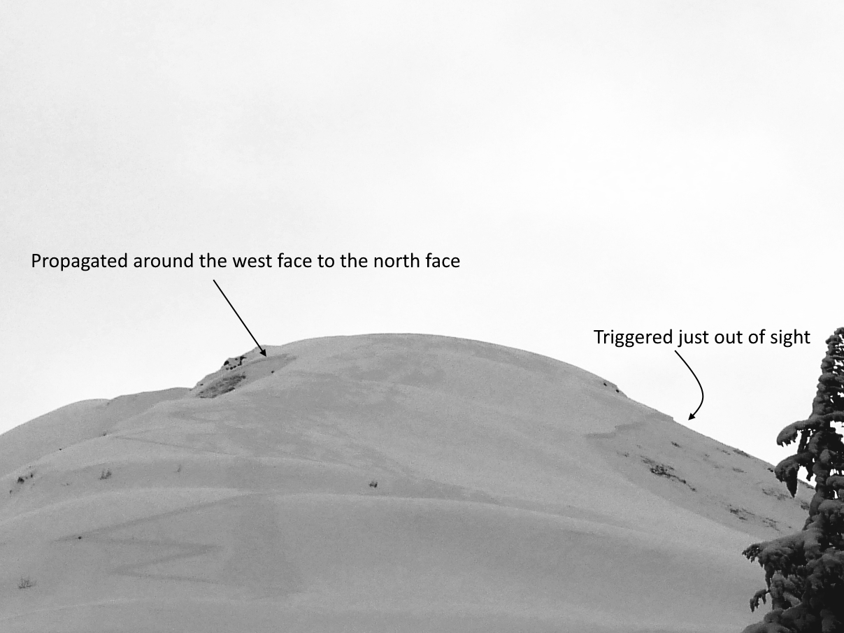
We are dealing with a dangerous snowpack that has shown its potential for making very large human-triggered avalanches. This includes several remote-triggered avalanches on Seattle Ridge on Thursday, and two very large avalanches on Cornbiscuit on Saturday. These avalanches are failing on a layer of facets associated with the Thanksgiving crust, now buried anywhere from 1.5 to 6′ deep or deeper, with an average depth of around 2-4′. That crust layer formed on all aspects, and has shown its potential for avalanches connecting across very different terrain features. The combination of this problematic setup being so widespread, deep, and so reactive to human triggers is a scary scenario.
In addition to the size and sensitivity of these avalanches, there are a few more things that make it especially dangerous and difficult (if not impossible) to manage. As seen from the avalanche on Cornbiscuit, the layer is deep enough that a person may need to find just the right spot to trigger an avalanche. This means there can be multiple sets of tracks on a slope without consequence before somebody triggers a big avalanche. The other thing that makes it challenging is that our typical travel tests won’t tell us anything about this layer. It is too deep to get any information from hand pits or test slopes, and it is pushing the limits of our standard stability tests (although I did have a column propagate a fracture and fall on my head while I was cutting an extended column test on Cornbiscuit yesterday).
With such unusual behavior and virtually no way to manage the problem in steep terrain, it’s time to take a big step back. For now the only way to stay out of trouble is to stick to low angle terrain.
Wind Slabs: Winds are slowly picking up, and will likely be strong enough to start building fresh wind slabs later in the day. These will be small today, but they will be forming on top of a new weak layer of surface hoar and facets, so we can bet they will be touchy. Keep an eye on changing conditions and increasing chances of triggering an avalanche near the surface if the winds pick up earlier in the day. A shallower avalanche triggered on the surface will have a greater chance of triggering a big avalanche deeper in the snowpack.
The fracture that connected these two avalanches propagated around 1500′, connecting south, west, and north-facing slopes. 01.08.2023.
Click here to view the video below if it doesn’t load in your browser.
Weather
Mon, January 9th, 2023
Yesterday: Skies were mostly cloudy, with increasing clouds through the day. Winds were light out of the east at around 5 mph with gusts of 15-20 mph, picking up slightly overnight. We picked up a trace to an inch of snow overnight, and temps climbed from the single digits below and above 0 F yesterday morning to the mid to upper 20’s F overnight.
Today: Skies will be partly to mostly cloudy, with some clearings through the day and improving visibility later in the day. Winds will be light out of the east at 5-15 mph gusting 10-25 mph, picking up later in the afternoon through tonight. No precipitation is expected today, with a trace overnight. High temperatures should be in the mid to upper 20’s F near Turnagain Pass and in the upper teens to low 20’s F near Girdwood.
Tomorrow: Winds should pick up again tonight, blowing 15-20 mph out of the east with gusts of 20-30 mph. Light snow showers should bring 3-5” snow, with snow down to 200-400’. The mountains around Seward could see over a foot of snow during the same time frame, with light snowfall starting tonight and continuing through Tuesday night. High temperatures will be in the mid to upper 20’s F, with lows dropping into the upper teens to low 20’s F. Skies will be mostly cloudy to overcast during the day.
This is a general backcountry avalanche advisory issued for Turnagain Arm with Turnagain Pass as the core advisory area.
This advisory does not apply to highways, railroads or operating ski areas.