Turnagain Pass RSS

Archives
ARCHIVED - Forecasts expire after 24 hours.
Issued
Sat, January 7th, 2023 - 7:00AM
Expires
Sun, January 8th, 2023 - 7:00AM
Forecaster
John Sykes
Avalanche risk The Bottom Line

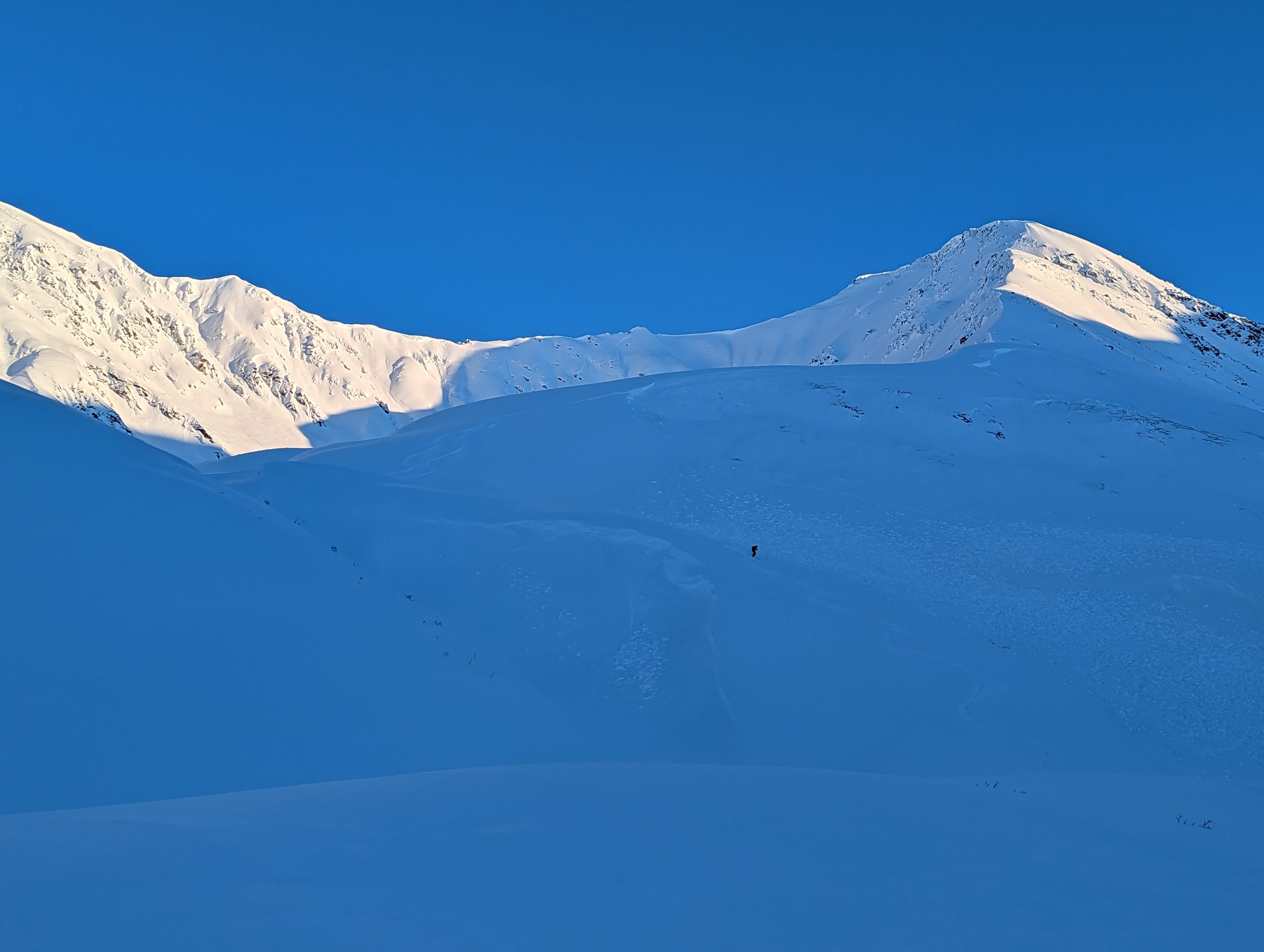
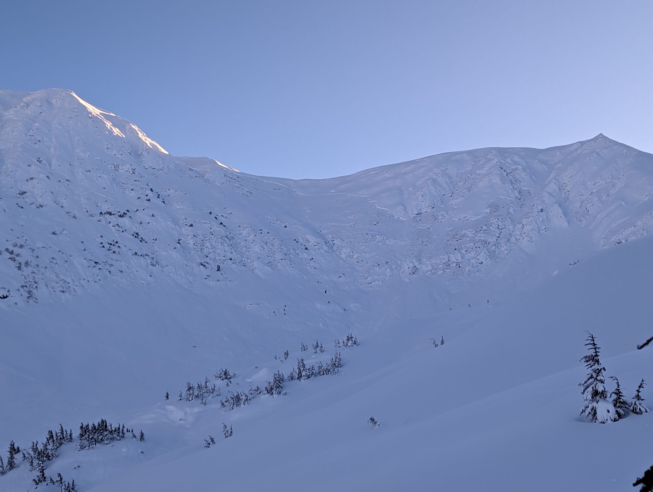
The avalanche danger is MODERATE above 1000′ today. Triggering a very large avalanche on a buried weak layer 3-6′ deep is possible. We have seen widespread avalanches on deeply buried weak layers this week, including many human triggered avalanches that were remote triggered from low angle terrain adjacent to steeper slopes. We recommend conservative terrain selection and decision-making today because the consequences of being involved with one of these large avalanches are very serious. Below 1000′ the avalanche danger is LOW.

SUMMIT LAKE / SEWARD / LOST LAKE / SNUG HARBOR: Similar conditions exist across the region with the potential for very large avalanches releasing on deeply buried weak layers. Observations from Summit Lake this week showed widespread avalanche activity and a very weak snowpack in many areas. A cautious mindset is recommended to avoid being involved with a very large avalanche.

Special Announcements

Join us at the Girdwood Brewing Co. from 5:30-7:00 p.m. on Thursday, Jan. 19 for the second Forecaster Chat of the season. CNFAIC forecaster Andrew Schauer will open the night with an overview of the state of the snowpack, followed by a discussion on how safe terrain management changes depending on the type of avalanche problem at hand. More details here.

Filing your PFD application? Our non-profit partner the Friends of Chugach Avalanche Center is an official Pick. Click. Give. organization, so please consider donating part of your PFD to support our avalanche forecast and public avalanche safety mission!!!

Sat, January 7th, 2023
Alpine
Above 2,500'
2 - Moderate
Avalanche risk
Treeline
1,000'-2,500'
2 - Moderate
Avalanche risk
Below Treeline
Below 1,000'
1 - Low
Avalanche risk
0 - No Rating
1 - Low
2 - Moderate
3 - Considerable
4 - High
5 - Extreme
Avalanche risk Avalanche risk Avalanche risk Avalanche risk Avalanche risk
Travel Advice Generally safe avalanche conditions. Watch for unstable snow on isolated terrain features. Heightened avalanche conditions on specific terrain features. Evaluate snow and terrain carefully; identify features of concern. Dangerous avalanche conditions. Careful snowpack evaluation, cautious route-finding, and conservative decision-making essential. Very dangerous avalanche conditions. Travel in avalanche terrain not recommended. Extraordinarily dangerous avalanche conditions. Avoid all avalanche terrain.
Likelihood of Avalanches Natural and human-triggered avalanches unlikely. Natural avalanches unlikely; human-triggered avalanches possible. Natural avalanches possible; human-triggered avalanches likely. Natural avalanches likely; human-triggered avalanches very likely. Natural and human-triggered avalanches certain.
Avalanche Size and Distribution Small avalanches in isolated areas or extreme terrain. Small avalanches in specific areas; or large avalanches in isolated areas. Small avalanches in many areas; or large avalanches in specific areas; or very large avalanches in isolated areas. Large avalanches in many areas; or very large avalanches in specific areas. Very large avalanches in many areas.
Recent Avalanches

Turnagain Pass:

As folks ventured into more areas yesterday there was a lot of older natural avalanche activity reported throughout Turnagain Pass. One group triggered a small avalanche in steep terrain near Tincan and were able to ski off the slab. Most of the avalanches observed yesterday likely released on Wednesday or Thursday after the last 1′ of snow fell in Turnagain Pass and strong winds rapidly loaded slopes. Several of the avalanches we saw released on the facets above the Thanksgiving crust with crown depths of 3-6’+ and propagation of 500-1000’+ across slope. These are very large avalanches that had long run outs into seemingly safe terrain. A sobering reminder of the high consequences of being involved with a large persistent slab avalanche. See observations for more details (Goldpan area, Lynx Creek, Lyon Creek).

Sincere thank you from the CNFAC forecast team to all who have submitted observations to help us catalog and understand this widespread avalanche cycle!!!

We saw at least 4 very large avalanches that released back to the Thanksgiving crust in the Bertha Creek/Cornbiscuit/Goldpan area. There were also several large avalanches at upper elevations that released within the recent storm snow layers. Photo 1.6.22

Very large and well connected avalanche from upper Lynx Creek. An observation reported widespread avalanche activity throughout this area. Photo from Sean Fallon 1.6.22

Natural avalanche with very wide propagation on the lower slopes of Pastoral. Photo Sam Volk 1.6.22

Avalanche Problem 1
  • Persistent Slabs
    Persistent Slabs
  • Aspect/Elevation
  • Certain
    Very Likely
    Likely
    Possible
    Unlikely
    Likelihood
  • Historic (D4-5)
    Very Large (D3)
    Large (D2)
    Small (D1)
    Size
Persistent Slabs
Persistent Slab avalanches are the release of a cohesive layer of snow (a slab) in the middle to upper snowpack, when the bond to an underlying persistent weak layer breaks. Persistent layers include: surface hoar, depth hoar, near-surface facets, or faceted snow. Persistent weak layers can continue to produce avalanches for days, weeks or even months, making them especially dangerous and tricky. As additional snow and wind events build a thicker slab on top of the persistent weak layer, this avalanche problem may develop into a Deep Persistent Slab.

Aspect/Elevation of the Avalanche Problem
Specialists develop a graphic representation of the potential distribution of a particular avalanche problem across the topography. This aspect/elevation rose is used to indicate where the particular avalanche problem is thought to exist on all elevation aspects. Areas where the avalanche problem is thought to exist are colored grey, and it is less likely to be encountered in areas colored white.

Likelihood of Avalanches
Terms such as "unlikely", "likely", and "certain" are used to define the scale, with the chance of triggering or observing avalanches increasing as we move up the scale. For our purposes, "Unlikely" means that few avalanches could be triggered in avalanche terrain and natural avalanches are not expected. "Certain" means that humans will be able to trigger avalanches on many slopes, and natural avalanches are expected.

Size of Avalanches
Avalanche size is defined by the largest potential avalanche, or expected range of sizes related to the problem in question. Assigned size is a qualitative estimate based on the destructive classification system and requires specialists to estimate the harm avalanches may cause to hypothetical objects located in the avalanche track (AAA 2016, CAA 2014). Under this schema, "Small" avalanches are not large enough to bury humans and are relatively harmless unless they carry people over cliffs or through trees or rocks. Moving up the scale, avalanches become "Large" enough to bury, injure, or kill people. "Very Large" avalanches may bury or destroy vehicles or houses, and "Historic" avalanches are massive events capable of altering the landscape.

Signal Word Size (D scale) Simple Descriptor
Small 1 Unlikely to bury a person
Large 2 Can bury a person
Very Large 3 Can destroy a house
Historic 4 & 5 Can destroy part or all of a village
More info at Avalanche.org

Another day of relatively quiet weather is on tap, with cloud cover increasing and moderate NW gap winds gusting up to 35 mph expected in areas that typically see outflow winds. We saw a lot of very large human triggered avalanches on Thursday that were mostly remote triggered from relatively low angle terrain (see obs here, here, and here). We also saw lots of evidence of a widespread natural avalanche cycle that likely occurred on Wednesday. Most of the largest avalanches observed in the past couple days appear to have released on a layer of facets above the Thanksgiving melt freeze crust that is buried roughly 3-6’+ deep. Triggering an avalanche on this weak layer is most likely above 2500′, but there have been some large avalanches releasing closer to 2000′ in elevation on buried weak layers from the Christmas and New Years storms.

While the likelihood of triggering one of these monster avalanches is decreasing as we get more time since the last storm, we still think it is possible for a person to trigger based on all the human triggered activity on Thursday. The consequences of being involved with one of these avalanches are serious! We recommend sticking to smaller terrain features with lower angle slopes and being aware of any steep slopes overhead. Remote triggering is likely with this weak layer, which means you could trigger an avalanche from relatively flat terrain that releases above, to the sides, or below where you are travelling. This is really important to keep in mind if you are travelling in the vicinity of other groups!

We don’t expect the NW winds to reach into the majority of the forecast area today, but the N end of Seattle Ridge is the most likely to experience these winds if they end up being stronger than expected. Wind slabs could form quickly on leeward slopes and the loading from wind transport could be enough to make deeper avalanches more likely. Be aware of any active wind loading in the area you are travelling, especially near higher elevation peaks and along Turnagain Arm.

Cornices also grew substantially with the past two storm systems and could be a potential trigger for a larger avalanche if they fall onto a steep slope below. Give these an extra wide berth and be aware of any cornices overhead, especially if you see any active wind loading today.

Weather
Sat, January 7th, 2023

Yesterday: Mostly clear skies and calm to light winds averaging 0-10 mph. There was a temperature inversion in some places with air temps in the single digits at road level in Turnagain Pass and teens at upper elevations. No new snowfall.

Today: Light outflow winds from the NW are expected to pick up today with averages in the 0-10 mph range and gusts up to 35 mph in favored areas like Turnagain Arm. Cloud cover will increase throughout the day starting with high level clouds and gradually dropping as a storm system approaches. Light snowfall is expected to start overnight Saturday or Sunday morning.

Tomorrow: Light snowfall should pick up Sunday morning, with up to 6″ expected by Monday morning. There is a lot of uncertainty with the timing and intensity of this storm system because weather models have poor agreement. Temperatures should increase slightly into the 20s at mid and upper elevations and snow line between 500 – 1000′. Winds will shift to the E and speeds should increase slightly to 15-25 mph with the onset of the storm.

PRECIPITATION 24-hour data (6am – 6am)

Temp Avg (F) Snow (in) Water (in) Snow Depth (in)
Center Ridge (1880′) 15 0 0 60
Summit Lake (1400′) 2 0 0 33
Alyeska Mid (1700′) 18 0 0 53
Bear Valley – Portage (132′) 19 0 0

RIDGETOP 24-hour data (6am – 6am)

Temp Avg (F) Wind Dir Wind Avg (mph) Wind Gust (mph)
Sunburst (3812′) 14 W 4 13
Seattle Ridge (2400′) 16
Observations
Recent Observations for Turnagain Pass
Date Region Location
04/16/24 Turnagain Observation: Cornbiscuit
04/15/24 Turnagain Observation: Taylor Pass
04/15/24 Turnagain Observation: Seward Highway – Tern Lake to Portage
04/14/24 Turnagain Observation: Sunburst
04/14/24 Turnagain Observation: Turnagain Pass Snomo
04/13/24 Turnagain Observation: Spokane Creek
04/11/24 Turnagain Observation: Tincan
04/10/24 Turnagain Avalanche: Seattle Ridge
04/10/24 Turnagain Observation: Cornbiscuit South Face
04/10/24 Turnagain Avalanche: Tincan
Riding Areas

The riding areas page has moved. Please click here & update your bookmarks.


Subscribe to Turnagain Pass
Avalanche Forecast by Email

This is a general backcountry avalanche advisory issued for Turnagain Arm with Turnagain Pass as the core advisory area. This advisory does not apply to highways, railroads or operating ski areas.