Turnagain Pass RSS

Archives
ARCHIVED - Forecasts expire after 24 hours.
Issued
Fri, January 6th, 2023 - 7:00AM
Expires
Sat, January 7th, 2023 - 7:00AM
Forecaster
Wendy Wagner
Avalanche risk The Bottom Line

The avalanche danger remains CONSIDERABLE above 2,500′ and MODERATE between 1000′ and 2,500′. Several large and dangerous avalanches were triggered by people yesterday and we recommend an extra cautious mindset again today. Large slabs were breaking in buried weak layers with crowns 3-8′ deep. These types of avalanches could be triggered by people again today. They could also be triggered remotely, from the side, top, or below a slope. Cornices are also large and could be close to failure, give these and extra wide berth. Signs are pointing to a dangerous snowpack despite the nice weather.

The danger is LOW below 1,000′ where only crusts exist.

SUMMIT LAKE:  Extra caution is recommended here as well as large avalanches could be triggered. Large collapses were reported in the Summit area yesterday.

LOST LAKE / SNUG HARBOR:  We have little information for these areas, which could be just as dangerous. Let us know what you see if you venture this way.

Fri, January 6th, 2023
Alpine
Above 2,500'
3 - Considerable
Avalanche risk
Treeline
1,000'-2,500'
2 - Moderate
Avalanche risk
Below Treeline
Below 1,000'
1 - Low
Avalanche risk
0 - No Rating
1 - Low
2 - Moderate
3 - Considerable
4 - High
5 - Extreme
Avalanche risk Avalanche risk Avalanche risk Avalanche risk Avalanche risk
Travel Advice Generally safe avalanche conditions. Watch for unstable snow on isolated terrain features. Heightened avalanche conditions on specific terrain features. Evaluate snow and terrain carefully; identify features of concern. Dangerous avalanche conditions. Careful snowpack evaluation, cautious route-finding, and conservative decision-making essential. Very dangerous avalanche conditions. Travel in avalanche terrain not recommended. Extraordinarily dangerous avalanche conditions. Avoid all avalanche terrain.
Likelihood of Avalanches Natural and human-triggered avalanches unlikely. Natural avalanches unlikely; human-triggered avalanches possible. Natural avalanches possible; human-triggered avalanches likely. Natural avalanches likely; human-triggered avalanches very likely. Natural and human-triggered avalanches certain.
Avalanche Size and Distribution Small avalanches in isolated areas or extreme terrain. Small avalanches in specific areas; or large avalanches in isolated areas. Small avalanches in many areas; or large avalanches in specific areas; or very large avalanches in isolated areas. Large avalanches in many areas; or very large avalanches in specific areas. Very large avalanches in many areas.
Recent Avalanches

A LOT of avalanche activity occurred yesterday on the southern end of Seattle Ridge. Some of these avalanches were very large with crowns up to 10′ deep in wind loaded areas. No one was caught in any that we know of. The weak layer in most appeared to be weak faceted snow near the base of the snowpack.

Backside of Seattle Ridge (Triangle Bowl/-3 Bowl):  A group of two snowmachiners remotely triggered a large slab avalanche on a northerly facing slope from ~100′ away (photo below). No one was caught. This avalanche likely sympathetically triggered at least two more avalanches lower and across the bowl. Additionally, these riders remotely triggered at least two very large slabs in the bowl to the south when on the ridge (also pictured below). Report from group HERE and our report HERE.

Backside of Seattle Ridge (Widowmaker Slide Path):  A relatively smaller slab was triggered by a person yesterday afternoon. Unknown what mode of travel or any other details at this time.

Front side of Seattle Ridge:  Several slabs pulled out in the steep gullies just across the motorized parking lot. We are unsure if they were triggered by riders along the ridge or natural from the very end of the strong winds the afternoon before (on 1/4/23). Let us know if you saw these on Wed, Jan 4th.

Summit Lake area:  Many large natural avalanches that released Wed, Jan 4th, during the strong winds were seen yesterday. See the photos HERE.

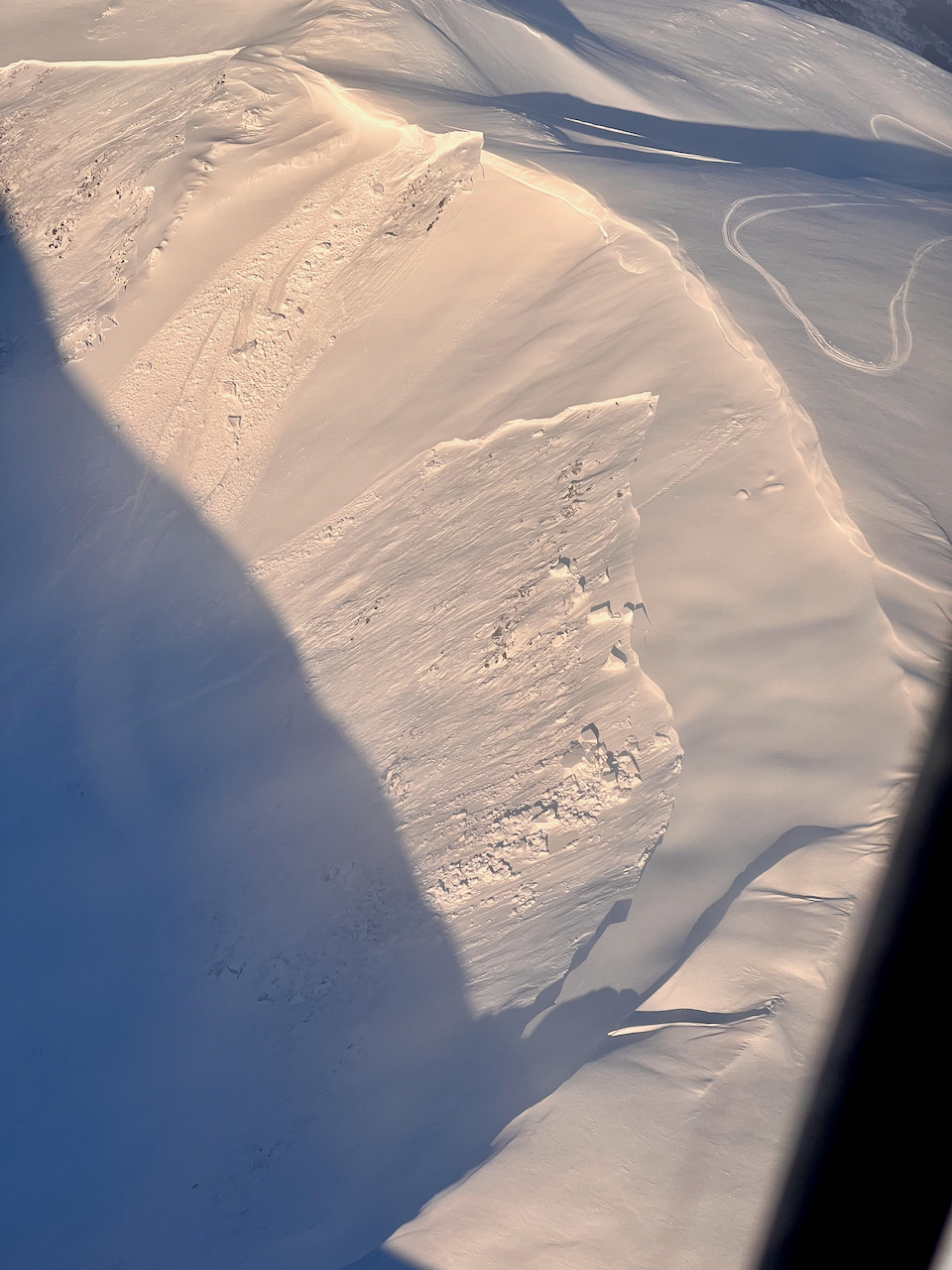
Large slab remotely triggered by 2 riders in Triangle/-3 Bowl yesterday morning. 1.5.23.


Looking up into Triangle/-3 Bowl at the remotely triggered slab on the right and sympathetically triggered slab on the left (SW aspect), a much larger slab also released out of view to the left of the photo . Photo by riders involved, 1.5.23.


Large slabs remotely triggered by the riders along the ridge. This is the bowl directly south of Triangle/-3 Bowl. Photo by Jon Davis, 1.5.23.


Slab that was triggered yesterday afternoon on the Widowmaker slide path. 1.5.23. 


Five slabs on the front side of Seattle Ridge. Unknown trigger. 1.5.23.


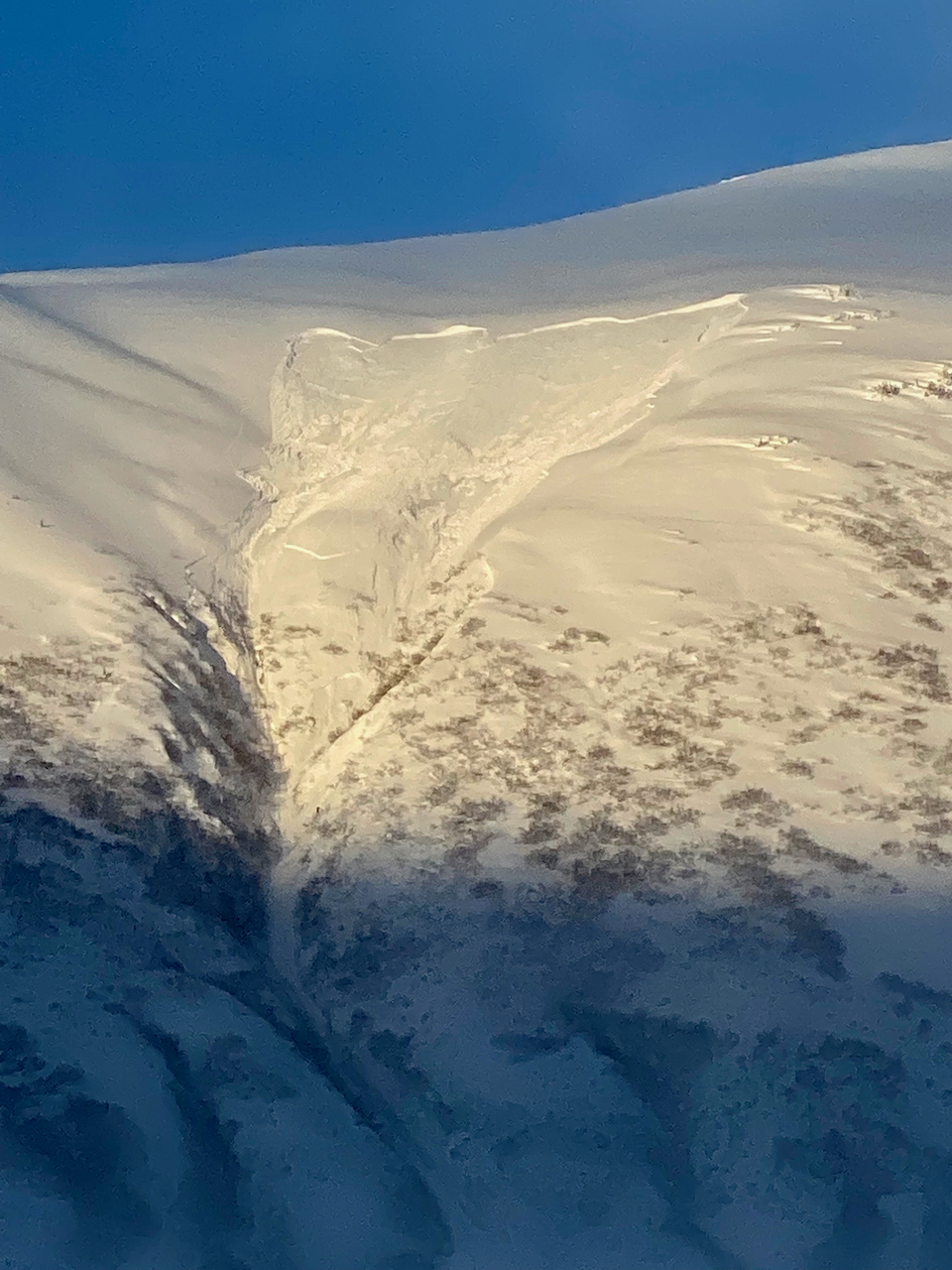
Close up on the slab on the front side of Seattle that is furthest to the left in above photo. 1.5.23. 

Avalanche Problem 1
  • Persistent Slabs
    Persistent Slabs
  • Aspect/Elevation
  • Certain
    Very Likely
    Likely
    Possible
    Unlikely
    Likelihood
  • Historic (D4-5)
    Very Large (D3)
    Large (D2)
    Small (D1)
    Size
Persistent Slabs
Persistent Slab avalanches are the release of a cohesive layer of snow (a slab) in the middle to upper snowpack, when the bond to an underlying persistent weak layer breaks. Persistent layers include: surface hoar, depth hoar, near-surface facets, or faceted snow. Persistent weak layers can continue to produce avalanches for days, weeks or even months, making them especially dangerous and tricky. As additional snow and wind events build a thicker slab on top of the persistent weak layer, this avalanche problem may develop into a Deep Persistent Slab.

Aspect/Elevation of the Avalanche Problem
Specialists develop a graphic representation of the potential distribution of a particular avalanche problem across the topography. This aspect/elevation rose is used to indicate where the particular avalanche problem is thought to exist on all elevation aspects. Areas where the avalanche problem is thought to exist are colored grey, and it is less likely to be encountered in areas colored white.

Likelihood of Avalanches
Terms such as "unlikely", "likely", and "certain" are used to define the scale, with the chance of triggering or observing avalanches increasing as we move up the scale. For our purposes, "Unlikely" means that few avalanches could be triggered in avalanche terrain and natural avalanches are not expected. "Certain" means that humans will be able to trigger avalanches on many slopes, and natural avalanches are expected.

Size of Avalanches
Avalanche size is defined by the largest potential avalanche, or expected range of sizes related to the problem in question. Assigned size is a qualitative estimate based on the destructive classification system and requires specialists to estimate the harm avalanches may cause to hypothetical objects located in the avalanche track (AAA 2016, CAA 2014). Under this schema, "Small" avalanches are not large enough to bury humans and are relatively harmless unless they carry people over cliffs or through trees or rocks. Moving up the scale, avalanches become "Large" enough to bury, injure, or kill people. "Very Large" avalanches may bury or destroy vehicles or houses, and "Historic" avalanches are massive events capable of altering the landscape.

Signal Word Size (D scale) Simple Descriptor
Small 1 Unlikely to bury a person
Large 2 Can bury a person
Very Large 3 Can destroy a house
Historic 4 & 5 Can destroy part or all of a village
More info at Avalanche.org

With another quiet (and sunny!) day on tap, triggering a large avalanche breaking in buried weak layers, anywhere from a couple feet deep to 8 or 10′ deep, is the main concern. To put it simply: we can’t have that many big avalanches triggered by two snowmachiners on the first nice day after a series of storms and not realize we have a serious HEADS UP snowpack.

This can be a tough situation because no signs of instability may be seen before a large and dangerous avalanche is triggered. There also could be areas that are much less likely to avalanche, but it is nearly impossible to really know what slopes those are and what ones are not. There has not been a lot of traffic (that we know of) outside of the ‘typical’ high use areas (i.e., the common bowl on Tincan and the front, westerly, lower angle slopes of Sunburst) in the last few days. I ‘glassed’ over to the non-moto side of Turnagian yesterday afternoon and did not see many tracks and no avalanches; you can only see so much from binoculars however.

Some points to consider for getting out in the backcountry today:

  • Thin areas in the snowpack are the most likely to avalanche. This includes upper elevations that see a lot of wind, the south end of Turnagain Pass, Johnson Pass, Lynx Cr, Silvertip and on to Summit Lake. Girdwood Valley may also be more of a problem spot.
  • Elevations near 2,500′ and above are most suspect. Debris may run into the lower elevations. The widowmaker slab (2,300′) may have released on a crust formed during the Xmas storm, which is about 3′ deep in this location.
  • Watch for other groups when traveling along ridgelines. If an avalanche is triggered from a safe area along the ridge, it could threaten another group that could be below you.
  • Cornices are large and re-shaped. Be sure to give them an extra wide berth. They could also trigger a large avalanche below.
  • To avoid this issue all together, we can stick to lower angle slopes (30 deg or less) with nothing steeper above us.

We investigated one of the remotely triggered avalanches yesterday and found the weak layer to be facets at the bottom of the snowpack. At this elevation (3,000′) and generally above 2,500′ no crusts were found in the slab from the Xmas or New Year storm. What we think was the Thanksgiving crust sat just above the faceted snow that was the weak layer – see crown profile below in a shallow area in the slab.


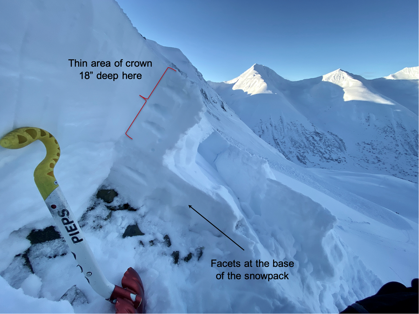
A look at the crown of the Triangle/-3 Bowl avalanche on a northerly aspect at 3,000′. This area was the safest to access and was in a very shallow section of the snowpack. 1.5.23.


Between 2,500′ and 2,000′ the Xmas storm created a crust with weaker snow on top that could be creating a weak layer closer to the surface. This layer was the likely culprit in the Widowmaker avalanche. Although this concern is in a small elevation band, it is looking like another layer we are concerned with. In short, there are several concerning weak layers that have been loaded by the storms over the past 2 weeks that have proven guilty.

Weather
Fri, January 6th, 2023

Yesterday:  Mostly sunny skies with patches of valley fog were over the region. Thicker fog built in over the east end of Turnagain Arm. Ridgetop winds were calm to very light from the east. Temperatures have cooled about 10-20 degrees over the past 24-hours and are in the low 20’sF at sea level, single digits in some valley bottoms, and in the teens along ridgelines.

Today:  Another sunny day is on tap with light westerly winds along the ridgetops. Some valley fog may linger today in areas close to Turnagain Arm. Temperatures should remain chilly, generally in the teens at most elevations save for some interior valley bottoms that may stay in the single digits.

Tomorrow:  Clouds look to move in tomorrow, Saturday, ahead of the next series of storms. Ridgetop winds should remain light from a northerly direction. Temperatures look to warm back into the 20’s. Snow and winds should begin Saturday night into Sunday morning. Models are suggesting up to 12-18″ by Monday morning with a rain/snow line climbing back to ~500. Stay tuned.

PRECIPITATION 24-hour data (6am – 6am)

Temp Avg (F) Snow (in) Water (in) Snow Depth (in)
Center Ridge (1880′) 21 0 0 62
Summit Lake (1400′) 12 0 0 33
Alyeska Mid (1700′) 25 0 0 53
Bear Valley – Portage (132′) 30 1 0.15

RIDGETOP 24-hour data (6am – 6am)

Temp Avg (F) Wind Dir Wind Avg (mph) Wind Gust (mph)
Sunburst (3812′) 18 NE 4 16
Seattle Ridge (2400′) 20 var 0 4
Observations
Recent Observations for Turnagain Pass
Date Region Location
04/16/24 Turnagain Observation: Cornbiscuit
04/15/24 Turnagain Observation: Taylor Pass
04/15/24 Turnagain Observation: Seward Highway – Tern Lake to Portage
04/14/24 Turnagain Observation: Sunburst
04/14/24 Turnagain Observation: Turnagain Pass Snomo
04/13/24 Turnagain Observation: Spokane Creek
04/11/24 Turnagain Observation: Tincan
04/10/24 Turnagain Avalanche: Seattle Ridge
04/10/24 Turnagain Observation: Cornbiscuit South Face
04/10/24 Turnagain Avalanche: Tincan
Riding Areas

The riding areas page has moved. Please click here & update your bookmarks.


Subscribe to Turnagain Pass
Avalanche Forecast by Email

This is a general backcountry avalanche advisory issued for Turnagain Arm with Turnagain Pass as the core advisory area. This advisory does not apply to highways, railroads or operating ski areas.