Today the avalanche danger is MODERATE above 1000′ where it’s possible to trigger an avalanche breaking on a buried weak layer 1-3′ deep within the snowpack. In steep terrain manage your sluff and give glide cracks and cornices a wide margin. Remember to use terrain progression and good travel protocol.
Special Announcements
The Hatcher Pass Avalanche Center and the Hatcher Pass Snow Riders Club are hosting a free avalanche workshop next Saturday at 11 am at the Mint parking lot. Check out our events page for more information!
Tue, January 7th, 2020
Alpine
Above 2,500'
2 - Moderate
Treeline
1,000'-2,500'
2 - Moderate
Below Treeline
Below 1,000'
1 - Low
0 - No Rating
1 - Low
2 - Moderate
3 - Considerable
4 - High
5 - Extreme
Travel Advice
Generally safe avalanche conditions. Watch for unstable snow on isolated terrain features.
Heightened avalanche conditions on specific terrain features. Evaluate snow and terrain carefully; identify features of concern.
Natural avalanches likely; human-triggered avalanches very likely.
Natural and human-triggered avalanches certain.
Avalanche Size and Distribution
Small avalanches in isolated areas or extreme terrain.
Small avalanches in specific areas; or large avalanches in isolated areas.
Small avalanches in many areas; or large avalanches in specific areas; or very large avalanches in isolated areas.
Large avalanches in many areas; or very large avalanches in specific areas.
Very large avalanches in many areas.
Recent Avalanches
A large skier triggered avalanche occurred Sunday, Jan 5th on Magnum’s West face. Details from the group involved are HERE and more information on the weak layer and avalanche details below.
Photo of Sunday’s slide on Magnum by Dane Ketner, who noticed the avalanche later in the day.
Avalanche Problem 1
Persistent Slabs
Certain
Very Likely
Likely
Possible
Unlikely
Likelihood
Historic (D4-5)
Very Large (D3)
Large (D2)
Small (D1)
Size
Persistent Slabs
Persistent Slab avalanches are the release of a cohesive layer of snow (a slab) in the middle to upper snowpack, when the bond to an underlying persistent weak layer breaks. Persistent layers include: surface hoar, depth hoar, near-surface facets, or faceted snow. Persistent weak layers can continue to produce avalanches for days, weeks or even months, making them especially dangerous and tricky. As additional snow and wind events build a thicker slab on top of the persistent weak layer, this avalanche problem may develop into a Deep Persistent Slab.
Likelihood of Avalanches
Terms such as "unlikely", "likely", and "certain" are used to define the scale, with the chance of triggering or observing
avalanches increasing as we move up the scale. For our purposes, "Unlikely" means that few avalanches could be triggered in avalanche terrain and
natural avalanches are not expected. "Certain" means that humans will be able to trigger avalanches on many slopes, and natural avalanches are expected.
Size of Avalanches
Avalanche size is defined by the largest potential avalanche, or expected range of sizes related to the problem in question.
Assigned size is a qualitative estimate based on the destructive classification system and requires specialists to estimate the harm avalanches may cause to
hypothetical objects located in the avalanche track (AAA 2016, CAA 2014). Under this schema, "Small" avalanches are not large enough to bury humans and are
relatively harmless unless they carry people over cliffs or through trees or rocks. Moving up the scale, avalanches become "Large" enough to bury, injure,
or kill people. "Very Large" avalanches may bury or destroy vehicles or houses, and "Historic" avalanches are massive events capable of altering the landscape.
Our primary layers of concern remains buried surface hoar from Solstice and old faceted snow, which sits within the top 3′ of snowpack in many areas throughout the region. The cold temperatures and relatively calm winds have had minimal impact on the healing process of this interface, so the concern remains.
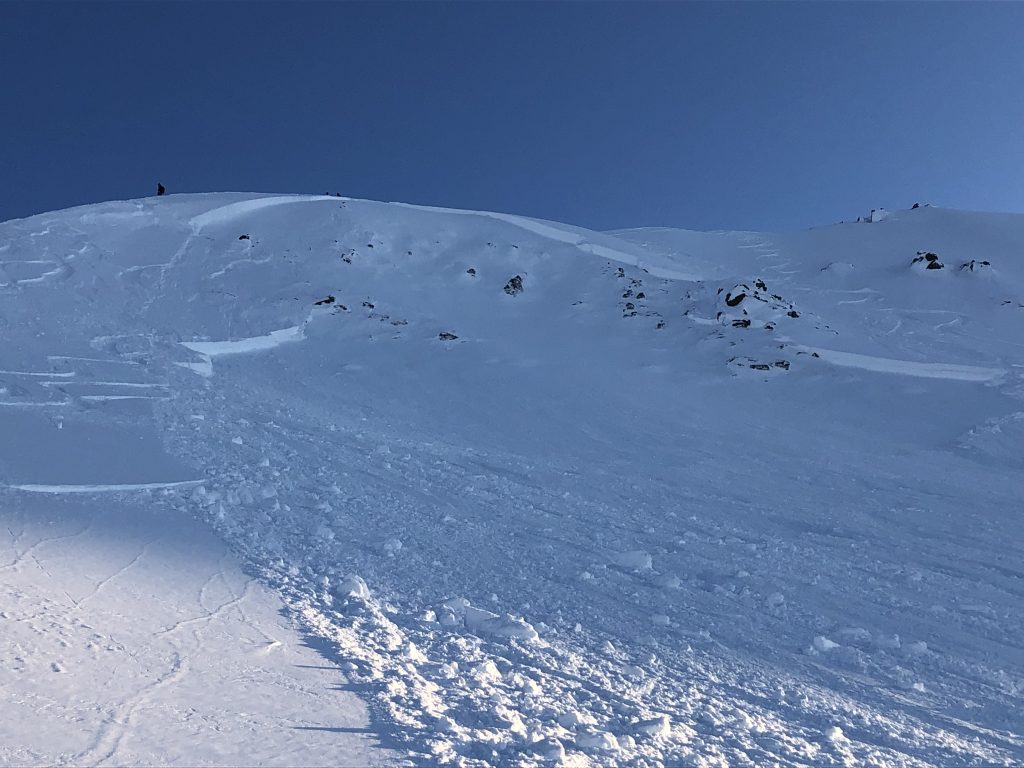
Yesterday, forecasters investigated a reported skier triggered slab avalanche from 1/5. This slab avalanche had a 1-4′ crown and ran from 3300′ to the debris pile at 2800′. Although it was initially suspected to have failed on the Solstice buried surface hoar, forecasters found the weak layer to be a bed of advanced facets over a dense crust. This interface is suspected to be from Dec. 9th when the region experienced a relatively warm rain event, reaching up to 3500′ in some areas. We’re grateful for the party involved for sharing photos and discussion.
A close up on the flank of the avalanche along with the upper portions of the crown. The thin area where the slab was triggered is out of view at the top.
1/5 Skier triggered avalanche on Magnum at 3300′. Photo from group involved
As these weak layers remain a concern:
Signs of instability are not likely to be present before a slope releases.
Thin areas are likely to be the trigger spots – on top of rollovers, near rocky outcrops and areas that have seen past scouring by the wind.
It’s possible to trigger this type of avalanche remotely – from the top, sides or below.
As always when traveling in avalanche terrain we expose only one person at a time, watch our partners, designate escape routes, and consider the consequences if the slope does slide. Avoid slopes that end in terrain traps, or have runout above rocky outcrops and over cliffs.
Dry Loose avalanches are the release of dry unconsolidated snow and typically occur within layers of soft snow near the surface of the snowpack. These avalanches start at a point and entrain snow as they move downhill, forming a fan-shaped avalanche. Other names for loose-dry avalanches include point-release avalanches or sluffs.
Likelihood of Avalanches
Terms such as "unlikely", "likely", and "certain" are used to define the scale, with the chance of triggering or observing
avalanches increasing as we move up the scale. For our purposes, "Unlikely" means that few avalanches could be triggered in avalanche terrain and
natural avalanches are not expected. "Certain" means that humans will be able to trigger avalanches on many slopes, and natural avalanches are expected.
Size of Avalanches
Avalanche size is defined by the largest potential avalanche, or expected range of sizes related to the problem in question.
Assigned size is a qualitative estimate based on the destructive classification system and requires specialists to estimate the harm avalanches may cause to
hypothetical objects located in the avalanche track (AAA 2016, CAA 2014). Under this schema, "Small" avalanches are not large enough to bury humans and are
relatively harmless unless they carry people over cliffs or through trees or rocks. Moving up the scale, avalanches become "Large" enough to bury, injure,
or kill people. "Very Large" avalanches may bury or destroy vehicles or houses, and "Historic" avalanches are massive events capable of altering the landscape.
Cold temperatures have maintained loose snow surface conditions throughout the region. Sluffs have been reported to be getting larger on steep sustained slopes. Remain mindful when traveling above rocky outcrops and over cliffs.
Additional Concern
Dry Loose
Dry Loose avalanches are the release of dry unconsolidated snow and typically occur within layers of soft snow near the surface of the snowpack. These avalanches start at a point and entrain snow as they move downhill, forming a fan-shaped avalanche. Other names for loose-dry avalanches include point-release avalanches or sluffs.
Glide cracks are an unpredictable hazard that continue to open in the cold temperatures. When possible, limit exposure near and under glide cracks. It can be difficult to see glide cracks when approached from above, especially when they’ve bridged with snow.
North aspect of Cornbiscuit – Some obvious, some less than obvious glide cracks.
Cornices: Avoid travel on cornices, and limit your exposure when beneath them. Cornices can obscure the true ridgeline and may fail far back from the edge.
Cornice view looking southeast on Magnum Ridge
Weather
Tue, January 7th, 2020
Yesterday: Cold and clear with some valley fog. Temperatures were -15°F to -6°F in most valley bottoms and low elevations while bumping to 0°F along ridges during the day. Winds remained light from the northwest.
Today: Cold, calm and clear weather remains in place. This morning, ridgetop winds are light and temperatures are mostly in the negative single digits with a high of 2°F expected this afternoon, and the low tonight near -8°F. Ridgetop winds are forecast from the northwest today at 5-10mph.
Tomorrow: The current cold, calm and clear pattern looks to continue through wednesday afternoon, then potential for cloudy skies moving into the region in the evening.
This is a general backcountry avalanche advisory issued for Turnagain Arm with Turnagain Pass as the core advisory area.
This advisory does not apply to highways, railroads or operating ski areas.