Turnagain Pass Avalanche Forecast
|
![]() ![]() |
The avalanche danger remains MODERATE above 1,000′. The possibility remains for a person to trigger a large slab, up to 3′ thick, due to a buried weak layer. Slabs are most likely to be triggered in thin areas and may also be triggered after several tracks are on a slope. Additionally, watch your sluff, these are getting larger on steep slopes. As always, give cornices a wide berth and limit exposure under opening glide cracks.
Another large slab avalanche was triggered yesterday in our forecast zone; three others were triggered in Seattle Ck Drainage Friday and one on Fresno in the Summit Lake area Saturday. Yesterday’s slide was on the West face of Magnum (2,900′) and triggered by a skier at the top of the slope. The avalanche took out previous tracks and is believed to have released in a weak layer buried during Solstice. It was triggered at a thin spot in the slab that can be seen in the middle of the crown in the photo below. No one was caught and the skier was able to get off the slab at the top. A big thank you to the group for sharing their details and photos.
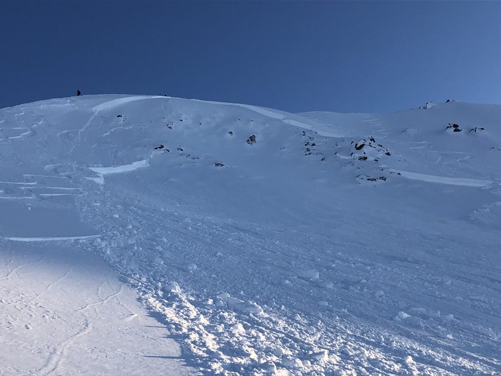
Looking up at the Magnum slide from yesterday, 1/5/19, West aspect, 2,900′. Note how the crown is thin in the middle, to the right of the skier in the photo. This thin area is where the skier reported to have triggered the slide. Photo from group involved.
Looking down from the crown at the debris, which covered previous tracks. Photo from group who triggered the slide.
Signal Word | Size (D scale) | Simple Descriptor |
Small | 1 | Unlikely to bury a person |
Large | 2 | Can bury a person |
Very Large | 3 | Can destroy a house |
Historic | 4 & 5 | Can destroy part or all of a village |
Although the weather continues to be cold, calm and clear, triggering a large slab, similar to the one above, that breaks in weak snow 1-3′ below the surface remains our primary concern. Buried just over two weeks ago, during Solstice, was a layer of surface hoar and near surface facets. This layer now lurks between 1 and 3 feet below the soft snow surface and is still causing us grief as seen yesterday.
As long as this weak layer remains a concern, things to keep in mind:
Using good travel habits is key with this problem as it can be quite tricky. Exposing one person at a time, watching our partners, having escape routes planned and considering the consequences if the slope does slide are good ways to help stack the odds in our favor. For instance, avoiding slopes that end in terrain traps, where debris can pile up.
Snowpack at 3,000′ in Seattle Ck Drainage. Snow pit tests showed this weak layer took a lot of force to fail, but once it failed, slid easily. Less force is needed in thinner sections of the slab however. See VIDEO.
Signal Word | Size (D scale) | Simple Descriptor |
Small | 1 | Unlikely to bury a person |
Large | 2 | Can bury a person |
Very Large | 3 | Can destroy a house |
Historic | 4 & 5 | Can destroy part or all of a village |
The cold temperatures are faceting and loosing the surface snow more and more each day. Sluffs have been reported to be getting larger on steep sustained slopes. Watch your sluff.
Glide cracks continue to open with the cold temperatures which is another interesting factor with this unpredictable hazard. Limit time spent underneath glide cracks as they could release into a dangerous glide avalanche at any time.
Cornices: Avoid traveling on cornices and limit exposure when passing beneath. Even with the cold benign weather, they can still be teetering on the brink of failure and break farther back than expected.
Yesterday: Cold and clear weather prevailed again yesterday. Temperatures were in the minus single digits in most valley bottoms and low elevations while bumping to 0F or just above along ridgelines during the day. Winds remained light from the West.
Today: Cold, calm and clear weather remains in place. This morning, ridgetop winds are light and variable and temperatures are in the minus single digits at most locations. Ridgetop winds are forecast to turn westerly today and blow 5-10mph. Temperatures are expected to remain in the -10 to 0F range through the day and into tonight.
Tomorrow: The current cold and clear pattern looks to continue well into the week. There looks to be the potential for some stronger northerly winds on Wednesday, stay tuned!
PRECIPITATION 24-hour data (6am – 6am)
Temp Avg (F) | Snow (in) | Water (in) | Snow Depth (in) | |
---|---|---|---|---|
Center Ridge (1880′) | -3 | 0 | 0 | 39 |
Summit Lake (1400′) | -12 | 0 | 0 | 14 |
Alyeska Mid (1700′) | -1 | 0 | 0 | 36 |
RIDGETOP 24-hour data (6am – 6am)
Temp Avg (F) | Wind Dir | Wind Avg (mph) | Wind Gust (mph) | |
---|---|---|---|---|
Sunburst (3812′) | -1 | W | 7 | 19 |
Seattle Ridge (2400′) | 0 | var | 2 | 4 |
Date | Region | Location | Observer |
---|---|---|---|
05/22/23 | Turnagain | Avalanche: Tincan | Nick D'Alessio |
05/12/23 | Turnagain | Avalanche: Tincan, Sunburst, Magnum, Cornbiscuit | Heather Thamm |
05/07/23 | Turnagain | Observation: Tincan – Bear Tracks | CNFAIC Staff |
05/05/23 | Turnagain | Observation: Seattle Ridge | AS/ WW Forecaster |
05/02/23 | Turnagain | Observation: Cornbiscuit | Schauer/ Sturgess Forecaster |
05/02/23 | Turnagain | Observation: Seward Hwy Turnagain Pass | Joel Curtis |
04/30/23 | Turnagain | Observation: Magnum | Ayla, Kit Crosby, Barton |
04/29/23 | Turnagain | Observation: Tincan | John Sykes |
04/28/23 | Turnagain | Avalanche: Taylor Pass/Pastoral | Schauer/ Creighton Forecaster |
04/28/23 | Turnagain | Avalanche: Tincan | Andy Moderow |
Status of riding areas across the Chugach NF is managed by the Glacier and Seward Ranger Districts, not avalanche center staff. Riding area information is posted as a public service to our users and updated based on snow depth and snow density to prevent resource damage at trailhead locations. Riding area questions contact: mailroom_r10_chugach@fs.fed.us
Area | Status | Weather & Riding Conditions |
---|---|---|
Glacier District |
Subscribe to Turnagain Pass
Avalanche Forecast by Email
This is a general backcountry avalanche advisory issued for Turnagain Arm with Turnagain Pass as the core advisory area. This advisory does not apply to highways, railroads or operating ski areas.