Turnagain Pass RSS

Archives
ARCHIVED - Forecasts expire after 24 hours.
Issued
Mon, January 4th, 2021 - 7:00AM
Expires
Tue, January 5th, 2021 - 7:00AM
Forecaster
Andrew Schauer
Avalanche risk The Bottom Line

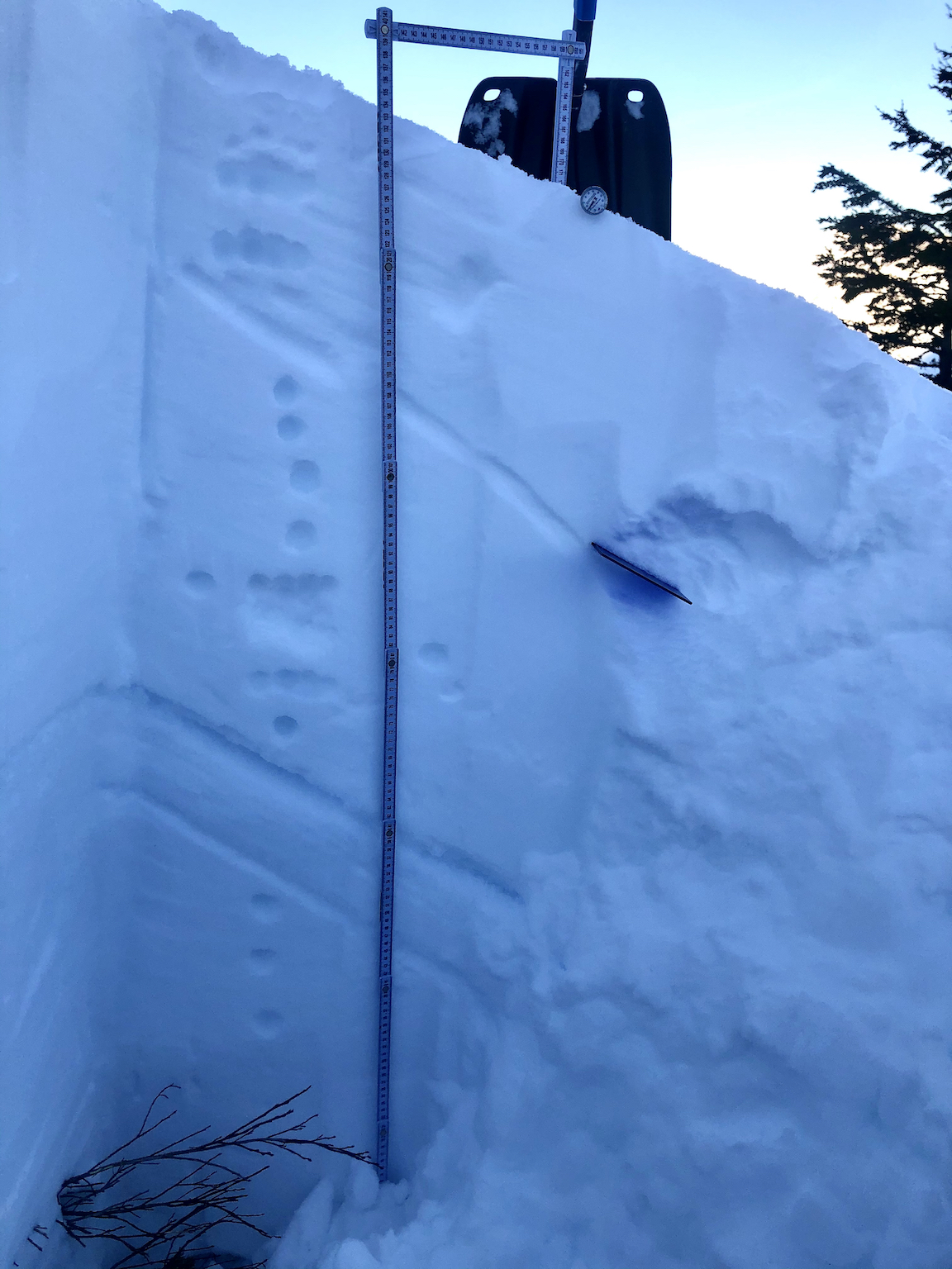
Today’s avalanche danger will rise to CONSIDERABLE above 2500’ as a storm moving in this afternoon will make it likely that a person could trigger a wind slab avalanche up to a foot deep. The avalanche danger is expected to remain at MODERATE for elevations below 2500’, where lighter winds and lower snowfall totals will make smaller wind slab avalanches possible, and there is still a small chance of triggering a deeper avalanche on a weak layer buried 3-5’ deep. Pay attention to increasing danger as the weather picks up this afternoon, and seek out lower angle terrain if you start to notice signs of instability.

SUMMIT LAKE: The Summit Lake area has a thinner and weaker snowpack than Turnagain Pass. In addition to the avalanche issues mentioned above, there is still an unlikely chance a person could trigger an avalanche breaking near the ground above 2500′.

Mon, January 4th, 2021
Alpine
Above 2,500'
3 - Considerable
Avalanche risk
Treeline
1,000'-2,500'
2 - Moderate
Avalanche risk
Below Treeline
Below 1,000'
2 - Moderate
Avalanche risk
0 - No Rating
1 - Low
2 - Moderate
3 - Considerable
4 - High
5 - Extreme
Avalanche risk Avalanche risk Avalanche risk Avalanche risk Avalanche risk
Travel Advice Generally safe avalanche conditions. Watch for unstable snow on isolated terrain features. Heightened avalanche conditions on specific terrain features. Evaluate snow and terrain carefully; identify features of concern. Dangerous avalanche conditions. Careful snowpack evaluation, cautious route-finding, and conservative decision-making essential. Very dangerous avalanche conditions. Travel in avalanche terrain not recommended. Extraordinarily dangerous avalanche conditions. Avoid all avalanche terrain.
Likelihood of Avalanches Natural and human-triggered avalanches unlikely. Natural avalanches unlikely; human-triggered avalanches possible. Natural avalanches possible; human-triggered avalanches likely. Natural avalanches likely; human-triggered avalanches very likely. Natural and human-triggered avalanches certain.
Avalanche Size and Distribution Small avalanches in isolated areas or extreme terrain. Small avalanches in specific areas; or large avalanches in isolated areas. Small avalanches in many areas; or large avalanches in specific areas; or very large avalanches in isolated areas. Large avalanches in many areas; or very large avalanches in specific areas. Very large avalanches in many areas.
Recent Avalanches

Skiers backed off of their objective near the south end of Seattle Ridge yesterday, noticing shooting cracks in a fresh, unsupported wind slab as they gained elevation.

Avalanche Problem 1
  • Wind Slabs
    Wind Slabs
  • Certain
    Very Likely
    Likely
    Possible
    Unlikely
    Likelihood
  • Historic (D4-5)
    Very Large (D3)
    Large (D2)
    Small (D1)
    Size
Wind Slabs
Wind Slab avalanches are the release of a cohesive layer of snow (a slab) formed by the wind. Wind typically transports snow from the upwind sides of terrain features and deposits snow on the downwind side. Wind slabs are often smooth and rounded and sometimes sound hollow, and can range from soft to hard. Wind slabs that form over a persistent weak layer (surface hoar, depth hoar, or near-surface facets) may be termed Persistent Slabs or may develop into Persistent Slabs.

Likelihood of Avalanches
Terms such as "unlikely", "likely", and "certain" are used to define the scale, with the chance of triggering or observing avalanches increasing as we move up the scale. For our purposes, "Unlikely" means that few avalanches could be triggered in avalanche terrain and natural avalanches are not expected. "Certain" means that humans will be able to trigger avalanches on many slopes, and natural avalanches are expected.

Size of Avalanches
Avalanche size is defined by the largest potential avalanche, or expected range of sizes related to the problem in question. Assigned size is a qualitative estimate based on the destructive classification system and requires specialists to estimate the harm avalanches may cause to hypothetical objects located in the avalanche track (AAA 2016, CAA 2014). Under this schema, "Small" avalanches are not large enough to bury humans and are relatively harmless unless they carry people over cliffs or through trees or rocks. Moving up the scale, avalanches become "Large" enough to bury, injure, or kill people. "Very Large" avalanches may bury or destroy vehicles or houses, and "Historic" avalanches are massive events capable of altering the landscape.

Signal Word Size (D scale) Simple Descriptor
Small 1 Unlikely to bury a person
Large 2 Can bury a person
Very Large 3 Can destroy a house
Historic 4 & 5 Can destroy part or all of a village
More info at Avalanche.org

Last night brought 1-2” of light snow to the mountains near Girdwood, leaving Turnagain Pass high and dry as of 5:00 this morning. With 6-8” more snow (equaling around 0.5” snow water equivalent) possible by early evening and easterly ridgetop winds blowing 15-20 mph, avalanche conditions are expected to become more dangerous through the day. At upper elevations where the snow and wind will be the most intense, it will become likely that a human could trigger an avalanche 1’ deep in new and wind-drifted snow.

This new snow is falling on mixed surfaces, with a layer of surface hoar up to 1000-2000’, near-surface facets up to the ridgetops, and some firm, wind-scoured surfaces at mid- to upper elevations. The combination of a fresh slab sitting on weak snow will mean dangerous avalanche conditions, making it possible that avalanches failing at the new/old snow interface could propagate wider than normal. Pay attention to clear signs of instability as the day progresses. Shooting cracks, collapsing, and new avalanche activity are all clear indicators that avalanche danger is increasing and it is time to move to low-angle terrain and avoid runout zones.

Cornices: New snow and winds are making cornices a little more sensitive today. As always, be sure to give them plenty of space as they can break farther back than you might think.

Sluffs: A few inches of low-density snow will be eager to move in steeper terrain. If you do decide to move into steeper slopes, be on the lookout for loose snow avalanches gaining momentum, especially as snow picks up this afternoon.

Yesterday’s surface hoar will be today’s weak layer. Pete’s North, 1600′. 01.03.2021

Avalanche Problem 2
  • Deep Persistent Slabs
    Deep Persistent Slabs
  • Certain
    Very Likely
    Likely
    Possible
    Unlikely
    Likelihood
  • Historic (D4-5)
    Very Large (D3)
    Large (D2)
    Small (D1)
    Size
Deep Persistent Slabs
Deep Persistent Slab avalanches are the release of a thick cohesive layer of hard snow (a slab), when the bond breaks between the slab and an underlying persistent weak layer deep in the snowpack. The most common persistent weak layers involved in deep, persistent slabs are depth hoar or facets surrounding a deeply buried crust. Deep Persistent Slabs are typically hard to trigger, are very destructive and dangerous due to the large mass of snow involved, and can persist for months once developed. They are often triggered from areas where the snow is shallow and weak, and are particularly difficult to forecast for and manage.

Likelihood of Avalanches
Terms such as "unlikely", "likely", and "certain" are used to define the scale, with the chance of triggering or observing avalanches increasing as we move up the scale. For our purposes, "Unlikely" means that few avalanches could be triggered in avalanche terrain and natural avalanches are not expected. "Certain" means that humans will be able to trigger avalanches on many slopes, and natural avalanches are expected.

Size of Avalanches
Avalanche size is defined by the largest potential avalanche, or expected range of sizes related to the problem in question. Assigned size is a qualitative estimate based on the destructive classification system and requires specialists to estimate the harm avalanches may cause to hypothetical objects located in the avalanche track (AAA 2016, CAA 2014). Under this schema, "Small" avalanches are not large enough to bury humans and are relatively harmless unless they carry people over cliffs or through trees or rocks. Moving up the scale, avalanches become "Large" enough to bury, injure, or kill people. "Very Large" avalanches may bury or destroy vehicles or houses, and "Historic" avalanches are massive events capable of altering the landscape.

Signal Word Size (D scale) Simple Descriptor
Small 1 Unlikely to bury a person
Large 2 Can bury a person
Very Large 3 Can destroy a house
Historic 4 & 5 Can destroy part or all of a village
More info at Avalanche.org

The facet/crust combination from the Dec.1 rain event will be another concern today. While these storm totals are not enormous, a relatively small avalanche failing near the surface of the snowpack could provide a substantial load to a suspect layer in some parts of our forecast area, and there is a chance it could step down to create a large avalanche 3-5′ deep. This layer seems to be the weakest towards the south end of Turnagain pass, especially on the non-motorized side. This layer only exists up to about 2500’, and although it is unlikely to trigger an avalanche on this layer, we still cannot rule it out entirely.

The dark line in the middle of this snowpit is the 12/1 rain crust we have been talking about. While it is not a concern everywhere, it does seem to be harboring weak snow towards the south end of Turnagain Pass. Photo: Eric Roberts. 01.01.2021


Weather
Mon, January 4th, 2021

Yesterday: The day started off cold, with temperatures in the single digits F at valley bottoms and in the mid- teens at higher elevations, warming into the upper teens to low 20’s F. Cloud cover increased throughout the day, and winds were blowing 5-15 mph out of the east. Light snowfall last night brought 1-2” snow as of 5:00 this morning.

Today: Snowfall is expected to pick up around noon today, with periods of heavy snowfall expected this afternoon bringing 6-8″ snow equalling 0.5″ SWE by the end of the day. Easterly ridgetop winds are expected to pick up to 15-20 mph through the day, with gusts near 30 mph. We are expecting to see snow to sea level as high temperatures reach the mid-20’s F at lower elevations and upper teens F at higher elevations, with temperatures expected in the upper teens to upper 20’s tonight.

Tomorrow: Winds are expected to increase tomorrow, blowing 25-30 mph out of the east at the ridgetops. High temperatures will be in the high teens to low 20’s F. We should see a break in the snowfall tomorrow, with more to come later in the week.

PRECIPITATION 24-hour data (6am – 6am)

Temp Avg (F) Snow (in) Water (in) Snow Depth (in)
Center Ridge (1880′) 21 0 0 74
Summit Lake (1400′) 14 1 0.1 30
Alyeska Mid (1700′) 23 1 0.06 79

RIDGETOP 24-hour data (6am – 6am)

Temp Avg (F) Wind Dir Wind Avg (mph) Wind Gust (mph)
Sunburst (3812′) 17 NE 10 25
Seattle Ridge (2400′) 19 SE 10 19
Observations
Recent Observations for Turnagain Pass
Date Region Location
04/23/24 Turnagain Observation: Turnagain Sunny Side
04/21/24 Turnagain Observation: Bertha Creek
04/20/24 Turnagain Avalanche: Spokane Creek
04/16/24 Turnagain Observation: Cornbiscuit
04/15/24 Turnagain Observation: Taylor Pass
04/15/24 Turnagain Observation: Seward Highway – Tern Lake to Portage
04/14/24 Turnagain Observation: Sunburst
04/14/24 Turnagain Observation: Turnagain Pass Snomo
04/13/24 Turnagain Observation: Spokane Creek
04/11/24 Turnagain Observation: Tincan
Riding Areas

The riding areas page has moved. Please click here & update your bookmarks.


Subscribe to Turnagain Pass
Avalanche Forecast by Email

This is a general backcountry avalanche advisory issued for Turnagain Arm with Turnagain Pass as the core advisory area. This advisory does not apply to highways, railroads or operating ski areas.