Turnagain Pass RSS

Archives
ARCHIVED - Forecasts expire after 24 hours.
Issued
Tue, January 5th, 2021 - 7:00AM
Expires
Wed, January 6th, 2021 - 7:00AM
Forecaster
Aleph Johnston-Bloom
Avalanche risk The Bottom Line

The avalanche danger is MODERATE today above 1000′. Triggering a wind slab in steep wind-loaded terrain remains possible. Watch for blowing snow and signs of wind effect on the snow surface.  Give cornices a wide berth.

The avalanche danger is LOW below 1000’.

Tue, January 5th, 2021
Alpine
Above 2,500'
2 - Moderate
Avalanche risk
Treeline
1,000'-2,500'
2 - Moderate
Avalanche risk
Below Treeline
Below 1,000'
1 - Low
Avalanche risk
0 - No Rating
1 - Low
2 - Moderate
3 - Considerable
4 - High
5 - Extreme
Avalanche risk Avalanche risk Avalanche risk Avalanche risk Avalanche risk
Travel Advice Generally safe avalanche conditions. Watch for unstable snow on isolated terrain features. Heightened avalanche conditions on specific terrain features. Evaluate snow and terrain carefully; identify features of concern. Dangerous avalanche conditions. Careful snowpack evaluation, cautious route-finding, and conservative decision-making essential. Very dangerous avalanche conditions. Travel in avalanche terrain not recommended. Extraordinarily dangerous avalanche conditions. Avoid all avalanche terrain.
Likelihood of Avalanches Natural and human-triggered avalanches unlikely. Natural avalanches unlikely; human-triggered avalanches possible. Natural avalanches possible; human-triggered avalanches likely. Natural avalanches likely; human-triggered avalanches very likely. Natural and human-triggered avalanches certain.
Avalanche Size and Distribution Small avalanches in isolated areas or extreme terrain. Small avalanches in specific areas; or large avalanches in isolated areas. Small avalanches in many areas; or large avalanches in specific areas; or very large avalanches in isolated areas. Large avalanches in many areas; or very large avalanches in specific areas. Very large avalanches in many areas.
Avalanche Problem 1
  • Wind Slabs
    Wind Slabs
  • Certain
    Very Likely
    Likely
    Possible
    Unlikely
    Likelihood
  • Historic (D4-5)
    Very Large (D3)
    Large (D2)
    Small (D1)
    Size
Wind Slabs
Wind Slab avalanches are the release of a cohesive layer of snow (a slab) formed by the wind. Wind typically transports snow from the upwind sides of terrain features and deposits snow on the downwind side. Wind slabs are often smooth and rounded and sometimes sound hollow, and can range from soft to hard. Wind slabs that form over a persistent weak layer (surface hoar, depth hoar, or near-surface facets) may be termed Persistent Slabs or may develop into Persistent Slabs.

Likelihood of Avalanches
Terms such as "unlikely", "likely", and "certain" are used to define the scale, with the chance of triggering or observing avalanches increasing as we move up the scale. For our purposes, "Unlikely" means that few avalanches could be triggered in avalanche terrain and natural avalanches are not expected. "Certain" means that humans will be able to trigger avalanches on many slopes, and natural avalanches are expected.

Size of Avalanches
Avalanche size is defined by the largest potential avalanche, or expected range of sizes related to the problem in question. Assigned size is a qualitative estimate based on the destructive classification system and requires specialists to estimate the harm avalanches may cause to hypothetical objects located in the avalanche track (AAA 2016, CAA 2014). Under this schema, "Small" avalanches are not large enough to bury humans and are relatively harmless unless they carry people over cliffs or through trees or rocks. Moving up the scale, avalanches become "Large" enough to bury, injure, or kill people. "Very Large" avalanches may bury or destroy vehicles or houses, and "Historic" avalanches are massive events capable of altering the landscape.

Signal Word Size (D scale) Simple Descriptor
Small 1 Unlikely to bury a person
Large 2 Can bury a person
Very Large 3 Can destroy a house
Historic 4 & 5 Can destroy part or all of a village
More info at Avalanche.org

Yesterday the forecast wind and snow did not materialize. However, winds on Sunday and Sunday night were strong enough to blow the light surface snow around and winds may be gusty at times today at upper elevations. Winds have already bumped up a bit this morning. Today it will be important to watch for blowing snow and wind slabs in steep wind exposed terrain near ridgetops, on convex rollovers, or in cross-loaded gullies. Look for stiff wind affected snow and cracking in the snow around you. Even a small wind slab triggered in high consequence zones can be quite dangerous if you get knocked off your feet. As always, keep a close eye on the surface conditions and know your escape routes if a small slab happens to break under you.

Cornices: Give cornices plenty of room and limit your time traveling below them.

Sluffs: Be aware of loose snow avalanches moving in steeper terrain wherever there is soft snow at the surface. With enough volume these can pick up momentum, enough to carry a person, and can be particularly dangerous if you are caught above terrain traps like cliffs, rocks, or gullies.

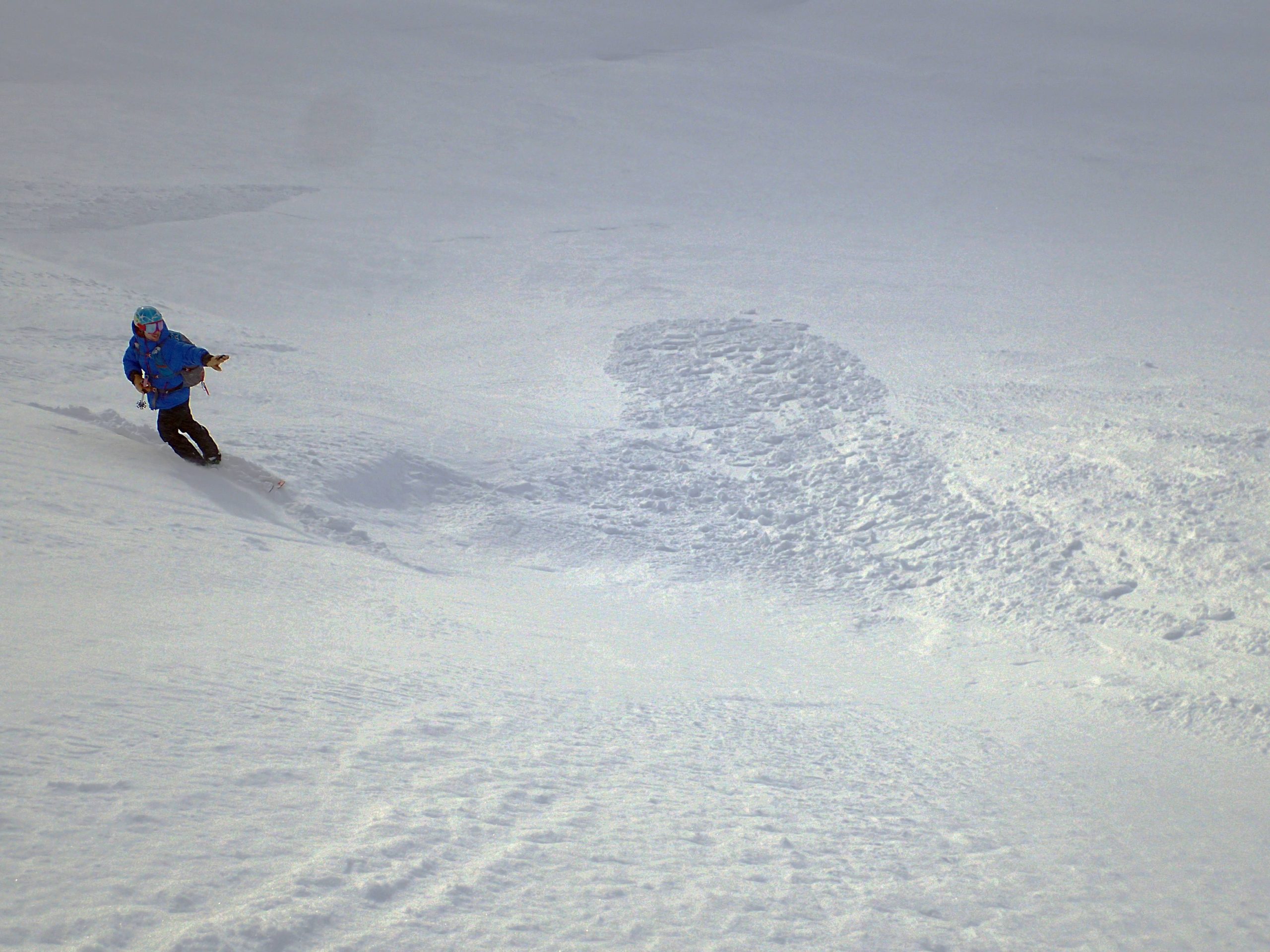
Small wind slab on the apron of a couloir in the Library. 1.3.21. Photo: A Meyerhofer. 

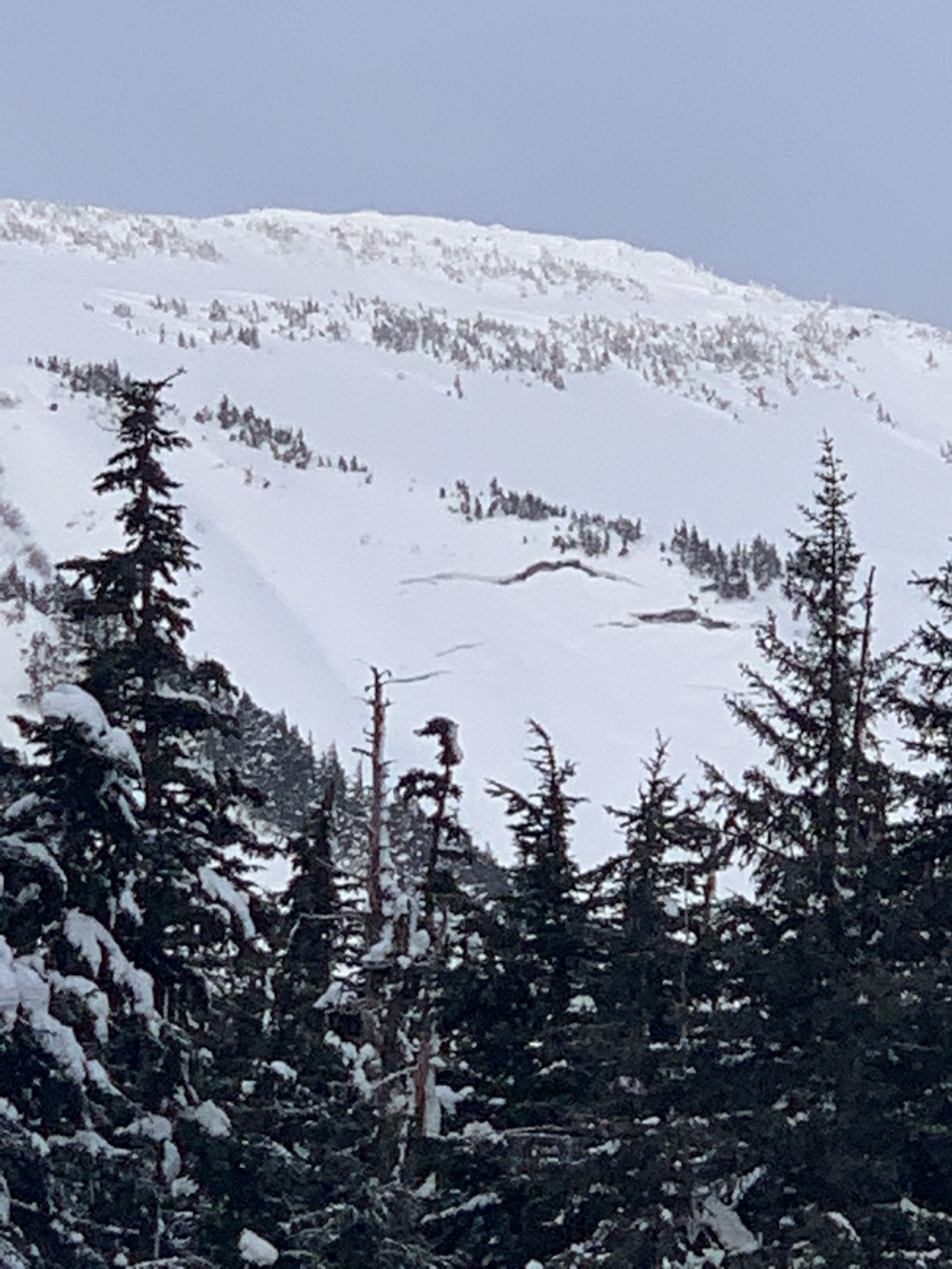
Active flagging on Kickstep ridge around 3500’ and to the summit on Sunday, 1.3.21. Photo: Emily Sullivan

Additional Concern
  • Deep Persistent Slabs
    Deep Persistent Slabs
Deep Persistent Slabs
Deep Persistent Slab avalanches are the release of a thick cohesive layer of hard snow (a slab), when the bond breaks between the slab and an underlying persistent weak layer deep in the snowpack. The most common persistent weak layers involved in deep, persistent slabs are depth hoar or facets surrounding a deeply buried crust. Deep Persistent Slabs are typically hard to trigger, are very destructive and dangerous due to the large mass of snow involved, and can persist for months once developed. They are often triggered from areas where the snow is shallow and weak, and are particularly difficult to forecast for and manage.
More info at Avalanche.org
  • The December 1st rain crust/facet combination that we have been discussing as a layer of concern has become a layer to track at this point. The snowpack has had time to adjust to last major loading event and this layering structure and facet development is quite variable across the forecast area. Triggering an avalanche on this crust/facet layer is unlikely. However, we will continue to evaluate the progression of faceting above and below the December 1st rain crust as well as any future failure/avalanche potential. This type of set-up has a nasty habit of waking up from dormancy with additional loading, even if it is deep in the snowpack.
  • Glide avalanches: On a completely different note we have another additional concern to track. Glide cracks have been observed in Summit Lake on Gilpatrick and in Turnagain Pass on Seattle Ridge.  Watch for additional cracks appearing in the region and remember to limit time spent underneath glide cracks as they are totally unpredictable and can release without warning.

Glide cracks on Seattle Ridge north of the uptrack. 1.3.21. Photo: Rachel Heath.


Weather
Tue, January 5th, 2021

Yesterday: Skies were cloudy with very light snow showers and a trace of accumulation. Temperatures were in the 20°Fs and winds were easterly 5-15 mph with gusts into the 20s. Overnight skies remained cloudy with a continued very light dusting of snow, temperatures remained in the 20°Fs and winds were easterly 5-10 mph with gusts into the high teens.

Today: Mostly cloudy skies becoming partly cloudy in the afternoon and a chance of scattered snow showers. Winds will be easterly 5-15 mph with gusts into the 20s and 30s and temperatures will be in the 20°Fs. Tonight skies will be partly cloudy becoming mostly cloudy with snow showers likely early Wednesday morning. Temperatures will remain in the 20°Fs and easterly winds continue, 5-15 mph with gusts into the 20s increasing in the early morning hours on Wednesday.

Tomorrow: Snow and rain showers are likely as the temperatures rise into the 30°Fs at sea level and high 20°Fs at upper elevations as the next storm moves into the region with some warmer air. Easterly winds will increase to 15-25 mph with gusts into the 40s. Rain and snow with some periods of heavy precipitation and elevated winds are forecast through Thursday.

PRECIPITATION 24-hour data (6am – 6am)

Temp Avg (F) Snow (in) Water (in) Snow Depth (in)
Center Ridge (1880′) 27 trace 0 74
Summit Lake (1400′) 25 trace 0 30
Alyeska Mid (1700′) 26 trace 0 78

RIDGETOP 24-hour data (6am – 6am)

Temp Avg (F) Wind Dir Wind Avg (mph) Wind Gust (mph)
Sunburst (3812′) 19 E 9 27
Seattle Ridge (2400′) 23 E 4 15
Observations
Recent Observations for Turnagain Pass
Date Region Location
04/21/24 Turnagain Observation: Bertha Creek
04/20/24 Turnagain Avalanche: Spokane Creek
04/16/24 Turnagain Observation: Cornbiscuit
04/15/24 Turnagain Observation: Taylor Pass
04/15/24 Turnagain Observation: Seward Highway – Tern Lake to Portage
04/14/24 Turnagain Observation: Sunburst
04/14/24 Turnagain Observation: Turnagain Pass Snomo
04/13/24 Turnagain Observation: Spokane Creek
04/11/24 Turnagain Observation: Tincan
04/10/24 Turnagain Avalanche: Seattle Ridge
Riding Areas

The riding areas page has moved. Please click here & update your bookmarks.


Subscribe to Turnagain Pass
Avalanche Forecast by Email

This is a general backcountry avalanche advisory issued for Turnagain Arm with Turnagain Pass as the core advisory area. This advisory does not apply to highways, railroads or operating ski areas.