Turnagain Pass RSS

Archives
ARCHIVED - Forecasts expire after 24 hours.
Issued
Thu, March 21st, 2019 - 7:00AM
Expires
Fri, March 22nd, 2019 - 7:00AM
Forecaster
Heather Thamm
Avalanche risk The Bottom Line

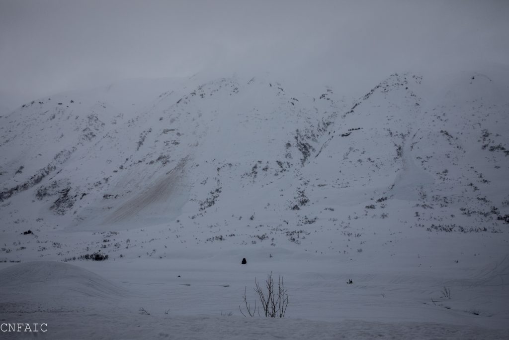
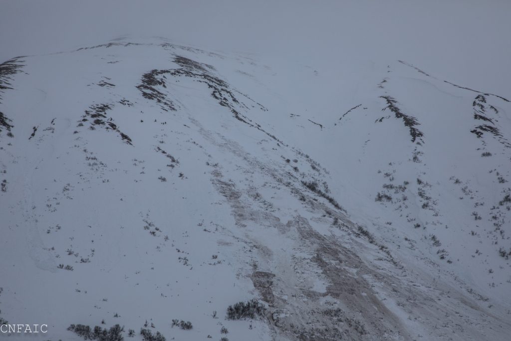
The avalanche danger will remain HIGH today for Turnagain Pass, Girdwood and Portage due to above freezing temperatures and the likelihood of natural wet slab avalanches below 3000′. In the alpine natural and human triggered storm slab 2-3′ deep are likely today and have the potential to step down into a very deep and dangerous avalanche. Travel in avalanche terrain is not recommended.

PORTAGE VALLEY: Travel in runout zones from avalanches including venturing along and past the Byron Glacier Trail continues to be not recommended. Very large avalanches have been observed in Portage over the past few days and are expected to continue today.

SUMMIT LAKE (& INTERIOR EASTERN KENAI MTS): Extra caution is advised. Large human triggered avalanches remain likely. Avalanches have the potential to release in old buried weak layers.

SEWARD/LOST LAKE: Warm temperatures, strong winds and a mix of rain and new snow have added more stress to the snowpack. Although less precipitation fell yesterday, triggering a large and dangerous avalanche is likely.

Special Announcements

20 years ago today, March 21, 1999 a massive avalanche took the lives of 6 snowmachiners on Seattle Ridge in Turnagain Pass. Our deepest condolences are with the family and friends of those lost that day. In commemoration, CNFAIC forecasters and Friends of CNFAIC, will be at the Turnagain Pass motorized lot on Saturday, March 23rd, from 12pm – 2pm. We welcome any and all to stop by for a hot dog, say hi, chat about the current avalanche conditions, and test your avalanche rescue gear. We’ll have a few beacons buried so you can practice your skills.  

Our thoughts are also with the family and friends of the skier killed in an avalanche on March 9th, 2019 near the Crescent Saddle Cabin. The detailed report can be found on our accidents page HERE. A big thank you to the backcountry partners involved in this accident for their willingness to share what happened so we can all learn.  

Heading to Hatcher Pass? Be sure to check out the Hatcher Pass Avalanche Center mid-week snow and avalanche summary HERE.  

Thu, March 21st, 2019
Alpine
Above 2,500'
4 - High
Avalanche risk
Treeline
1,000'-2,500'
4 - High
Avalanche risk
Below Treeline
Below 1,000'
4 - High
Avalanche risk
0 - No Rating
1 - Low
2 - Moderate
3 - Considerable
4 - High
5 - Extreme
Avalanche risk Avalanche risk Avalanche risk Avalanche risk Avalanche risk
Travel Advice Generally safe avalanche conditions. Watch for unstable snow on isolated terrain features. Heightened avalanche conditions on specific terrain features. Evaluate snow and terrain carefully; identify features of concern. Dangerous avalanche conditions. Careful snowpack evaluation, cautious route-finding, and conservative decision-making essential. Very dangerous avalanche conditions. Travel in avalanche terrain not recommended. Extraordinarily dangerous avalanche conditions. Avoid all avalanche terrain.
Likelihood of Avalanches Natural and human-triggered avalanches unlikely. Natural avalanches unlikely; human-triggered avalanches possible. Natural avalanches possible; human-triggered avalanches likely. Natural avalanches likely; human-triggered avalanches very likely. Natural and human-triggered avalanches certain.
Avalanche Size and Distribution Small avalanches in isolated areas or extreme terrain. Small avalanches in specific areas; or large avalanches in isolated areas. Small avalanches in many areas; or large avalanches in specific areas; or very large avalanches in isolated areas. Large avalanches in many areas; or very large avalanches in specific areas. Very large avalanches in many areas.
Avalanche Problem 1
  • Wet Slab
    Wet Slab
  • Certain
    Very Likely
    Likely
    Possible
    Unlikely
    Likelihood
  • Historic (D4-5)
    Very Large (D3)
    Large (D2)
    Small (D1)
    Size
Wet Slab
Wet Slab avalanches are the release of a cohesive layer of snow (a slab) that is generally moist or wet when the flow of liquid water weakens the bond between the slab and the surface below (snow or ground). They often occur during prolonged warming events and/or rain-on-snow events. Wet Slabs can be very unpredictable and destructive.

Likelihood of Avalanches
Terms such as "unlikely", "likely", and "certain" are used to define the scale, with the chance of triggering or observing avalanches increasing as we move up the scale. For our purposes, "Unlikely" means that few avalanches could be triggered in avalanche terrain and natural avalanches are not expected. "Certain" means that humans will be able to trigger avalanches on many slopes, and natural avalanches are expected.

Size of Avalanches
Avalanche size is defined by the largest potential avalanche, or expected range of sizes related to the problem in question. Assigned size is a qualitative estimate based on the destructive classification system and requires specialists to estimate the harm avalanches may cause to hypothetical objects located in the avalanche track (AAA 2016, CAA 2014). Under this schema, "Small" avalanches are not large enough to bury humans and are relatively harmless unless they carry people over cliffs or through trees or rocks. Moving up the scale, avalanches become "Large" enough to bury, injure, or kill people. "Very Large" avalanches may bury or destroy vehicles or houses, and "Historic" avalanches are massive events capable of altering the landscape.

Signal Word Size (D scale) Simple Descriptor
Small 1 Unlikely to bury a person
Large 2 Can bury a person
Very Large 3 Can destroy a house
Historic 4 & 5 Can destroy part or all of a village
More info at Avalanche.org

Over the last two weeks we’ve seen some big storms and some impressive avalanche activity. Yesterday was similar, except it arrived with very warm temperatures and heavy rain to ridgetops. In Turnagain Pass .9” of rain was recorded and in Girdwood (Alyeska midway) 2.74” of rain was recorded. This is a lot of water in short period of time, especially in Girdwood and the Northern side of Turnagain Pass. We estimate rain/snow line fluctuated between ~3000’and ~2500’. Ridge top winds were in the 40-60’s mph with a gust to 101mph on Sunburst. Numerous natural wet slabs were observed on Seattle Ridge by the afternoon and Portage Valley reached 50F. Temperatures have remained above freezing overnight at Seattle Ridge weather station (2400’) and overcast skies are keeping the snowpack insulated. This means the snow is still wet and saturated in the mid and lower elevations. Wet slab avalanches are not something to mess with. These are unpredictable and unsurvivable if someone was to get caught. Until temperatures drop below freezing and the snowpack has a chance to drain, we recommend avoiding avalanche terrain. To compound this situation another storm is expected to arrive late afternoon with another round of heavy rain and strong winds overnight.

Storm Slabs:
In the alpine, where 1-3’ of snow fell yesterday, storm slabs are expected to be unstable. Strong Easterly winds 25-40mph will continue throughout the day and will be adding stress to the upper elevation snow pack. Natural and human triggered storms slabs 2-3′ are likely where the snow is dry.

South of Turnagain in the Summit Lake and areas in the interior Kenai Peninsula have a very poor snow structure with variety of old weak layers (facets and buried surface hoar) in the mid and base of the snowpack. Not as much precipitation fell overnight, but temperatures remain very warm. Winds and warm temperatures will be adding stress to the snowpack today and triggering a dangerous slab avalanche 1-3’ thick remains likely in the alpine. Triggering a wet avalanche is likely below treeline. 

Natural wet slab avalanches on Seattle Ridge near the motorized lot yesterday afternoon. 


Natural wet slab avalanche entraining snow to the ground on Seattle Ridge, SE aspect, near Bertha Creek. 

Additional Concern
  • Glide Avalanches
    Glide Avalanches
Glide Avalanches
Glide Avalanches are the release of the entire snow cover as a result of gliding over the ground. Glide avalanches can be composed of wet, moist, or almost entirely dry snow. They typically occur in very specific paths, where the slope is steep enough and the ground surface is relatively smooth. They are often proceeded by full depth cracks (glide cracks), though the time between the appearance of a crack and an avalanche can vary between seconds and months. Glide avalanches are unlikely to be triggered by a person, are nearly impossible to forecast, and thus pose a hazard that is extremely difficult to manage.
More info at Avalanche.org

Several glide cracks have released in the last few days including one on Seattle Ridge yesterday. In Girdwood two were observed yesterday on Raggedtop and Penguin Ridge. Similar to wet slab avalanches these are very unpredictable and impossible to manage.

Glide avalanche on Seattle Ridge released yesterday, just North of the uptrack. 

Weather
Thu, March 21st, 2019

Yesterday: Temperatures increased into the 40Fs at sea level and mid 30Fs at ridgetops. Portage Valley hit 50F yesterday morning. Heavy rain fell below 3000′ most of the day. Turnagain pass recorded .9 € of rain. Alyeska midway recorded 2.76 € or rain and Bear Valley in Portage recorded 2.02 € of rain. Ridgetop winds were Easterly, 40-60 mph with gusts in the 70-80s. Overnight temperatures remained above freezing at 2400′ at Seattle Ridge weather Station with obscured skies.

Today: Rain will continue throughout the day and become heavy rain by this evening as another storm tracks through our region. Today 0.3 € rain is expected with 1 € of rain overnight. Temperature will remain in the 40Fs at sea level, mid 30Fs in the mid elevations. Rain/snow may drop a little by this evening to ~2000′. Strong Easterly ridgetop winds 30-40mph will continue today bumping into the 50-60’s by this evening.

Tomorrow: Skies will remain obscured, and rain is expected to continue through the day. Above freezing temperatures will continue in the lower and mid elevations. Strong winds will start to diminish by Saturday morning.

*Seattle Ridge weather station anemometer has been experiencing some issues and may be under reporting wind data.

PRECIPITATION 24-hour data (6am – 6am)

  Temp Avg (F) Snow (in) Water (in) Snow Depth (in)
Center Ridge (1880′)  39  rain 0.9   78  
Summit Lake (1400′)  41 rain   0.4    28
Alyeska Mid (1700′)  37 rain    2.74 73  

RIDGETOP 24-hour data (6am – 6am)

  Temp Avg (F) Wind Dir Wind Avg (mph) Wind Gust (mph)
Sunburst (3812′) 31   ENE   41   101  
Seattle Ridge (2400′) 35   *SE   *20   *50  
Observations
Recent Observations for Turnagain Pass
Date Region Location
04/16/24 Turnagain Observation: Cornbiscuit
04/15/24 Turnagain Observation: Taylor Pass
04/15/24 Turnagain Observation: Seward Highway – Tern Lake to Portage
04/14/24 Turnagain Observation: Sunburst
04/14/24 Turnagain Observation: Turnagain Pass Snomo
04/13/24 Turnagain Observation: Spokane Creek
04/11/24 Turnagain Observation: Tincan
04/10/24 Turnagain Avalanche: Seattle Ridge
04/10/24 Turnagain Observation: Cornbiscuit South Face
04/10/24 Turnagain Avalanche: Tincan
Riding Areas

The riding areas page has moved. Please click here & update your bookmarks.


Subscribe to Turnagain Pass
Avalanche Forecast by Email

This is a general backcountry avalanche advisory issued for Turnagain Arm with Turnagain Pass as the core advisory area. This advisory does not apply to highways, railroads or operating ski areas.