Turnagain Pass RSS

Archives
ARCHIVED - Forecasts expire after 24 hours.
Issued
Sun, January 27th, 2019 - 7:00AM
Expires
Mon, January 28th, 2019 - 7:00AM
Forecaster
Wendy Wagner
Avalanche risk The Bottom Line

The avalanche danger remains CONSIDERABLE on slopes above 1,500′.  Human triggered slab avalanches between 2 to 5 feet thick remain likely; nine avalanches were triggered yesterday.  These slabs can be triggered from the bottom, side or on top of a slope while traveling along a ridge. They have the potential to  be large, dangerous and unsurviveable.  Additionally, cornices may break farther back than expected and could trigger an avalanche below.  

*Cautious route-finding and conservative decision-making are essential again today.  A  SPECIAL AVALANCHE BULLETIN  remains in effect through the National Weather Service.  

SUMMIT LAKE / JOHNSON PASS:   Dangerous avalanche conditions exist in these regions south of Turnagain Pass. Strong wind, a poor snowpack structure and recent avalanche activity all point to an unstable snowpack.

Sun, January 27th, 2019
Alpine
Above 2,500'
3 - Considerable
Avalanche risk
Treeline
1,000'-2,500'
3 - Considerable
Avalanche risk
Below Treeline
Below 1,000'
1 - Low
Avalanche risk
0 - No Rating
1 - Low
2 - Moderate
3 - Considerable
4 - High
5 - Extreme
Avalanche risk Avalanche risk Avalanche risk Avalanche risk Avalanche risk
Travel Advice Generally safe avalanche conditions. Watch for unstable snow on isolated terrain features. Heightened avalanche conditions on specific terrain features. Evaluate snow and terrain carefully; identify features of concern. Dangerous avalanche conditions. Careful snowpack evaluation, cautious route-finding, and conservative decision-making essential. Very dangerous avalanche conditions. Travel in avalanche terrain not recommended. Extraordinarily dangerous avalanche conditions. Avoid all avalanche terrain.
Likelihood of Avalanches Natural and human-triggered avalanches unlikely. Natural avalanches unlikely; human-triggered avalanches possible. Natural avalanches possible; human-triggered avalanches likely. Natural avalanches likely; human-triggered avalanches very likely. Natural and human-triggered avalanches certain.
Avalanche Size and Distribution Small avalanches in isolated areas or extreme terrain. Small avalanches in specific areas; or large avalanches in isolated areas. Small avalanches in many areas; or large avalanches in specific areas; or very large avalanches in isolated areas. Large avalanches in many areas; or very large avalanches in specific areas. Very large avalanches in many areas.
Avalanche Problem 1
  • Persistent Slabs
    Persistent Slabs
  • Certain
    Very Likely
    Likely
    Possible
    Unlikely
    Likelihood
  • Historic (D4-5)
    Very Large (D3)
    Large (D2)
    Small (D1)
    Size
Persistent Slabs
Persistent Slab avalanches are the release of a cohesive layer of snow (a slab) in the middle to upper snowpack, when the bond to an underlying persistent weak layer breaks. Persistent layers include: surface hoar, depth hoar, near-surface facets, or faceted snow. Persistent weak layers can continue to produce avalanches for days, weeks or even months, making them especially dangerous and tricky. As additional snow and wind events build a thicker slab on top of the persistent weak layer, this avalanche problem may develop into a Deep Persistent Slab.

Likelihood of Avalanches
Terms such as "unlikely", "likely", and "certain" are used to define the scale, with the chance of triggering or observing avalanches increasing as we move up the scale. For our purposes, "Unlikely" means that few avalanches could be triggered in avalanche terrain and natural avalanches are not expected. "Certain" means that humans will be able to trigger avalanches on many slopes, and natural avalanches are expected.

Size of Avalanches
Avalanche size is defined by the largest potential avalanche, or expected range of sizes related to the problem in question. Assigned size is a qualitative estimate based on the destructive classification system and requires specialists to estimate the harm avalanches may cause to hypothetical objects located in the avalanche track (AAA 2016, CAA 2014). Under this schema, "Small" avalanches are not large enough to bury humans and are relatively harmless unless they carry people over cliffs or through trees or rocks. Moving up the scale, avalanches become "Large" enough to bury, injure, or kill people. "Very Large" avalanches may bury or destroy vehicles or houses, and "Historic" avalanches are massive events capable of altering the landscape.

Signal Word Size (D scale) Simple Descriptor
Small 1 Unlikely to bury a person
Large 2 Can bury a person
Very Large 3 Can destroy a house
Historic 4 & 5 Can destroy part or all of a village
More info at Avalanche.org

Yesterday was an interesting day in the mountains. The snowpack proved to be highly unstable and there were 9 confirmed human triggered avalanches. These were all on the back side of Seattle Ridge. Four of them I was able to witness. These four were along Main Bowl (1st Bowl) and were triggered by two snowmachiners traveling along the ridge; releasing the avalanches one after another while they moved along. The ridge is so broad they could not see the slope below and had no idea they were triggering these slides. To our knowledge, there was no one caught in any slides yesterday. 

Most, if not all, of the avalanches triggered were triggered remotely. This means triggered by a person not on the slope, but instead on the ridge above, to the side or at the bottom. The snowpack is set-up exactly for this situation and we can expect remote triggered avalanches as we move forward. The scary thing is, this set-up can allow someone to inadvertently trigger an avalanche onto themselves from below or onto someone else from a safe location. Something for all of us to keep in mind.

The problem is last week’s storm snow fell onto a layer of surface hoar (we are now calling the MLK or 1/21 buried surface hoar). This is a persistent weak layer which is inhibiting bonding between the new and old snow and creating our dangerous snowpack structure. How deep the weak layer and subsequent avalanche will be is dependent upon how much snow fell in that zone. The avalanches yesterday were generally 18″ to 3′ thick. Although yesterday’s activity was all between 2,000 and 3,000′, we saw no evidence or anyone traveling in the higher elevations testing those slopes. Hence, all elevations above 1,500′ should be suspect. Points to keep in mind if headed out today:

1-  The snowpack will be just as touchy, we need to know what is and isn’t avalanche terrain before heading out
2-  The snowpack will be slow to adjust/stabilize with this notorious persistent weak layer 
2-  No obvious signs of instability may be seen, yet avalanches could release easily and remotely
3-  Sticking to lower angle slopes (less than 30 degrees) with nothing steeper above is a great way to avoid these avalanche concerns


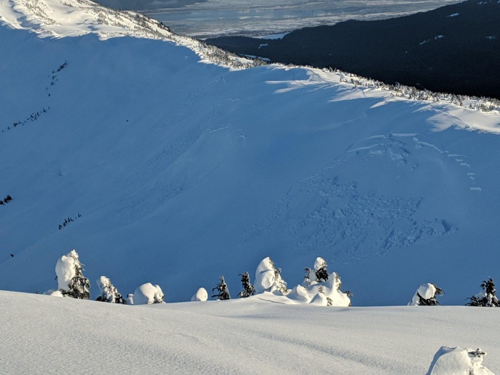
Slab avalanches in Main Bowl (1st Bowl) triggered remotely by riders moving along ridge. 


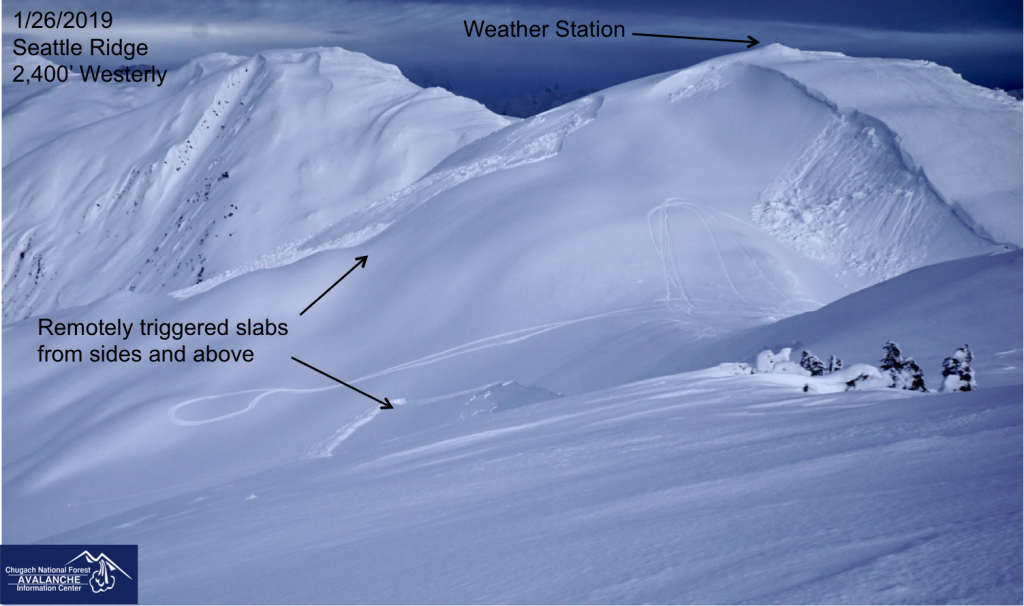
Two slabs triggered remotely by riders along with a cornice break. The slab on the top of the photo is quite thick, up to 5′ at the crown. This area is between Main and Jr’s Bowl (1st and 2nd Bowl) Thanks to these folks for clearing off the weather station!


Snowpack structure at 2,300′, West aspect along Seattle Ridge. Clearly seen is the ‘thin gray line’ of the 1/21 (MLK) buried surface hoar.


Video linked HERE.


South of Turnagain – Johnson Pass/Summit Lake zone: poor snowpack structure exists in these areas.  Multiple mid-pack weak layers of facets and buried surface hoar have been found as well as a facet/crust combination in the bottom of the snowpack. See the video below (link HERE) as Don Sharaf shows the recent weak layer reacting as well as an older weak layer. Avalanches triggered in this area could step down into deeper layers creating a much larger avalanche. Although this region received less snow (6-12″) last week, the snowpack is still very dangerous. 

    
Don Sharaf with the American Avalanche Institute performs an Extended Column Test in the Silvertip area south of Turnagain Pass. A big thanks to the AAS/AAI Pro 2 avalanche course for their information this week.

Avalanche Problem 2
  • Cornice
    Cornice
  • Certain
    Very Likely
    Likely
    Possible
    Unlikely
    Likelihood
  • Historic (D4-5)
    Very Large (D3)
    Large (D2)
    Small (D1)
    Size
Cornice
Cornice Fall is the release of an overhanging mass of snow that forms as the wind moves snow over a sharp terrain feature, such as a ridge, and deposits snow on the downwind (leeward) side. Cornices range in size from small wind drifts of soft snow to large overhangs of hard snow that are 30 feet (10 meters) or taller. They can break off the terrain suddenly and pull back onto the ridge top and catch people by surprise even on the flat ground above the slope. Even small cornices can have enough mass to be destructive and deadly. Cornice Fall can entrain loose surface snow or trigger slab avalanches.

Likelihood of Avalanches
Terms such as "unlikely", "likely", and "certain" are used to define the scale, with the chance of triggering or observing avalanches increasing as we move up the scale. For our purposes, "Unlikely" means that few avalanches could be triggered in avalanche terrain and natural avalanches are not expected. "Certain" means that humans will be able to trigger avalanches on many slopes, and natural avalanches are expected.

Size of Avalanches
Avalanche size is defined by the largest potential avalanche, or expected range of sizes related to the problem in question. Assigned size is a qualitative estimate based on the destructive classification system and requires specialists to estimate the harm avalanches may cause to hypothetical objects located in the avalanche track (AAA 2016, CAA 2014). Under this schema, "Small" avalanches are not large enough to bury humans and are relatively harmless unless they carry people over cliffs or through trees or rocks. Moving up the scale, avalanches become "Large" enough to bury, injure, or kill people. "Very Large" avalanches may bury or destroy vehicles or houses, and "Historic" avalanches are massive events capable of altering the landscape.

Signal Word Size (D scale) Simple Descriptor
Small 1 Unlikely to bury a person
Large 2 Can bury a person
Very Large 3 Can destroy a house
Historic 4 & 5 Can destroy part or all of a village
More info at Avalanche.org

Cornices have grown and may still be quite tender and teetering on the brink of failure. Give them a wide berth from above and limit exposure underneath them. Any cornice fall is not only dangerous itself, but is likely to trigger a slab avalanche below. 

Weather
Sun, January 27th, 2019

Yesterday:   Mostly clear to partly cloudy skies were over the region. Ridgetop winds were light from the east and bumped up slightly to the 15-20mph range overnight. Temperatures have been near 30F at sea level and the lower elevations, while ridgetops have remained near 20F.  

Today:   Mostly cloudy skies are expected today with a chance for a few snow flurries. Up to an inch of snow could fall tonight. Ridgetop winds are slated to keep climbing and reach the 20-30mph range this afternoon from the east. Temperatures look to remain near 30F at the lower elevations and near 20F along ridgelines.

Tomorrow:   Cloudy skies, increased easterly winds and a chance for a few inches of snow is on tap. Temperatures should remain cool enough for snow to sea level.  

*Seattle Ridge weather station was heavily rimed and the anemometer (wind sensor) was destroyed. We are currently working to replace it.

PRECIPITATION 24-hour data (6am – 6am)

  Temp Avg (F) Snow (in) Water (in) Snow Depth (in)
Center Ridge (1880′) 27   0   0   59  
Summit Lake (1400′) 20   0   0   20  
Alyeska Mid (1700′) 28   0   0   44  

RIDGETOP 24-hour data (6am – 6am)

  Temp Avg (F) Wind Dir Wind Avg (mph) Wind Gust (mph)
Sunburst (3812′) 21   ESE    9 28  
Seattle Ridge (2400′) 25   *N/A   *N/A     *N/A    
Observations
Recent Observations for Turnagain Pass
Date Region Location
10/27/24 Turnagain Observation: Tincan
10/21/24 Turnagain Observation: Turnagain Pass Road Observation
10/19/24 Turnagain Observation: Tincan – Below Todds Run
10/18/24 Turnagain Observation: Taylor Pass
10/15/24 Turnagain Observation: Tincan Common
10/14/24 Turnagain Avalanche: Tincan
05/13/24 Turnagain Observation: Eddie’s, Sunburst, Seattle, Cornbiscuit, Pete’s South
05/13/24 Turnagain Observation: Turnagain Pass non-motorized side
05/12/24 Turnagain Observation: Warm up Bowl
05/07/24 Turnagain Observation: Turnagain Pass Wet Slabs
Riding Areas

The riding areas page has moved. Please click here & update your bookmarks.


Subscribe to Turnagain Pass
Avalanche Forecast by Email

This is a general backcountry avalanche advisory issued for Turnagain Arm with Turnagain Pass as the core advisory area. This advisory does not apply to highways, railroads or operating ski areas.