Turnagain Pass Avalanche Forecast
|
![]() ![]() |
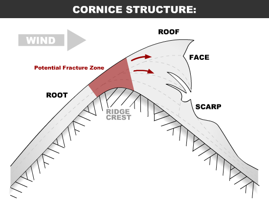
There is a MODERATE avalanche danger for slopes above 1,000′. Triggering a cornice fall or a wind slab avalanche will be possible in areas exposed to Saturday’s winds. Glide cracks are opening and could release at anytime, avoid travel under them.
JOHNSON PASS / LYNX DRAINAGE / SUMMIT LAKE: South of Turnagain Pass weak layers exists under 2-3′ of snow. Human triggered slab avalanches over 2′ thick are possible on slopes over 35 degrees. We are currently gathering information from these areas. Please consider submitting an observation if you head there – thank you!
LOST LAKE: This zone is out of the advisory area, but is also suspect for harboring weak layers 2-3′ below the snow surface due to recent reports. Triggering large slab avalanche should be on the radar here as well. Pay attention for signs of instability like collapsing and recent avalanches.
Signal Word | Size (D scale) | Simple Descriptor |
Small | 1 | Unlikely to bury a person |
Large | 2 | Can bury a person |
Very Large | 3 | Can destroy a house |
Historic | 4 & 5 | Can destroy part or all of a village |
We received multiple reports of cornice falls being triggered yesterday. One was triggered by two snowmachiners walking out too far onto the Warm-up Bowl corniced ridge. From what we know one person went down with the cornice chunks but was ok. Another cornice fall was triggered skinning along the Tincan ridge towards Tincan Proper and one was dog triggered along the Sunburst ridge. Luckily no one was injured in these and the cornice falls did not trigger avalanches on the slopes below. Remember to give cornices a wide berth on the ridge as they can break off further back than expected and potentially take you for a nasty ride. They could also trigger a wind slab or larger avalanche below, creating an even bigger problem. It is also important to limit exposure time below them especially with so many people out enjoying the snow this holiday week.
WIND SLABS: Saturday’s sustained NE winds that were strong enough to move snow around and form cornices also potentially created wind slabs on steep, unsupported slopes. There were reports of observers yesterday finding small pockets of wind slab. Continue to be on the lookout for these today. At this point they may be stubborn and could allow a person well out onto them before releasing. Watch for shooting cracks, hollow sounding snow and be especially aware of the terrain – if a wind slab or cornice does release where will you go?
Cornice fall triggered skinning along Tincan Ridge towards Tican Proper, 12-23-18. Photos: Owen Smith
Cornice diagram from the Avalanche.org encyclopedia. Note the potential fracture zone on the ridge.
Signal Word | Size (D scale) | Simple Descriptor |
Small | 1 | Unlikely to bury a person |
Large | 2 | Can bury a person |
Very Large | 3 | Can destroy a house |
Historic | 4 & 5 | Can destroy part or all of a village |
Buried weak layers roughly 2′ below the snow surface have been found in areas south of Turnagain Pass in both the Summit Lake zone and as far south as Lost Lake. We suspect the snowpack may be similar around Johnson Pass, Lynx drainage and Twin Peaks/Silver Tip. These weak layers are composed of facets associated with crusts and have been showing signs they could be reactive enough a person could trigger a large avalanche. If you are headed to areas south of Turnagain, keep in mind triggering a large slab avalanche is possible. Listen and feel for whumpfing (collapsing of the snowpack) and look for avalanche activity from the storm that may have steeped down into the deeper layers.
Slab avalanches just south of Turnagain Pass that occurred during the Solstice Sleeper Storm believed to have released on the crust/facet set-up. 12-20-18
Watch for opening glide cracks. These are likely to be oozing down the slopes with all the new snow weighing the snowpack down. Glide avalanches can release at any time and are not associated with human triggers. It’s a case of not wanting to be in the wrong place at the wrong time. There are glide cracks are opening up on the SW faces of Tincan and Sunburst as well as the Johnson Pass area and Gold Pan in upper Bertha Creek.
Glide cracks and cornices in Gold Pan, 12-23-18. Photo: Peter Biskind.
Yesterday: Skies were clear with some valley fog. Temperatures were in the 20Fs and winds were light. Overnight temperatures were in the teens and low 20Fs. Winds remained light.
Today: Skies will be partly sunny with temperatures staying in the teens to low 20Fs and winds continue to be light. Temperatures drop into the low teens overnight.
Tomorrow: Skies will be cloudy, temperatures will be in the high 20Fs and there is a chance of Christmas snow showers as a front moves into the area. We are paying attention to the next series of lows developing that may impact the region later in the week! Stay tuned.
*Seattle Ridge weather station is rimed over and not recording any data.
Temp Avg (F) | Snow (in) | Water (in) | Snow Depth (in) | |
Center Ridge (1880′) | 24 | 0 | 0 | 61 |
Summit Lake (1400′) | 18 | 0 | 0 |
13 |
Alyeska Mid (1700′) | 24 | 0 | 0 | 33 |
Temp Avg (F) | Wind Dir | Wind Avg (mph) | Wind Gust (mph) | |
Sunburst (3812′) | 24 | SE | 4 | 14 |
Seattle Ridge (2400′) | *N/A | *N/A | *N/A | *N/A |
Date | Region | Location | Observer |
---|---|---|---|
05/22/23 | Turnagain | Avalanche: Tincan | Nick D'Alessio |
05/12/23 | Turnagain | Avalanche: Tincan, Sunburst, Magnum, Cornbiscuit | Heather Thamm |
05/07/23 | Turnagain | Observation: Tincan – Bear Tracks | CNFAIC Staff |
05/05/23 | Turnagain | Observation: Seattle Ridge | AS/ WW Forecaster |
05/02/23 | Turnagain | Observation: Cornbiscuit | Schauer/ Sturgess Forecaster |
05/02/23 | Turnagain | Observation: Seward Hwy Turnagain Pass | Joel Curtis |
04/30/23 | Turnagain | Observation: Magnum | Ayla, Kit Crosby, Barton |
04/29/23 | Turnagain | Observation: Tincan | John Sykes |
04/28/23 | Turnagain | Avalanche: Taylor Pass/Pastoral | Schauer/ Creighton Forecaster |
04/28/23 | Turnagain | Avalanche: Tincan | Andy Moderow |
Status of riding areas across the Chugach NF is managed by the Glacier and Seward Ranger Districts, not avalanche center staff. Riding area information is posted as a public service to our users and updated based on snow depth and snow density to prevent resource damage at trailhead locations. Riding area questions contact: mailroom_r10_chugach@fs.fed.us
Area | Status | Weather & Riding Conditions |
---|---|---|
Glacier District |
Subscribe to Turnagain Pass
Avalanche Forecast by Email
This is a general backcountry avalanche advisory issued for Turnagain Arm with Turnagain Pass as the core advisory area. This advisory does not apply to highways, railroads or operating ski areas.