Turnagain Pass Avalanche Forecast RSS

Archives
ARCHIVED FORECAST - All forecasts expire after 24 hours from the posting date/time.
Issued
Sat, December 8th, 2018 - 7:00AM
Expires
Sun, December 9th, 2018 - 7:00AM
Forecaster
Wendy Wagner
Avalanche risk The Bottom Line

Travel is not recommended in avalanche terrain again today as a  HIGH  avalanche danger remains. Large natural avalanches are likely in the upper elevations as snowfall and winds continue. Wet avalanches are likely in the mid elevations and in channeled terrain below treeline.

PORTAGE:    Up to 5′ of snow has fallen in the high elevations, avalanches are still likely to run their full length to valley bottoms. Avoid being in avalanche paths.

SUMMIT LAKE:    A  very weak and shallow snowpack exists under the storm snow. Slab avalanches 1+’ deep will be very easy to trigger and may release naturally on steeper slopes.

Special Announcements
  • Looking for avalanche courses or evening presentations? Check out our  calendar page! There are two CNFAIC evening discussions coming up – these are FREE and a great way to get your head back in the avalanche game.  
Thanks to our sponsors!
Sat, December 8th, 2018
Alpine
Above 2,500'
High (4)
Avalanche risk
Treeline
1,000'-2,500'
High (4)
Avalanche risk
Below Treeline
Below 1,000'
Considerable (3)
Avalanche risk
Alpine
Above 2,500'
Avalanche risk
High (4)
Treeline
1,000'-2,500'
Avalanche risk
High (4)
Below Treeline
Below 1,000'
Avalanche risk
Considerable (3)
Danger Scale:
No Rating (0)
Low (1)
Moderate (2)
Considerable (3)
High (4)
Extreme (5)
Avalanche Problem 1
  • Storm Slabs
    Storm Slabs
  • Almost Certain
    Very Likely
    Likely
    Possible
    Unlikely
    Likelihood
  • Historic (D4-5)
    Very Large (D3)
    Large (D2)
    Small (D1)
    Size
Storm Slabs
Storm Slab avalanches are the release of a cohesive layer (a slab) of new snow that breaks within new snow or on the old snow surface. Storm-slabs typically last between a few hours and few days (following snowfall). Storm-slabs that form over a persistent weak layer (surface hoar, depth hoar, or near-surface facets) may be termed Persistent Slabs or may develop into Persistent Slabs.

Likelihood of Avalanches
Terms such as "unlikely", "likely", and "certain" are used to define the scale, with the chance of triggering or observing avalanches increasing as we move up the scale. For our purposes, "Unlikely" means that few avalanches could be triggered in avalanche terrain and natural avalanches are not expected. "Certain" means that humans will be able to trigger avalanches on many slopes, and natural avalanches are expected.

Size of Avalanches
Avalanche size is defined by the largest potential avalanche, or expected range of sizes related to the problem in question. Assigned size is a qualitative estimate based on the destructive classification system and requires specialists to estimate the harm avalanches may cause to hypothetical objects located in the avalanche track (AAA 2016, CAA 2014). Under this schema, "Small" avalanches are not large enough to bury humans and are relatively harmless unless they carry people over cliffs or through trees or rocks. Moving up the scale, avalanches become "Large" enough to bury, injure, or kill people. "Very Large" avalanches may bury or destroy vehicles or houses, and "Historic" avalanches are massive events capable of altering the landscape.

Signal Word Size (D scale) Simple Descriptor
Small 1 Unlikely to bury a person
Large 2 Can bury a person
Very Large 3 Can destroy a house
Historic 4 & 5 Can destroy part or all of a village
More info at Avalanche.org

Yesterday’s quick moving and powerful storm brought feet of snow to the Alpine, inches of rain to sea level and 90mph winds to the ridgetops. The rain snow line bounced between 1,000′ and 1,500′ in most areas. Mostly wet snow and rain fell along Turnagain Pass and as of this morning, there is what looks to be an inch or two of snow surviving along the Pass. Rain and snowfall have decreased overnight but are on tap to pick up slightly again this evening. 

Storm totals at the mid-elevation snow stations (beginning Thursday night to 6am this morning)

  • Turnagain Pass at 1,880′:  1.5-2″ of water equivalent, roughly 1.5-2′ of snow above treeline
  • Girdwood Valley at 1,700′:  2.7″ of water equivalent, roughly 2-3′ above treeline
  • Summit Lake at 1,400′: 0.7″ of water equivalent (rain/snow mix along the road at Summit Pass), roughly 6-8″ of snow above treeline

Widespread avalanche activity was seen yesterday. Debris piles were observed running into snow free zones below 1,000′ in Girdwood and Portage Valleys as well as Seward. Although natural activity will be expected to decrease today, the mountains are still in shock and large avalanches are still likely in many areas. With additional snowfall tonight, natural avalanche likelihood could increase again. That said, today is another day to avoid avalanche terrain all together.  

Moose Mountain avalanches, outline of debris marked in orange. This is near MP 52 along the Seward Highway (Summit zone). Photo: Alex McLain


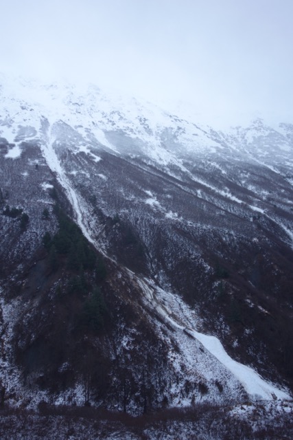
Upper Girdwood Valley, North side of Crow Creek Valley. Debris from avalanches above running to valley floor.


Seward’s Mt. Benson with several large debris piles from avalanche activity higher on the mountain. Photo: Jamie Lyons


Just enough snow to make it white along Turnagain Pass yesterday. This is Rookie Hill in the foreground looking at the base of Seattle Ridge, seen from the motorized parking lot. Photo: Will Brennen

Weather
Sat, December 8th, 2018

Yesterday:   Heavy rain below 1,000′ and heavy snowfall above 1,500′ – a wintery mix in between these elevations. Snow and water totals above and below. Winds were strong out of the East, averaging in the 60’s mph with gusts into the 90’s. Temperatures were in the upper 20’s along the ridgetops and mid 30’s at 1,000′.  

Today:   Rain and snowfall has decreased overnight. Scattered showers should be seen around the region today and could pick up slightly tonight. Between .2-.3″ of rain below 1,000′ is forecast with 2-4″ of additional snow at the higher elevations today. Tonight snow line should lower and an additional 3-5″ of snow could be seen near sea level by tomorrow morning.   Ridgetop winds will continue from the east in the 25-30 mph range. Temperatures will be in the low 30’s at 1,000′ and mid 20’s along ridgelines through the day.  

Tomorrow:    Snowfall making its way to sea level will hopefully greet us in the morning as snow lines are forecast to lower. Snowfall should taper off by tomorrow morning bringing a break in storms before yet another wave of snow (and possibly rain at sea level) ushers in later on Sunday. Stay tuned!

*Seattle Ridge anemometer (wind sensor) reading uncommon wind direction during height of storm yesterday. Sensor is now rimed back over.  

PRECIPITATION 24-hour data (6am – 6am)

  Temp Avg (F) Snow (in) Water (in) Snow Depth (in)
Center Ridge (1880′) 33   14   1   30  
Summit Lake (1400′) 34   0   0.4   4  
Alyeska Mid (1700′) 33   2   1.92 4  

RIDGETOP 24-hour data (6am – 6am)

  Temp Avg (F) Wind Dir Wind Avg (mph) Wind Gust (mph)
Sunburst (3812′) 26   NE   41   98!  
Seattle Ridge (2400′) 30   *WNW *25 66  
Observations
Recent Observations for Turnagain Pass
Date Region Location
05/22/23 Turnagain Avalanche: Tincan
05/12/23 Turnagain Avalanche: Tincan, Sunburst, Magnum, Cornbiscuit
05/07/23 Turnagain Observation: Tincan – Bear Tracks
05/05/23 Turnagain Observation: Seattle Ridge
05/02/23 Turnagain Observation: Cornbiscuit
05/02/23 Turnagain Observation: Seward Hwy Turnagain Pass
04/30/23 Turnagain Observation: Magnum
04/29/23 Turnagain Observation: Tincan
04/28/23 Turnagain Avalanche: Taylor Pass/Pastoral
04/28/23 Turnagain Avalanche: Tincan
Riding Areas
Updated Thu, June 01st, 2023

Status of riding areas across the Chugach NF is managed by the Glacier and Seward Ranger Districts, not avalanche center staff. Riding area information is posted as a public service to our users and updated based on snow depth and snow density to prevent resource damage at trailhead locations. Riding area questions contact: mailroom_r10_chugach@fs.fed.us

Area Status Weather & Riding Conditions
Glacier District
Johnson Pass
Closed
Closed May 15.
Placer River
Closed
Closed May 15.
Skookum Drainage
Closed
Will close to motorized use on April 1, 2023 per the National Forest Plan.
Turnagain Pass
Closed
Will close on June 1.
Twentymile
Closed
Scheduled closure May 1.
Seward District
Carter Lake
Closed
Scheduled closure May 1.
Lost Lake Trail
Closed
Scheduled closure May 1.
Primrose Trail
Closed
Scheduled closure May 1.
Resurrection Pass Trail
Closed
Closed to motorized use for the 2022/23 winter season per Forest Plan. Open next season.
Snug Harbor
Closed
Extended opening until May 15.
South Fork Snow River Corridor
Closed
Scheduled closure May 1.
Summit Lake
Closed
Scheduled closure May 1.

Subscribe to Turnagain Pass
Avalanche Forecast by Email

This is a general backcountry avalanche advisory issued for Turnagain Arm with Turnagain Pass as the core advisory area. This advisory does not apply to highways, railroads or operating ski areas.