Turnagain Pass Avalanche Forecast RSS

Archives
ARCHIVED FORECAST - All forecasts expire after 24 hours from the posting date/time.
Issued
Fri, April 13th, 2018 - 7:00AM
Expires
Sat, April 14th, 2018 - 7:00AM
Forecaster
Wendy Wagner
Avalanche risk The Bottom Line

The avalanche danger is LOW this morning and will rise to  MODERATE  today for wet avalanches on sunlit slopes. If there are slopes that did not have a solid re-freeze last night, natural wet avalanches are possible and the danger could rise to CONSIDERABLE.    In the Alpine, triggering a slab avalanche around a foot thick remains possible where drier snow exists. Give cornices a wide berth.

Special Announcements

Not only is the snow going through a springtime transition, the Avalanche Center is as well. It’s that time to work on Annual Reports, end of season details and prepare for next season.  Beginning next week, we will issue forecasts 4 days/wk on Sat, Sun, Tue, Thur. The final forecast will be on April 28th. The final Summit Summary of the year will be this Saturday.  

Thanks to our sponsors!
Fri, April 13th, 2018
Alpine
Above 2,500'
Moderate (2)
Avalanche risk
Treeline
1,000'-2,500'
Moderate (2)
Avalanche risk
Below Treeline
Below 1,000'
Moderate (2)
Avalanche risk
Alpine
Above 2,500'
Avalanche risk
Moderate (2)
Treeline
1,000'-2,500'
Avalanche risk
Moderate (2)
Below Treeline
Below 1,000'
Avalanche risk
Moderate (2)
Danger Scale:
No Rating (0)
Low (1)
Moderate (2)
Considerable (3)
High (4)
Extreme (5)
Avalanche Problem 1
  • Wet Loose
    Wet Loose
  • Almost Certain
    Very Likely
    Likely
    Possible
    Unlikely
    Likelihood
  • Historic (D4-5)
    Very Large (D3)
    Large (D2)
    Small (D1)
    Size
Wet Loose
Wet Loose avalanches are the release of wet unconsolidated snow or slush. These avalanches typically occur within layers of wet snow near the surface of the snowpack, but they may quickly gouge into lower snowpack layers. Like Loose Dry Avalanches, they start at a point and entrain snow as they move downhill, forming a fan-shaped avalanche. Other names for loose-wet avalanches include point-release avalanches or sluffs. Loose Wet avalanches can trigger slab avalanches that break into deeper snow layers.

Likelihood of Avalanches
Terms such as "unlikely", "likely", and "certain" are used to define the scale, with the chance of triggering or observing avalanches increasing as we move up the scale. For our purposes, "Unlikely" means that few avalanches could be triggered in avalanche terrain and natural avalanches are not expected. "Certain" means that humans will be able to trigger avalanches on many slopes, and natural avalanches are expected.

Size of Avalanches
Avalanche size is defined by the largest potential avalanche, or expected range of sizes related to the problem in question. Assigned size is a qualitative estimate based on the destructive classification system and requires specialists to estimate the harm avalanches may cause to hypothetical objects located in the avalanche track (AAA 2016, CAA 2014). Under this schema, "Small" avalanches are not large enough to bury humans and are relatively harmless unless they carry people over cliffs or through trees or rocks. Moving up the scale, avalanches become "Large" enough to bury, injure, or kill people. "Very Large" avalanches may bury or destroy vehicles or houses, and "Historic" avalanches are massive events capable of altering the landscape.

Signal Word Size (D scale) Simple Descriptor
Small 1 Unlikely to bury a person
Large 2 Can bury a person
Very Large 3 Can destroy a house
Historic 4 & 5 Can destroy part or all of a village
More info at Avalanche.org

The snowpack is heating up and beginning to slide off the mountain sides. Not everywhere, but the usual suspects have seen large wet avalanches over the past couple days, with the majority of the activity two days ago on Wednesday. Pyramid’s West face and the Southeast facing aspects of Seattle Ridge are these suspects and true to tradition, these slopes have seen the majority of the action. Although we have likely gone through the peak of acitivity for this first ‘warm-up’, any steep slope with a more shallow snowpack and baking in the sun is a concern for a naturally occurring large wet avalanche. 

For those headed out today, and this weekend, timing is everything. This morning, it’s likely that the wet surface snow has undergone a fairly solid re-freeze and the avalanche danger is LOW. As the day heats up and the crusts melt and lose strength, the danger rises. This is when wet avalanches can begin to release, either naturally or by a person. Remember solar noon is around 2pm so the snowpack is the warmest, and most dangerous, from ~1pm till ~5pm. Once snow becomes wet and ‘mushy’ up to you boot top, or your track starts trenching in wet snow, it’s time to head to a more supportable surface. Even a small wet avalanche can turn into something larger in bigger terrain. 

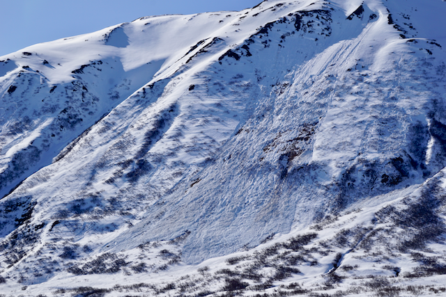
Photo below is on one example of the many large wet loose/wet slab avalanches on the Southeast face of Seattle Ridge occurring Wednesday.


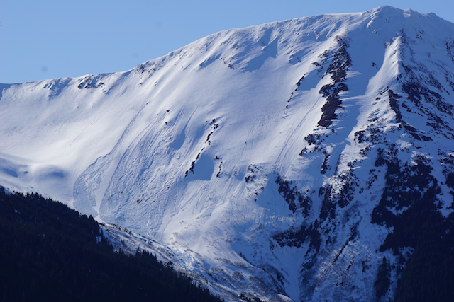
Wider angle view of Seattle Ridge and the many large wet avalanches from Wednesday.


Large wet loose slides from Tuesday on the East face of Pyramid.


The West face of Pyramid continues to shed its snowcover as the days go by. Note the slabs on the lower looker’s left of photo – these occurred sometime Wednesday evening/Thurs morning.


Avalanche Problem 2
  • Storm Slabs
    Storm Slabs
  • Almost Certain
    Very Likely
    Likely
    Possible
    Unlikely
    Likelihood
  • Historic (D4-5)
    Very Large (D3)
    Large (D2)
    Small (D1)
    Size
Storm Slabs
Storm Slab avalanches are the release of a cohesive layer (a slab) of new snow that breaks within new snow or on the old snow surface. Storm-slabs typically last between a few hours and few days (following snowfall). Storm-slabs that form over a persistent weak layer (surface hoar, depth hoar, or near-surface facets) may be termed Persistent Slabs or may develop into Persistent Slabs.

Likelihood of Avalanches
Terms such as "unlikely", "likely", and "certain" are used to define the scale, with the chance of triggering or observing avalanches increasing as we move up the scale. For our purposes, "Unlikely" means that few avalanches could be triggered in avalanche terrain and natural avalanches are not expected. "Certain" means that humans will be able to trigger avalanches on many slopes, and natural avalanches are expected.

Size of Avalanches
Avalanche size is defined by the largest potential avalanche, or expected range of sizes related to the problem in question. Assigned size is a qualitative estimate based on the destructive classification system and requires specialists to estimate the harm avalanches may cause to hypothetical objects located in the avalanche track (AAA 2016, CAA 2014). Under this schema, "Small" avalanches are not large enough to bury humans and are relatively harmless unless they carry people over cliffs or through trees or rocks. Moving up the scale, avalanches become "Large" enough to bury, injure, or kill people. "Very Large" avalanches may bury or destroy vehicles or houses, and "Historic" avalanches are massive events capable of altering the landscape.

Signal Word Size (D scale) Simple Descriptor
Small 1 Unlikely to bury a person
Large 2 Can bury a person
Very Large 3 Can destroy a house
Historic 4 & 5 Can destroy part or all of a village
More info at Avalanche.org

Triggering a dry(ish) slab avalanche is still possible and occurred yesterday. A skier was caught and carried in a slab around a foot deep in the Johnson Pass zone. Skier was ok. This slope was at 4,900′ on a West aspect. 

Upper elevation zones (above 3,500′) received up to a foot of new snow on Tues/Wed this week while light rain fell down low. This 8-12″ of snow is sitting on predominantly sun crust on E, S and West aspects. If you are in these higher elevation areas, such as near Whittier, Bench Peak, etc., watch for any new snow to become moist and possibly slide on the slick sun crust underneath. Hence, triggering a dry slab avalanche is still possible at the upper elevations. 

Weather
Fri, April 13th, 2018

Yesterday, sunny skies with light Easterly winds were over the region. Temperatures climbed to the low 50’sF at 1,000′ and to the upper 30’sF along the higher ridgelines at 4,000′. Overnight, a few clouds have moved in and temperatures have dropped to the 30’sF across the board – from ridgetops to sea level.  

For today, most sunny skies and another warm day are forecast. Temperatures should again reach 50F at 1,000′ at Turnagain Pass, mid 50’sF at sea level and just under 40F along ridgelines. Ridgetop winds will remain light (5-10mph) from the East before slowly shifting Northerly by tonight.  

For the weekend, sunny and blue skies will be over the region. Ridgetop winds at this time are expected to be light and Northerly bringing in slightly cooler air. Temperatures should be on a textbook durnal trend with cooling overnight and warming during the day. Models are suggesting the possibility for light rain Monday into Tuesday associated with a low-pressure developing near the Aleutians.  

PRECIPITATION 24-hour data (6am – 6am)

  Temp Avg (F) Snow (in) Water (in) Snow Depth (in)
Center Ridge (1880′) 40   0    0 69  
Summit Lake (1400′) 42   0   0   25  
Alyeska Mid (1700′) 41   0   0   66  

RIDGETOP 24-hour data (6am – 6am)

  Temp Avg (F) Wind Dir Wind Avg (mph) Wind Gust (mph)
Sunburst (3812′)  31 E   8   28  
Seattle Ridge (2400′) 35   E   10   27  
Observations
Recent Observations for Turnagain Pass
Date Region Location
05/22/23 Turnagain Avalanche: Tincan
05/12/23 Turnagain Avalanche: Tincan, Sunburst, Magnum, Cornbiscuit
05/07/23 Turnagain Observation: Tincan – Bear Tracks
05/05/23 Turnagain Observation: Seattle Ridge
05/02/23 Turnagain Observation: Cornbiscuit
05/02/23 Turnagain Observation: Seward Hwy Turnagain Pass
04/30/23 Turnagain Observation: Magnum
04/29/23 Turnagain Observation: Tincan
04/28/23 Turnagain Avalanche: Taylor Pass/Pastoral
04/28/23 Turnagain Avalanche: Tincan
Riding Areas
Updated Thu, June 01st, 2023

Status of riding areas across the Chugach NF is managed by the Glacier and Seward Ranger Districts, not avalanche center staff. Riding area information is posted as a public service to our users and updated based on snow depth and snow density to prevent resource damage at trailhead locations. Riding area questions contact: mailroom_r10_chugach@fs.fed.us

Area Status Weather & Riding Conditions
Glacier District
Johnson Pass
Closed
Closed May 15.
Placer River
Closed
Closed May 15.
Skookum Drainage
Closed
Will close to motorized use on April 1, 2023 per the National Forest Plan.
Turnagain Pass
Closed
Will close on June 1.
Twentymile
Closed
Scheduled closure May 1.
Seward District
Carter Lake
Closed
Scheduled closure May 1.
Lost Lake Trail
Closed
Scheduled closure May 1.
Primrose Trail
Closed
Scheduled closure May 1.
Resurrection Pass Trail
Closed
Closed to motorized use for the 2022/23 winter season per Forest Plan. Open next season.
Snug Harbor
Closed
Extended opening until May 15.
South Fork Snow River Corridor
Closed
Scheduled closure May 1.
Summit Lake
Closed
Scheduled closure May 1.

Subscribe to Turnagain Pass
Avalanche Forecast by Email

This is a general backcountry avalanche advisory issued for Turnagain Arm with Turnagain Pass as the core advisory area. This advisory does not apply to highways, railroads or operating ski areas.