Turnagain Pass Avalanche Forecast
|
![]() ![]() |
The avalanche danger is MODERATE above 1000′. Triggering a large, destructive slab avalanche 2-4+ feet thick is possible on all aspects above 1000′ and may be remotely triggered. Watch for wind slabs along ridgelines and avoid cornices. Pay attention to afternoon warming. Evaluate snow and terrain carefully.
Below 1000′ the danger is LOW.
Check out the most recent Summit snowpack and avalanche summary if you are headed South of Turnagain Pass.
An avalanche crossed the Hatcher Pass road Monday morning and the road remains closed as of this morning. A Professional observation from Hatcher Pass Avalanche Center is available HERE. Read the ADN article HERE. Check out our observations page for information about the avalanche activity that has occurred over the past week region-wide, from Hatcher Pass all the way South to Lost Lake near Seward HERE.
Signal Word | Size (D scale) | Simple Descriptor |
Small | 1 | Unlikely to bury a person |
Large | 2 | Can bury a person |
Very Large | 3 | Can destroy a house |
Historic | 4 & 5 | Can destroy part or all of a village |
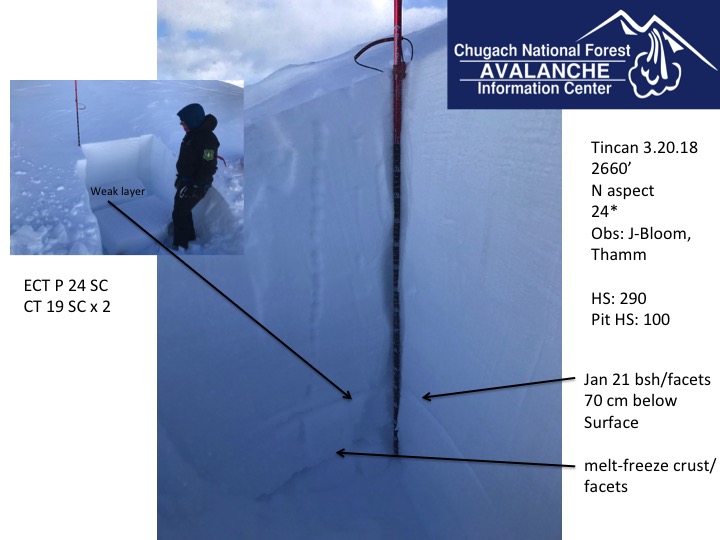
A large avalanche was remotely triggered by a helicopter landing at a pick-up spot in Winner Creek near Girdwood yesterday. This avalanche occured at 2500′ and released on the layer of weak faceted snow on a slick crust that has been the culprit in most of the avalanches over the past week. It was triggered from 1/4 of a mile away, wrapped 750′ around a ridge releasing on multiple aspects and the crown was 3-6′ deep. The pick-up spot had been used 10 times the day before. Why did it go the 11th time? The likelihood of natural avalanches has decreased as winds have hammered many areas and stripped away all the soft snow but a skier or snowmachiner triggering an deep slab avalanche remains a very real and scary possibility. Knowing where in the terrain that avalanche could be triggered and what it will take to trigger it is the hard part. This is the unfortunate reality of this type of avalanche problem. With a deep slab problem it is important to remember no signs of instability may be present before a slope releases. It may be the 10th person onto the slope that finds the trigger point and slopes may be triggered remotely. It is crucial to visualize the consequences if the slope does slide. Are there terrain traps below? Bigger slope = Bigger avalanche. Thin spots near rocks and along ridgelines are likely areas to find the trigger point. Widespread buried surface hoar and facets have been well documented at all elevations under a thick, connected slab and finding the wrong spot could be deadly.
Crown in Winner Creek, avalanche wrapped around the ridge to the north.
Arrows point to crowns on both sides of the ridge
Snowpack structure on Tincan. Weak snow under a hard slab
Signal Word | Size (D scale) | Simple Descriptor |
Small | 1 | Unlikely to bury a person |
Large | 2 | Can bury a person |
Very Large | 3 | Can destroy a house |
Historic | 4 & 5 | Can destroy part or all of a village |
The Northwest winds continued for a second day yesterday blowing 25-35 mph and gusting into the 60s on Seattle Ridge. Winds are forecast to remain elevated today into tonight and then mellow out by tomorrow. Most of the soft snow is now either blown into the atmosphere or been pounded into hard slabs and sastrugi. However, while traveling along ridgelines, be aware of the potential for wind slabs on a variety of aspects due to unusual wind loading patterns and cross loading. Smooth supportable surfaces where the snow is hollow sounding are suspect, especially if the slope is unsupported. Look for cracking and identify terrain features with a pillow-shaped look where triggering a wind slab could break above you. A wind slab could step down to older snow in the snowpack and create a much deeper and more dangerous avalanche.
Seattle Ridge has been getting top-loaded by this wind direction.
Cornices are large and looming and wind loading can add stress. Give these an extra wide berth and limit exposure underneath them. A cornice fall could trigger an avalanche on a slope below.
Yesterday was partly cloudy with temperatures in the teens at upper elevations and low 30Fs at sea level. Winds continued from the NW building mid day blowing 20-35 mph and gusting into the 60s. Overnight skies were clear, temperatures were in the teens to mid 20s and winds remained strong.
Today is forecast to be sunny and clear with temperatures in the teens again at upper elevations and 20Fs to low 30Fs at lower elevations. Winds will be from the NW 15-30 mph gusting into the 40s and 50s. Temperatures overnight will be in the teens and single digits and winds are forecast to die down by the next morning.
Thursday and Friday look to be clear, sunny and calm. The next weather system moves in over the weekend and the pattern looks active into mid-week. Stay tuned for details.
Temp Avg (F) | Snow (in) | Water (in) | Snow Depth (in) | |
Center Ridge (1880′) | 24 | 0 | 0 | 82 |
Summit Lake (1400′) | 27 | 0 | 0 | 32 |
Alyeska Mid (1700′) | 24 | 0 | 0 | 77 |
Temp Avg (F) | Wind Dir | Wind Avg (mph) | Wind Gust (mph) | |
Sunburst (3812′) | 15 | NW | 13 | 41 |
Seattle Ridge (2400′) | 22 | NW | 35 | 67 |
Date | Region | Location | Observer |
---|---|---|---|
05/22/23 | Turnagain | Avalanche: Tincan | Nick D'Alessio |
05/12/23 | Turnagain | Avalanche: Tincan, Sunburst, Magnum, Cornbiscuit | Heather Thamm |
05/07/23 | Turnagain | Observation: Tincan – Bear Tracks | CNFAIC Staff |
05/05/23 | Turnagain | Observation: Seattle Ridge | AS/ WW Forecaster |
05/02/23 | Turnagain | Observation: Cornbiscuit | Schauer/ Sturgess Forecaster |
05/02/23 | Turnagain | Observation: Seward Hwy Turnagain Pass | Joel Curtis |
04/30/23 | Turnagain | Observation: Magnum | Ayla, Kit Crosby, Barton |
04/29/23 | Turnagain | Observation: Tincan | John Sykes |
04/28/23 | Turnagain | Avalanche: Taylor Pass/Pastoral | Schauer/ Creighton Forecaster |
04/28/23 | Turnagain | Avalanche: Tincan | Andy Moderow |
Status of riding areas across the Chugach NF is managed by the Glacier and Seward Ranger Districts, not avalanche center staff. Riding area information is posted as a public service to our users and updated based on snow depth and snow density to prevent resource damage at trailhead locations. Riding area questions contact: mailroom_r10_chugach@fs.fed.us
Area | Status | Weather & Riding Conditions |
---|---|---|
Glacier District |
Subscribe to Turnagain Pass
Avalanche Forecast by Email
This is a general backcountry avalanche advisory issued for Turnagain Arm with Turnagain Pass as the core advisory area. This advisory does not apply to highways, railroads or operating ski areas.