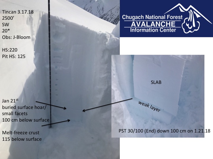
Turnagain Pass RSS

Archives
ARCHIVED - Forecasts expire after 24 hours.
Issued
Sun, March 18th, 2018 - 7:00AM
Expires
Mon, March 19th, 2018 - 7:00AM
Forecaster
Aleph Johnston-Bloom
Avalanche risk The Bottom Line

The avalanche danger is MODERATE above 1000′  on all aspects and CONSIDERABLE on all aspects below 1000′. Triggering a large, dangerous slab avalanche 2-4+’ thick is possible on all aspects above 1000′ and likely below 1000′ due to three days above freezing in that elevation band. Pay attention to daily warming and changing snow conditions. Remote triggering is possible. Evaluate terrain consequences and practice safe travel protocol.  

Dangerous avalanche conditions also exist in Summit Lake, check out the most recent  Summit snowpack and avalanche summary  if you are headed South of Turnagain Pass.


Special Announcements

CNFAIC has issued a  Special Avalanche Bulletin  for the weekend due to the potential for a skier or rider or snowmachiner triggering a dangerous slab avalanche. Lots of activity has occured this week region-wide from Lost Lake all the way to Girdwood and even a few reports of natural avalanches in  South Fork, Eagle River.    Check out recent observations from Hatcher Pass HERE  and get the forecast at hpavalanche.org.

Roof avalanches continue to be a concern today with warm temperatures and rain, particularly around Girdwood where there is still snow on some roof tops. Be mindful of where children and pets are playing, vehicles parked and entrances to buildings in relation to loaded roofs.  

Sun, March 18th, 2018
Alpine
Above 2,500'
2 - Moderate
Avalanche risk
Treeline
1,000'-2,500'
2 - Moderate
Avalanche risk
Below Treeline
Below 1,000'
3 - Considerable
Avalanche risk
0 - No Rating
1 - Low
2 - Moderate
3 - Considerable
4 - High
5 - Extreme
Avalanche risk Avalanche risk Avalanche risk Avalanche risk Avalanche risk
Travel Advice Generally safe avalanche conditions. Watch for unstable snow on isolated terrain features. Heightened avalanche conditions on specific terrain features. Evaluate snow and terrain carefully; identify features of concern. Dangerous avalanche conditions. Careful snowpack evaluation, cautious route-finding, and conservative decision-making essential. Very dangerous avalanche conditions. Travel in avalanche terrain not recommended. Extraordinarily dangerous avalanche conditions. Avoid all avalanche terrain.
Likelihood of Avalanches Natural and human-triggered avalanches unlikely. Natural avalanches unlikely; human-triggered avalanches possible. Natural avalanches possible; human-triggered avalanches likely. Natural avalanches likely; human-triggered avalanches very likely. Natural and human-triggered avalanches certain.
Avalanche Size and Distribution Small avalanches in isolated areas or extreme terrain. Small avalanches in specific areas; or large avalanches in isolated areas. Small avalanches in many areas; or large avalanches in specific areas; or very large avalanches in isolated areas. Large avalanches in many areas; or very large avalanches in specific areas. Very large avalanches in many areas.
Avalanche Problem 1
  • Deep Persistent Slabs
    Deep Persistent Slabs
  • Certain
    Very Likely
    Likely
    Possible
    Unlikely
    Likelihood
  • Historic (D4-5)
    Very Large (D3)
    Large (D2)
    Small (D1)
    Size
Deep Persistent Slabs
Deep Persistent Slab avalanches are the release of a thick cohesive layer of hard snow (a slab), when the bond breaks between the slab and an underlying persistent weak layer deep in the snowpack. The most common persistent weak layers involved in deep, persistent slabs are depth hoar or facets surrounding a deeply buried crust. Deep Persistent Slabs are typically hard to trigger, are very destructive and dangerous due to the large mass of snow involved, and can persist for months once developed. They are often triggered from areas where the snow is shallow and weak, and are particularly difficult to forecast for and manage.

Likelihood of Avalanches
Terms such as "unlikely", "likely", and "certain" are used to define the scale, with the chance of triggering or observing avalanches increasing as we move up the scale. For our purposes, "Unlikely" means that few avalanches could be triggered in avalanche terrain and natural avalanches are not expected. "Certain" means that humans will be able to trigger avalanches on many slopes, and natural avalanches are expected.

Size of Avalanches
Avalanche size is defined by the largest potential avalanche, or expected range of sizes related to the problem in question. Assigned size is a qualitative estimate based on the destructive classification system and requires specialists to estimate the harm avalanches may cause to hypothetical objects located in the avalanche track (AAA 2016, CAA 2014). Under this schema, "Small" avalanches are not large enough to bury humans and are relatively harmless unless they carry people over cliffs or through trees or rocks. Moving up the scale, avalanches become "Large" enough to bury, injure, or kill people. "Very Large" avalanches may bury or destroy vehicles or houses, and "Historic" avalanches are massive events capable of altering the landscape.

Signal Word Size (D scale) Simple Descriptor
Small 1 Unlikely to bury a person
Large 2 Can bury a person
Very Large 3 Can destroy a house
Historic 4 & 5 Can destroy part or all of a village
More info at Avalanche.org

Triggering a large destructive avalanche 2-4+ feet thick is the concern today. Yesterday there was no natural activity observed but there were two remote triggered avalanches reported. Notably a snowmachiner triggered a slope in Main Bowl that had tracks on it from the day before. Without much sun or a dramatic temperature rise in the forecast today triggering an avalanche maybe more stubborn to trigger but no less dangerous. “Scary Moderate” or “Spicy Moderate” are good ways to describe the conditions today, with the exception of terrain below 1000′ where triggering will be likely due to no freeze for the last 3 days. Keep that in mind in choosing terrain in Placer and Portage. With a deep slab problem it is important to remember no signs of instability may be present before a slope releases, it may be the 1st or the 10th person onto the slope that finds the trigger point and slopes maybe triggered remotely. It is crucial to visualize the consequences if the slope does slide. Are there terrain traps below?  Bigger slope = Bigger avalanche. Thin spots near rocks and along ridgelines are likely areas to find the trigger point. 

Large human triggered avalanches and/or natural avalanches have released daily over the past week from Seward all the way to Girdwood. Some of these avalanches have been remotely triggered while others have released after a skier or snowmachiner were well onto a slope. So far we’ve seen one ‘very large’ natural avalanche, where the crown was a mile-wide, on a NE aspect of Skookum Valley near Placer.  Most of these avalanches have occurred below 3000’, releasing on weak faceted snow on a slick crust, 2-4 feet below the surface. A lot of uncertainty remains in the Alpine where slab depths are much deeper and triggering an avalanche could be more stubborn. Widespread buried surface hoar and facets have been well documented at all elevations. Unfortunately choosing to travel in avalanche terrain with slabs this deep and persistent weak layers is like playing Russian Roulette.  You could get away with it… or have a very bad day…

Main Bowl avalanche yesterday on an East aspect. This was a remote snowmachine trigger from the flatter gentle area below avalanche. No one was caught. Photos: Brian Bird

Snowpit from Tincan yesterday. Check out the slab depth and visualize triggering an avalanche that deep….

 Avalanche activity from the past week

Avalanche Problem 2
  • Wet Loose
    Wet Loose
  • Certain
    Very Likely
    Likely
    Possible
    Unlikely
    Likelihood
  • Historic (D4-5)
    Very Large (D3)
    Large (D2)
    Small (D1)
    Size
Wet Loose
Wet Loose avalanches are the release of wet unconsolidated snow or slush. These avalanches typically occur within layers of wet snow near the surface of the snowpack, but they may quickly gouge into lower snowpack layers. Like Loose Dry Avalanches, they start at a point and entrain snow as they move downhill, forming a fan-shaped avalanche. Other names for loose-wet avalanches include point-release avalanches or sluffs. Loose Wet avalanches can trigger slab avalanches that break into deeper snow layers.

Likelihood of Avalanches
Terms such as "unlikely", "likely", and "certain" are used to define the scale, with the chance of triggering or observing avalanches increasing as we move up the scale. For our purposes, "Unlikely" means that few avalanches could be triggered in avalanche terrain and natural avalanches are not expected. "Certain" means that humans will be able to trigger avalanches on many slopes, and natural avalanches are expected.

Size of Avalanches
Avalanche size is defined by the largest potential avalanche, or expected range of sizes related to the problem in question. Assigned size is a qualitative estimate based on the destructive classification system and requires specialists to estimate the harm avalanches may cause to hypothetical objects located in the avalanche track (AAA 2016, CAA 2014). Under this schema, "Small" avalanches are not large enough to bury humans and are relatively harmless unless they carry people over cliffs or through trees or rocks. Moving up the scale, avalanches become "Large" enough to bury, injure, or kill people. "Very Large" avalanches may bury or destroy vehicles or houses, and "Historic" avalanches are massive events capable of altering the landscape.

Signal Word Size (D scale) Simple Descriptor
Small 1 Unlikely to bury a person
Large 2 Can bury a person
Very Large 3 Can destroy a house
Historic 4 & 5 Can destroy part or all of a village
More info at Avalanche.org

Wet loose avalanches or roller balls today are indicative of solar radiation and/ or daily warming temperatures affecting change on the snowpack. We have been seeing this throughout the week with unusually warm temperatures. It has been above freezing for 72 hours below 1000′. A wet point release could be small to large and has the potential to trigger a much larger, more dangerous slab, particularly on steep southerly aspects. If the sun comes out this afternoon or if rain showers are more intense than forecast, be on the lookout for natural wet loose activity. Pay attention to the surface conditions and sinking in to soft wet snow. 

Additional Concern
  • Cornice
    Cornice
Cornice
Cornice Fall is the release of an overhanging mass of snow that forms as the wind moves snow over a sharp terrain feature, such as a ridge, and deposits snow on the downwind (leeward) side. Cornices range in size from small wind drifts of soft snow to large overhangs of hard snow that are 30 feet (10 meters) or taller. They can break off the terrain suddenly and pull back onto the ridge top and catch people by surprise even on the flat ground above the slope. Even small cornices can have enough mass to be destructive and deadly. Cornice Fall can entrain loose surface snow or trigger slab avalanches.
More info at Avalanche.org

Cornices have grown significantly since the March 9th storm, an event that arrived with strong winds and dumped 3-4’ of new snow. Give corniced ridges an extra wide berth and minimize time spent below them. A cornice fall could trigger and propagate an avalanche on a slope below.


Weather
Sun, March 18th, 2018

Yesterday was partly sunny with a band of valley fog in the morning and became overcast in the afternoon. Temperatures were in the 20Fs to low 30Fs at upper elevations and the 30Fs to low 40Fs at lower elevations. Winds were light and easterly. Overnight skies were cloudy and temperatures dropped slightly.  

Today will be mostly cloudy with a chance of some brief periods of clearing in the afternoon. There is a chance of snow showers today and a chance of rain showers late in the day below 500′. Winds are forecast to remain light. Temperatures will be in the 30Fs at lower elevations and 20Fs at upper elevations. 1-5″   of snow is expected overnight and with rain possible below 500′.  

Monday snow showers continue into the morning and then as a ridge of high pressure and cooler air sets up expect clearing in the afternoon. Sunshine, cooler temperatures and possibly strong winds are on tap for the beginning of the week. The pattern looks to shift back to stormy and warmer for the next weekend. Stay tuned!  

PRECIPITATION 24-hour data (6am – 6am)

  Temp Avg (F) Snow (in) Water (in) Snow Depth (in)
Center Ridge (1880′) 33    0  0  84
Summit Lake (1400′)  32      0  0  31
Alyeska Mid (1700′)  35      0  0  77

RIDGETOP 24-hour data (6am – 6am)

  Temp Avg (F) Wind Dir Wind Avg (mph) Wind Gust (mph)
Sunburst (3812′)  24 E    3  11
Seattle Ridge (2400′)  27  E      5  14
Observations
Recent Observations for Turnagain Pass
Date Region Location
04/23/24 Turnagain Observation: Turnagain Sunny Side
04/21/24 Turnagain Observation: Bertha Creek
04/20/24 Turnagain Avalanche: Spokane Creek
04/16/24 Turnagain Observation: Cornbiscuit
04/15/24 Turnagain Observation: Taylor Pass
04/15/24 Turnagain Observation: Seward Highway – Tern Lake to Portage
04/14/24 Turnagain Observation: Sunburst
04/14/24 Turnagain Observation: Turnagain Pass Snomo
04/13/24 Turnagain Observation: Spokane Creek
04/11/24 Turnagain Observation: Tincan
Riding Areas

The riding areas page has moved. Please click here & update your bookmarks.


Subscribe to Turnagain Pass
Avalanche Forecast by Email

This is a general backcountry avalanche advisory issued for Turnagain Arm with Turnagain Pass as the core advisory area. This advisory does not apply to highways, railroads or operating ski areas.