Turnagain Pass RSS

Archives
ARCHIVED - Forecasts expire after 24 hours.
Issued
Sun, February 25th, 2018 - 7:00AM
Expires
Mon, February 26th, 2018 - 7:00AM
Forecaster
Wendy Wagner
Avalanche risk The Bottom Line

The avalanche danger is CONSIDERABLE on slopes above treeline that have seen recent wind loading. Human triggered wind slab avalanches 10-20″ thick are likely to be triggered and natural avalanches are possible. A MODERATE danger exists below treeline where triggering a wind slab in exposed areas is possible. Sluffs, composed of Friday’s snow, are likely on steep sustained slopes above 1,000′.   Additionally, old weak layers deeper in the pack may be triggered by a person or wind slab that steps down, creating a larger avalanche.

Special Announcements

The final Near Miss Report from the avalanche on Twin Peaks that occured Saturday, February 3rd is available  HERE. Thanks to all involved for sharing their description of events and lessons learned.  

Sun, February 25th, 2018
Alpine
Above 2,500'
3 - Considerable
Avalanche risk
Treeline
1,000'-2,500'
2 - Moderate
Avalanche risk
Below Treeline
Below 1,000'
1 - Low
Avalanche risk
0 - No Rating
1 - Low
2 - Moderate
3 - Considerable
4 - High
5 - Extreme
Avalanche risk Avalanche risk Avalanche risk Avalanche risk Avalanche risk
Travel Advice Generally safe avalanche conditions. Watch for unstable snow on isolated terrain features. Heightened avalanche conditions on specific terrain features. Evaluate snow and terrain carefully; identify features of concern. Dangerous avalanche conditions. Careful snowpack evaluation, cautious route-finding, and conservative decision-making essential. Very dangerous avalanche conditions. Travel in avalanche terrain not recommended. Extraordinarily dangerous avalanche conditions. Avoid all avalanche terrain.
Likelihood of Avalanches Natural and human-triggered avalanches unlikely. Natural avalanches unlikely; human-triggered avalanches possible. Natural avalanches possible; human-triggered avalanches likely. Natural avalanches likely; human-triggered avalanches very likely. Natural and human-triggered avalanches certain.
Avalanche Size and Distribution Small avalanches in isolated areas or extreme terrain. Small avalanches in specific areas; or large avalanches in isolated areas. Small avalanches in many areas; or large avalanches in specific areas; or very large avalanches in isolated areas. Large avalanches in many areas; or very large avalanches in specific areas. Very large avalanches in many areas.
Avalanche Problem 1
  • Wind Slabs
    Wind Slabs
  • Certain
    Very Likely
    Likely
    Possible
    Unlikely
    Likelihood
  • Historic (D4-5)
    Very Large (D3)
    Large (D2)
    Small (D1)
    Size
Wind Slabs
Wind Slab avalanches are the release of a cohesive layer of snow (a slab) formed by the wind. Wind typically transports snow from the upwind sides of terrain features and deposits snow on the downwind side. Wind slabs are often smooth and rounded and sometimes sound hollow, and can range from soft to hard. Wind slabs that form over a persistent weak layer (surface hoar, depth hoar, or near-surface facets) may be termed Persistent Slabs or may develop into Persistent Slabs.

Likelihood of Avalanches
Terms such as "unlikely", "likely", and "certain" are used to define the scale, with the chance of triggering or observing avalanches increasing as we move up the scale. For our purposes, "Unlikely" means that few avalanches could be triggered in avalanche terrain and natural avalanches are not expected. "Certain" means that humans will be able to trigger avalanches on many slopes, and natural avalanches are expected.

Size of Avalanches
Avalanche size is defined by the largest potential avalanche, or expected range of sizes related to the problem in question. Assigned size is a qualitative estimate based on the destructive classification system and requires specialists to estimate the harm avalanches may cause to hypothetical objects located in the avalanche track (AAA 2016, CAA 2014). Under this schema, "Small" avalanches are not large enough to bury humans and are relatively harmless unless they carry people over cliffs or through trees or rocks. Moving up the scale, avalanches become "Large" enough to bury, injure, or kill people. "Very Large" avalanches may bury or destroy vehicles or houses, and "Historic" avalanches are massive events capable of altering the landscape.

Signal Word Size (D scale) Simple Descriptor
Small 1 Unlikely to bury a person
Large 2 Can bury a person
Very Large 3 Can destroy a house
Historic 4 & 5 Can destroy part or all of a village
More info at Avalanche.org

Triggering a fresh wind slab avalanche will be our main concern. Ridgetop winds from the Northwest picked up yesterday and have strengthened overnight. Several wind slabs (mostly small, some large) were reported in the Turnagain Pass area along with one large natural seen in the Skookum Valley. These were around 1 foot thick and running far – due to entrainment of 4-8+” of loose snow sitting on hard old surfaces. The increase in wind overnight will only increase the size and likelihood of triggering these slabs. Although winds are forecast to decrease today, they could persist through the daylight hours. Unusual loading patterns have been seen with this wind direction and therefore all aspects are suspect. Wind slabs should be mostly found in the Alpine above the trees, but could also be found in open areas in the trees. 

What to watch for:
–  Recent avalanches – take a look around today, visibility should be good
–  Shooting cracks from your snowmachine/skis/board
–  Areas that are currently being wind loaded or that ‘look’ as they have been recently – round and pillowed surfaces
–  Watch out from above – a party yesterday was washed over by a natural wind slab/sluff to their waist.

*Wind slabs are a surface instability that can typically be easily identified if we watch for them. Unlike the deeper weak layers mentioned below.

Sluffs: Sluffing in Friday’s storm snow (4-8+”) will be likely on steep slopes again today. 

Solar effects:  If the winds die down enough on South facing slopes, the sun will have a good chance at warming the surface creating moist sluffs and possibly triggering a fresh wind slab. In this case, avoid steep solar aspects if you notice roller balls or point releases under rocks. 

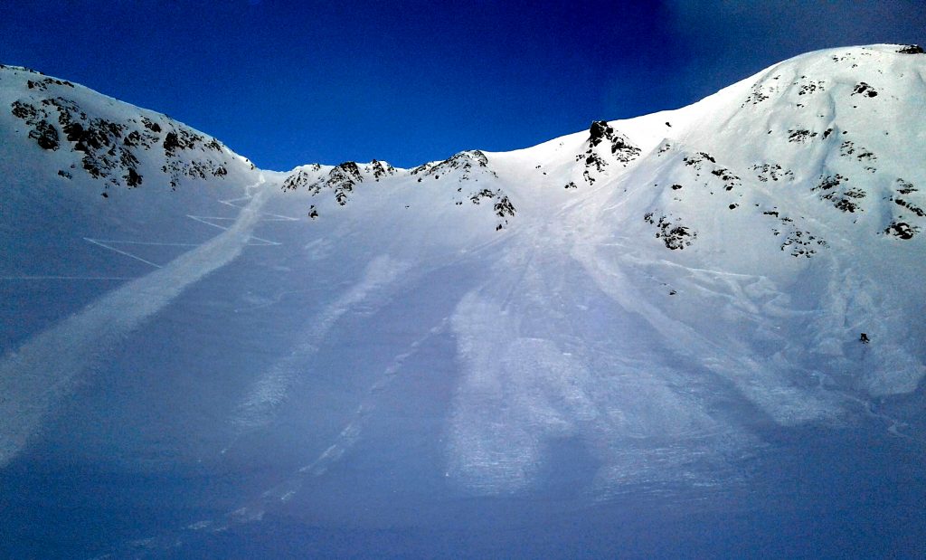
Natural and skier triggered sluffs and wind slabs seen in the Magnum/Cornbiscuit (Subperbowl and Goldpan) area yesterday. (Photo: Mike Records)


Sluff on the North side of Magnum – seen from Sunburst ridge. (Photo: Allen Dahl)


Cracking in the new snow – sign of finding a wind slab. (Photo: Allen Dahl)


Avalanche Problem 2
  • Persistent Slabs
    Persistent Slabs
  • Certain
    Very Likely
    Likely
    Possible
    Unlikely
    Likelihood
  • Historic (D4-5)
    Very Large (D3)
    Large (D2)
    Small (D1)
    Size
Persistent Slabs
Persistent Slab avalanches are the release of a cohesive layer of snow (a slab) in the middle to upper snowpack, when the bond to an underlying persistent weak layer breaks. Persistent layers include: surface hoar, depth hoar, near-surface facets, or faceted snow. Persistent weak layers can continue to produce avalanches for days, weeks or even months, making them especially dangerous and tricky. As additional snow and wind events build a thicker slab on top of the persistent weak layer, this avalanche problem may develop into a Deep Persistent Slab.

Likelihood of Avalanches
Terms such as "unlikely", "likely", and "certain" are used to define the scale, with the chance of triggering or observing avalanches increasing as we move up the scale. For our purposes, "Unlikely" means that few avalanches could be triggered in avalanche terrain and natural avalanches are not expected. "Certain" means that humans will be able to trigger avalanches on many slopes, and natural avalanches are expected.

Size of Avalanches
Avalanche size is defined by the largest potential avalanche, or expected range of sizes related to the problem in question. Assigned size is a qualitative estimate based on the destructive classification system and requires specialists to estimate the harm avalanches may cause to hypothetical objects located in the avalanche track (AAA 2016, CAA 2014). Under this schema, "Small" avalanches are not large enough to bury humans and are relatively harmless unless they carry people over cliffs or through trees or rocks. Moving up the scale, avalanches become "Large" enough to bury, injure, or kill people. "Very Large" avalanches may bury or destroy vehicles or houses, and "Historic" avalanches are massive events capable of altering the landscape.

Signal Word Size (D scale) Simple Descriptor
Small 1 Unlikely to bury a person
Large 2 Can bury a person
Very Large 3 Can destroy a house
Historic 4 & 5 Can destroy part or all of a village
More info at Avalanche.org

Triggering a slab avalanche breaking in persistent weak layers 1-3 feet deep remains possible above 1000’. Additionally, a wind slab or sluff has the potential to step down and trigger one of these layers. A layer of buried surface hoar from Jan. 21st continues to show signs of reactivity in the upper elevations, and a layer of facets over a melt-freeze crust is suspect in the mid elevation band. Be suspect of the older snow under Friday’s storm snow. Red flags like shooting cracks or “whumpfing” may not be present before a slope releases. Evaluate the terrain for consequences and be aware of places that haven’t seen much traffic. These less traveled places are more suspect for triggering these deeper layers.

Deep Persistent Slabs: Keep in mind that there are deeper persistent layers that could ‘wake up’ if the wrong spot is found above 3,000′. At these high elevations, old weak layers of facets and buried surface hoar sit in the bottom half of the snowpack. This structure is most pronounced in places with a thin overall snow cover, such as the South end of Turnagain Pass, the Summit Lake area and Crow Pass. 

Weather
Sun, February 25th, 2018

Mostly cloudy skies gave way to partly sunny skies late in the day yesterday. A trace to an inch of snow was recorded as Friday’s storm moved out in the morning. Ridgetop winds were moderate with strong gusts from the Northwest and have increased overnight. The Seattle Ridge station has been averaging 20-35mph with gusts to 60mph overnight. The Sunburst station on the other hand, is somewhat protected from this wind direction and reporting lower than observed winds (averages 10mph from the NW). Temperatures were in the teens at the upper elevations and 20’sF in valley bottoms.

For today, we can expect the ridgetop winds to remain moderate to strong from the Northwest, with averages between 10-20+mph and gusts to 50mph. Skies should be mostly sunny until later tonight when clouds move in along with snowfall. Overnight, we could see 2-3″ of new snow. Temperatures will be in the 5-15F range along the ridgelines and 15-25F in valley bottoms.  

For Monday, the next system should be impacting the area. The Southwesterly flow associated with this storm will favor snowfall in the Hatcher Pass and Front Range zones more than Turnagain Pass where only 4-6″ of new snow is expected. See graphic from the NWS below. Strong Northwest winds are expected late Monday and into Tuesday as the system exits. Temperatures will remain cold enough for snow to sea level. Stay tuned!


PRECIPITATION 24-hour data (6am – 6am)

  Temp Avg (F) Snow (in) Water (in) Snow Depth (in)
Center Ridge (1880′) 27   0   0   68  
Summit Lake (1400′) 19   1   0.1   30  
Alyeska Mid (1700′) 19   1   0.05   60  

RIDGETOP 24-hour data (6am – 6am)

  Temp Avg (F) Wind Dir Wind Avg (mph) Wind Gust (mph)
Sunburst (3812′) 11   NW   10   40  
Seattle Ridge (2400′) 18   NW   26   59  
Observations
Recent Observations for Turnagain Pass
Date Region Location
03/28/24 Turnagain Observation: Sunburst
03/27/24 Turnagain Observation: Tincan Trees
03/26/24 Turnagain Observation: Cornbiscuit
03/25/24 Turnagain Observation: Tincan
03/22/24 Turnagain Avalanche: Magnum Northwest Aspect
03/21/24 Turnagain Observation: Sunburst
03/21/24 Turnagain Observation: Tincan Proper North Aspect
03/20/24 Turnagain Avalanche: Seattle Creek Drainage
03/19/24 Turnagain Observation: Tincan CFR
03/18/24 Turnagain Avalanche: Tincan – Eddies – Seattle Ridge
Riding Areas

The riding areas page has moved. Please click here & update your bookmarks.


Subscribe to Turnagain Pass
Avalanche Forecast by Email

This is a general backcountry avalanche advisory issued for Turnagain Arm with Turnagain Pass as the core advisory area. This advisory does not apply to highways, railroads or operating ski areas.