Turnagain Pass Avalanche Forecast
|
![]() ![]() |
The avalanche danger is MODERATE above 1,000′ on all aspects. Triggering an isolated wind slab or a more connected persistent slab 1-2′ deep is possible today. Look for moist snow or small point releases on solar aspect where the sun could make slabs more reactive. Additionally, weak layers deeper in the snowpack may still be triggered, creating a larger avalanche.
Dangerous avalanche conditions are anticipated in Hatcher Pass today following a foot of new snow that fell yesterday. Human triggered slab avalanches are likely today. If you see any activity please send in an observation to Hatcher Pass Avalanche Center HERE.
Signal Word | Size (D scale) | Simple Descriptor |
Small | 1 | Unlikely to bury a person |
Large | 2 | Can bury a person |
Very Large | 3 | Can destroy a house |
Historic | 4 & 5 | Can destroy part or all of a village |
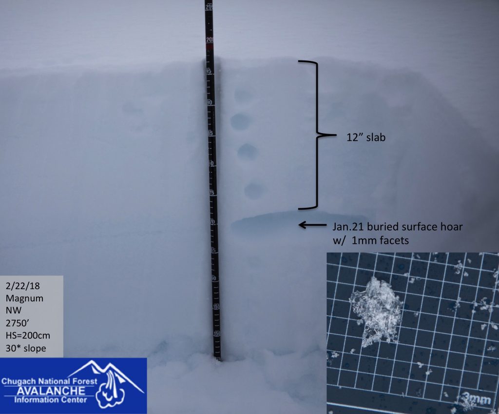
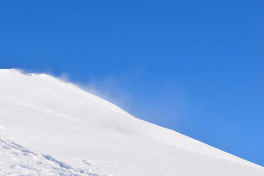
Triggering a slab avalanche 1-2+ feet deep remains possible above 1000’ due several weak layers buried within the snowpack. A layer of buried surface hoar from Jan. 21st continues to show signs of reactivity in the upper elevations, and a layer of facets over a melt-freeze crust is suspect in the mid elevation band. The slab ranges from hard to soft depending on exposure to recent winds. Speaking of wind… yesterday we had 3-4” inches of new snow combined a strong Northwest winds overnight. This wind direction can funnel through Turnagain Pass from a variety of directions causing unusual wind loading patterns. Be suspect of hard snow over soft snow that feels upside down or where the slab is fully supportable or hollow sounding. Red flags like shooting cracks or “whumpfing” may not be present before a slope releases. Evaluate the terrain for consequences and be aware of places that haven’t seen much traffic. These less traveled places are more suspect for triggering a more connected slab.
Deep Persistent Slabs: Keep in mind that there are deeper persistent layers that could ‘wake up’ if you find the wrong spot above 3,000′ in the Alpine. At these high elevations, old weak layers of facets and buried surface hoar sit in the bottom half of the snowpack. This structure is most pronounced in places with a thin overall snow cover, such as the South end of Turnagain Pass, the Summit Lake area and Crow Pass.
Left picture shows the buried surface hoar about a 1′ below the surface, and the right hand picture is an example of the weak faceted snow sitting on a slick crust in the mid elevations.
Signal Word | Size (D scale) | Simple Descriptor |
Small | 1 | Unlikely to bury a person |
Large | 2 | Can bury a person |
Very Large | 3 | Can destroy a house |
Historic | 4 & 5 | Can destroy part or all of a village |
Triggering a small isolated wind slab is possible today on steep unsupported terrain features where winds have been transporting snow. These slab will likely be hard and supportable due to strong winds overnight. A slab could release from above once committed to a steep slope. Identify smooth pillow-shaped snow and cross loaded gullies and be aware that buried weak layers are widespread throughout our region. It may be difficult to distinguish between a small isolated wind slab versus a more connected persistent slab.
Sunshine: It’s that time of year when we need to pay attention to the sun. The sun can heat up Southerly aspects, and melt surface snow and cause small point releases in the loose new snow. This will be more of a concern if winds are calm today, which may be the case this afternoon. This heating can also cause a slab sitting on a weak layer to become more reactive. Avoid steep solar aspect if you notice the surface snow becoming moist or you see roller balls or point releases under rocks.
Moderate North winds loading a Southern aspect on Tincan yesterday afternoon.
A storm yesterday brought 3-4 € of new snow throughout our region followed by a strong Northwest wind event. These winds started late afternoon and have continued through the morning. Gap areas like Turnagain Arm have experienced stronger winds. Seattle Ridge weather station was averaging in the 30’s mph overnight with gusts into the 60’s and 70’s. Sunburst weather station was more protected and the strongest winds were reported early this morning with gust into the 30’s mph. Ridgetop temperatures dropped from the 20F’s into the low teens (F) overnight. Sea level temps remained in the 20F’s overnight.
Today expect clear and sunny skies most of the day. High clouds are expected by this evening as another low pressure system move into our region overnight. Northwest winds are expected to decrease this morning remaining light from the Northwest this afternoon. Temperatures will be in the mid 20F’s in upper elevations and may rise to low 30’s at sea level. Snow showers may start by late evening.
Several inches of new snow are forecasted by Saturday. An active Southwest pattern will bring a period of clear skies on Sunday followed by another round of snow on Monday. Southwest flow tends to favor Cook Inlet and the Matanuska Valley for snow, but precipitation is expected across our region. Temperatures should remain near normal averaging in the 20’s to mid 30’s with daily warming. Precipitation is expected to remain as snow.
*Center Ridge weather station has been producing erratic temperature data.
PRECIPITATION 24-hour data (6am – 6am)
Temp Avg (F) | Snow (in) | Water (in) | Snow Depth (in) | |
Center Ridge (1880′) | *33 | 3 | .2 | 65 |
Summit Lake (1400′) | 25 | 2 | .2 | 25 |
Alyeska Mid (1700′) | 25 | 2 | .2 | 57 |
Temp Avg (F) | Wind Dir | Wind Avg (mph) | Wind Gust (mph) | |
Sunburst (3812′) | 18 | NW | 10 | 34 |
Seattle Ridge (2400′) | 24 | NW | 23 | 73 |
Date | Region | Location | Observer |
---|---|---|---|
01/31/23 | Turnagain | Observation: Johnson Pass area | Megan Guinn / W Wagner Forecaster |
01/29/23 | Turnagain | Observation: Tincan Backdoor | AAS-Level 1 1/27-1/30 |
01/28/23 | Turnagain | Observation: Sunburst | Brooke Edwards |
01/28/23 | Turnagain | Avalanche: Seattle Ridge | W Wagner |
01/28/23 | Turnagain | Observation: Tincan Common | Tony Naciuk |
01/27/23 | Turnagain | Observation: Sunburst | John Sykes |
01/27/23 | Turnagain | Avalanche: Lynx Creek | Megan Guinn / W Wagner |
01/25/23 | Turnagain | Observation: Cornbiscuit | John Sykes Forecaster |
01/22/23 | Turnagain | Avalanche: Tincan | Schauer/ Guinn |
01/21/23 | Turnagain | Avalanche: Seattle Ridge | Elias Holt |
Status of riding areas across the Chugach NF is managed by the Glacier and Seward Ranger Districts, not avalanche center staff. Riding area information is posted as a public service to our users and updated based on snow depth and snow density to prevent resource damage at trailhead locations. Riding area questions contact: mailroom_r10_chugach@fs.fed.us
Area | Status | Weather & Riding Conditions |
---|---|---|
Glacier District |
Subscribe to Turnagain Pass
Avalanche Forecast by Email
This is a general backcountry avalanche advisory issued for Turnagain Arm with Turnagain Pass as the core advisory area. This advisory does not apply to highways, railroads or operating ski areas.