Turnagain Pass RSS

Archives
ARCHIVED - Forecasts expire after 24 hours.
Issued
Thu, March 30th, 2017 - 7:00AM
Expires
Fri, March 31st, 2017 - 7:00AM
Forecaster
Wendy Wagner
Avalanche risk The Bottom Line

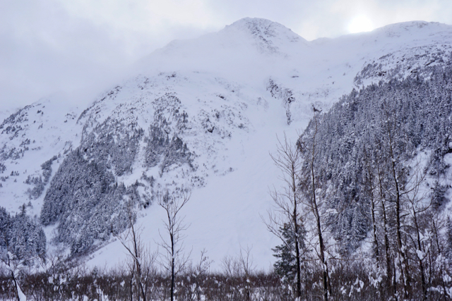
There remains a HIGH avalanche danger in the Alpine (above 2,500′). Natural wind slab avalanches 2-4′ thick will be likely due to strong winds forecast today in the mountains surrounding the Eastern Turnagain Arm (such as Turnagain Pass, Girdwood Valley and Placer Valley). Below 2,500′ and in areas out of the wind, a CONSIDERABLE avalanche danger exists for storm slabs 1-2′ thick composed of new snow from Tuesday night’s storm. Natural cornice falls are also possible and could trigger slabs below along with loose snow avalanches. With the continued active weather pattern, today will be another day to avoid avalanche terrain.

*A potent storm system moving in tonight is expected to keep the danger elevated into the weekend.  

Hiking in Portage Valley:  Travel along, and past, the designated Byron Glacier trail is not recommended due to exposure to avalanche terrain. Natural avalanches are possible today that could send debris to valley floors.

Summit Lake:   Roughly 6-8″ of new snow fell as of yesterday. Strong winds are expected in this region as well. Read the  Saturday Summit Summary  HERE.

Special Announcements

Tomorrow is the deadline for applying for your 2017 PFD!! Please consider showing your support for public avalanche centers when applying – the Friends of the Chugach National Forest Avalanche Center is an  official  Pick. Click. Give. organization!

*A reminder that the Skookum Valley closes to motorized use on April 1st, this Saturday.  All other motorized areas remain open – see area status on the bottom of this page for more information.

Thu, March 30th, 2017
Alpine
Above 2,500'
4 - High
Avalanche risk
Treeline
1,000'-2,500'
3 - Considerable
Avalanche risk
Below Treeline
Below 1,000'
3 - Considerable
Avalanche risk
0 - No Rating
1 - Low
2 - Moderate
3 - Considerable
4 - High
5 - Extreme
Avalanche risk Avalanche risk Avalanche risk Avalanche risk Avalanche risk
Travel Advice Generally safe avalanche conditions. Watch for unstable snow on isolated terrain features. Heightened avalanche conditions on specific terrain features. Evaluate snow and terrain carefully; identify features of concern. Dangerous avalanche conditions. Careful snowpack evaluation, cautious route-finding, and conservative decision-making essential. Very dangerous avalanche conditions. Travel in avalanche terrain not recommended. Extraordinarily dangerous avalanche conditions. Avoid all avalanche terrain.
Likelihood of Avalanches Natural and human-triggered avalanches unlikely. Natural avalanches unlikely; human-triggered avalanches possible. Natural avalanches possible; human-triggered avalanches likely. Natural avalanches likely; human-triggered avalanches very likely. Natural and human-triggered avalanches certain.
Avalanche Size and Distribution Small avalanches in isolated areas or extreme terrain. Small avalanches in specific areas; or large avalanches in isolated areas. Small avalanches in many areas; or large avalanches in specific areas; or very large avalanches in isolated areas. Large avalanches in many areas; or very large avalanches in specific areas. Very large avalanches in many areas.
Avalanche Problem 1
  • Storm Slabs
    Storm Slabs
Storm Slabs
Storm Slab avalanches are the release of a cohesive layer (a slab) of new snow that breaks within new snow or on the old snow surface. Storm-slabs typically last between a few hours and few days (following snowfall). Storm-slabs that form over a persistent weak layer (surface hoar, depth hoar, or near-surface facets) may be termed Persistent Slabs or may develop into Persistent Slabs.
More info at Avalanche.org

After a brief break between storms, another system is literally on the doorstep. This one is characteristic of a Classic Chugach Storm – warm, wet and windy. Opposed to Tuesday night’s storm which was cool and calm; meaning 1-2+ feet of new snow fell with relatively light winds. Avalanche activity yesterday consisted of many natural and remotely triggered storm slab avalanches in the Girdwood Valley and Placer Valley where over 2 feet of snow fell. Observers noted significant propagation with these slabs which points to the fact the new snow is sitting on weak old snow. In general, visibility was very hampered and at Turnagain Pass where only a foot of new snow fell, only one natural avalanche was seen on Tincan’s Southerly face under Hippie Bowl

As of 5am this morning winds from the East are just ramping up – expected to average in the 25-40mph range. Snow is expected to begin later today with 2-6″ forecast by 6pm and another 6-12″ forecast tonight. The strong winds will be the main contributing factor to avalanche activity today, yet there are other avalanches issues present. The whole run down is:

WIND SLABS and CORNICES:
Strong winds today should have an easy time moving yesterday’s new snow around and loading leeward slopes, creating large wind slabs and cornices. These are likely to release naturally and could entrain enough snow to run quite far. In areas such as Portage Valley where over 2′ of new snow has already fallen, these slabs could run to sea level.

STORM SLAB AVALANCHES:
In areas out of the wind, expect the recent storm snow to still be touchy. Where up to 2 feet of new snow has already fallen, such as Girdwood Valley and Placer Valley, human triggered slab avalanches 1-2′ thick are still likely, as was the case yesterday. At Turnagain Pass, with only a foot of new, shallow slabs and sluffs are possible.

LOOSE SNOW AVALANCHES:
Sluffs in the new snow should be expected on all aspects and elevations – this issue is overshadowed however by the much more concerning avalanche problems mentioned above.

All this said, with the active weather over the region, travel is avalanche terrain is not recommended. Sticking to the flats, well away from runout zones, heading to the local ski hill or filing your PFD/doing taxes are all good options for the next few days!

Five Sisters slide path in the Portage Valley. Skies opened just enough to see several crowns 2-3′ thick in the recent storm snow; hard to see in the photo. Fresh debris did not run to the valley floor, only part way down over the older debris.


14″ of new snow sits over facets on North aspects (photo below) and a sun crust (.5 – 1″ thick) on Southerly asepcts at Turnagain Pass on Tincan.


Satellite image from 6:00 am (infrared image) of the large low-pressure headed our way today and forecast to churn warm, wet and windy weather in the region through the weekend.


Avalanche Problem 2
  • Persistent Slabs
    Persistent Slabs
Persistent Slabs
Persistent Slab avalanches are the release of a cohesive layer of snow (a slab) in the middle to upper snowpack, when the bond to an underlying persistent weak layer breaks. Persistent layers include: surface hoar, depth hoar, near-surface facets, or faceted snow. Persistent weak layers can continue to produce avalanches for days, weeks or even months, making them especially dangerous and tricky. As additional snow and wind events build a thicker slab on top of the persistent weak layer, this avalanche problem may develop into a Deep Persistent Slab.
More info at Avalanche.org

Don’t forget that our snowpack harbors several old layers of weak snow. Avalanches releasing in the storm snow have the potential to ‘step down’ into these layers. Furthermore, as the new snow piles up and begins to stick to the old snow surface, avalanches breaking into them is possible as well. Both of these situations can create a much larger avalanche – something to look for in the coming days.

Weather
Thu, March 30th, 2017

Intense snowfall from Tuesday night’s storm tapered off significantly by noon yesterday. Storm total was 12-14″ of new moist snow on Turnagain Pass and 24-34″ in the Girdwood Valley and Placer Valley. Skies were mostly cloudy and temperatures were warm – upper 30’sF at sea level and the mid 20’sF along the ridgelines. Ridgetop winds during the past 24-hours have been light (5-10mph) from the East – but have just bumped to moderate (15mph) as of 5am this morning.

Today, ridgetop winds will continue to increase with averages up into the 25-40mph range from an Easterly direction with gusts into the 50’s+ mph. This is in advance of a large low-pressure system moving in bringing warm, wet and windy weather. Precipitation should begin later this morning with 2-6″ of snow to sea level accumulating by 6pm and another 6-12″ by 6am tomorrow. Temperatures should climb today into the low 30’s F at sea level and stay in the mid 20’sF along the ridgelines.

Tomorrow, Friday, warm air is expected to push in bringing the rain/snow line to between 500 and 1,000′. Another foot(ish) of snow is expected on Friday above 1,000′. Stay tuned as this Chugach Storm develops!

PRECIPITATION 24-hour data (6am – 6am)

  Temp Avg (F) Snow (in) Water (in) Snow Depth (in)
Center Ridge (1880′) 32   1   0.1   69  
Summit Lake (1400′) 25   1   0.1   34
Alyeska Mid (1700′) 27   5   0.35   75  

RIDGETOP 24-hour data (6am – 6am)

  Temp Avg (F) Wind Dir Wind Avg (mph) Wind Gust (mph)
Sunburst (3812′) 20   NE   5   27  
Seattle Ridge (2400′) 24   N   5   40  
Observations
Recent Observations for Turnagain Pass
Date Region Location
04/23/24 Turnagain Observation: Turnagain Sunny Side
04/21/24 Turnagain Observation: Bertha Creek
04/20/24 Turnagain Avalanche: Spokane Creek
04/16/24 Turnagain Observation: Cornbiscuit
04/15/24 Turnagain Observation: Taylor Pass
04/15/24 Turnagain Observation: Seward Highway – Tern Lake to Portage
04/14/24 Turnagain Observation: Sunburst
04/14/24 Turnagain Observation: Turnagain Pass Snomo
04/13/24 Turnagain Observation: Spokane Creek
04/11/24 Turnagain Observation: Tincan
Riding Areas

The riding areas page has moved. Please click here & update your bookmarks.


Subscribe to Turnagain Pass
Avalanche Forecast by Email

This is a general backcountry avalanche advisory issued for Turnagain Arm with Turnagain Pass as the core advisory area. This advisory does not apply to highways, railroads or operating ski areas.