Turnagain Pass Avalanche Forecast
|
![]() ![]() |
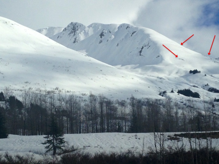
A CONSIDERABLE avalanche danger remains on all slopes under 2,500′ in elevation due to an active glide avalanche cycle. Destructive glide avalanches are occurring daily across the region. Avoid being under the runout of glide cracks. In addition to glide avalanches, natural wet loose avalanches are possible and human triggered likely in steep terrain that harbors wet and saturated snow.
In the Alpine the avalanche danger is generally LOW. Watching for lingering wind slabs, cornice falls and human triggered wet loose avalanches.
***Travel is not recommended in avalanche terrain on the West (motorized side of Turnagain Pass).
AVALANCHE OUTLOOK for Monday, April 18th:
Monday looks to be very similar to today. In general all the avalanche instabilities that have been mostly confined to the 1000′-2500′ elevation band may slowly creep into the Alpine as the temperatures remain warm and the sun shines during the day. Pay attention to changing conditions. The hazard may increase to MODERATE in the Alpine.
Yesterday at least one new glide avalanche was observed. What was most notable was that new cracks continue to appear and grow. The West facing terrain on Cornbiscuit now is littered with small, progressing cracks that make it essentially un-skinnable. Magnum West face and South face both have growing cracks and even Sunburst’s “mini” glide crack is getting more pronounced. This all indicates snow on the move. Pick your route carefully in the 1000′-2500′ elevation band.
This current wet snowpack, combined with mostly sunny skies and temperatures above freezing, has us continuing to think glide activity is likely. Our message remains the same: AVOID being under glide cracks and respective runout zones. To be in the wrong place at the wrong time when a glide releases could likely be deadly. Considering the motorized up-track is threatened by cracks, we are recommending that people do not travel on the up-track or in runout areas along Seattle Ridge.
Cornbiscuit glide cracks. 4/16
Wet loose avalanches have been occurring for the past few days. These have been naturally occurring with warm temperatures, rain and direct sunlight affecting surface snow and mostly confined to the 1000′-2500′ elevation band. Expect more of the same today and potentially an increase with clearing skies. The few inches of new snow that fell over the past few days above 2000′ is primed if heated enough and lower elevation snow is completely saturated. Human triggering a wet loose avalanche in steep terrain is likely. Pay attention to ski penetration and punchy snow as well as roller balls both natural and travel initiated. Remember wet loose avalanches can be hard to escape once initiated and particularly hazardous if they push you into a terrain trap. Take into account what terrain is above you and what you may have to cross under to get back to your car when venturing to cooler snow in the Alpine.
Wet loose activity on Seattle Ridge with glide cracks and old glide avalanches.
At elevations above 2,500′ and in the Alpine the snowpack is generally stable. There are a few things to watch for if traveling in the upper elevations:
– Lingering wind slabs that could be triggered in steep, unsupported terrain.
– Cornice falls (we have yet to see cornices start falling in the Alpine but this could happen any day with the warm temperatures and direct sunlight).
– Wet loose avalanches on steep solar aspects, both natural and human triggered. These have been predominantly confined to the 1000′-2500′ elevation band but this may change and be higher with heating throughout the next two days.
Yesterday was mostly cloudy in the morning with isolated rain and snow showers trending to partly cloudy by mid afternoon. Temperatures were in the upper 20Fs to upper 30Fs. Winds were light and easterly.
Today and tomorrow are forecasted to be mostly to partly sunny with temperatures in the high 30Fs at 3000′ and the high 40Fs at 1000′. Winds will be light and variable. Scattered showers will be a possibility Monday afternoon with increasing clouds and precipitation on tap for Tuesday.
Temp Avg (F) | Snow (in) | Water (in) | Snow Depth (in) | |
Center Ridge (1880′) | 36 | 0 | 0 | 110 |
Summit Lake (1400′) | 37 | 0 | 0 | 27 |
Alyeska Mid (1700′) | 35 | 0 | .1 | 95 |
Temp Avg (F) | Wind Dir | Wind Avg (mph) | Wind Gust (mph) | |
Sunburst (3812′) | 30 | ENE | 10 | 20 |
Seattle Ridge (2400′) | 29 | SE | 15 | 28 |
Date | Region | Location | Observer |
---|---|---|---|
01/31/23 | Turnagain | Observation: Johnson Pass area | Megan Guinn / W Wagner Forecaster |
01/29/23 | Turnagain | Observation: Tincan Backdoor | AAS-Level 1 1/27-1/30 |
01/28/23 | Turnagain | Observation: Sunburst | Brooke Edwards |
01/28/23 | Turnagain | Avalanche: Seattle Ridge | W Wagner |
01/28/23 | Turnagain | Observation: Tincan Common | Tony Naciuk |
01/27/23 | Turnagain | Observation: Sunburst | John Sykes |
01/27/23 | Turnagain | Avalanche: Lynx Creek | Megan Guinn / W Wagner |
01/25/23 | Turnagain | Observation: Cornbiscuit | John Sykes Forecaster |
01/22/23 | Turnagain | Avalanche: Tincan | Schauer/ Guinn |
01/21/23 | Turnagain | Avalanche: Seattle Ridge | Elias Holt |
Status of riding areas across the Chugach NF is managed by the Glacier and Seward Ranger Districts, not avalanche center staff. Riding area information is posted as a public service to our users and updated based on snow depth and snow density to prevent resource damage at trailhead locations. Riding area questions contact: mailroom_r10_chugach@fs.fed.us
Area | Status | Weather & Riding Conditions |
---|---|---|
Glacier District |
Subscribe to Turnagain Pass
Avalanche Forecast by Email
This is a general backcountry avalanche advisory issued for Turnagain Arm with Turnagain Pass as the core advisory area. This advisory does not apply to highways, railroads or operating ski areas.