Turnagain Pass RSS

Archives
ARCHIVED - Forecasts expire after 24 hours.
Issued
Tue, March 8th, 2016 - 7:00AM
Expires
Wed, March 9th, 2016 - 7:00AM
Forecaster
Graham Predeger
Avalanche risk The Bottom Line

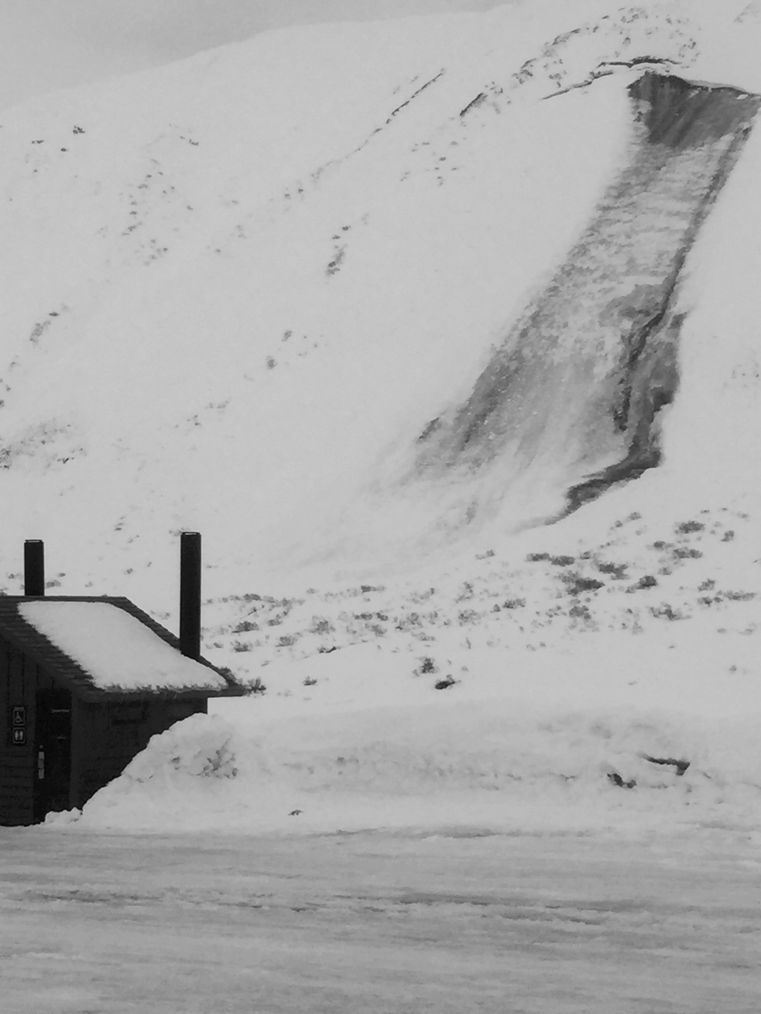
The avalanche hazard is MODERATE today above 1,000′.   Glide cracks continue to pose a very real and serious threat to a substantial amount of terrain frequented by skiers and snowmachiners in the mid-elevations.   Above treeline, surface instabilities such as shallow wind slabs and loose snow sluffing make up the secondary concern today.

Cornices deserve mention as well as they loom precariously over a lot of well-travelled terrain and have been releasing as recently as yesterday.

Special Announcements

Interested in how people make decisions in avalanche terrain?  Montana State University’s Snow and Avalanche Laboratory, is leading a project they hope will bring about a better understanding of those risk-taking decisions with a smartphone app.    Click here for more info, to participate and submit YOUR Alaska data to this international research project.  Snowmachiners,  click here.

Tue, March 8th, 2016
Alpine
Above 2,500'
2 - Moderate
Avalanche risk
Treeline
1,000'-2,500'
2 - Moderate
Avalanche risk
Below Treeline
Below 1,000'
0 - No Rating
Avalanche risk
0 - No Rating
1 - Low
2 - Moderate
3 - Considerable
4 - High
5 - Extreme
Avalanche risk Avalanche risk Avalanche risk Avalanche risk Avalanche risk
Travel Advice Generally safe avalanche conditions. Watch for unstable snow on isolated terrain features. Heightened avalanche conditions on specific terrain features. Evaluate snow and terrain carefully; identify features of concern. Dangerous avalanche conditions. Careful snowpack evaluation, cautious route-finding, and conservative decision-making essential. Very dangerous avalanche conditions. Travel in avalanche terrain not recommended. Extraordinarily dangerous avalanche conditions. Avoid all avalanche terrain.
Likelihood of Avalanches Natural and human-triggered avalanches unlikely. Natural avalanches unlikely; human-triggered avalanches possible. Natural avalanches possible; human-triggered avalanches likely. Natural avalanches likely; human-triggered avalanches very likely. Natural and human-triggered avalanches certain.
Avalanche Size and Distribution Small avalanches in isolated areas or extreme terrain. Small avalanches in specific areas; or large avalanches in isolated areas. Small avalanches in many areas; or large avalanches in specific areas; or very large avalanches in isolated areas. Large avalanches in many areas; or very large avalanches in specific areas. Very large avalanches in many areas.
Avalanche Problem 1
  • Glide Avalanches
    Glide Avalanches
Glide Avalanches
Glide Avalanches are the release of the entire snow cover as a result of gliding over the ground. Glide avalanches can be composed of wet, moist, or almost entirely dry snow. They typically occur in very specific paths, where the slope is steep enough and the ground surface is relatively smooth. They are often proceeded by full depth cracks (glide cracks), though the time between the appearance of a crack and an avalanche can vary between seconds and months. Glide avalanches are unlikely to be triggered by a person, are nearly impossible to forecast, and thus pose a hazard that is extremely difficult to manage.
More info at Avalanche.org

We’ve seen 2 new glide cracks ‘pop’ in the last 24 hours, and several others in the past week.  Though incredibly unpredictable as to when these cracks may avalanche, we have noticed that some cracks are growing in size and are showing their ugly faces once again, allowing us to map them out and plan travel accordingly.  It’s an easy avalanche problem to mitigate; simply avoiding time spent exposed under these yawning cracks.  Though the probability of tangling with a glide in motion is low, the consequences will be fatal if you are in the wrong spot at that moment when stress overcomes strength and a glide crack turns into a glide avalanche.

If you’re a daily reader of this advisory you’ll notice this is the 61st day in a row where we’ve made mention of glide avalanches, unfortunately there is no end in sight.  It’s been an unusual season in this respect and as the old-timers say; unusual conditions breed unusual avalanches.

An unmistakable example of the avalanche problem we are dealing with reared it’s head yesterday morning, just outside of the motorized parking lot (East face of Seattle ridge).  The crown on this full-depth glide avalanche is easily 10 feet deep.


Oblique view of the same glide as above, looking south toward Johnson Pass and Lynx creek.

Avalanche Problem 2
  • Wind Slabs
    Wind Slabs
Wind Slabs
Wind Slab avalanches are the release of a cohesive layer of snow (a slab) formed by the wind. Wind typically transports snow from the upwind sides of terrain features and deposits snow on the downwind side. Wind slabs are often smooth and rounded and sometimes sound hollow, and can range from soft to hard. Wind slabs that form over a persistent weak layer (surface hoar, depth hoar, or near-surface facets) may be termed Persistent Slabs or may develop into Persistent Slabs.
More info at Avalanche.org

Shallow wind slabs (6-10”) were proving reactive to skiers on Sunday after a bump in Easterly winds Saturday.  With another slight bump yesterday (gusting to the mid-30’s mph on Sunburst), we could continue to see some shallow wind slab activity in the upper elevations.  Key in to any cracking, wind-textured or stiffer surfaces to suss out a wind slab.  No consequence test slopes will be a valuable tool today to get a better idea of reactivity and average depth of wind slab we’re dealing with.

Loose snow:

Loose snow sluffing will warrant management today if skiing the steeps.  Sluffs have been reported to be fast moving with the ability to entrain a significant amount of surface snow in big terrain.  This will be more pronounced on cooler, shadier North aspects.

Additional Concern
  • Cornice
    Cornice
Cornice
Cornice Fall is the release of an overhanging mass of snow that forms as the wind moves snow over a sharp terrain feature, such as a ridge, and deposits snow on the downwind (leeward) side. Cornices range in size from small wind drifts of soft snow to large overhangs of hard snow that are 30 feet (10 meters) or taller. They can break off the terrain suddenly and pull back onto the ridge top and catch people by surprise even on the flat ground above the slope. Even small cornices can have enough mass to be destructive and deadly. Cornice Fall can entrain loose surface snow or trigger slab avalanches.
More info at Avalanche.org

Listen to your Mother’s voice in your head and “stay away from the edge.”  Take her advice and double it to give yourself a wider berth than you AND your Mother think necessary.  Furthermore, be very wary of spending time beneath cornices.  A group yesterday heard/ witnessed a large cornice failure off the S face of Kickstep during the heat of the day (2:30pm).  These are becoming larger and weaker, ebbing closer to the point of failure as we move in to Spring.

Weather
Tue, March 8th, 2016

Greybird was the word in Turnagain pass yesterday.   Skies were overcast with just a trace of moisture falling.   Temperatures averaged 32F at 1,000′ and winds were in the low teens gusting to the mid-30’s from the East on ridge tops.  

Today looks to be almost a carbon-copy day of yesterday.   High clouds are streaming in from a well-developed Low centered in the Gulf of Alaska.   Temps will be in the mid-30’s at 1,000′, ridgetop winds are expected to be in the teens or less from the East and precipitation will be nominal through Turnagain Pass.  

Tomorrow we may have a weak ridge move over the eastern Turnagain arm area promoting partly sunny skies before the our next chance of active weather on Thursday.

PRECIPITATION 24-hour data (6am – 6am)

  Temp Avg (F) Snow (in) Water (in) Snow Depth (in)
Center Ridge (1880′)  32  1 .1   136  
Summit Lake (1400′) 34   0   0   43  
Alyeska Mid (1700′)  32  0 .05   106  

RIDGETOP 24-hour data (6am – 6am)

  Temp Avg (F) Wind Dir Wind Avg (mph) Wind Gust (mph)
Sunburst (3812′) 24    NE 10  34
Seattle Ridge (2400′) 26   n/a   n/a   n/a  
Observations
Recent Observations for Turnagain Pass
Date Region Location
03/27/24 Turnagain Observation: Tincan Trees
03/26/24 Turnagain Observation: Cornbiscuit
03/25/24 Turnagain Observation: Tincan
03/22/24 Turnagain Avalanche: Magnum Northwest Aspect
03/21/24 Turnagain Observation: Sunburst
03/21/24 Turnagain Observation: Tincan Proper North Aspect
03/20/24 Turnagain Avalanche: Seattle Creek Drainage
03/19/24 Turnagain Observation: Tincan CFR
03/18/24 Turnagain Avalanche: Tincan – Eddies – Seattle Ridge
03/18/24 Turnagain Observation: Tincan
Riding Areas

The riding areas page has moved. Please click here & update your bookmarks.


Subscribe to Turnagain Pass
Avalanche Forecast by Email

This is a general backcountry avalanche advisory issued for Turnagain Arm with Turnagain Pass as the core advisory area. This advisory does not apply to highways, railroads or operating ski areas.