Turnagain Pass Avalanche Forecast
|
![]() ![]() |
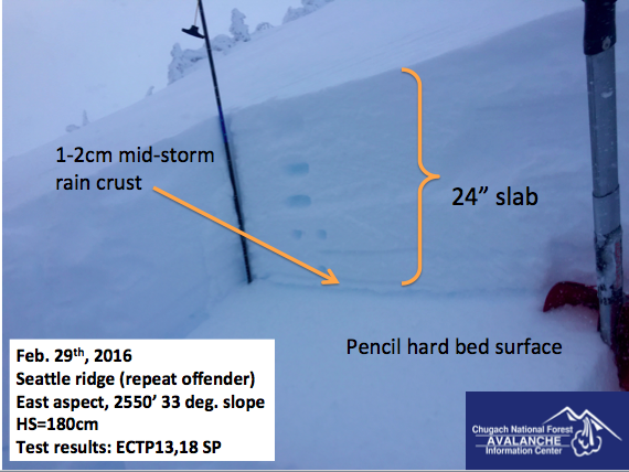
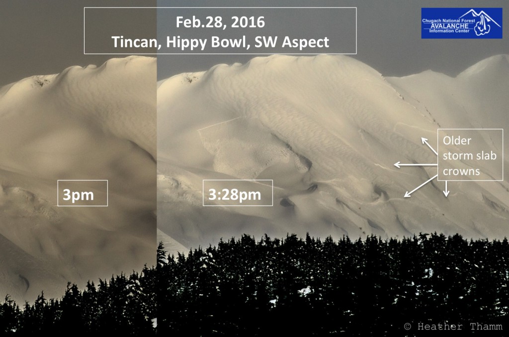
Avalanche Danger in the Alpine and treeline elevations (above 1,000′) is CONSIDERABLE today given a multitude of different avalanche problems currently present. As this 9-day storm begins to wrap up today we have very little data from the alpine. What data we do have, points toward a snowpack with some potential mid-storm weaknesses that needs time to adapt to an enormous load of snow and water weight (11 €+ water over 9 days). Very cautious route finding and conservative decision-making will be essential today if venturing into the mountains. The sun is expected to make an appearance today and its worth noting that direct sun and warming temperatures will compound these avalanche problems listed below.
The danger is MODERATE below 1,000′ where debris from an avalanche above could run in steep terrain.
Elevated caution and a conservative mindset is recommended in the Summit Lake area where a variety of avalanche concerns also exist. See Saturday’s Summit Lake Summary and click HERE for recent observations.
With just a few short breaks in weather over the last 9 days, we appear to be on the verge of a pattern change as it looks like we’ll be under at least a couple of days of high pressure starting this afternoon. Storm snow issues listed below are of concern today and may prove more reactive if we get a spike in ambient temperatures, or a period of unobstructed sunshine.
Storm slabs: Yesterday we found reactive storm slabs at 2500’ in our snow pit that consistently failed and propagated about 2 feet below the surface. Granted, this is only one data point, but it happens to be on arguably the most heavily traveled piece of terrain in the Turnagain zone (Seattle ridge uptrack). This may have been the same weak layer responsible for a Sunday afternoon natural storm slab on Tincan. More data will help us understand if this weakness is widespread, but for today, keeping slope angles mellow and picking very conservative travel routes will be key.
Pit results yesterday identified a concerning mid-storm crust at 2500′ on Seattle ridge that proved reactive. See video here.
Wind slabs: There is ample snow available in the alpine for transport. Winds have been primarily from the E and NE over the last several days loading any slope with a westerly tilt. Last night, winds kicked back up into the 40’s, gusting to 70mph on Sunburst. As with their cornice brethren, wind slabs have the potential to be large and dangerous today. Avoid steep, wind loaded slopes and recognize that any direct sun today could act to weaken these wind slabs.
Cornices: These continue to grow large and unruly with the addition of more wind and snow. Give cornices a wide berth if travelling on or below a corniced ridge. Any significant cornice fall today is likely to trigger an avalanche on the slope below.
The wild card…. Glide cracks have continued to release during this storm cycle, still with no real discernable pattern. Many cracks continue to litter the slopes above well-travelled terrain on both the motorized and non-motorized side of the highway. Simply avoid exposure time spent below existing cracks to minimize your risk. The photo below is a good reminder that if a skier or snowmachiner were to tangle with one of these full-depth glide avalanches, odds of survival are slim to none.
Snowmachine for scale next to the toe of a glide avalanche. This released Thursday night/ Friday morning on the East face of Seattle ridge depositing 15-20′ of debris on a well-traveled snowmachine route.
Temperatures at 1,000′ were slightly cooler yesterday (32F) than they have been for several days. This promoted a discernable rain/ snow line at about 500′ with a few short bursts of snow at sea level before turning to all rain. New snow accumulation added up to 4-6 € at 1,000′. Winds were in the teens and gusting to the 30’s mph at ridgetop locations as clouds funneled in and out of the Pass.
A pattern change is underway today as stormy weather gives way to clearing skies, calming winds and cooler temperatures overnight tonight. Today winds are expected to start out in the 15-30mph range from the East, dropping off to single digits by this afternoon. Temperatures at 1,000′ will be in the low to mid-30’s F before cooling off overnight and we may see 1-2 € of snow squeezed out this morning before skies break apart.
High pressure will dominate through Thursday before our next chance of snow arrives prior to the weekend.
A quick snapshot of SWE data at the Turnagain Pass SNOTEL thru February. Red is current water year. Green is the long-term average and blue is the year we’d all like to forget (last year).
Temp Avg (F) | Snow (in) | Water (in) | Snow Depth (in) | |
Center Ridge (1880′) | 30 | 4-6″ | .6 | 146 |
Summit Lake (1400′) | 32 | 0 | .1 | 41 |
Alyeska Mid (1700′) | 32 | 2 | .2 | 106 |
Temp Avg (F) | Wind Dir | Wind Avg (mph) | Wind Gust (mph) | |
Sunburst (3812′) | 21 | ENE | 26 | 70 |
Seattle Ridge (2400′) | 24 | n/a | n/a | n/a |
Date | Region | Location | Observer |
---|---|---|---|
05/22/23 | Turnagain | Avalanche: Tincan | Nick D'Alessio |
05/12/23 | Turnagain | Avalanche: Tincan, Sunburst, Magnum, Cornbiscuit | Heather Thamm |
05/07/23 | Turnagain | Observation: Tincan – Bear Tracks | CNFAIC Staff |
05/05/23 | Turnagain | Observation: Seattle Ridge | AS/ WW Forecaster |
05/02/23 | Turnagain | Observation: Cornbiscuit | Schauer/ Sturgess Forecaster |
05/02/23 | Turnagain | Observation: Seward Hwy Turnagain Pass | Joel Curtis |
04/30/23 | Turnagain | Observation: Magnum | Ayla, Kit Crosby, Barton |
04/29/23 | Turnagain | Observation: Tincan | John Sykes |
04/28/23 | Turnagain | Avalanche: Taylor Pass/Pastoral | Schauer/ Creighton Forecaster |
04/28/23 | Turnagain | Avalanche: Tincan | Andy Moderow |
Status of riding areas across the Chugach NF is managed by the Glacier and Seward Ranger Districts, not avalanche center staff. Riding area information is posted as a public service to our users and updated based on snow depth and snow density to prevent resource damage at trailhead locations. Riding area questions contact: mailroom_r10_chugach@fs.fed.us
Area | Status | Weather & Riding Conditions |
---|---|---|
Glacier District |
Subscribe to Turnagain Pass
Avalanche Forecast by Email
This is a general backcountry avalanche advisory issued for Turnagain Arm with Turnagain Pass as the core advisory area. This advisory does not apply to highways, railroads or operating ski areas.