None observed today but visibility was pretty poor all day.
Observation: Turnagain
Location: Seattle ridge- Repeat offender
Motorized parking lot to 2,000 (First bench on uptrack. Ditched sleds and skinned to Seattle ridge for a look in to Main Bowl (First bowl).
What cornices we did see appeared to be very large, like defying gravity large. One small wind feature skiers left at the top of main bowl has actually formed a full barrel!!
Observer Comments
Weather
Snowfall intensity was heavy at times. New snow accumulated to about 6" over the course of the day. 32F at 1,000'. 25F at 2500'. Winds were in the teens gusting to 30's on ridgetops actively transporting snow.
Snow surface
1,000 - 1,900': 6" new snow on a "soft" crust over very damp snow.
2,000 - 2,800': 3-12" soft (4F) wind slab over 1F supportable slab.
Snowpack
Snow surface dries out and you lose any semblance of the 'soft crust' at around 1,800 - 2,000'. Shallow wind slab (~1' deep) was felt from 2K to the ridge.
The one and only snowpit for the day yielded some interesting results (see video). Snowpit was at 2500', lookers left of the common uptrack to Seattle ridge. Total depth was 160 - 180cm (shallow spot). 2 different Extended column tests saw very similar results. ECTP13 and ECTP18 about 24" down, just below a thin rain crust. Fracture character was sudden planar on both tests. Rain crust was likely laid down mid-storm as it wasn't all that deep considering the amount of snow we've seen over the last 9 days.
Though only 1 single data point, this is a very concerning result and should warrant a very conservative mindset when traveling through the mountains until more information is gathered on our current snowpack/ structure in the wake of this late February storm.

Surface conditions at 2700', just before gaining Seattle ridge.
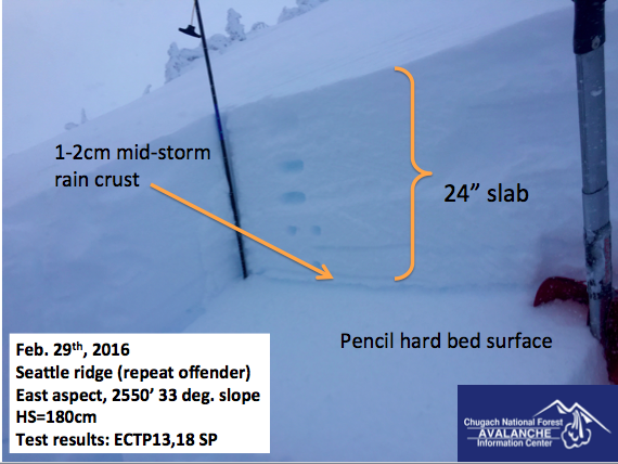
Snowpit at 2550' just lookers left of the Seattle ridge uptrack. ECT's both failed just below the thin rain crust, about 24" down. See video for test results.
This cornice still looms very large over zero bowl.

A humbling experience to be so close to glide avalanche debris. This glide released over night last Thursday night/ Friday morning and ran over a substantial snowmachine trail in the flats. See Wendy's observation on Saturday (2/27) for more photos.