Turnagain Pass Avalanche Forecast RSS

Archives
ARCHIVED FORECAST - All forecasts expire after 24 hours from the posting date/time.
Issued
Tue, January 12th, 2016 - 7:00AM
Expires
Wed, January 13th, 2016 - 7:00AM
Forecaster
Graham Predeger
Avalanche risk The Bottom Line

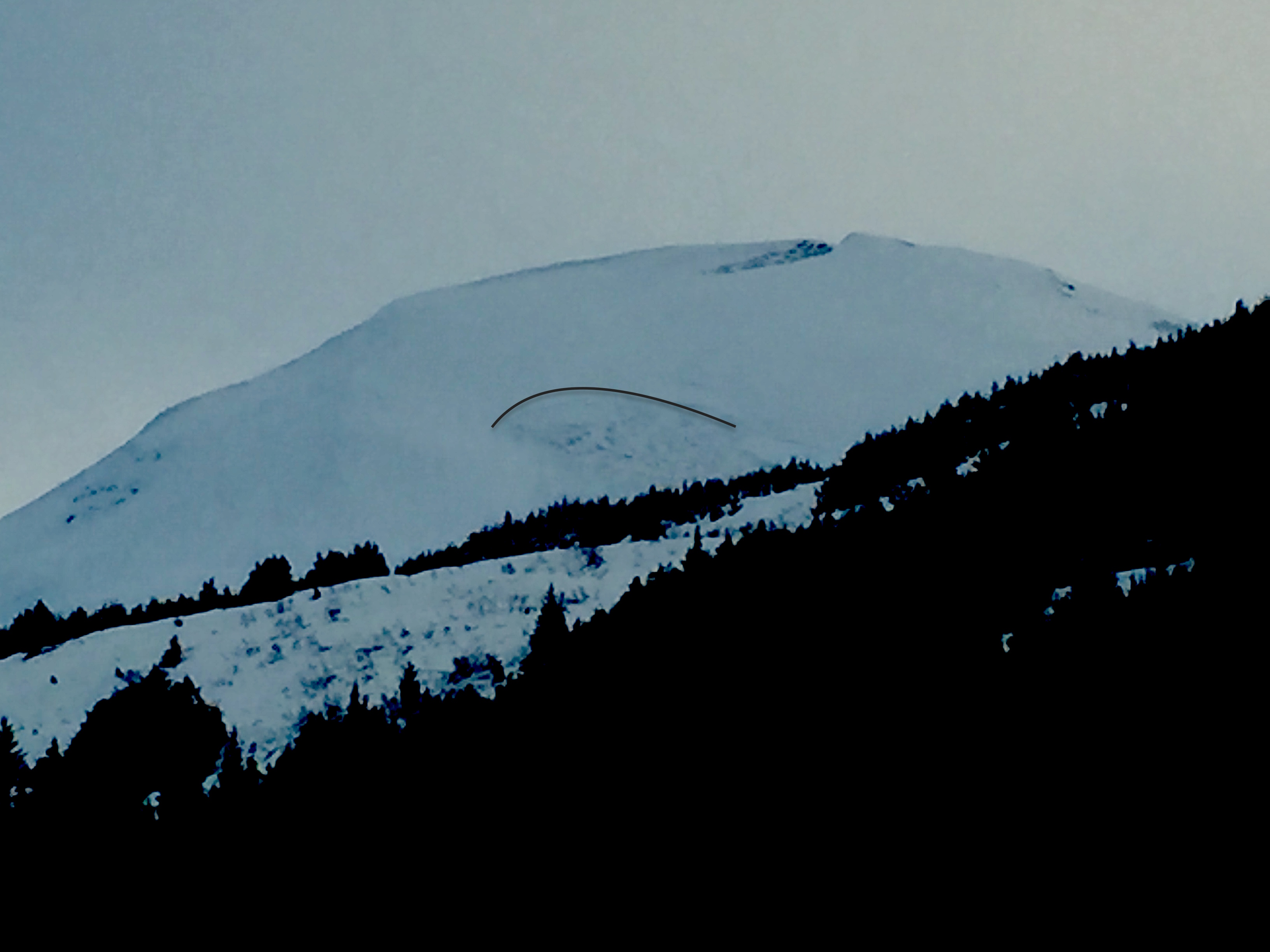
The avalanche danger is MODERATE today at and above treeline where cornices are looming large over wind-loaded terrain.   Triggering a wind slab 1-3′ in depth won’t be out of the question in steep, upper elevation terrain (greater than 35 degrees) either.   At treeline, the glide avalanche potential is real as the core advisory area is littered with glide cracks right now, some of which have avalanched to the ground over the last several days.

Below treeline the danger is LOW where an avalanche is unlikely after our snowpack has been bruised and beaten by rain, leaving it seasoned and well adjusted.    

In areas such as  Summit Lake,  the snowpack is shallower and harbors more weak layers. Click  HERE  to read Saturday’s Summit Lake Summary.  

Special Announcements

Filing for the PFD this week? Remember, The Friends of the CNFAIC is part of  PICK.CLICK.GIVE. Your donations are greatly appreciated and an integral part to making the CNFAIC possible and sustainable

Thanks to our sponsors!
Tue, January 12th, 2016
Alpine
Above 2,500'
Moderate (2)
Avalanche risk
Treeline
1,000'-2,500'
Moderate (2)
Avalanche risk
Below Treeline
Below 1,000'
Low (1)
Avalanche risk
Alpine
Above 2,500'
Avalanche risk
Moderate (2)
Treeline
1,000'-2,500'
Avalanche risk
Moderate (2)
Below Treeline
Below 1,000'
Avalanche risk
Low (1)
Danger Scale:
No Rating (0)
Low (1)
Moderate (2)
Considerable (3)
High (4)
Extreme (5)
Avalanche Problem 1
  • Glide Avalanches
    Glide Avalanches
Glide Avalanches
Glide Avalanches are the release of the entire snow cover as a result of gliding over the ground. Glide avalanches can be composed of wet, moist, or almost entirely dry snow. They typically occur in very specific paths, where the slope is steep enough and the ground surface is relatively smooth. They are often proceeded by full depth cracks (glide cracks), though the time between the appearance of a crack and an avalanche can vary between seconds and months. Glide avalanches are unlikely to be triggered by a person, are nearly impossible to forecast, and thus pose a hazard that is extremely difficult to manage.
More info at Avalanche.org

It’s not everyday that our avalanche problems are so obvious and visible to the naked eye but that seems to be the case today.  Found on all aspects, glide cracks seem to be relegated to the 1,000’ – 2,500’ elevation band.  Glide cracks are a strange beast that really are impossible to predict.  Weather and other triggers such as humans or even explosives that we associate with other dangerous avalanche problems don’t seem to effect glides in the same way.  There is no discernable pattern to predict a failure as they tend to fail naturally and on their own schedule.  Sometimes a glide crack won’t release at all, and benignly just fill back in with snow.  Knowing when or even whether a glide crack will avalanche is like asking is there “Life on Mars?”  Maybe, though the jury is still out so in the meantime, take your protein pill and put your helmet on!

Glide cracks are best to be given a wide berth.  Limit your exposure time spent underneath and if skiing in terrain with glide cracks, try and map them out before your decent so as not to end up directly on top of or inside one.  Remember, when these do fail, they tend to be destructive, failing to the ground bringing the entirety of the snowpack with them.

Large glide crack as seen ysterday from the highway, lookers left in Tincan trees. There are a lot of glide cracks in the Turnagain zone right now, but perhaps none as obvious as this one.


This glide released likely sometime over the weekend on the SW face of Lipps.  See more info and photos from Heather’s observation on 1/6.

Avalanche Problem 2
  • Cornice
    Cornice
Cornice
Cornice Fall is the release of an overhanging mass of snow that forms as the wind moves snow over a sharp terrain feature, such as a ridge, and deposits snow on the downwind (leeward) side. Cornices range in size from small wind drifts of soft snow to large overhangs of hard snow that are 30 feet (10 meters) or taller. They can break off the terrain suddenly and pull back onto the ridge top and catch people by surprise even on the flat ground above the slope. Even small cornices can have enough mass to be destructive and deadly. Cornice Fall can entrain loose surface snow or trigger slab avalanches.
More info at Avalanche.org

Cornices have grown considerably during the past few weeks. Not only do they have the potential to fall naturally, but also to be triggered by the weight of a person or snowmachine. They can also trigger an avalanche below and, all in all, be VERY dangerous. Travel under or on them should be avoided. And remember, they have the tendency to break farther back from the ridge than expected. 

Additional Concern
  • Wind Slabs
    Wind Slabs
Wind Slabs
Wind Slab avalanches are the release of a cohesive layer of snow (a slab) formed by the wind. Wind typically transports snow from the upwind sides of terrain features and deposits snow on the downwind side. Wind slabs are often smooth and rounded and sometimes sound hollow, and can range from soft to hard. Wind slabs that form over a persistent weak layer (surface hoar, depth hoar, or near-surface facets) may be termed Persistent Slabs or may develop into Persistent Slabs.
More info at Avalanche.org

We saw substantial winds over the weekend (30 – 70 mph from the east) and into yesterday that actively stripped windward slopes and built stiff windslabs in the alpine.  These may be in the 1-3’ range today and are most likely to be triggered from a rock outcrop or shallow spots near the edge of a slab.  Wind loaded slopes are visibly fat right now, pay attention to any red flags such as shooting cracks.  If you do decide to ski or snowmachine on a wind loaded slope greater than 35 degrees, do so one at a time and ensure you’ve got an escape route and a safe zone picked out.

Weather
Tue, January 12th, 2016

Yesterday was a balmy day across the advisory area.   Temperatures hovered around 36 degrees at 1,000′ under mostly cloudy skies.   Winds continued from the East yesterday in the 10-20mph range before dropping off substantially and switching direction (to NW) overnight.   A few light flurries were seen at ridgetops but no accumulation to note.  

Today our area will be influenced by a weak system moving east to west across southcentral AK.   Skies will be mostly obscured with clouds and a few scattered rain and snow showers persisting but not expected to add up to any accumulation.   Winds will be nearly non-existent (less than 10 mph) from the north with temperatures expected to be in the mid-30’s at 1,000′.

PRECIPITATION 24-hour data (6am – 6am)

  Temp Avg (F) Snow (in) Water (in) Snow Depth (in)
Center Ridge (1880′) 33   0   .1   87  
Summit Lake (1400′)  34 0   .1    27
Alyeska Mid (1700′)  33  0 .05   62  

RIDGETOP 24-hour data (6am – 6am)

  Temp Avg (F) Wind Dir Wind Avg (mph) Wind Gust (mph)
Sunburst (3812′)  26 ENE    6 33  
Seattle Ridge (2400′)  28 *N/A   *N/A   *N/A  

*A trip to Seattle ridge weather station yesterday found a broken anemometer due to heavy rime.  We’ll be working to get a replacement installed as soon as possible.

Observations
Recent Observations for Turnagain Pass
Date Region Location
05/22/23 Turnagain Avalanche: Tincan
05/12/23 Turnagain Avalanche: Tincan, Sunburst, Magnum, Cornbiscuit
05/07/23 Turnagain Observation: Tincan – Bear Tracks
05/05/23 Turnagain Observation: Seattle Ridge
05/02/23 Turnagain Observation: Cornbiscuit
05/02/23 Turnagain Observation: Seward Hwy Turnagain Pass
04/30/23 Turnagain Observation: Magnum
04/29/23 Turnagain Observation: Tincan
04/28/23 Turnagain Avalanche: Taylor Pass/Pastoral
04/28/23 Turnagain Avalanche: Tincan
Riding Areas
Updated Sat, September 23rd, 2023

Status of riding areas across the Chugach NF is managed by the Glacier and Seward Ranger Districts, not avalanche center staff. Riding area information is posted as a public service to our users and updated based on snow depth and snow density to prevent resource damage at trailhead locations. Riding area questions contact: mailroom_r10_chugach@fs.fed.us

Area Status Weather & Riding Conditions
Glacier District
Johnson Pass
Closed
Scheduled opening per Chugach National Forest plan December 1. Subject to adequate snow cover.
Placer River
Closed
Scheduled opening per Chugach National Forest plan December 1. Subject to adequate snow cover.
Skookum Drainage
Closed
Scheduled opening per Chugach National Forest plan December 1. Subject to adequate snow cover.
Turnagain Pass
Closed
Scheduled opening on the Wednesday before Thanksgiving per Chugach National Forest plan. Subject to adequate snow cover.
Twentymile
Closed
Scheduled opening per Chugach National Forest plan December 1. Subject to adequate snow cover.
Seward District
Carter Lake
Closed
Scheduled opening per Chugach National Forest plan December 1. Subject to adequate snow cover.
Lost Lake Trail
Closed
Scheduled opening per Chugach National Forest plan December 1. Subject to adequate snow cover.
Primrose Trail
Closed
Scheduled opening per Chugach National Forest plan December 1. Subject to adequate snow cover.
Resurrection Pass Trail
Closed
Scheduled opening per Chugach National Forest plan December 1. Subject to adequate snow cover.
Snug Harbor
Closed
Scheduled opening per Chugach National Forest plan December 1. Subject to adequate snow cover.
South Fork Snow River Corridor
Closed
Scheduled opening per Chugach National Forest plan December 1. Subject to adequate snow cover.
Summit Lake
Closed
Scheduled opening per Chugach National Forest plan December 1. Subject to adequate snow cover.

Subscribe to Turnagain Pass
Avalanche Forecast by Email

This is a general backcountry avalanche advisory issued for Turnagain Arm with Turnagain Pass as the core advisory area. This advisory does not apply to highways, railroads or operating ski areas.