Turnagain Pass Avalanche Forecast
|
![]() ![]() |
CONSIDERABLE avalanche danger exists in the Alpine where a human could easily trigger a slab 2-3′ thick in steep terrain. Below 2500′ MODERATE avalanche danger exists where triggering 20 € of low density snow in a terrain trap could have high consequences. Remember this new snow is sitting on a very weak pre-existing surface and not enough time has passed for the snowpack to adjust to its new load. Large numbers of people will be difficult to manage and warrants extra patience today. Change plans if crowds get too large and multiple people in avalanche terrain becomes a safety concern.
*Another large storm is moving into the area late this evening. If Easterly winds exceed the forecasted amount of 20-40mph today, expect avalanche danger to increase rapidly and adapt to changing conditions.
Large holiday crowds combined with a recent rapid loading event of 20” of new snow will make safe travel in the backcountry challenging. Today another 3-5” of snow and 20-40 mph ridgetop winds will be adding additional stress to the snowpack. Should crowds start pushing into steeper and more dangerous terrain human triggered avalanches in the alpine are likely.
Wind Slabs: Today’s Easterly winds will be forming new wind slabs on already wind loaded features. These slabs are sitting on a widespread weak layer and could easily produce slabs up to 3’ thick. Be on the look out for blowing snow, shooting cracks, and hollow sounding snow. Avoid steep wind loaded features where the snow is denser on the weaker snow below.
Storm Slabs: In places protected from the wind new snow could be tender and break easily on steep features. As this new snow settles and the slab become more cohesive the weak snow below is something to investigate. Hand pits will allow you to see how well the new snow is bonding to the weak snow below. Experiment on small, steep terrain features with low consequences, and avoid terrain traps.
Loose Snow Avalanches: This problem is a concern in areas with terrain traps, like at the bottom of a narrow gully or abrupt landing, where triggering loose snow could easily bury a person.
Today’s avalanche concerns combined with large holiday crowds are something to be very aware of. Remember not everyone reads this forecast and understands how to travel in avalanche terrain when hazards are elevated. Here are a few tips to keep in mind:
Large groups of people on Tincan yesterday made it difficult to know if other groups were above or below you.
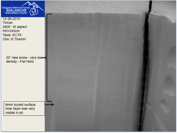
20″ of low density snow sitting on a weak layer of snow below. Today winds and new snow will be adding stress to this weak layer. Be aware of changing conditions.
Recent strong winds combined with 20” of new snow have been adding stress to this unpredictable trigger. Avoid being under cornices and anticipate that these loaded guns will break back into a ridgeline further than expected. Give cornice features a lot of space; should one break it could easily trigger a large slab and send you into dangerous terrain.
Yesterday scattered showers brought another 5 inches of new snow to Turnagain Pass. Winds were light 10-20mph from the East. Rain/snow line was around 500′.
This morning ridgetop Easterly winds are already averaging 28mph at Sunburst weather station. Todays winds are expected to be in the 20-40 mph range with another 3-5 € of new snow. Rain/snow line could be as high as 800′, but temperatures are expected to increase through out the day.
Another large storm is moving into the area this evening bringing strong Easterly winds and more snow. Another 12 € is expected overnight and rain/snow line may rise to 1500′.
Temp Avg (F) | Snow (in) | Water (in) | Snow Depth (in) | |
Center Ridge (1880′) | 29F | 4 | 0.4 | 64 |
Summit Lake (1400′) | 28F | 0 | 0 | 17 |
Alyeska Mid (1700′) | 30F | 5 | 0.46 | 46 |
Temp Avg (F) | Wind Dir | Wind Avg (mph) | Wind Gust (mph) | |
Sunburst (3812′) | 22F | ENE | 18 | 45 |
Seattle Ridge (2400′) | 25F | n/a | n/a | n/a |
Date | Region | Location | Observer |
---|---|---|---|
05/22/23 | Turnagain | Avalanche: Tincan | Nick D'Alessio |
05/12/23 | Turnagain | Avalanche: Tincan, Sunburst, Magnum, Cornbiscuit | Heather Thamm |
05/07/23 | Turnagain | Observation: Tincan – Bear Tracks | CNFAIC Staff |
05/05/23 | Turnagain | Observation: Seattle Ridge | AS/ WW Forecaster |
05/02/23 | Turnagain | Observation: Cornbiscuit | Schauer/ Sturgess Forecaster |
05/02/23 | Turnagain | Observation: Seward Hwy Turnagain Pass | Joel Curtis |
04/30/23 | Turnagain | Observation: Magnum | Ayla, Kit Crosby, Barton |
04/29/23 | Turnagain | Observation: Tincan | John Sykes |
04/28/23 | Turnagain | Avalanche: Taylor Pass/Pastoral | Schauer/ Creighton Forecaster |
04/28/23 | Turnagain | Avalanche: Tincan | Andy Moderow |
Status of riding areas across the Chugach NF is managed by the Glacier and Seward Ranger Districts, not avalanche center staff. Riding area information is posted as a public service to our users and updated based on snow depth and snow density to prevent resource damage at trailhead locations. Riding area questions contact: mailroom_r10_chugach@fs.fed.us
Area | Status | Weather & Riding Conditions |
---|---|---|
Glacier District |
Subscribe to Turnagain Pass
Avalanche Forecast by Email
This is a general backcountry avalanche advisory issued for Turnagain Arm with Turnagain Pass as the core advisory area. This advisory does not apply to highways, railroads or operating ski areas.