Turnagain Pass Avalanche Forecast
|
![]() ![]() |
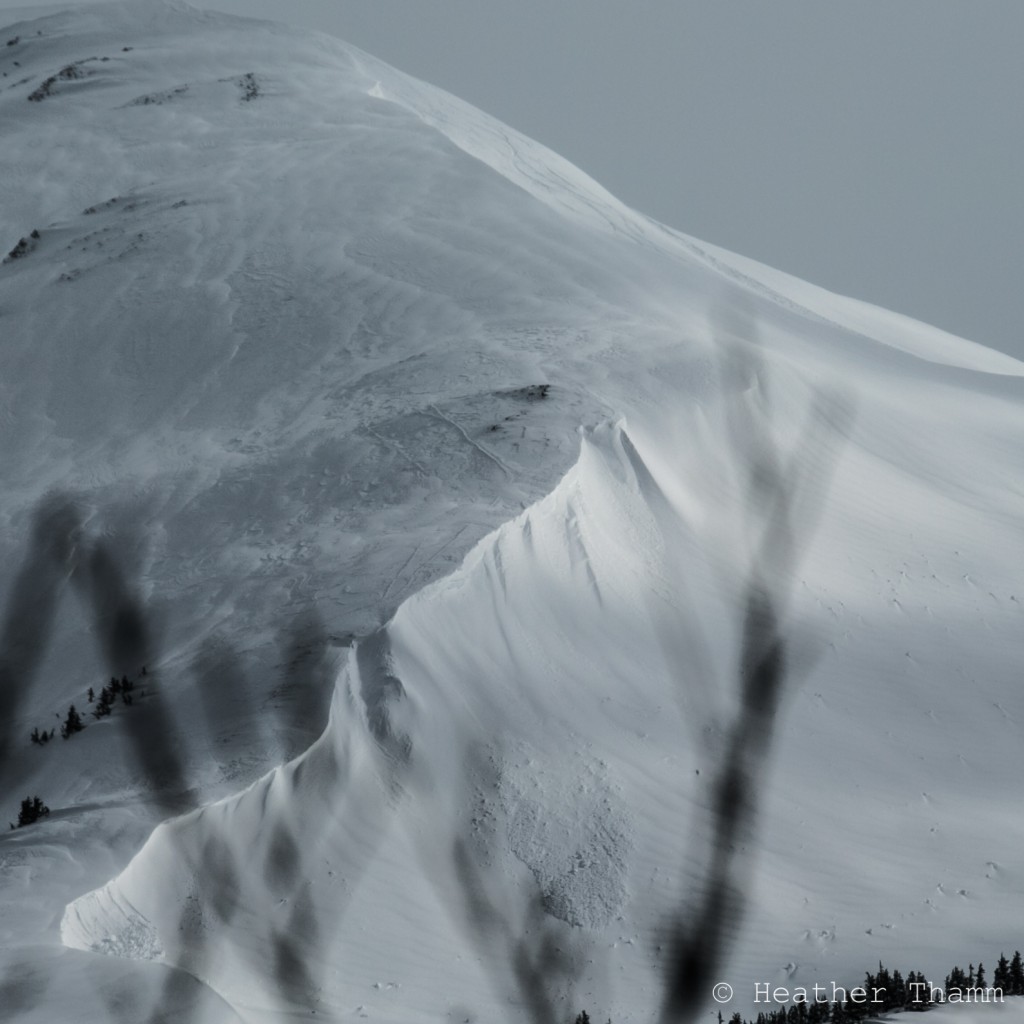
The avalanche danger is CONSIDERABLE today in the alpine after a warm and windy storm moved through south-central Alaska yesterday. 1-3′ of snow combined with strong easterly winds created tender wind slabs and storm slabs in the 2-4′ range. Expect these to still be sensitive. Natural avalanches will be possible and human-triggered avalanche likely again today. Skiing steep slopes (greater than 35 deg.) or direct solar input could be enough of a trigger today for storm slab or wind slab avalanches.
Shaded North aspects are still harboring weak faceted snow where the potential exists for a storm slab to step down and create a large or very large avalanche. Below treeline the avalanche danger is MODERATE.
Careful snowpack evaluation and conservative route finding will be essential if travelling in avalanche terrain today!
Snowboarder-triggered wind/ storm slab avalanche below Tin Can Common (SW aspect) yesterday afternoon.
Come join CNFAIC forecasters at Arctic Man TOMORROW for a FREE Avalanche Rescue Workshop. Not going to Arctic Man this year? Phone a friend who is headed that way and encourage them to attend! We’ll be meeting at the Avalanche Center trailer (near the Trooper post) at Noon.
Wind and precipitation intensity peaked yesterday morning with some instability showers and strong winds persisting through the afternoon hours cross loading slopes and building fresh wind slabs in the alpine. These will be sensitive to human triggers as we are still within 24 hrs of some very active weather that pushed through the advisory area yesterday.
Obvious cross loading on CFR, below Tin Can Common. Predominant wind direction yesterday was from the ENE (right to left in this photo).
Storm totals for yesterday’s quick hitting storm are:
Girdwood Valley: 2.3” of water at Alyeska’s top station (22-26” snow @ 2800’)
1.6” of water at Alyeska’s mid-station (mostly rain/ snow mix @ 1700’)
Turnagain pass (Center ridge): 1.0” of water. (10-12” snow in the alpine, above ~2200’)
Grandview: 1.3” of water. (12-14” snow in the alpine, above ~2200’)
Many aspects (South, East and West) had some sun affect prior to yesterday’s storm providing a slick bed surface for fresh storm slabs to slide upon. Expect slabs to be in the 1-2 foot range around Turnagain pass and up to 2-4’+ in the Girdwood and Portage Valleys. It’ll be best to avoid steep slopes greater than 35 degrees today and let the snowpack adjust to this most recent wind/ loading event. Jumping on small test slopes or digging quick hand pits on your ascent will be a good way to continually assess how well storm snow or wind slabs are bonding (or not) to the underlying bed surface.
Loose Snow avalanches:
If the sun makes an appearance today, expect shallow slabs and loose snow avalanches on sunny aspects from direct solar input. These are likely the same aspects where the underlying crust is most pronounced providing for a slick bed surface.
Cornices:
These continued to grow with yesterday’s storm, creeping ever closer to the point of failure. There is a strong possibility that if a cornice falls on a steep slope, it will initiate a slab avalanche today.
A tale of two seasons exists within our snowpack currently. S, E and W aspects are very spring-like while North aspects are still harboring colder, dry snow where weak facets and old melt/ freeze crusts still exist 2-3’+ below the surface. The potential is there for these layers to re-activate with this current load and a trigger (skier). North-facing slopes are holding a very different structure than the rest of the compass and skiing steep, northerly terrain today is a roll of the dice where consequences may come in the form of a large avalanche. Likely trigger points will be mid-slope or shallow points in the slab near rock outcroppings.
Yesterday morning proved a full on storm day in our region with some impressive winds and precip intensity rates. By early afternoon, much of the rain/ snow had shut off with only lingering instability showers to note though the winds persisted from the ENE. Storm totals ranged from 1-3′ with the rain/ snow line around 2,000′. Girdwood received the Lion’s share of precip with over 2′ of snow at the top of Alyeska. Temperatures peaked in the mid-20’s yesterday morning and slowly slid down a few degrees all day.
Today’s weather looks to be unsettled, but not nearly as stormy as yesterday. We could see 2-4″ of snow above 1,000′ and winds from the SE in the 10-20mph range. Temps will be in the mid-20’s at ridgetops and cooling slightly again this evening.
A front pushing in from the West should arrive late tonight or Thursday morning across south-central. This will fuel more unsettled weather through the weekend though precip amounts and type are still to be determined based on the actual storm track.
Temp Avg (F) | Snow (in) | Water (in) | Snow Depth (in) | |
Center Ridge (1880′) | 33 | 3 | .7 | 61 |
Summit Lake (1400′) | 32 | 2 | .4 | 11 |
Alyeska Mid (1700′) | 33 | 2 | .9 | 35 |
Temp Avg (F) | Wind Dir | Wind Avg (mph) | Wind Gust (mph) | |
Sunburst (3812′) | 23 | ENE | 25 | 66 |
Seattle Ridge (2400′) | 26 | n/a | 25 | 102* |
*Max gust at Seattle ridge is not validated.
Date | Region | Location | Observer |
---|---|---|---|
05/22/23 | Turnagain | Avalanche: Tincan | Nick D'Alessio |
05/12/23 | Turnagain | Avalanche: Tincan, Sunburst, Magnum, Cornbiscuit | Heather Thamm |
05/07/23 | Turnagain | Observation: Tincan – Bear Tracks | CNFAIC Staff |
05/05/23 | Turnagain | Observation: Seattle Ridge | AS/ WW Forecaster |
05/02/23 | Turnagain | Observation: Cornbiscuit | Schauer/ Sturgess Forecaster |
05/02/23 | Turnagain | Observation: Seward Hwy Turnagain Pass | Joel Curtis |
04/30/23 | Turnagain | Observation: Magnum | Ayla, Kit Crosby, Barton |
04/29/23 | Turnagain | Observation: Tincan | John Sykes |
04/28/23 | Turnagain | Avalanche: Taylor Pass/Pastoral | Schauer/ Creighton Forecaster |
04/28/23 | Turnagain | Avalanche: Tincan | Andy Moderow |
Status of riding areas across the Chugach NF is managed by the Glacier and Seward Ranger Districts, not avalanche center staff. Riding area information is posted as a public service to our users and updated based on snow depth and snow density to prevent resource damage at trailhead locations. Riding area questions contact: mailroom_r10_chugach@fs.fed.us
Area | Status | Weather & Riding Conditions |
---|---|---|
Glacier District |
Subscribe to Turnagain Pass
Avalanche Forecast by Email
This is a general backcountry avalanche advisory issued for Turnagain Arm with Turnagain Pass as the core advisory area. This advisory does not apply to highways, railroads or operating ski areas.