Turnagain Pass Avalanche Forecast
|
![]() ![]() |
We continue to have an overall MODERATE avalanche danger for triggering a slab avalanche 1-2′ deep. Areas most likely to find and trigger an avalanche are steep wind loaded slopes on East and South aspects near and above treeline. We had a short lived natural wind slab avalanche cycle yesterday morning associated with strong Northwest winds. More on that below.
Though the main event for yesterday was the wind, our main concern still lies with the potential for triggering an avalanche that fails in the weak snow at the base of the pack. After the past day of cold temperatures, the likelihood for triggering one of these larger slides is decreasing but the problem is not gone – our poor snowpack structure remains and so should our wariness. Keeping with safe travel practices, such as exposing only one person at a time, is wise if venturing onto steep slopes. Yet, if you wish to avoid any avalanche problems all together, stick to gentler terrain 35 degrees or less.
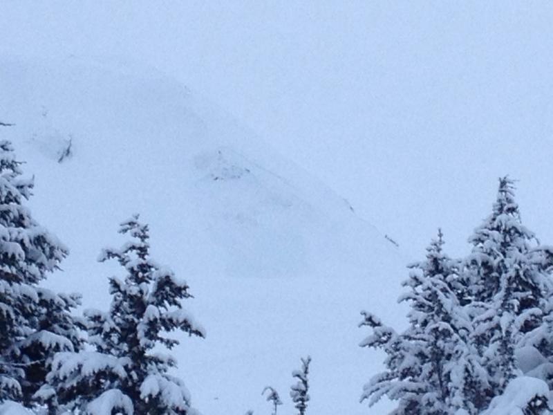
Below is a picture of a couple wind slab avalanches on Seattle Ridge just above the motorized lot that occurred yesterday. It is hard to see but these wind slabs look to have stepped down, or scoured down, into the weak November snow. This highlights our main concern.
Two natural wind slabs on the Southeast face of Seattle Ridge (3,000′).
We had a peak in reactivity for these persistent slabs on Sunday where two human triggered avalanches occurred. At least one of these (on Eddies) was a remote trigger. The other one (on Magnum) is unclear. See the investigation from the Magnum avalanche HERE.
For anyone that was in the Girdwood/Turnagain/Summit zone yesterday morning, it was hard not to notice the high winds ravaging the mountains. Plumes were widespread and so was a short lived wind slab cycle. Below are a few photos from this event. The winds spiked for 3 hours, along with the avalanche activity, then quickly died down for the afternoon.
Today, watch for lingering wind slabs left over from this wind event – most likely on East and South aspects. These should be stiff and stubborn to trigger but still possible – avoid steep slopes with wind drifted and hollow feeling snow. More importantly, the chance of triggering a wind slab that breaks in the deeper weak layers mentioned above is possible – making for a larger slide, similar to the Seattle Ridge avalanche yesterday.
Plumes along peaks and ridges Natural wind slab on East facing Fresno Peak
More details on these avalanches can be found HERE.
Yesterday clear skies and cold temperatures were accompanied by strong Northwest winds. The winds averaged 53mph for 3 hours in the late morning and have since died down and switched to the East early this morning. Temperatures have been in the 0-10F range during the past 24 hours and are just starting to climb out of the single digits.
Today we should see these temperatures reach the mid-teens at most locations, except for valley bottoms, and wind increase to the 10-20mph from the East. A few clouds look to stream in as well as a series of low pressure systems skirts us to our South. We are too far north to get much for snow but we might squeak out a trace to an inch by Christmas morning.
For Christmas this year it looks like we will get a nagging area of high pressure that will bring clear skies and somewhat cold temperatures (teens) through Sunday. Our next shot of precip is not in the foreseeable future.
Date | Region | Location | Observer |
---|---|---|---|
05/22/23 | Turnagain | Avalanche: Tincan | Nick D'Alessio |
05/12/23 | Turnagain | Avalanche: Tincan, Sunburst, Magnum, Cornbiscuit | Heather Thamm |
05/07/23 | Turnagain | Observation: Tincan – Bear Tracks | CNFAIC Staff |
05/05/23 | Turnagain | Observation: Seattle Ridge | AS/ WW Forecaster |
05/02/23 | Turnagain | Observation: Cornbiscuit | Schauer/ Sturgess Forecaster |
05/02/23 | Turnagain | Observation: Seward Hwy Turnagain Pass | Joel Curtis |
04/30/23 | Turnagain | Observation: Magnum | Ayla, Kit Crosby, Barton |
04/29/23 | Turnagain | Observation: Tincan | John Sykes |
04/28/23 | Turnagain | Avalanche: Taylor Pass/Pastoral | Schauer/ Creighton Forecaster |
04/28/23 | Turnagain | Avalanche: Tincan | Andy Moderow |
Status of riding areas across the Chugach NF is managed by the Glacier and Seward Ranger Districts, not avalanche center staff. Riding area information is posted as a public service to our users and updated based on snow depth and snow density to prevent resource damage at trailhead locations. Riding area questions contact: mailroom_r10_chugach@fs.fed.us
Area | Status | Weather & Riding Conditions |
---|---|---|
Glacier District |
Subscribe to Turnagain Pass
Avalanche Forecast by Email
This is a general backcountry avalanche advisory issued for Turnagain Arm with Turnagain Pass as the core advisory area. This advisory does not apply to highways, railroads or operating ski areas.