Turnagain Pass RSS

Archives
ARCHIVED - Forecasts expire after 24 hours.
Issued
Thu, April 18th, 2013 - 7:00AM
Expires
Fri, April 19th, 2013 - 7:00AM
Forecaster
Kevin Wright
Avalanche risk The Bottom Line

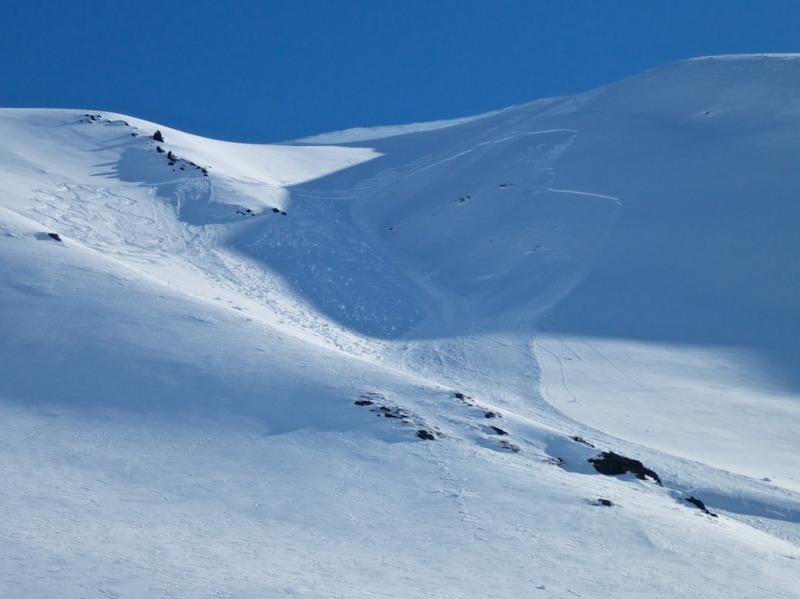
Winter continues in the mountains.   Cold temperatures overnight are keeping the meltdown at bay – for now.   The combination of sunny skies and daytime temperatures reaching above freezing has created pockets of unstable snow across our forecast region.   A rash of small avalanches have been reported over the last week, and that trend will likely continue for the next few days.  

Despite a generally stable snowpack, we need to watch out for shallow slabs that could be triggered by a skier or rider in steep terrain.

Special Announcements

From now until the end of April we will be issuing advisories on the weekends and Tuesday and Thursday  (Sa,Su,Tue,Thur). Keep checking the observations page for information that comes in – during the week especially. And for those getting out, keep the reports coming! The next advisory will be on Thursday, April 18th.

Also, a reminder that Skookum drainage is  closed  to motorized use.

Thu, April 18th, 2013
Alpine
Above 2,500'
2 - Moderate
Avalanche risk
Treeline
1,000'-2,500'
1 - Low
Avalanche risk
Below Treeline
Below 1,000'
1 - Low
Avalanche risk
0 - No Rating
1 - Low
2 - Moderate
3 - Considerable
4 - High
5 - Extreme
Avalanche risk Avalanche risk Avalanche risk Avalanche risk Avalanche risk
Travel Advice Generally safe avalanche conditions. Watch for unstable snow on isolated terrain features. Heightened avalanche conditions on specific terrain features. Evaluate snow and terrain carefully; identify features of concern. Dangerous avalanche conditions. Careful snowpack evaluation, cautious route-finding, and conservative decision-making essential. Very dangerous avalanche conditions. Travel in avalanche terrain not recommended. Extraordinarily dangerous avalanche conditions. Avoid all avalanche terrain.
Likelihood of Avalanches Natural and human-triggered avalanches unlikely. Natural avalanches unlikely; human-triggered avalanches possible. Natural avalanches possible; human-triggered avalanches likely. Natural avalanches likely; human-triggered avalanches very likely. Natural and human-triggered avalanches certain.
Avalanche Size and Distribution Small avalanches in isolated areas or extreme terrain. Small avalanches in specific areas; or large avalanches in isolated areas. Small avalanches in many areas; or large avalanches in specific areas; or very large avalanches in isolated areas. Large avalanches in many areas; or very large avalanches in specific areas. Very large avalanches in many areas.
Avalanche Problem 1
  • Persistent Slabs
    Persistent Slabs
Persistent Slabs
Persistent Slab avalanches are the release of a cohesive layer of snow (a slab) in the middle to upper snowpack, when the bond to an underlying persistent weak layer breaks. Persistent layers include: surface hoar, depth hoar, near-surface facets, or faceted snow. Persistent weak layers can continue to produce avalanches for days, weeks or even months, making them especially dangerous and tricky. As additional snow and wind events build a thicker slab on top of the persistent weak layer, this avalanche problem may develop into a Deep Persistent Slab.
More info at Avalanche.org

The top 2 feet of our snowpack is where the issues can be found.  Depending on aspect the sun has had significant effect to most slopes – either directly on the surface or by creating a series of now buried crusts. 

In general, the better snow can be found on non-south aspects that get less sun exposure.  Watch out for shallow slabs like the ones that we’ve been seeing recently.  Check out the observations page for some examples of what to look out for. 

The avalanches we’ve been seeing have followed a consistent pattern.  Size has been low volume, but they run surprisingly far for the amount of snow involved.  Most aspects are affected, with south having more of a crust/facet issue and north having more of a wind slab issue.  


Picture is from last weekend on the south face of Sunburst.


Avalanche Problem 2
  • Dry Loose
    Dry Loose
Dry Loose
Dry Loose avalanches are the release of dry unconsolidated snow and typically occur within layers of soft snow near the surface of the snowpack. These avalanches start at a point and entrain snow as they move downhill, forming a fan-shaped avalanche. Other names for loose-dry avalanches include point-release avalanches or sluffs.
More info at Avalanche.org

Shaded slopes still hold dry snow at higher elevations.  Those areas are prone to loose snow sluffing by skier initiation.  Just like the slab problem, the volume is relatively small but they can still travel good distances.  

Additional Concern
  • Wet Loose
    Wet Loose
Wet Loose
Wet Loose avalanches are the release of wet unconsolidated snow or slush. These avalanches typically occur within layers of wet snow near the surface of the snowpack, but they may quickly gouge into lower snowpack layers. Like Loose Dry Avalanches, they start at a point and entrain snow as they move downhill, forming a fan-shaped avalanche. Other names for loose-wet avalanches include point-release avalanches or sluffs. Loose Wet avalanches can trigger slab avalanches that break into deeper snow layers.
More info at Avalanche.org

Wet avalanche problems will start soon.  The current pattern of cold overnight temperatures has kept it from becoming an issue, but it’s only a matter of time.  As always this time of year – think about heat induced avalanche activity in the afternoon when the surface crust melts and the snowpack loses strength. 

Weather
Thu, April 18th, 2013

Deja Vu.

Our stretch of sunny weather continues with freezing temperatures overnight and very little wind.  

No snow or rain expected.  Low temperature to 18 degrees, highs expected to reach the high 30s to low 40s at sea level.  NE wind 0-10 mph, with some areas reaching higher speeds near Whittier and Seward.


The next advisory will be issued Saturday, April 20th.  

Observations
Recent Observations for Turnagain Pass
Date Region Location
04/16/24 Turnagain Observation: Cornbiscuit
04/15/24 Turnagain Observation: Taylor Pass
04/15/24 Turnagain Observation: Seward Highway – Tern Lake to Portage
04/14/24 Turnagain Observation: Sunburst
04/14/24 Turnagain Observation: Turnagain Pass Snomo
04/13/24 Turnagain Observation: Spokane Creek
04/11/24 Turnagain Observation: Tincan
04/10/24 Turnagain Avalanche: Seattle Ridge
04/10/24 Turnagain Observation: Cornbiscuit South Face
04/10/24 Turnagain Avalanche: Tincan
Riding Areas

The riding areas page has moved. Please click here & update your bookmarks.


Subscribe to Turnagain Pass
Avalanche Forecast by Email

This is a general backcountry avalanche advisory issued for Turnagain Arm with Turnagain Pass as the core advisory area. This advisory does not apply to highways, railroads or operating ski areas.