Turnagain Pass RSS

Archives
ARCHIVED - Forecasts expire after 24 hours.
Issued
Tue, April 16th, 2013 - 7:00AM
Expires
Wed, April 17th, 2013 - 7:00AM
Forecaster
Wendy Wagner
Avalanche risk The Bottom Line

Much of the terrain around the Eastern Turnagain Arm has a LOW avalanche danger this morning. The exception are pockets of MODERATE danger on upper elevation slopes over 35 degrees for human triggered slab avalanches. The most likely places to find and trigger a slab are areas with prior wind loading at the higher elevations. Additionally, sun induced wet loose and wet slab activity is possible this afternoon on southerly aspects in the case the clouds hold back today.

Special Announcements

From today until the end of April we will be issuing advisories on the weekends and Tuesday and Thursday (Sa,Su,Tue,Thur). Keep checking the observations page for information that comes in – during the week especially. And for those getting out, keep the reports coming! The next advisory will be on Thursday, April 18th.

Also, a reminder that Skookum drainage is closed to motorized use.

Tue, April 16th, 2013
Alpine
Above 2,500'
2 - Moderate
Avalanche risk
Treeline
1,000'-2,500'
1 - Low
Avalanche risk
Below Treeline
Below 1,000'
1 - Low
Avalanche risk
0 - No Rating
1 - Low
2 - Moderate
3 - Considerable
4 - High
5 - Extreme
Avalanche risk Avalanche risk Avalanche risk Avalanche risk Avalanche risk
Travel Advice Generally safe avalanche conditions. Watch for unstable snow on isolated terrain features. Heightened avalanche conditions on specific terrain features. Evaluate snow and terrain carefully; identify features of concern. Dangerous avalanche conditions. Careful snowpack evaluation, cautious route-finding, and conservative decision-making essential. Very dangerous avalanche conditions. Travel in avalanche terrain not recommended. Extraordinarily dangerous avalanche conditions. Avoid all avalanche terrain.
Likelihood of Avalanches Natural and human-triggered avalanches unlikely. Natural avalanches unlikely; human-triggered avalanches possible. Natural avalanches possible; human-triggered avalanches likely. Natural avalanches likely; human-triggered avalanches very likely. Natural and human-triggered avalanches certain.
Avalanche Size and Distribution Small avalanches in isolated areas or extreme terrain. Small avalanches in specific areas; or large avalanches in isolated areas. Small avalanches in many areas; or large avalanches in specific areas; or very large avalanches in isolated areas. Large avalanches in many areas; or very large avalanches in specific areas. Very large avalanches in many areas.
Avalanche Problem 1
  • Persistent Slabs
    Persistent Slabs
Persistent Slabs
Persistent Slab avalanches are the release of a cohesive layer of snow (a slab) in the middle to upper snowpack, when the bond to an underlying persistent weak layer breaks. Persistent layers include: surface hoar, depth hoar, near-surface facets, or faceted snow. Persistent weak layers can continue to produce avalanches for days, weeks or even months, making them especially dangerous and tricky. As additional snow and wind events build a thicker slab on top of the persistent weak layer, this avalanche problem may develop into a Deep Persistent Slab.
More info at Avalanche.org

Though yesterday was a quiet day in the backcounty, we did get a number of late observations from Sunday. The first was a remotely triggered slab on Silvertip Peak (Easterly facing 4,900′). Two on Sunburst – Northerly facing ~3,500′ and on southerly facing ~3,500′ (this south facing slide is a couple days old). And the last, but most noteworthy, in the Girdwood Valley (West facing ~4,100′). Note each of these slabs reported are on each of the 4 aspects.

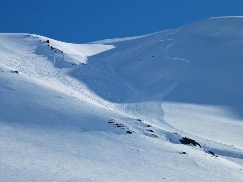
The image below is of the Girdwood Valley avalanche. This was in an area known as Surprise Bowl (see map in link above). Details are still emerging but it seems one party unintentionally triggered an avalanche that caught one of them and partially buried two people from another party while ascending the skin track below. Check the observations page for more reports sent in to us regarding this slide. This incident brings up many topics related to safe travel practices and etiquette when multiple groups are recreating in the same area. There have been a number of close calls regarding multiple groups around the country as well as last year’s accident at Pete’s North. Good habits keep us safer. And that is why even when a slope is littered with tracks and all seems well that we still play one at a time, watch our partners and wait for other goups below (even well below) to pass.


For today – It may be spring and it may have been a week now since our last snowfall, but the cold weather and buried facets surrounding crusts are keeping slab avalanches active. Most of these are old wind slabs that are sitting on a crust with a thin layer of weak snow sandwiched between. That said, we have a persistent slab concern littered about at the upper elevations. On notherly aspects we are seeing smaller shallow wind slabs sitting on old faceted snow but lack the crust bed surface.

The best way to mitigate these slabs is to do quick test pits and hand pits. As well as keep a close eye out for wind loaded slopes and cracking and collapsing (whoomphing). Much of the activity we have seen is in the upper 18″ of the pack. It doesn’t take long to poke in that far. Also, traveling one at time and always having an exit route planned if the slope releases is key.

Avalanche Problem 2
  • Dry Loose
    Dry Loose
Dry Loose
Dry Loose avalanches are the release of dry unconsolidated snow and typically occur within layers of soft snow near the surface of the snowpack. These avalanches start at a point and entrain snow as they move downhill, forming a fan-shaped avalanche. Other names for loose-dry avalanches include point-release avalanches or sluffs.
More info at Avalanche.org

Sluffing in the steeper terrain on shaded aspects should again be expected today. As for the southerly aspects, including many east and westerly slopes, the sun did a number yesterday. Many of these became damp and have refrozen overnight. With today’s daytime heating, pay attention to any softening of surface crusts. In this case, watch for wet loose and shallow wet slabs to become a concern. We are expecting some cloud cover later in the day which could keep surface warming limited.

Additional Concern
  • Cornice
    Cornice
Cornice
Cornice Fall is the release of an overhanging mass of snow that forms as the wind moves snow over a sharp terrain feature, such as a ridge, and deposits snow on the downwind (leeward) side. Cornices range in size from small wind drifts of soft snow to large overhangs of hard snow that are 30 feet (10 meters) or taller. They can break off the terrain suddenly and pull back onto the ridge top and catch people by surprise even on the flat ground above the slope. Even small cornices can have enough mass to be destructive and deadly. Cornice Fall can entrain loose surface snow or trigger slab avalanches.
More info at Avalanche.org

Cornices. Don’t forget to steer well clear of these monsters. They have been baking in the sun each day and are due to come tumbling down any time.

Bears. It seems the bears are waking up. A recently opened den was seen in upper Lyon Creek yesterday, area just north of Pastoral Peak.

Weather
Tue, April 16th, 2013

Yesterday was another clear and pleasant day. Winds stayed light and variable and temperatures rose to the mid 20’sF on the ridges and upper 30’sF at 1,000′. The last measurable snowfall was on April 9th. Overnight, skies have remained clear and temperatures have dropped to the mid teens in most areas with the usual cold pools (i.e., Summit Lake and Portage) in the single digits. Winds have remained light and variable.

Today, our clear skies may be replaced with clouds in the afternoon and maybe even a flurry as a weak low pressure system tries to move in from the Gulf. Winds are forecast to remain light from a northeast direction (5mph on ridgetops). Temperatures look to rise to the 20’sF on the ridgelines and mid 30’sF at 1,000′.

Our dry spell looks to continue for the remainder of the week.


The next advisory will be issued Thursday morning, April 18th.

Observations
Recent Observations for Turnagain Pass
Date Region Location
04/23/24 Turnagain Observation: Turnagain Sunny Side
04/21/24 Turnagain Observation: Bertha Creek
04/20/24 Turnagain Avalanche: Spokane Creek
04/16/24 Turnagain Observation: Cornbiscuit
04/15/24 Turnagain Observation: Taylor Pass
04/15/24 Turnagain Observation: Seward Highway – Tern Lake to Portage
04/14/24 Turnagain Observation: Sunburst
04/14/24 Turnagain Observation: Turnagain Pass Snomo
04/13/24 Turnagain Observation: Spokane Creek
04/11/24 Turnagain Observation: Tincan
Riding Areas

The riding areas page has moved. Please click here & update your bookmarks.


Subscribe to Turnagain Pass
Avalanche Forecast by Email

This is a general backcountry avalanche advisory issued for Turnagain Arm with Turnagain Pass as the core advisory area. This advisory does not apply to highways, railroads or operating ski areas.