Turnagain Pass RSS

Archives
ARCHIVED - Forecasts expire after 24 hours.
Issued
Fri, January 11th, 2013 - 7:00AM
Expires
Sat, January 12th, 2013 - 7:00AM
Forecaster
Wendy Wagner
Avalanche risk The Bottom Line

We continue to have a CONSIDERABLE avalanche danger above treeline on all aspects. Natural avalanches are possible and human triggered avalanches are likely on slopes steeper than 35 degrees. Any avalanche triggered has the potential to be very large and dangerous. Below treeline the danger is MODERATE where it is less likely €“ but still possible – for triggering a slide. Expert level travel skills and conservative terrain choices will be key for staying safe in the backcountry.

Fri, January 11th, 2013
Alpine
Above 2,500'
3 - Considerable
Avalanche risk
Treeline
1,000'-2,500'
2 - Moderate
Avalanche risk
Below Treeline
Below 1,000'
2 - Moderate
Avalanche risk
0 - No Rating
1 - Low
2 - Moderate
3 - Considerable
4 - High
5 - Extreme
Avalanche risk Avalanche risk Avalanche risk Avalanche risk Avalanche risk
Travel Advice Generally safe avalanche conditions. Watch for unstable snow on isolated terrain features. Heightened avalanche conditions on specific terrain features. Evaluate snow and terrain carefully; identify features of concern. Dangerous avalanche conditions. Careful snowpack evaluation, cautious route-finding, and conservative decision-making essential. Very dangerous avalanche conditions. Travel in avalanche terrain not recommended. Extraordinarily dangerous avalanche conditions. Avoid all avalanche terrain.
Likelihood of Avalanches Natural and human-triggered avalanches unlikely. Natural avalanches unlikely; human-triggered avalanches possible. Natural avalanches possible; human-triggered avalanches likely. Natural avalanches likely; human-triggered avalanches very likely. Natural and human-triggered avalanches certain.
Avalanche Size and Distribution Small avalanches in isolated areas or extreme terrain. Small avalanches in specific areas; or large avalanches in isolated areas. Small avalanches in many areas; or large avalanches in specific areas; or very large avalanches in isolated areas. Large avalanches in many areas; or very large avalanches in specific areas. Very large avalanches in many areas.
Avalanche Problem 1
  • Deep Persistent Slabs
    Deep Persistent Slabs
Deep Persistent Slabs
Deep Persistent Slab avalanches are the release of a thick cohesive layer of hard snow (a slab), when the bond breaks between the slab and an underlying persistent weak layer deep in the snowpack. The most common persistent weak layers involved in deep, persistent slabs are depth hoar or facets surrounding a deeply buried crust. Deep Persistent Slabs are typically hard to trigger, are very destructive and dangerous due to the large mass of snow involved, and can persist for months once developed. They are often triggered from areas where the snow is shallow and weak, and are particularly difficult to forecast for and manage.
More info at Avalanche.org

Though there were no new avalanches reported or seen yesterday, we continue to be most concerned with a person triggering a deep and unsurvivable slab avalanche. If there is one type of avalanche that causes more hair pulling and head scratching among snow and avalanche professionals it is the deep slab problem. This is mostly due to the season long slow decline in likelihood of triggering (good) but the increase in size and destructive power (bad).

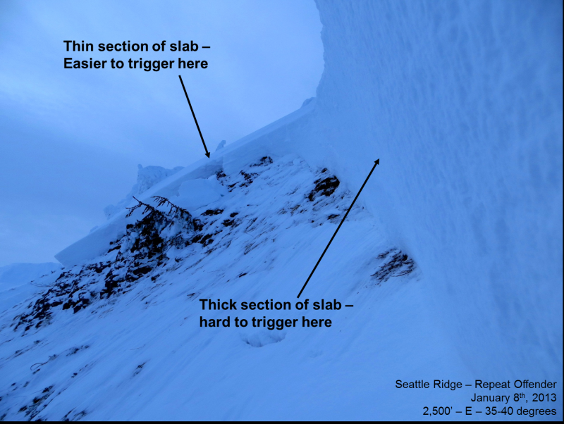
The pack now averages 6 to 8 feet deep and is slowly adjusting to the load that has been placed on it since Christmas. The weak snow from the October and November dry spells make up the problematic weak layers residing in the bottom foot or so. The most likely place to trigger one of these monsters is at a thin area in the slab. These “trigger points” are often around rocks, ridges, rollovers and trees. This is a good thing to keep in mind as we are now at a stage where recent avalanches are often the only “obvious clue” to watch for. We have gotten lucky on two occasions so far – Seattle Ridge January 8th and Tincan January 2nd. These slides were both likely triggered from thin areas of the slab. The message remains: This is an unusual and dangerous year and for riding it out safely, it will require a shift in our backcountry travel practices.

More info is up from the Seattle Ridge Repeat Offender slide. Check out Kevin’s video  from Wednesday and peruse the observation page for several photos. A couple photos below show a view up the slide path and a section of the crown face. A tangle in this would have been deadly.


Avalanche Problem 2
  • Wind Slabs
    Wind Slabs
Wind Slabs
Wind Slab avalanches are the release of a cohesive layer of snow (a slab) formed by the wind. Wind typically transports snow from the upwind sides of terrain features and deposits snow on the downwind side. Wind slabs are often smooth and rounded and sometimes sound hollow, and can range from soft to hard. Wind slabs that form over a persistent weak layer (surface hoar, depth hoar, or near-surface facets) may be termed Persistent Slabs or may develop into Persistent Slabs.
More info at Avalanche.org

Winds have already bumped up this morning from the east on the ridgelines and are averaging 20-30mph with gusts to 50mph. This is the ideal range for forming wind slabs on any slope where today’s wind is depositing snow. Even though forecasted new snow amounts are modest (2-4”), there is still plenty of loose snow existing on the surface for the wind to form sensitive slabs.

Any new wind slab should be discernible by a rounded, pillowy look and the snow will have a stiffer feel than the wind sheltered snow. Watch for cracking around your skis, sled or board. These slabs are likely to be shallow and mostly manageable but if they trigger the deeper weak layers lurking below you could be dealing with a very large and unmanageable avalanche.

Weather
Fri, January 11th, 2013

Those that made it to the Pass yesterday were greeted with mostly clear skies, a light east breeze and a few inches of new snow. Overnight the clouds have moved back in and a trace of snow has fallen while east winds have picked up. We can expect broken cloud cover today with a chance for 2-4 € of snow. Winds will remain out of the east averaging 20-30mph with gusts to 50. Temperatures are on the rise at the lower (mid 30’s) and mid elevations(upper 20’s) but remain near 20F on the ridgelines.

But the big news is we have a wet, warm and wild weekend ahead of us. A large system will pull warm tropical moisture north into our neck of the woods by Sunday into Monday. Many of you have probably seen the NWS special weather statement. It looks like rain will fall above treeline (possibly well above treeline). What this will do to our avalanche conditions will be very interesting so stay tuned as this system develops.

_______________________________________________________________________________________________________

Kevin will issue the next advisory tomorrow morning, January 12th.

Observations
Recent Observations for Turnagain Pass
Date Region Location
03/28/24 Turnagain Observation: Sunburst
03/27/24 Turnagain Observation: Tincan Trees
03/26/24 Turnagain Observation: Cornbiscuit
03/25/24 Turnagain Observation: Tincan
03/22/24 Turnagain Avalanche: Magnum Northwest Aspect
03/21/24 Turnagain Observation: Sunburst
03/21/24 Turnagain Observation: Tincan Proper North Aspect
03/20/24 Turnagain Avalanche: Seattle Creek Drainage
03/19/24 Turnagain Observation: Tincan CFR
03/18/24 Turnagain Avalanche: Tincan – Eddies – Seattle Ridge
Riding Areas

The riding areas page has moved. Please click here & update your bookmarks.


Subscribe to Turnagain Pass
Avalanche Forecast by Email

This is a general backcountry avalanche advisory issued for Turnagain Arm with Turnagain Pass as the core advisory area. This advisory does not apply to highways, railroads or operating ski areas.