Turnagain Pass RSS

Archives
ARCHIVED - Forecasts expire after 24 hours.
Issued
Tue, December 28th, 2021 - 7:00AM
Expires
Wed, December 29th, 2021 - 7:00AM
Forecaster
Wendy Wagner
Avalanche risk The Bottom Line

The avalanche danger remains MODERATE on all aspects and elevations. Warm temperatures again today will make it possible to trigger a wet loose avalanche or a larger more dangerous slab avalanche that could break in buried weak layers. Areas with a shallow snowpack, mostly found on the southern end of the forecast zone, are the most concerning. Much uncertainty exists with the warming and a cautious mindset is prudent.

SUMMIT LAKE:  A shallower and more dangerous snowpack exists in the interior Kenai. Natural avalanches are possible and human triggered avalanches are likely where the snowpack remains warm and/or wet. Cautious route-finding is essential as large slab avalanches, breaking in buried weak layers, could occur.

Roof avalanches:  Warming temperatures today with some light rain possible this evening may cause roofs to shed their snow. Keep an eye out for children and pets.

Special Announcements
Tue, December 28th, 2021
Alpine
Above 2,500'
2 - Moderate
Avalanche risk
Treeline
1,000'-2,500'
2 - Moderate
Avalanche risk
Below Treeline
Below 1,000'
2 - Moderate
Avalanche risk
0 - No Rating
1 - Low
2 - Moderate
3 - Considerable
4 - High
5 - Extreme
Avalanche risk Avalanche risk Avalanche risk Avalanche risk Avalanche risk
Travel Advice Generally safe avalanche conditions. Watch for unstable snow on isolated terrain features. Heightened avalanche conditions on specific terrain features. Evaluate snow and terrain carefully; identify features of concern. Dangerous avalanche conditions. Careful snowpack evaluation, cautious route-finding, and conservative decision-making essential. Very dangerous avalanche conditions. Travel in avalanche terrain not recommended. Extraordinarily dangerous avalanche conditions. Avoid all avalanche terrain.
Likelihood of Avalanches Natural and human-triggered avalanches unlikely. Natural avalanches unlikely; human-triggered avalanches possible. Natural avalanches possible; human-triggered avalanches likely. Natural avalanches likely; human-triggered avalanches very likely. Natural and human-triggered avalanches certain.
Avalanche Size and Distribution Small avalanches in isolated areas or extreme terrain. Small avalanches in specific areas; or large avalanches in isolated areas. Small avalanches in many areas; or large avalanches in specific areas; or very large avalanches in isolated areas. Large avalanches in many areas; or very large avalanches in specific areas. Very large avalanches in many areas.
Recent Avalanches

No avalanches occurred yesterday that we know of.

We did get more information on some natural avalanches that did occur two days ago, on Sunday. This was the first day of the warm up.

  • Twin Peaks on the southern edge of our forecast zone, more shallow snowpack. Natural large slab on the NE face of Twin Peaks (photo below). Triggered likely by both strong westerly wind and warm temperatures on 12.26.

These three avalanches were in the interior Kenai, harboring a very shallow snowpack, and to the south of the forecast zone:

  • Fresno ridge and Colorado Pk, in Summit Lake. These two were also likely triggered by the strong westerly wind and warm temperatures weakening and overloading the poor snowpack. The Fresno slide, pictured below, was around ~2,800′ wide and broke in buried weak layers.
  • Cooper Landing area. A skier booting up a slide path was washed over by a natural wet avalanche from above. The first wave of snow hit the skier, before they were able to move to the side of the path when the heavier and denser wet debris rolled by. Unknown if this was a wet slab or large wet loose avalanche.


Natural avalanche on Twin Peaks, likely released 12.26.21. This one looks like it was triggered by a small wet loose avalanche that released just above the deepest part of the crown tucked up in the rocks just to the left of the center of the frame. Photo taken 12.27.2021.

Large natural avalanche on Fresno, likely occurred during Sunday’s (12.26.21) strong westerly winds. Avalanche up to 2,800′ wide and suspected to break in advanced facets buried around 2′ deep. Photo taken 12.27.2021.

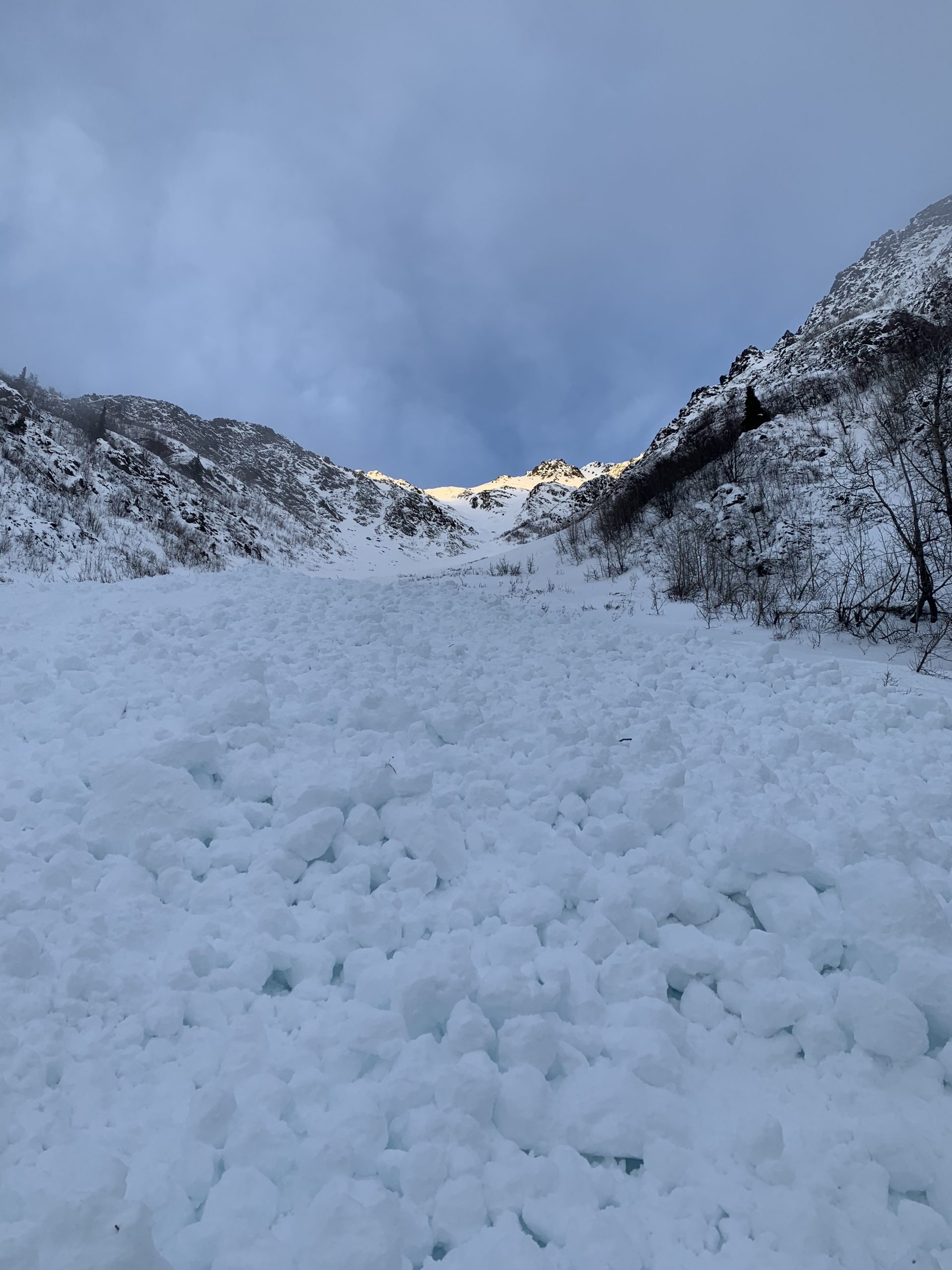
Natural wet avalanche that released on Sunday when a skier was lower on the snow. Skier was able to get out of the way after being washed over by a first wave of snow. Photo by skier, 12.26.21.

Avalanche Problem 1
  • Deep Persistent Slabs
    Deep Persistent Slabs
  • Certain
    Very Likely
    Likely
    Possible
    Unlikely
    Likelihood
  • Historic (D4-5)
    Very Large (D3)
    Large (D2)
    Small (D1)
    Size
Deep Persistent Slabs
Deep Persistent Slab avalanches are the release of a thick cohesive layer of hard snow (a slab), when the bond breaks between the slab and an underlying persistent weak layer deep in the snowpack. The most common persistent weak layers involved in deep, persistent slabs are depth hoar or facets surrounding a deeply buried crust. Deep Persistent Slabs are typically hard to trigger, are very destructive and dangerous due to the large mass of snow involved, and can persist for months once developed. They are often triggered from areas where the snow is shallow and weak, and are particularly difficult to forecast for and manage.

Likelihood of Avalanches
Terms such as "unlikely", "likely", and "certain" are used to define the scale, with the chance of triggering or observing avalanches increasing as we move up the scale. For our purposes, "Unlikely" means that few avalanches could be triggered in avalanche terrain and natural avalanches are not expected. "Certain" means that humans will be able to trigger avalanches on many slopes, and natural avalanches are expected.

Size of Avalanches
Avalanche size is defined by the largest potential avalanche, or expected range of sizes related to the problem in question. Assigned size is a qualitative estimate based on the destructive classification system and requires specialists to estimate the harm avalanches may cause to hypothetical objects located in the avalanche track (AAA 2016, CAA 2014). Under this schema, "Small" avalanches are not large enough to bury humans and are relatively harmless unless they carry people over cliffs or through trees or rocks. Moving up the scale, avalanches become "Large" enough to bury, injure, or kill people. "Very Large" avalanches may bury or destroy vehicles or houses, and "Historic" avalanches are massive events capable of altering the landscape.

Signal Word Size (D scale) Simple Descriptor
Small 1 Unlikely to bury a person
Large 2 Can bury a person
Very Large 3 Can destroy a house
Historic 4 & 5 Can destroy part or all of a village
More info at Avalanche.org

Well… it looks like one more day of this wild warm weather before things start to cool off tomorrow. The warmest temperatures have been at the upper elevations (30-40F) for two days now. This has melted the surface and formed a thin wet (or crusty) layer capping the snowpack from valley bottoms to ridgetops. Temperatures have cooled overnight under clear(ish) skies, but with continued warm ambient air along with clouds forecast this afternoon with some light rain, the surface crusts should soften through the day.

This dramatic warm up has not produced any avalanche activity that we know of in Turnagain Pass or areas that have a thick snowpack (around 6′ or more). But… it has been able to affect the shallow snowpack areas, which mostly lie just outside the forecast zone (i.e. Summit Lake). These are the areas to be most suspect of until the pack freezes up. As we can see in Andrew’s report from Fresno, the first day of the warm up (Sunday), which coincided with strong westerly winds, produced some significant avalanche activity that broke in weak layers only buried around 2′ deep.

Things to think about for today are:

  • Are you in an area that has a thick snowpack or a thin snowpack?
  • If you are in a thin snowpack, it’s best to steer clear of steep slopes and not mess with avalanche terrain.
  • What are the snow surface conditions? Crusty or wet?
  • If the surface is wet, how wet? Potentially wet enough to trigger a wet loose avalanche on a steep slope? Maybe late today if a little rain does fall.
  • Look for any signs of instability or avalanches that have occurred in the past two days. Avoid similar slopes if you see any signs of recent avalanches.

The faceted layers that sit above the Halloween crust are still there of course, as shown in the pit from Seattle Ridge below. They continue to show signs of being squished and strengthening in those thicker snowpack areas, but we are still looking out for any signs showing otherwise. Right now, all signs point to where those facets are weaker and closer to the surface, hence the shallow zones.


Snowpack structure at 2,800′ above Main Bowl on a NE facing slope. Total snow depth was 7 feet. We could not get the weak layer to fail in this location. 12.27.21.


Glide Avalanches:  Some glide cracks are re-opening around the region. Keep your eye out for them. This one below is from Seattle Ridge in Warmup Bowl.

Glide crack on Seattle Ridge’s Warmup Bowl that is opening back up. 12.27.21.

Weather
Tue, December 28th, 2021

Yesterday:  Mostly cloudy skies were over the region. Temperatures were very warm, in the upper 30’sF along ridgelines and near 32F in valley bottoms. Ridgetop winds were generally from the NW in the 5-10mph with gusts into the 30’s at times.

Today:  Mostly clear skies with valley fog is expected to start the day. Later this afternoon, clouds are forecast to fill in with a chance for a trace to .2″ of rain possible this evening. Temperatures are again inverted this morning with ridgetops in the mid 30’sF and valley bottoms in the 20’sF. Highs today should be in the upper 30’sF at all elevations. Ridgetop winds will be 5-15mph from the west to northwest and increasing some tonight with the rainfall.

Tomorrow:  Finally cooler air begins to filter in early tomorrow morning. Mostly sunny skies are forecast with breezy NW winds. Temperatures should be near 30F at the low elevations and in the 20’sF along the ridgelines.

PRECIPITATION 24-hour data (6am – 6am)

Temp Avg (F) Snow (in) Water (in) Snow Depth (in)
Center Ridge (1880′) 38 0 0 67
Summit Lake (1400′) 33 0 0 22
Alyeska Mid (1700′) 35 0 0 40

RIDGETOP 24-hour data (6am – 6am)

Temp Avg (F) Wind Dir Wind Avg (mph) Wind Gust (mph)
Sunburst (3812′) 33 NW 8 34
Seattle Ridge (2400′) 34 NW 7 16
Observations
Recent Observations for Turnagain Pass
Date Region Location
04/16/24 Turnagain Observation: Cornbiscuit
04/15/24 Turnagain Observation: Taylor Pass
04/15/24 Turnagain Observation: Seward Highway – Tern Lake to Portage
04/14/24 Turnagain Observation: Sunburst
04/14/24 Turnagain Observation: Turnagain Pass Snomo
04/13/24 Turnagain Observation: Spokane Creek
04/11/24 Turnagain Observation: Tincan
04/10/24 Turnagain Avalanche: Seattle Ridge
04/10/24 Turnagain Observation: Cornbiscuit South Face
04/10/24 Turnagain Avalanche: Tincan
Riding Areas

The riding areas page has moved. Please click here & update your bookmarks.


Subscribe to Turnagain Pass
Avalanche Forecast by Email

This is a general backcountry avalanche advisory issued for Turnagain Arm with Turnagain Pass as the core advisory area. This advisory does not apply to highways, railroads or operating ski areas.