Turnagain Pass Avalanche Forecast RSS

Archives
ARCHIVED FORECAST - All forecasts expire after 24 hours from the posting date/time.
Issued
Sat, December 26th, 2020 - 7:00AM
Expires
Sun, December 27th, 2020 - 7:00AM
Forecaster
Wendy Wagner
Avalanche risk The Bottom Line

The avalanche danger is MODERATE at elevations above 1,000′ where triggering a lingering wind slab avalanche is possible. These slabs could be fairly stubborn, composed of hard snow and in the 6-24″ range. They are likely to be found on steeper slopes, rollovers and in cross-loaded gullies. The danger is LOW below 1,000′.

SUMMIT LAKE: The snowpack in the central Kenai Mts is shallow and above 2,500′ an outlier avalanche breaking in old buried weak layers is still on our radar.

Special Announcements
Thanks to our sponsors!
Sat, December 26th, 2020
Alpine
Above 2,500'
Moderate (2)
Avalanche risk
Treeline
1,000'-2,500'
Moderate (2)
Avalanche risk
Below Treeline
Below 1,000'
Low (1)
Avalanche risk
Alpine
Above 2,500'
Avalanche risk
Moderate (2)
Treeline
1,000'-2,500'
Avalanche risk
Moderate (2)
Below Treeline
Below 1,000'
Avalanche risk
Low (1)
Danger Scale:
No Rating (0)
Low (1)
Moderate (2)
Considerable (3)
High (4)
Extreme (5)
Avalanche Problem 1
  • Wind Slabs
    Wind Slabs
  • Almost Certain
    Very Likely
    Likely
    Possible
    Unlikely
    Likelihood
  • Historic (D4-5)
    Very Large (D3)
    Large (D2)
    Small (D1)
    Size
Wind Slabs
Wind Slab avalanches are the release of a cohesive layer of snow (a slab) formed by the wind. Wind typically transports snow from the upwind sides of terrain features and deposits snow on the downwind side. Wind slabs are often smooth and rounded and sometimes sound hollow, and can range from soft to hard. Wind slabs that form over a persistent weak layer (surface hoar, depth hoar, or near-surface facets) may be termed Persistent Slabs or may develop into Persistent Slabs.

Likelihood of Avalanches
Terms such as "unlikely", "likely", and "certain" are used to define the scale, with the chance of triggering or observing avalanches increasing as we move up the scale. For our purposes, "Unlikely" means that few avalanches could be triggered in avalanche terrain and natural avalanches are not expected. "Certain" means that humans will be able to trigger avalanches on many slopes, and natural avalanches are expected.

Size of Avalanches
Avalanche size is defined by the largest potential avalanche, or expected range of sizes related to the problem in question. Assigned size is a qualitative estimate based on the destructive classification system and requires specialists to estimate the harm avalanches may cause to hypothetical objects located in the avalanche track (AAA 2016, CAA 2014). Under this schema, "Small" avalanches are not large enough to bury humans and are relatively harmless unless they carry people over cliffs or through trees or rocks. Moving up the scale, avalanches become "Large" enough to bury, injure, or kill people. "Very Large" avalanches may bury or destroy vehicles or houses, and "Historic" avalanches are massive events capable of altering the landscape.

Signal Word Size (D scale) Simple Descriptor
Small 1 Unlikely to bury a person
Large 2 Can bury a person
Very Large 3 Can destroy a house
Historic 4 & 5 Can destroy part or all of a village
More info at Avalanche.org

With a quiet weather day on tap today (cloudy skies, an inch of new snow and light variable winds), our main avalanche concern lies with lingering wind slabs that either formed early yesterday morning or during the high winds on Tuesday. These lingering slabs could be hidden under a skiff of new snow and found lower on the slope than expected, for example below mid-slope rollovers or in cross-loaded gullies. They are also generally on the harder side, which could allow them to not break until a person is further out on the slope. The higher in elevation one goes, and into more exposed wind affected zones, the more likely wind slabs will be lurking. Although these were fairly stubborn yesterday and should be on their way to bonding more today, it is still something to keep a close eye out for.

If visibility is good enough to get to the steeper slopes, watch for the classic wind slab signs:

  • hollow, or drum like, feeling snow?
  • stiff snow over soft snow?
  • cracks in the snow around you that shoot out?

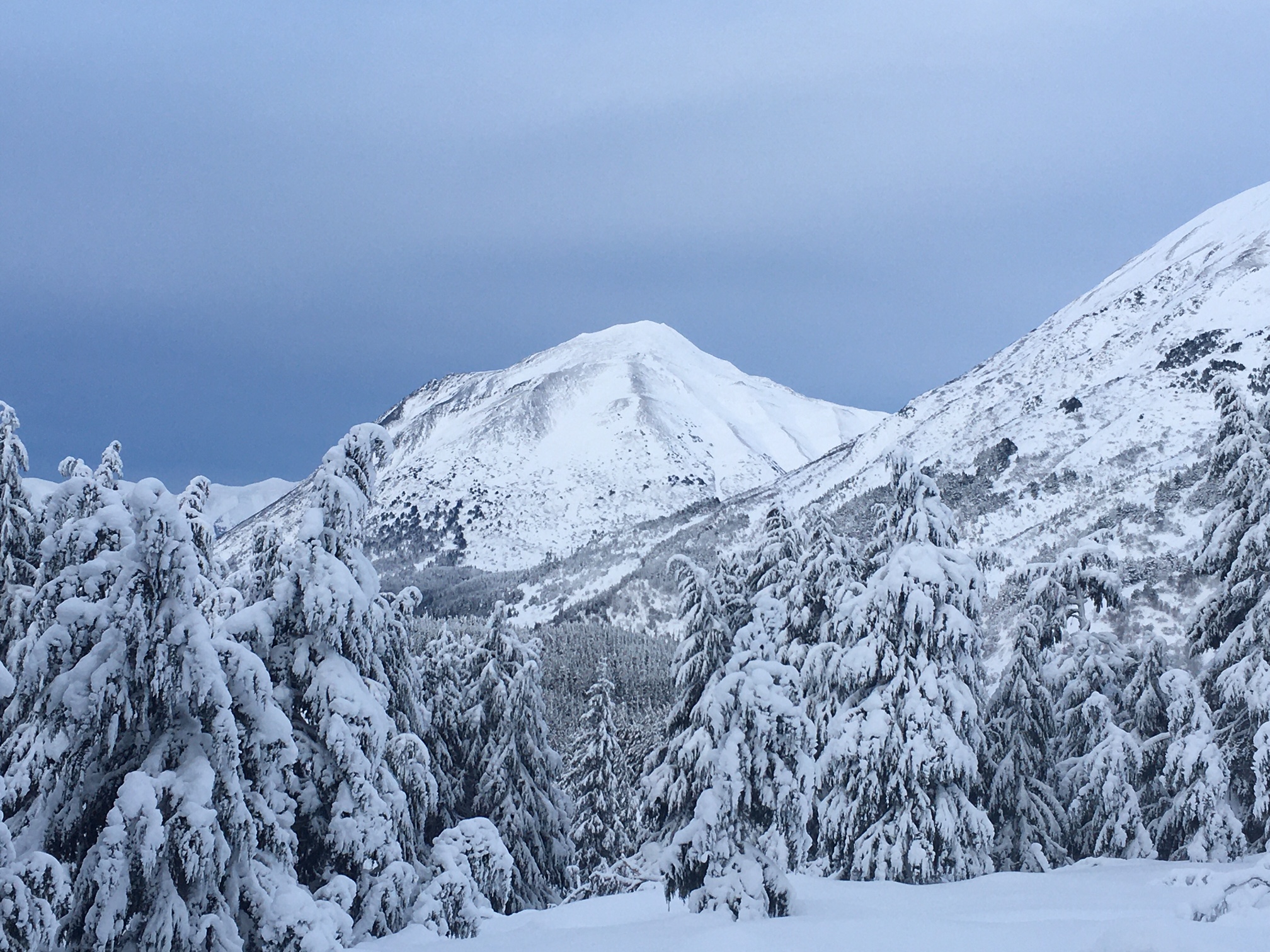
Very Chistmasy in the mountains yesterday! This photo shows significant wind effect on Peak 4940 that is across from the Johnson Pass trailhead and the furthest point of Seattle Ridge. 12.25.20

Additional Concern
  • Deep Persistent Slabs
    Deep Persistent Slabs
Deep Persistent Slabs
Deep Persistent Slab avalanches are the release of a thick cohesive layer of hard snow (a slab), when the bond breaks between the slab and an underlying persistent weak layer deep in the snowpack. The most common persistent weak layers involved in deep, persistent slabs are depth hoar or facets surrounding a deeply buried crust. Deep Persistent Slabs are typically hard to trigger, are very destructive and dangerous due to the large mass of snow involved, and can persist for months once developed. They are often triggered from areas where the snow is shallow and weak, and are particularly difficult to forecast for and manage.
More info at Avalanche.org

To the south of our forecast area in the Summit Lake region a much shallower snowpack exists compared with Turnagain Pass. Here there are old facets at the bottom of the snowpack and some old mid-pack weak layers. At elevations above 2500’ where there are no mid-pack crusts and the slab is composed of hard snow, these weak layers give us some pause. As the days go on and snowpit tests continue to show the layers loosing reactivity, the question is, can a dangerous avalanche be triggered if someone hits just the wrong thin spot? This is an outlier situation, but something I still have in the back of my mind.

Weather
Sat, December 26th, 2020

Yesterday:  High clouds with some patches of blue sky filtered through yesterday. Ridgetop winds were easterly averaging 10-20mph with a few gusts into the 30’s. Temperatures were in the 20’s F at mid and upper elevations.

Today:  Cloudy skies with light snow showers are forecast today. Only 1-3″ of accumulation is expected – from sea level and up. Ridgetop winds are light easterly (~5mph) this morning and should swing around to the west through the day and remain in the 5-10mph range. Temperatures should stay in the 20’s F at mid and upper elevations while sea level remains near 32F

Tomorrow:  For Sunday, strong ridgetop easterly winds are forecast to develop ahead of a large low pressure system headed our way. Skies should be cloudy and precipitation associated with this front should begin Sunday night and extent through the early part of the week. This system is somewhat warm, but so far the rain/snow line looks to remain below 1,000′. Stay tuned!

PRECIPITATION 24-hour data (6am – 6am)

Temp Avg (F) Snow (in) Water (in) Snow Depth (in)
Center Ridge (1880′) 27 0 0 77
Summit Lake (1400′) 22 0 0 31
Alyeska Mid (1700′) 26 0 0 77

RIDGETOP 24-hour data (6am – 6am)

Temp Avg (F) Wind Dir Wind Avg (mph) Wind Gust (mph)
Sunburst (3812′) 23 NE 14 39
Seattle Ridge (2400′) 23 *N/A *N/A *N/A

*Seattle Ridge anemometer is rimed over and not reporting wind data.

Observations
Recent Observations for Turnagain Pass
Date Region Location
05/22/23 Turnagain Avalanche: Tincan
05/12/23 Turnagain Avalanche: Tincan, Sunburst, Magnum, Cornbiscuit
05/07/23 Turnagain Observation: Tincan – Bear Tracks
05/05/23 Turnagain Observation: Seattle Ridge
05/02/23 Turnagain Observation: Cornbiscuit
05/02/23 Turnagain Observation: Seward Hwy Turnagain Pass
04/30/23 Turnagain Observation: Magnum
04/29/23 Turnagain Observation: Tincan
04/28/23 Turnagain Avalanche: Taylor Pass/Pastoral
04/28/23 Turnagain Avalanche: Tincan
Riding Areas
Updated Thu, June 01st, 2023

Status of riding areas across the Chugach NF is managed by the Glacier and Seward Ranger Districts, not avalanche center staff. Riding area information is posted as a public service to our users and updated based on snow depth and snow density to prevent resource damage at trailhead locations. Riding area questions contact: mailroom_r10_chugach@fs.fed.us

Area Status Weather & Riding Conditions
Glacier District
Johnson Pass
Closed
Closed May 15.
Placer River
Closed
Closed May 15.
Skookum Drainage
Closed
Will close to motorized use on April 1, 2023 per the National Forest Plan.
Turnagain Pass
Closed
Will close on June 1.
Twentymile
Closed
Scheduled closure May 1.
Seward District
Carter Lake
Closed
Scheduled closure May 1.
Lost Lake Trail
Closed
Scheduled closure May 1.
Primrose Trail
Closed
Scheduled closure May 1.
Resurrection Pass Trail
Closed
Closed to motorized use for the 2022/23 winter season per Forest Plan. Open next season.
Snug Harbor
Closed
Extended opening until May 15.
South Fork Snow River Corridor
Closed
Scheduled closure May 1.
Summit Lake
Closed
Scheduled closure May 1.

Subscribe to Turnagain Pass
Avalanche Forecast by Email

This is a general backcountry avalanche advisory issued for Turnagain Arm with Turnagain Pass as the core advisory area. This advisory does not apply to highways, railroads or operating ski areas.