Turnagain Pass |
Archives |
The avalanche danger is CONSIDERABLE in areas being impacted by the strong northwest winds, predominantly above 2,500′. Just after midnight, ridgetop winds increased dramatically. Any new wind slab will likely be easy to trigger by us and may release naturally. Watch for signs of recent, or active, wind loading. Otherwise, on all slopes above 1,000′, there is a MODERATE avalanche danger where a person could still trigger a larger slab, 2 to 5+ feet deep, that breaks in old buried weak layers.
Below 1,000, the danger is LOW where triggering an avalanche is unlikely.
Travel Advice | Generally safe avalanche conditions. Watch for unstable snow on isolated terrain features. | Heightened avalanche conditions on specific terrain features. Evaluate snow and terrain carefully; identify features of concern. | Dangerous avalanche conditions. Careful snowpack evaluation, cautious route-finding, and conservative decision-making essential. | Very dangerous avalanche conditions. Travel in avalanche terrain not recommended. | Extraordinarily dangerous avalanche conditions. Avoid all avalanche terrain. |
Likelihood of Avalanches | Natural and human-triggered avalanches unlikely. | Natural avalanches unlikely; human-triggered avalanches possible. | Natural avalanches possible; human-triggered avalanches likely. | Natural avalanches likely; human-triggered avalanches very likely. | Natural and human-triggered avalanches certain. |
Avalanche Size and Distribution | Small avalanches in isolated areas or extreme terrain. | Small avalanches in specific areas; or large avalanches in isolated areas. | Small avalanches in many areas; or large avalanches in specific areas; or very large avalanches in isolated areas. | Large avalanches in many areas; or very large avalanches in specific areas. | Very large avalanches in many areas. |
Signal Word | Size (D scale) | Simple Descriptor |
Small | 1 | Unlikely to bury a person |
Large | 2 | Can bury a person |
Very Large | 3 | Can destroy a house |
Historic | 4 & 5 | Can destroy part or all of a village |
Happy Winter Solstice, everyone! A quick shot of snowfall was over the region yesterday. Girdwood, Placer Valley, and Turnagain Pass all saw around 3-5″ of new snow, including to the south of Turnagain Pass. Although this is a nice refresh, maybe not so much above the trees as right around 2am this morning those pesky northwest winds really ramped up.
The Sunburst weather station, which doesn’t pick up this wind direction very well, saw a gust to 48mph. The AKRR Milepost 43 station, which does pick up these winds well, recorded a gust of 70mph at 4am. That said, average winds have been around 20mph, just right for moving snow. The wind should remain through the day and diminish somewhat before increasing again tonight.
Fresh wind slabs should be easy to find and trigger on those slopes that see recent or active wind loading. Natural winds slabs are possible as well in these windy locations. If you are headed out today, watch for those signs of wind loading, cracking in the snow around you and feel for stiffer snow over softer snow. These northwest winds have unusual loading patterns. They can funnel through Turnagain Pass in a way that produces a south wind on the east (non-moto) side of Turnagain Pass, which creates loading on the north side of the ridges. The winds can also split around Turnagain Pass, saving it from too much wind damage in general, but it’s too early to tell if this will be the case.
The good news is, we should be able to easily use our observation skills to suss out whether the winds have, or are, moving snow around in the area we choose to travel. If there is no wind effect, then we are dealing with that annoying persistent weak layer 2 to 5 feet down or any old wind slab that could be lingering from days ago.
Signal Word | Size (D scale) | Simple Descriptor |
Small | 1 | Unlikely to bury a person |
Large | 2 | Can bury a person |
Very Large | 3 | Can destroy a house |
Historic | 4 & 5 | Can destroy part or all of a village |
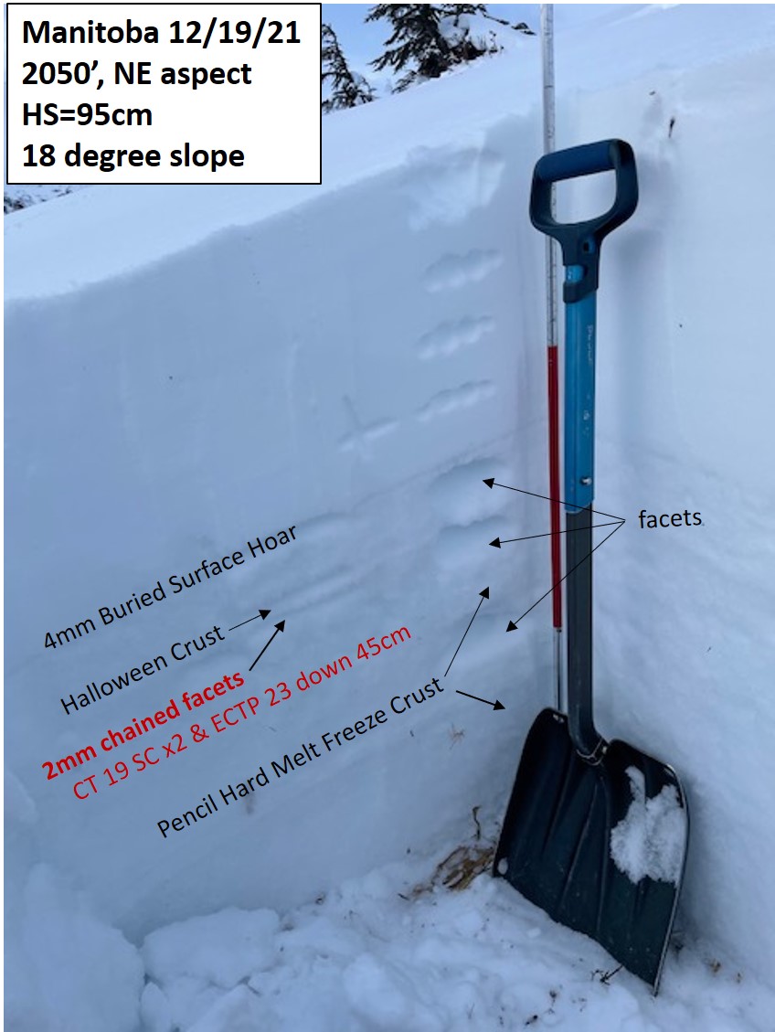
That’s right, we are still talking about those old faceted layers from early November that are buried anywhere from 2 to 5+ feet deep. It has been just about 10 days now since they were last producing avalanches. That was on the tail end of the last snowfall on Dec 9-10. Many of us have been digging down to these layers, especially where they are shallower (around 3 feet or less) and testing them. They are doing what a ‘deep persistent slab’ problem does, which is the facets are getting harder (good) and the layer takes more force to make it fail (also good). But, that doesn’t mean we are out of the woods.
There is still a chance someone could hit a thin spot and create a large avalanche. That likelihood is becoming less as the days go by, but still something we all should keep in mind, especially when venturing to new areas. Some areas, such as the Placer Valley in the video below, have a much larger slab while others, more on the south end of Turnagain Pass, have a much shallower slab. The shallower the snowpack, the thinner the slab, and the more likely it is we can cause the weak layers to fail and potentially cause an avalanche.
Snow pit at 2,050′ in the Summit Lake area that has a shallower snowpack, just to the south of the advisory area. A large whumpf was experienced at this location, evidence that the facets are able to collapse with the weight of a person(s). Photo: Andy Moderow, 12.19.21.
Yesterday: Cloudy skies, light snowfall and warm temperatures were over the region. Between 3-5″ of snowfall was seen in most areas, with snow to sea level. Ridgetop winds were light (5-10mph) from the west. Temperatures rose to the mid to upper 20’sF at all elevations (including the ridgetops) where they have remained.
Today: Early this morning the NW winds picked up dramatically into the 25mph range with gusts near 50mph. This is in conjunction with clearing skies and cooling temperatures. Ridgetop winds are forecast to remain in the 20-25mph range through the day. Temperatures are on a slow decline back to the teens for this evening along with clear skies.
Tomorrow: Partly cloudy skies, light NW winds and temperatures in the teens are on tap for tomorrow. Another bump in NW winds may shape up for tomorrow night into Thursday. It looks like it will be after Christmas till there is another shot for snow.
PRECIPITATION 24-hour data (6am – 6am)
Temp Avg (F) | Snow (in) | Water (in) | Snow Depth (in) | |
---|---|---|---|---|
Center Ridge (1880′) | 26 | 3 | 0.4 | 71 |
Summit Lake (1400′) | 22 | 3 | 0.3 | N/A |
Alyeska Mid (1700′) | 24 | 4 | 0.4 | 44 |
RIDGETOP 24-hour data (6am – 6am)
Temp Avg (F) | Wind Dir | Wind Avg (mph) | Wind Gust (mph) | |
---|---|---|---|---|
Sunburst (3812′) | 23 | NW | 10 | 48 |
Seattle Ridge (2400′) | 22 | NW | 15 | 39 |
Date | Region | Location | Observer |
---|---|---|---|
05/13/24 | Turnagain | Observation: Eddie’s, Sunburst, Seattle, Cornbiscuit, Pete’s South | H Thamm |
05/13/24 | Turnagain | Observation: Turnagain Pass non-motorized side | Amy Holman |
05/12/24 | Turnagain | Observation: Warm up Bowl | Tony Naciuk |
05/07/24 | Turnagain | Observation: Turnagain Pass Wet Slabs | A S |
04/29/24 | Turnagain | Avalanche: Turnagain aerial obs | Tully Hamer |
04/27/24 | Turnagain | Observation: Johnson Pass | Noah Mery |
04/23/24 | Turnagain | Observation: Turnagain Sunny Side | Travis SMITH |
04/21/24 | Turnagain | Observation: Bertha Creek | Anonymous |
04/20/24 | Turnagain | Avalanche: Spokane Creek | Schauer/ Mailly Forecaster |
04/16/24 | Turnagain | Observation: Cornbiscuit | Krueger / Matthys Forecaster |
The riding areas page has moved. Please click here & update your bookmarks.
Subscribe to Turnagain Pass
Avalanche Forecast by Email