Turnagain Pass Avalanche Forecast RSS

Archives
ARCHIVED FORECAST - All forecasts expire after 24 hours from the posting date/time.
Issued
Wed, December 16th, 2020 - 7:00AM
Expires
Thu, December 17th, 2020 - 7:00AM
Forecaster
Andrew Schauer
Avalanche risk The Bottom Line

Today’s avalanche danger is MODERATE at elevations above 2500’. Although unlikely, there is still a chance a person could trigger a large avalanche 6’ deep or deeper failing in weak snow at the ground. Be careful with your terrain choices, and avoid thin, rocky areas where it will be most likely to trigger an avalanche. The avalanche danger is LOW at elevations below 2500’.

SUMMIT LAKE: The snowpack in the Summit Lake area is generally thinner and weaker, making it easier to trigger a deep slab avalanche near the ground. Be cautious with your terrain choices, and avoid steep, rocky terrain where these avalanches will be most likely.

Special Announcements

Member Gear Giveaway: To show appreciation for current members and new members that sign up by January 15, the Friends of the CNFAIC will give away three pairs of skis in a drawing on January 16. Please encourage friends and family to go to our website’s Sponsors & Members page and sign up. For as little as $20 your name will be added to the members list, and you’ll be eligible for the ski drawing! Thanks to Ski AK for donating the skis, and to all of you for supporting your local avalanche center.

Thanks to our sponsors!
Wed, December 16th, 2020
Alpine
Above 2,500'
Moderate (2)
Avalanche risk
Treeline
1,000'-2,500'
Low (1)
Avalanche risk
Below Treeline
Below 1,000'
Low (1)
Avalanche risk
Alpine
Above 2,500'
Avalanche risk
Moderate (2)
Treeline
1,000'-2,500'
Avalanche risk
Low (1)
Below Treeline
Below 1,000'
Avalanche risk
Low (1)
Danger Scale:
No Rating (0)
Low (1)
Moderate (2)
Considerable (3)
High (4)
Extreme (5)
Avalanche Problem 1
  • Deep Persistent Slabs
    Deep Persistent Slabs
  • Almost Certain
    Very Likely
    Likely
    Possible
    Unlikely
    Likelihood
  • Historic (D4-5)
    Very Large (D3)
    Large (D2)
    Small (D1)
    Size
Deep Persistent Slabs
Deep Persistent Slab avalanches are the release of a thick cohesive layer of hard snow (a slab), when the bond breaks between the slab and an underlying persistent weak layer deep in the snowpack. The most common persistent weak layers involved in deep, persistent slabs are depth hoar or facets surrounding a deeply buried crust. Deep Persistent Slabs are typically hard to trigger, are very destructive and dangerous due to the large mass of snow involved, and can persist for months once developed. They are often triggered from areas where the snow is shallow and weak, and are particularly difficult to forecast for and manage.

Likelihood of Avalanches
Terms such as "unlikely", "likely", and "certain" are used to define the scale, with the chance of triggering or observing avalanches increasing as we move up the scale. For our purposes, "Unlikely" means that few avalanches could be triggered in avalanche terrain and natural avalanches are not expected. "Certain" means that humans will be able to trigger avalanches on many slopes, and natural avalanches are expected.

Size of Avalanches
Avalanche size is defined by the largest potential avalanche, or expected range of sizes related to the problem in question. Assigned size is a qualitative estimate based on the destructive classification system and requires specialists to estimate the harm avalanches may cause to hypothetical objects located in the avalanche track (AAA 2016, CAA 2014). Under this schema, "Small" avalanches are not large enough to bury humans and are relatively harmless unless they carry people over cliffs or through trees or rocks. Moving up the scale, avalanches become "Large" enough to bury, injure, or kill people. "Very Large" avalanches may bury or destroy vehicles or houses, and "Historic" avalanches are massive events capable of altering the landscape.

Signal Word Size (D scale) Simple Descriptor
Small 1 Unlikely to bury a person
Large 2 Can bury a person
Very Large 3 Can destroy a house
Historic 4 & 5 Can destroy part or all of a village
More info at Avalanche.org

Although unlikely, there remains a chance that a person could trigger a deep slab avalanche 6’ deep or deeper, failing on weak snow at the ground at elevations above 2500’. Before stepping out into bigger terrain today, consider the consequence of triggering a large avalanche. These avalanches are difficult to predict for a few reasons:

  • Although you may occasionally see signs pointing to instability within deep persistent weak layers (shooting cracks, collapsing, recent avalanches), that will not always be the case. Because these layers are buried so deep, you need to find a ‘sweet spot’ on a slope to have any kind of effect on the weak layer.
  • It is typical to go for days or weeks without any activity in a deep weak layer before seeing an avalanche.
  • These deep persistent weak layers don’t usually respond to our most common stability tests (ECT, CT), whether they are actually reactive or not.

At some point– hopefully sometime soon– we will be able to tuck this problem away as an additional concern. For now, we are still finding weak snow at the ground, and we are actually getting some stability tests to fail in this layer, making this our primary concern for today. Be aware that the most likely places to trigger a large avalanche failing near the ground will be in the areas with the thinnest snowpack. This could be on slopes that have been wind scoured at some point this season, or in steep and rocky terrain. The total snow depth also gets thinner as you head south from Turnagain Pass. Be aware that if you trigger a deep slab avalanche in a shallow spot on a slope, it can propagate into deeper snow.


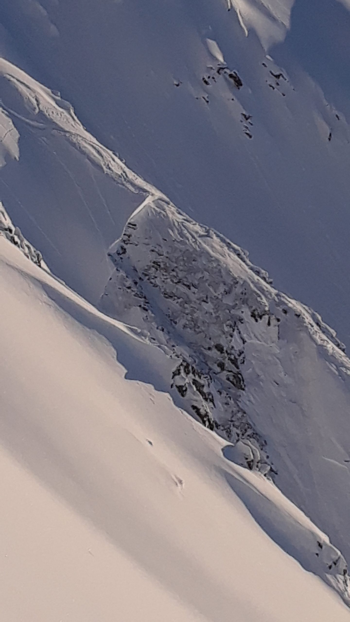
Tincan. This avalanche occurred almost two weeks ago, but similar avalanches are still a concern for now. Photo: Matthew Howard. 12.04.2020

As always, use safe travel protocol to minimize your risk while you are out. Be on the lookout for clear signs of unstable snow like shooting cracks or whumpfs, only expose one person at a time to avalanche terrain (including runout zones), and keep an eye on your partners from a safe spot if you do choose to ski or snowmachine in steep terrain. You will also want to be aware of lingering wind slabs from the past few days, and continue to give cornices plenty of space. The mountains closer to Girdwood have received 6-8” of low-density snow since Monday morning, and although that will not be enough to bump up the avalanche danger, it may be enough snow to create loose dry avalanches that could knock you off your feet.

Weather
Wed, December 16th, 2020

Yesterday: Yesterday brought 4” new snow to Alyeska and 1-2” at Turnagain pass, with winds staying around 5 mph or lower. Temperatures reached into the mid- to upper 20’s F with lows in the high teens at upper elevations and the low 30’s F with lows in the mid- to upper 20’s F at lower elevations.

Today: Mountain temperatures are expected to drop throughout the day, reaching the high teens F by this afternoon at upper elevations and staying in the mid 20’s F at lower elevations. Low temperatures tonight will be around 10 F at upper elevations and 20 F in the valleys. Skies will be partly cloudy, with clouds clearing throughout the day. We are expecting light westerly winds around 5-10 mph, with little or no precipitation.

Tomorrow: We have a chance of light snow tomorrow, with 1-4” possible in the mountains. Temperatures should stay cold enough to keep snow at sea level. Easterly winds are expected to pick up slightly to 10-15 mph, with high temperatures around 20 F at upper elevations and 30 F at low elevations.

PRECIPITATION 24-hour data (6am – 6am)

Temp Avg (F) Snow (in) Water (in) Snow Depth (in)
Center Ridge (1880′) 26 1 0.1 59
Summit Lake (1400′) 26 1 0.1 25
Alyeska Mid (1700′) 26 2* 0.2* 62*

*Last update at 1:00 a.m.

RIDGETOP 24-hour data (6am – 6am)

Temp Avg (F) Wind Dir Wind Avg (mph) Wind Gust (mph)
Sunburst (3812′) 20 VAR 1 6
Seattle Ridge (2400′) 23 0
Observations
Recent Observations for Turnagain Pass
Date Region Location
05/22/23 Turnagain Avalanche: Tincan
05/12/23 Turnagain Avalanche: Tincan, Sunburst, Magnum, Cornbiscuit
05/07/23 Turnagain Observation: Tincan – Bear Tracks
05/05/23 Turnagain Observation: Seattle Ridge
05/02/23 Turnagain Observation: Cornbiscuit
05/02/23 Turnagain Observation: Seward Hwy Turnagain Pass
04/30/23 Turnagain Observation: Magnum
04/29/23 Turnagain Observation: Tincan
04/28/23 Turnagain Avalanche: Taylor Pass/Pastoral
04/28/23 Turnagain Avalanche: Tincan
Riding Areas
Updated Mon, May 15th, 2023

Status of riding areas across the Chugach NF is managed by the Glacier and Seward Ranger Districts, not avalanche center staff. Riding area information is posted as a public service to our users and updated based on snow depth and snow density to prevent resource damage at trailhead locations. Riding area questions contact: mailroom_r10_chugach@fs.fed.us

Area Status Weather & Riding Conditions
Glacier District
Johnson Pass
Closed
Closed May 15.
Placer River
Closed
Closed May 15.
Skookum Drainage
Closed
Will close to motorized use on April 1, 2023 per the National Forest Plan.
Turnagain Pass
Open
Chugach NF staff will be assessing daily after May 15th. Please keep machines on the snow and avoid brown spots to keep this area open as long as possible.
Twentymile
Closed
Scheduled closure May 1.
Seward District
Carter Lake
Closed
Scheduled closure May 1.
Lost Lake Trail
Closed
Scheduled closure May 1.
Primrose Trail
Closed
Scheduled closure May 1.
Resurrection Pass Trail
Closed
Closed to motorized use for the 2022/23 winter season per Forest Plan. Open next season.
Snug Harbor
Closed
Extended opening until May 15.
South Fork Snow River Corridor
Closed
Scheduled closure May 1.
Summit Lake
Closed
Scheduled closure May 1.

Subscribe to Turnagain Pass
Avalanche Forecast by Email

This is a general backcountry avalanche advisory issued for Turnagain Arm with Turnagain Pass as the core advisory area. This advisory does not apply to highways, railroads or operating ski areas.