Turnagain Pass Avalanche Forecast RSS

Archives
ARCHIVED FORECAST - All forecasts expire after 24 hours from the posting date/time.
Issued
Fri, December 13th, 2019 - 7:00AM
Expires
Sat, December 14th, 2019 - 7:00AM
Forecaster
Wendy Wagner
Avalanche risk The Bottom Line

The avalanche danger is CONSIDERABLE above 1,000′ for a variety of avalanche problems. At the mid-elevations, glide cracks are opening and releasing into avalanches currently. Avoid being under any crack forming in the snowpack as these are very unpredictable avalanches. At the high elevations, new snow and strong wind are keeping the potential for wind slab avalanches and cornice falls to occur naturally as well as be easily triggered by a person.

Thanks to our sponsors!
Fri, December 13th, 2019
Alpine
Above 2,500'
Considerable (3)
Avalanche risk
Treeline
1,000'-2,500'
Considerable (3)
Avalanche risk
Below Treeline
Below 1,000'
No Rating (0)
Avalanche risk
Alpine
Above 2,500'
Avalanche risk
Considerable (3)
Treeline
1,000'-2,500'
Avalanche risk
Considerable (3)
Below Treeline
Below 1,000'
Avalanche risk
No Rating (0)
Danger Scale:
No Rating (0)
Low (1)
Moderate (2)
Considerable (3)
High (4)
Extreme (5)
Recent Avalanches

Although it has been raining down in town and into the mid-elevations up to 2,500′, the higher elevation snowpack is growing. Around 5-8″ of new snow has fallen overnight in favored areas with up to another 5″ of snow expected through today. On top of this, there is 5 – 7″ forecast for tonight. The good news is, the rain/snow line looks to lower this evening to around 1,500′ and should hover in this zone through the weekend. With limited visibility and information in the snowy regions, there is much uncertainty as to recent avalanche activity at these high elevations. What we do know however, is many mid-elevations slopes are seeing glide avalanche activity.

Several glide avalanches released yesterday in the Girdwood Valley due to the warm weather and precipitation. There are also now a few cracks opening up on mid-elevation terrain at Turnagain as well, specifically on Tincan as seen in the photo below.

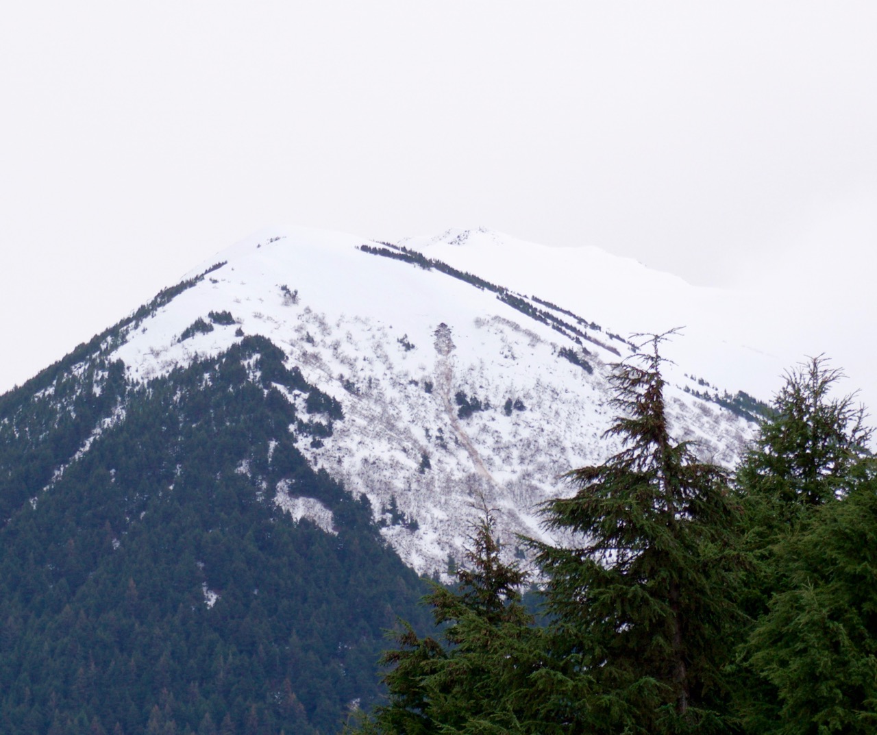
Glide avalanche that released yesterday. This is on Orca mtn, which sits in the Girdwood Vally just east of the Tesoro gas station.


Cracks opening up in the Tincan Trees, viewed from the RWIS webcam at Turnagain Pass

Avalanche Problem 1
  • Glide Avalanches
    Glide Avalanches
  • Almost Certain
    Very Likely
    Likely
    Possible
    Unlikely
    Likelihood
  • Historic (D4-5)
    Very Large (D3)
    Large (D2)
    Small (D1)
    Size
Glide Avalanches
Glide Avalanches are the release of the entire snow cover as a result of gliding over the ground. Glide avalanches can be composed of wet, moist, or almost entirely dry snow. They typically occur in very specific paths, where the slope is steep enough and the ground surface is relatively smooth. They are often proceeded by full depth cracks (glide cracks), though the time between the appearance of a crack and an avalanche can vary between seconds and months. Glide avalanches are unlikely to be triggered by a person, are nearly impossible to forecast, and thus pose a hazard that is extremely difficult to manage.

Likelihood of Avalanches
Terms such as "unlikely", "likely", and "certain" are used to define the scale, with the chance of triggering or observing avalanches increasing as we move up the scale. For our purposes, "Unlikely" means that few avalanches could be triggered in avalanche terrain and natural avalanches are not expected. "Certain" means that humans will be able to trigger avalanches on many slopes, and natural avalanches are expected.

Size of Avalanches
Avalanche size is defined by the largest potential avalanche, or expected range of sizes related to the problem in question. Assigned size is a qualitative estimate based on the destructive classification system and requires specialists to estimate the harm avalanches may cause to hypothetical objects located in the avalanche track (AAA 2016, CAA 2014). Under this schema, "Small" avalanches are not large enough to bury humans and are relatively harmless unless they carry people over cliffs or through trees or rocks. Moving up the scale, avalanches become "Large" enough to bury, injure, or kill people. "Very Large" avalanches may bury or destroy vehicles or houses, and "Historic" avalanches are massive events capable of altering the landscape.

Signal Word Size (D scale) Simple Descriptor
Small 1 Unlikely to bury a person
Large 2 Can bury a person
Very Large 3 Can destroy a house
Historic 4 & 5 Can destroy part or all of a village
More info at Avalanche.org

Glide avalanches are expected to continue to release today. Many cracks have opened up through the region. New cracks likely formed overnight. The only way to manage this problem is to avoid or limit time under cracks. There is no way of knowing when a crack might release and these are not triggered by people.

Avalanche Problem 2
  • Wind Slabs
    Wind Slabs
  • Almost Certain
    Very Likely
    Likely
    Possible
    Unlikely
    Likelihood
  • Historic (D4-5)
    Very Large (D3)
    Large (D2)
    Small (D1)
    Size
Wind Slabs
Wind Slab avalanches are the release of a cohesive layer of snow (a slab) formed by the wind. Wind typically transports snow from the upwind sides of terrain features and deposits snow on the downwind side. Wind slabs are often smooth and rounded and sometimes sound hollow, and can range from soft to hard. Wind slabs that form over a persistent weak layer (surface hoar, depth hoar, or near-surface facets) may be termed Persistent Slabs or may develop into Persistent Slabs.

Likelihood of Avalanches
Terms such as "unlikely", "likely", and "certain" are used to define the scale, with the chance of triggering or observing avalanches increasing as we move up the scale. For our purposes, "Unlikely" means that few avalanches could be triggered in avalanche terrain and natural avalanches are not expected. "Certain" means that humans will be able to trigger avalanches on many slopes, and natural avalanches are expected.

Size of Avalanches
Avalanche size is defined by the largest potential avalanche, or expected range of sizes related to the problem in question. Assigned size is a qualitative estimate based on the destructive classification system and requires specialists to estimate the harm avalanches may cause to hypothetical objects located in the avalanche track (AAA 2016, CAA 2014). Under this schema, "Small" avalanches are not large enough to bury humans and are relatively harmless unless they carry people over cliffs or through trees or rocks. Moving up the scale, avalanches become "Large" enough to bury, injure, or kill people. "Very Large" avalanches may bury or destroy vehicles or houses, and "Historic" avalanches are massive events capable of altering the landscape.

Signal Word Size (D scale) Simple Descriptor
Small 1 Unlikely to bury a person
Large 2 Can bury a person
Very Large 3 Can destroy a house
Historic 4 & 5 Can destroy part or all of a village
More info at Avalanche.org

Ridgetop easterly winds are not slowing down. They have been continuously blowing in the 20-35 mph range for two days now and are forecast to increase up to the 40’s mph today. That said, wind slab avalanches and cornice falls are expected to remain the concern on high elevation slopes. These may release naturally or be easily triggered by a person. Poor visibility will likely hamper travel to these zones, but if you do find yourself there, look for how the wind has been reshaping and depositing the snow. Avoiding any wind loaded slope or cross-loaded gully will be key. Watch for stiffer snow over softer snow, hollow feeling snow and any cracking in the snow around you, these are ways to identify a wind slab.

Storm slab avalanches – there could be slopes that accumulate up to a foot or more of new snow by this afternoon. In these areas, storm slab avalanches will be possible to trigger in areas out of the wind.

Additional Concern
  • Persistent Slabs
    Persistent Slabs
Persistent Slabs
Persistent Slab avalanches are the release of a cohesive layer of snow (a slab) in the middle to upper snowpack, when the bond to an underlying persistent weak layer breaks. Persistent layers include: surface hoar, depth hoar, near-surface facets, or faceted snow. Persistent weak layers can continue to produce avalanches for days, weeks or even months, making them especially dangerous and tricky. As additional snow and wind events build a thicker slab on top of the persistent weak layer, this avalanche problem may develop into a Deep Persistent Slab.
More info at Avalanche.org

Deeper in the snowpack at the upper elevations we are tracking layers of weak faceted snow from November. How these layers have adjusted over the past week of stormy weather and increasing snow load is something we are watching. Turnagain Pass had a layer of facets over a hard crust near the ground and the Summit Lake zone had several facet/crust combinations composing the snowpack.

Weather
Fri, December 13th, 2019

Yesterday:  Cloudy skies with light rainfall in the afternoon and overnight adding ~.5-.8″ of water below 2,500′ and roughly 5-8″ of snow above this. Ridgetop winds have continued to blow in the 20-30mph range with gusts into the 60’s mph from an easterly direction. Temperatures have cooled slightly overnight and sit near 40F at sea level and the mid 20’s F along the ridgelines.

Today:  Rainy weather at elevations below 2,500′ will continue through the day, adding around half an inch of water (estimated 5″ of new snow in the Alpine). Tonight, another 3/4″ of water is expected with a lowering rain/snow line to near 1,500′ (estimated 6-8″ additional snow in the Alpine). Ridgetop winds will remain strong from the east, 30-45mph range with stronger gusts.

Tomorrow:  The unsettled weather pattern will continue through the weekend bringing more wind and precipitation. The good news is temperatures seem to be on a cooling trend according to the models. The rain/snow looks to hover between 1,000′ and 2,000′ for the next couple days.

PRECIPITATION 24-hour data (6am – 6am)

Temp Avg (F) Snow (in) Water (in) Snow Depth (in)
Center Ridge (1880′) 36 0 0.7 17
Summit Lake (1400′) 36 0 0.1 7
Alyeska Mid (1700′) 36 0 0.8 14

RIDGETOP 24-hour data (6am – 6am)

Temp Avg (F) Wind Dir Wind Avg (mph) Wind Gust (mph)
Sunburst (3812′) 28 NE 21 64
Seattle Ridge (2400′) N/A* N/A* N/A* N/A*

*Seattle Ridge weather station is down and as soon as the weather clears we will get it up and running!

Observations
Recent Observations for Turnagain Pass
Date Region Location
05/22/23 Turnagain Avalanche: Tincan
05/12/23 Turnagain Avalanche: Tincan, Sunburst, Magnum, Cornbiscuit
05/07/23 Turnagain Observation: Tincan – Bear Tracks
05/05/23 Turnagain Observation: Seattle Ridge
05/02/23 Turnagain Observation: Cornbiscuit
05/02/23 Turnagain Observation: Seward Hwy Turnagain Pass
04/30/23 Turnagain Observation: Magnum
04/29/23 Turnagain Observation: Tincan
04/28/23 Turnagain Avalanche: Taylor Pass/Pastoral
04/28/23 Turnagain Avalanche: Tincan
Riding Areas
Updated Thu, June 01st, 2023

Status of riding areas across the Chugach NF is managed by the Glacier and Seward Ranger Districts, not avalanche center staff. Riding area information is posted as a public service to our users and updated based on snow depth and snow density to prevent resource damage at trailhead locations. Riding area questions contact: mailroom_r10_chugach@fs.fed.us

Area Status Weather & Riding Conditions
Glacier District
Johnson Pass
Closed
Closed May 15.
Placer River
Closed
Closed May 15.
Skookum Drainage
Closed
Will close to motorized use on April 1, 2023 per the National Forest Plan.
Turnagain Pass
Closed
Will close on June 1.
Twentymile
Closed
Scheduled closure May 1.
Seward District
Carter Lake
Closed
Scheduled closure May 1.
Lost Lake Trail
Closed
Scheduled closure May 1.
Primrose Trail
Closed
Scheduled closure May 1.
Resurrection Pass Trail
Closed
Closed to motorized use for the 2022/23 winter season per Forest Plan. Open next season.
Snug Harbor
Closed
Extended opening until May 15.
South Fork Snow River Corridor
Closed
Scheduled closure May 1.
Summit Lake
Closed
Scheduled closure May 1.

Subscribe to Turnagain Pass
Avalanche Forecast by Email

This is a general backcountry avalanche advisory issued for Turnagain Arm with Turnagain Pass as the core advisory area. This advisory does not apply to highways, railroads or operating ski areas.