Turnagain Pass RSS

Archives
ARCHIVED - Forecasts expire after 24 hours.
Issued
Sat, December 11th, 2021 - 7:00AM
Expires
Sun, December 12th, 2021 - 7:00AM
Forecaster
John Sykes
Avalanche risk The Bottom Line

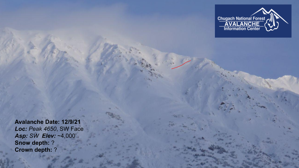
The avalanche danger is CONSIDERABLE at all elevations today. Human triggered avalanches 1-3′ deep are likely especially in wind loaded areas. Winds during the last storm were out of the east but are currently blowing out of the northwest, so wind slabs could exist on a variety of aspects. Very large and destructive avalanches in a layer of weak sugary snow buried 3-6′ deep are also likely and could be triggered by a person or a smaller avalanche. These avalanches have the potential to be triggered remotely (from above, below, or to the sides of steeper terrain) and could release much wider than expected. Conservative terrain selection and being aware of steeper slopes above you is essential to manage these dangerous avalanche conditions.

Summit Lake: Despite not getting much new snow during the last storm a recent human triggered avalanche on a layer of buried facets indicates that the potential still exists for triggering avalanches on older buried weak layers. Summit area could see stronger winds today that may build new wind slabs.

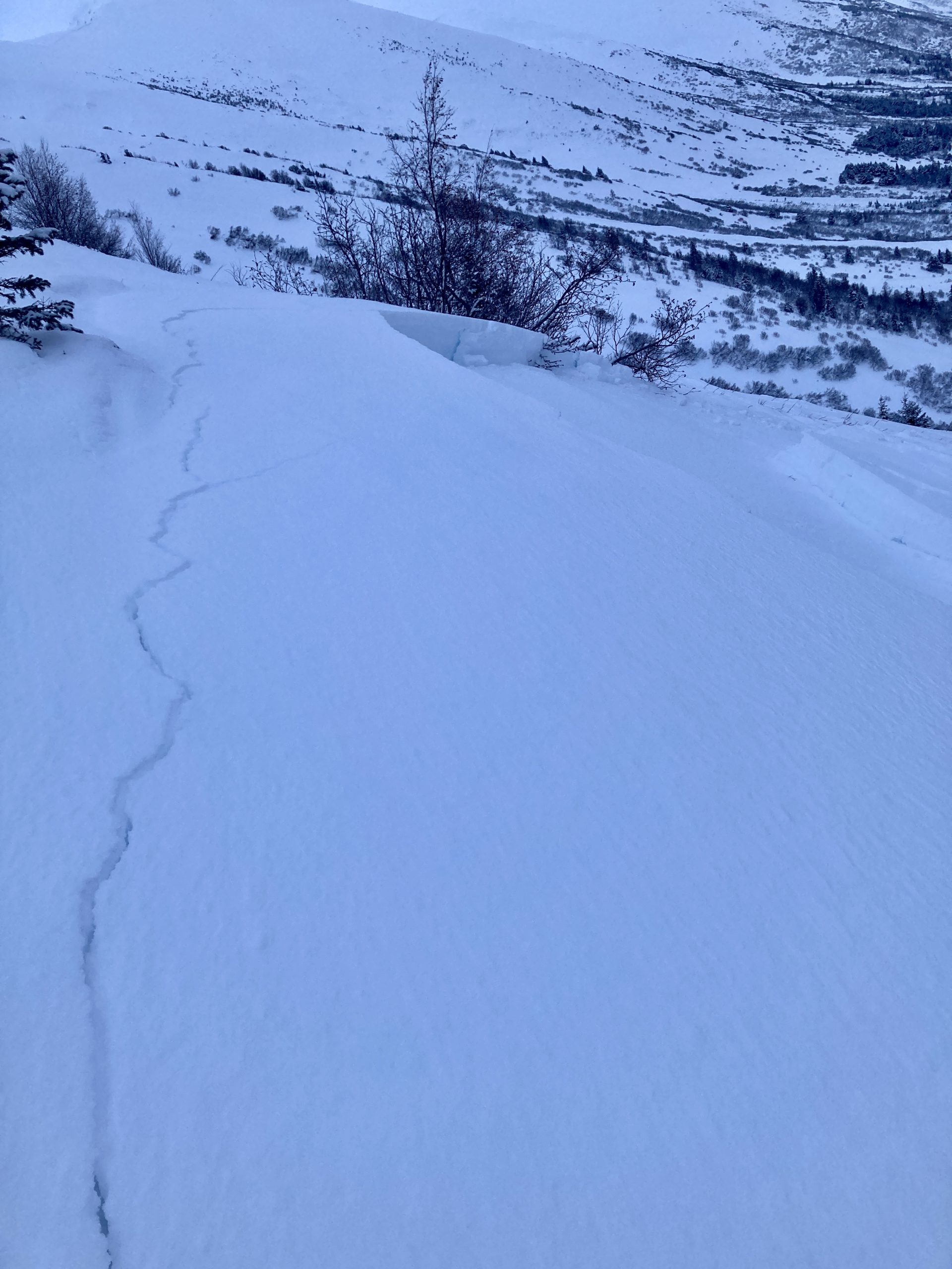
Seward/Snug Harbor: We received a report of frequent collapsing/whumphing and a small remote triggered avalanche in Seward yesterday (see recent avalanches). In areas that received strong winds and have a weak existing snowpack human triggered avalanches are very likely today. These could be 1 to 3′ deep in the most recent storm snow or release on buried weak layers 3 to 6′ deep resulting in very large and destructive avalanches.

Sat, December 11th, 2021
Alpine
Above 2,500'
3 - Considerable
Avalanche risk
Treeline
1,000'-2,500'
3 - Considerable
Avalanche risk
Below Treeline
Below 1,000'
3 - Considerable
Avalanche risk
0 - No Rating
1 - Low
2 - Moderate
3 - Considerable
4 - High
5 - Extreme
Avalanche risk Avalanche risk Avalanche risk Avalanche risk Avalanche risk
Travel Advice Generally safe avalanche conditions. Watch for unstable snow on isolated terrain features. Heightened avalanche conditions on specific terrain features. Evaluate snow and terrain carefully; identify features of concern. Dangerous avalanche conditions. Careful snowpack evaluation, cautious route-finding, and conservative decision-making essential. Very dangerous avalanche conditions. Travel in avalanche terrain not recommended. Extraordinarily dangerous avalanche conditions. Avoid all avalanche terrain.
Likelihood of Avalanches Natural and human-triggered avalanches unlikely. Natural avalanches unlikely; human-triggered avalanches possible. Natural avalanches possible; human-triggered avalanches likely. Natural avalanches likely; human-triggered avalanches very likely. Natural and human-triggered avalanches certain.
Avalanche Size and Distribution Small avalanches in isolated areas or extreme terrain. Small avalanches in specific areas; or large avalanches in isolated areas. Small avalanches in many areas; or large avalanches in specific areas; or very large avalanches in isolated areas. Large avalanches in many areas; or very large avalanches in specific areas. Very large avalanches in many areas.
Recent Avalanches
  • Turnagain Pass: Magnum, N face – Crown from either 12.9 or 12.10.21 at ~2900′ on N aspect, observed from center ridge lot. Could be an old glide crack, but appears more likely to be a new avalanche that was partially filled in by wind blown snow. Appears to have broken into deeper faceted layer, but really difficult to tell with combination of cloud cover and only seeing it from a long distance away.

Photo 12.10.21

  • Turnagain Pass: Cornbiscuit N face – From either 12.9 or 12.10.21 on N aspect at ~2,700′. Another potential new crown seen from a long ways away during a short break in cloud cover. Appears to be similar terrain character, aspect, elevation, and depth as release on Magnum.

Photo 12.10.21

  • Turnagain Pass: About a mile NW of Peak 4940 along ridgeline (labelled 4650 on Cal Topo map) – From either 12.9 or 12.10.21 on SW aspect at ~4000′. Likely a release in the new snow or a wind loaded pocket of new snow.

Photo 12.10.21

  • Summit Lake: Fresno Ridge – Small human triggered avalanche at 2000′ on SSW aspect along Fresno ridge in Summit Lake area.

Small human triggered avalanche in Summit Lake area. Photo Mr. Savoona 12.10.21

  • Seward: We received a report of a small human triggered wind slab that released remotely on Mt Alice. The group also reported lots of collapsing and whumphing along their route and strong winds transporting snow.
Avalanche Problem 1
  • Wind Slabs
    Wind Slabs
  • Certain
    Very Likely
    Likely
    Possible
    Unlikely
    Likelihood
  • Historic (D4-5)
    Very Large (D3)
    Large (D2)
    Small (D1)
    Size
Wind Slabs
Wind Slab avalanches are the release of a cohesive layer of snow (a slab) formed by the wind. Wind typically transports snow from the upwind sides of terrain features and deposits snow on the downwind side. Wind slabs are often smooth and rounded and sometimes sound hollow, and can range from soft to hard. Wind slabs that form over a persistent weak layer (surface hoar, depth hoar, or near-surface facets) may be termed Persistent Slabs or may develop into Persistent Slabs.

Likelihood of Avalanches
Terms such as "unlikely", "likely", and "certain" are used to define the scale, with the chance of triggering or observing avalanches increasing as we move up the scale. For our purposes, "Unlikely" means that few avalanches could be triggered in avalanche terrain and natural avalanches are not expected. "Certain" means that humans will be able to trigger avalanches on many slopes, and natural avalanches are expected.

Size of Avalanches
Avalanche size is defined by the largest potential avalanche, or expected range of sizes related to the problem in question. Assigned size is a qualitative estimate based on the destructive classification system and requires specialists to estimate the harm avalanches may cause to hypothetical objects located in the avalanche track (AAA 2016, CAA 2014). Under this schema, "Small" avalanches are not large enough to bury humans and are relatively harmless unless they carry people over cliffs or through trees or rocks. Moving up the scale, avalanches become "Large" enough to bury, injure, or kill people. "Very Large" avalanches may bury or destroy vehicles or houses, and "Historic" avalanches are massive events capable of altering the landscape.

Signal Word Size (D scale) Simple Descriptor
Small 1 Unlikely to bury a person
Large 2 Can bury a person
Very Large 3 Can destroy a house
Historic 4 & 5 Can destroy part or all of a village
More info at Avalanche.org

As the skies start to clear today it may be tempting to venture into more consequential avalanche terrain, but with moderate winds from 10-25 mph and lots of light snow available for transport we expect wind slabs to be sensitive to human triggering anywhere from 1 to 3′ deep. We are entering another period of outflow winds from a cold airmass in the interior, and during our last weather pattern like this the Seattle Creek drainage saw higher winds than the rest of Turnagain Pass. In addition we are still very concerned about the potential for triggering very large avalanches 3 to 6′ deep on a layer of buried facets (see problem 2 for more details). Conservative decision-making and terrain selection is essential today, keeping slope angles low and being aware of potential active wind loading along ridgelines.

During the last storm (Thursday through Friday morning) 12 to 24″ of snow fell with wind speeds from 20-35 mph out of the east. We saw evidence of wind transport during a brief break in the clouds yesterday that indicates wind slabs are likely to be lingering along ridelines and in cross loaded gullies. Today the winds are forecast to blow out of the northwest and could create new wind slabs in different terrain features compared to the winds during the storm. Look for fresh cornices, texture on the surface of the snow, hollow feeling snow, and smooth pillow features to identify areas with wind slabs.

Wind affected snow along the ridgeline of Cornbiscuit yesterday. Photo 12.10.21

Avalanche Problem 2
  • Persistent Slabs
    Persistent Slabs
  • Certain
    Very Likely
    Likely
    Possible
    Unlikely
    Likelihood
  • Historic (D4-5)
    Very Large (D3)
    Large (D2)
    Small (D1)
    Size
Persistent Slabs
Persistent Slab avalanches are the release of a cohesive layer of snow (a slab) in the middle to upper snowpack, when the bond to an underlying persistent weak layer breaks. Persistent layers include: surface hoar, depth hoar, near-surface facets, or faceted snow. Persistent weak layers can continue to produce avalanches for days, weeks or even months, making them especially dangerous and tricky. As additional snow and wind events build a thicker slab on top of the persistent weak layer, this avalanche problem may develop into a Deep Persistent Slab.

Likelihood of Avalanches
Terms such as "unlikely", "likely", and "certain" are used to define the scale, with the chance of triggering or observing avalanches increasing as we move up the scale. For our purposes, "Unlikely" means that few avalanches could be triggered in avalanche terrain and natural avalanches are not expected. "Certain" means that humans will be able to trigger avalanches on many slopes, and natural avalanches are expected.

Size of Avalanches
Avalanche size is defined by the largest potential avalanche, or expected range of sizes related to the problem in question. Assigned size is a qualitative estimate based on the destructive classification system and requires specialists to estimate the harm avalanches may cause to hypothetical objects located in the avalanche track (AAA 2016, CAA 2014). Under this schema, "Small" avalanches are not large enough to bury humans and are relatively harmless unless they carry people over cliffs or through trees or rocks. Moving up the scale, avalanches become "Large" enough to bury, injure, or kill people. "Very Large" avalanches may bury or destroy vehicles or houses, and "Historic" avalanches are massive events capable of altering the landscape.

Signal Word Size (D scale) Simple Descriptor
Small 1 Unlikely to bury a person
Large 2 Can bury a person
Very Large 3 Can destroy a house
Historic 4 & 5 Can destroy part or all of a village
More info at Avalanche.org

Human triggered avalanches on a layer of facets buried 3 to 6′ deep are still likely today and would result in very large and destructive avalanches. This layer has been the culprit of many near misses in the past week and has shown the potential for remote triggering and very wide propagation. We heard reports of collapsing and whumphing across the region yesterday which indicate that this buried weak layer is still reactive. During a brief break in the cloud cover we saw a few potential new avalanches on this layer at about 2800′ on the north faces of Magnum and Cornbiscuit. The only way to manage this type of avalanche problem is through conservative terrain selection and avoiding areas underneath steep slopes.

Snowpack structure for faceted weak layer. All the snow from the past several weeks acting as a slab on top of a thick layer of sugary facets on top of a firm bed surface. Photo 12.8.21


Weather
Sat, December 11th, 2021

Yesterday: The latest round of snowfall stopped by 9am with no additional accumulation throughout the day. Winds were light at 5-10 mph out of the NW with gusts into the 20’s in the morning. Cloud cover remained in the northern portion of Turnagain Pass throughout the day but broke up in the southern portion of the pass in the afternoon. Temperatures stayed in the teens through the day but dropped into the single digits overnight.

Today: Temperatures should remain in the single digits and trend towards negative single digits this afternoon. Winds will remain predominantly out of the northwest but increase to moderate wind speed in the range of 10-25 mph. Cloud cover should diminish throughout the day today.

Tomorrow: Cold temperatures and moderate winds out of the northwest look to be the norm for Sunday and Monday as well, with lows potentially dropping into the negative teens. On Monday night the winds look to shift to the southeast and temperatures should warm up a bit.

PRECIPITATION 24-hour data (6am – 6am)

Temp Avg (F) Snow (in) Water (in) Snow Depth (in)
Center Ridge (1880′) 20 0 0 84
Summit Lake (1400′) 17 0 0 26
Alyeska Mid (1700′) 16 0 0 53

RIDGETOP 24-hour data (6am – 6am)

Temp Avg (F) Wind Dir Wind Avg (mph) Wind Gust (mph)
Sunburst (3812′) 8 NW 7 24
Seattle Ridge (2400′) 13 NA NA NA

*Seattle Ridge weather station is rimed and not reading wind speed or direction currently.

Observations
Recent Observations for Turnagain Pass
Date Region Location
04/16/24 Turnagain Observation: Cornbiscuit
04/15/24 Turnagain Observation: Taylor Pass
04/15/24 Turnagain Observation: Seward Highway – Tern Lake to Portage
04/14/24 Turnagain Observation: Sunburst
04/14/24 Turnagain Observation: Turnagain Pass Snomo
04/13/24 Turnagain Observation: Spokane Creek
04/11/24 Turnagain Observation: Tincan
04/10/24 Turnagain Avalanche: Seattle Ridge
04/10/24 Turnagain Observation: Cornbiscuit South Face
04/10/24 Turnagain Avalanche: Tincan
Riding Areas

The riding areas page has moved. Please click here & update your bookmarks.


Subscribe to Turnagain Pass
Avalanche Forecast by Email

This is a general backcountry avalanche advisory issued for Turnagain Arm with Turnagain Pass as the core advisory area. This advisory does not apply to highways, railroads or operating ski areas.