Today’s avalanche danger is CONSIDERABLE at all elevations. Steady snowfall for the past two days with rain up to 1200′, along with sustained periods of strong winds, have created dangerous avalanche conditions. Human triggered avalanches are likely today, and natural avalanches are possible with fresh storm and wind slabs sitting on weak snow. Be conservative with your terrain use today by avoiding travelling on or directly below steep slopes.
SUMMIT LAKE: The snowpack in the Summit Lake area is generally thinner and weaker, making it easier to trigger a deep slab avalanche near the ground. This issue is particularly concerning in the Alpine. Be extra cautious with your terrain choices, and avoid steep, rocky terrain where these avalanches will be most likely.
Tue, December 8th, 2020
Alpine
Above 2,500'
3 - Considerable
Treeline
1,000'-2,500'
3 - Considerable
Below Treeline
Below 1,000'
3 - Considerable
0 - No Rating
1 - Low
2 - Moderate
3 - Considerable
4 - High
5 - Extreme
Travel Advice
Generally safe avalanche conditions. Watch for unstable snow on isolated terrain features.
Heightened avalanche conditions on specific terrain features. Evaluate snow and terrain carefully; identify features of concern.
Natural avalanches likely; human-triggered avalanches very likely.
Natural and human-triggered avalanches certain.
Avalanche Size and Distribution
Small avalanches in isolated areas or extreme terrain.
Small avalanches in specific areas; or large avalanches in isolated areas.
Small avalanches in many areas; or large avalanches in specific areas; or very large avalanches in isolated areas.
Large avalanches in many areas; or very large avalanches in specific areas.
Very large avalanches in many areas.
Avalanche Problem 1
Storm Slabs
Certain
Very Likely
Likely
Possible
Unlikely
Likelihood
Historic (D4-5)
Very Large (D3)
Large (D2)
Small (D1)
Size
Storm Slabs
Storm Slab avalanches are the release of a cohesive layer (a slab) of new snow that breaks within new snow or on the old snow surface. Storm-slabs typically last between a few hours and few days (following snowfall). Storm-slabs that form over a persistent weak layer (surface hoar, depth hoar, or near-surface facets) may be termed Persistent Slabs or may develop into Persistent Slabs.
Likelihood of Avalanches
Terms such as "unlikely", "likely", and "certain" are used to define the scale, with the chance of triggering or observing
avalanches increasing as we move up the scale. For our purposes, "Unlikely" means that few avalanches could be triggered in avalanche terrain and
natural avalanches are not expected. "Certain" means that humans will be able to trigger avalanches on many slopes, and natural avalanches are expected.
Size of Avalanches
Avalanche size is defined by the largest potential avalanche, or expected range of sizes related to the problem in question.
Assigned size is a qualitative estimate based on the destructive classification system and requires specialists to estimate the harm avalanches may cause to
hypothetical objects located in the avalanche track (AAA 2016, CAA 2014). Under this schema, "Small" avalanches are not large enough to bury humans and are
relatively harmless unless they carry people over cliffs or through trees or rocks. Moving up the scale, avalanches become "Large" enough to bury, injure,
or kill people. "Very Large" avalanches may bury or destroy vehicles or houses, and "Historic" avalanches are massive events capable of altering the landscape.
Today it is likely a human could trigger an avalanche 2-4’ deep, failing at the weak interface between this new snow and the old snow surface. The mountains have received steady precipitation since early Sunday morning, and storm totals are approaching 2-3’ in the alpine with the highest totals near Girdwood. The rain line crept up to 1200′ by yesterday afternoon. Here is the storm tally since Sunday, as of 5 a.m. this morning:
Turnagain Pass at 1,880′: 1.7” of water equivalent, roughly 18-24” of snow above treeline.
Girdwood Valley at 1,700′: 2.6″ of water equivalent, roughly 2-3′ of snow above treeline.
Portage Valley at sea level: 2.6″ of water equivalent, roughly 2-3′ of snow above treeline.
Summit Lake at 1,400′: .3″ of water equivalent, roughly 4-6″ of snow above treeline.
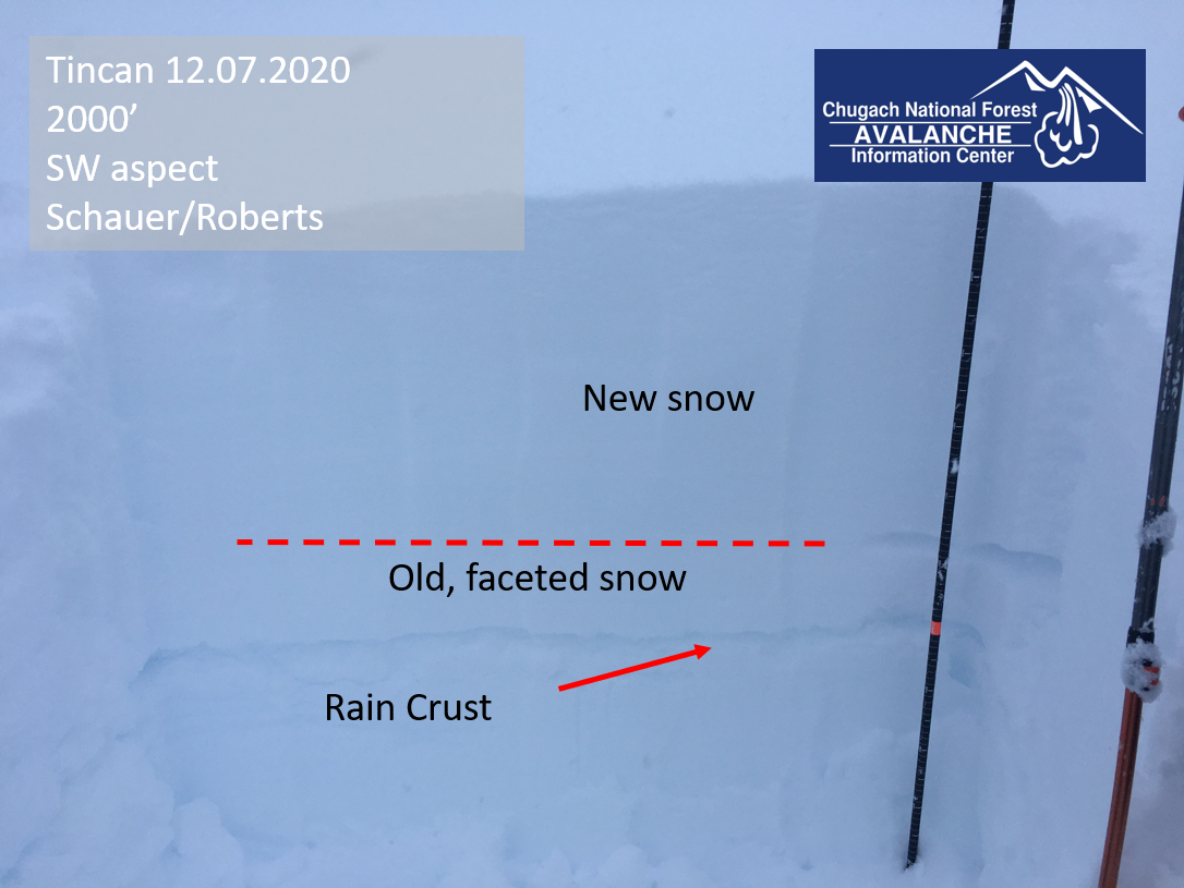
This snow has fallen on a weak layer of faceted snow, which rests on a stout rain crust at elevations below 2500 feet. Ridgetop winds were blowing 20-35 mph yesterday, including an eight-hour window where wind speeds stayed above 30 mph with gusts at or above 50 mph. We saw a plethora of red flags in the Tincan area, including shooting cracks, multiple collapses, and unstable test results. Even as the snow tapers off during the day, avalanche conditions will remain dangerous. Although it may be tempting to push into bigger terrain as we see a lull in the storm during the day, conservative decision making will be the key to avoiding a serious accident. It will be important to avoid slopes steeper than 30 degrees, as well as the runout zones below steep terrain.
Cornices: With plenty of new snow and extend periods of strong winds, cornices are growing quickly and will be an additional concern today. Be sure to give them plenty of space, as they often extend farther back than you would think.
Tincan. Snowpit at 2000′, with 15″ of new snow sitting on facets, sitting on a crust. 12.07.2020
Avalanche Problem 2
Deep Persistent Slabs
Certain
Very Likely
Likely
Possible
Unlikely
Likelihood
Historic (D4-5)
Very Large (D3)
Large (D2)
Small (D1)
Size
Deep Persistent Slabs
Deep Persistent Slab avalanches are the release of a thick cohesive layer of hard snow (a slab), when the bond breaks between the slab and an underlying persistent weak layer deep in the snowpack. The most common persistent weak layers involved in deep, persistent slabs are depth hoar or facets surrounding a deeply buried crust. Deep Persistent Slabs are typically hard to trigger, are very destructive and dangerous due to the large mass of snow involved, and can persist for months once developed. They are often triggered from areas where the snow is shallow and weak, and are particularly difficult to forecast for and manage.
Likelihood of Avalanches
Terms such as "unlikely", "likely", and "certain" are used to define the scale, with the chance of triggering or observing
avalanches increasing as we move up the scale. For our purposes, "Unlikely" means that few avalanches could be triggered in avalanche terrain and
natural avalanches are not expected. "Certain" means that humans will be able to trigger avalanches on many slopes, and natural avalanches are expected.
Size of Avalanches
Avalanche size is defined by the largest potential avalanche, or expected range of sizes related to the problem in question.
Assigned size is a qualitative estimate based on the destructive classification system and requires specialists to estimate the harm avalanches may cause to
hypothetical objects located in the avalanche track (AAA 2016, CAA 2014). Under this schema, "Small" avalanches are not large enough to bury humans and are
relatively harmless unless they carry people over cliffs or through trees or rocks. Moving up the scale, avalanches become "Large" enough to bury, injure,
or kill people. "Very Large" avalanches may bury or destroy vehicles or houses, and "Historic" avalanches are massive events capable of altering the landscape.
The weak snow at the base of the snowpack continues to be a concern, and 1.5-3” snow water equivalent over the past two days is pushing the needle towards instability. This layer is especially concerning in areas with a thinner snowpack. In the past week, we have seen avalanches fail at or near the ground, and this will be a concern today. The most likely place to trigger a deep persistent slab avalanche is where the snowpack is thinner. This can be a slope that has been scoured by the wind at some point this season, or in steep, rocky slopes, or in areas with lower total snowfall. As our snowpack gets deeper, these avalanches are becoming less likely, but they can be very large if triggered. A falling cornice or an avalanche failing in the new snow at the surface will apply a huge load very quickly, making a dangerous trigger for a large deep slab avalanche. If the storm slab problem hasn’t given enough reason to avoid steep terrain today, these avalanches absolutely should.
Weather
Tue, December 8th, 2020
Yesterday: Yesterday’s snow came in a little stronger than anticipated, with 1.3″ of water at 1700′ in Girdwood, and 0.8″ water at 1880′ at Turnagain. The rain line rose to 1200′ by yesterday afternoon. At Turnagain, easterly ridgetop winds blew 30-35 mph, with gusts to 52 mph, until 1 p.m. Since then they have been blowing 10-25 mph out of the east with gusts to 40 mph.
Today: We expect periods of light snow, with accumulations of 1-4″ throughout the day. Southerly winds will be 10-20 mph, with mountain temperatures hovering in the mid- 20’s F.
Tomorrow: We should see another pulse of moisture tomorrow afternoon into tomorrow evening, bringing 4-8″ snow. Temperatures in the low- to mid 20’s should bring snow to sea level.
This is a general backcountry avalanche advisory issued for Turnagain Arm with Turnagain Pass as the core advisory area.
This advisory does not apply to highways, railroads or operating ski areas.