The avalanche danger is MODERATE above 2500′. It is possible a person could trigger an avalanche 2-4′ deep on a layer of facets buried at the ground. There is also a lingering possibility of triggering an avalanche 1-2′ deep where last weekend’s outflow winds buried weak snow on some slopes. Stability is improving, but careful terrain selection is still important in the alpine. The avalanche danger is LOW below 2500′.
Special Announcements
Avalanche Education Scholarships: Get your application in soon! The Friends of the Chugach Avalanche Center hosts two different types of scholarships; the deadline is December 1st. Several opportunities are available. See details HERE. Help us spread the word!
Tue, November 29th, 2022
Alpine
Above 2,500'
2 - Moderate
Treeline
1,000'-2,500'
1 - Low
Below Treeline
Below 1,000'
1 - Low
0 - No Rating
1 - Low
2 - Moderate
3 - Considerable
4 - High
5 - Extreme
Travel Advice
Generally safe avalanche conditions. Watch for unstable snow on isolated terrain features.
Heightened avalanche conditions on specific terrain features. Evaluate snow and terrain carefully; identify features of concern.
Natural avalanches likely; human-triggered avalanches very likely.
Natural and human-triggered avalanches certain.
Avalanche Size and Distribution
Small avalanches in isolated areas or extreme terrain.
Small avalanches in specific areas; or large avalanches in isolated areas.
Small avalanches in many areas; or large avalanches in specific areas; or very large avalanches in isolated areas.
Large avalanches in many areas; or very large avalanches in specific areas.
Very large avalanches in many areas.
Avalanche Problem 1
Persistent Slabs
Aspect/Elevation
Certain
Very Likely
Likely
Possible
Unlikely
Likelihood
Historic (D4-5)
Very Large (D3)
Large (D2)
Small (D1)
Size
Persistent Slabs
Persistent Slab avalanches are the release of a cohesive layer of snow (a slab) in the middle to upper snowpack, when the bond to an underlying persistent weak layer breaks. Persistent layers include: surface hoar, depth hoar, near-surface facets, or faceted snow. Persistent weak layers can continue to produce avalanches for days, weeks or even months, making them especially dangerous and tricky. As additional snow and wind events build a thicker slab on top of the persistent weak layer, this avalanche problem may develop into a Deep Persistent Slab.
Aspect/Elevation of the Avalanche Problem
Specialists develop a graphic representation of the potential distribution of a particular avalanche problem across the topography.
This aspect/elevation rose is used to indicate where the particular avalanche problem is thought to exist on all elevation aspects.
Areas where the avalanche problem is thought to exist are colored grey, and it is less likely to be encountered in areas colored white.
Likelihood of Avalanches
Terms such as "unlikely", "likely", and "certain" are used to define the scale, with the chance of triggering or observing
avalanches increasing as we move up the scale. For our purposes, "Unlikely" means that few avalanches could be triggered in avalanche terrain and
natural avalanches are not expected. "Certain" means that humans will be able to trigger avalanches on many slopes, and natural avalanches are expected.
Size of Avalanches
Avalanche size is defined by the largest potential avalanche, or expected range of sizes related to the problem in question.
Assigned size is a qualitative estimate based on the destructive classification system and requires specialists to estimate the harm avalanches may cause to
hypothetical objects located in the avalanche track (AAA 2016, CAA 2014). Under this schema, "Small" avalanches are not large enough to bury humans and are
relatively harmless unless they carry people over cliffs or through trees or rocks. Moving up the scale, avalanches become "Large" enough to bury, injure,
or kill people. "Very Large" avalanches may bury or destroy vehicles or houses, and "Historic" avalanches are massive events capable of altering the landscape.
With another day of quiet weather expected today, our main concern will be persistent weaknesses in the snowpack. There are two layers to keep in mind today. The first is a variety of weak surfaces in the upper snowpack that were buried by wind slabs during last weekend’s northwest wind event. This includes a layer of surface hoar, and a layer of low-density snow sitting on top of a crust that is about a foot deep in most places. These layers seem to be a problem on isolated slopes at higher elevations, and should heal quickly. They will likely give warning signs like shooting cracks and collapsing if conditions are unstable. The most suspect terrain features will be the ones we commonly look out for during wind loading events- convexities, gullies, and slopes just below ridgelines.
The second is a little more challenging to nail down. We’ve been talking about this October facet layer for over 3 weeks now, and it remains a concern. It has been two weeks since we saw a natural avalanche cycle on this layer, and that streak is likely to continue until we get another big load. But there is still a chance a person can trigger a big avalanche on it. These deeper layers won’t always give the same warning signs like the shallower problems do, and it is possible to trigger an avalanche after there are multiple sets of tracks on a slope. The best way to manage a problem like this is by careful terrain selection, avoiding high-consequence slopes for now and saving bigger terrain for later in the season. The good news is that this weak snow is showing signs of gaining strength and we will hopefully be able to forget about it in the coming weeks.
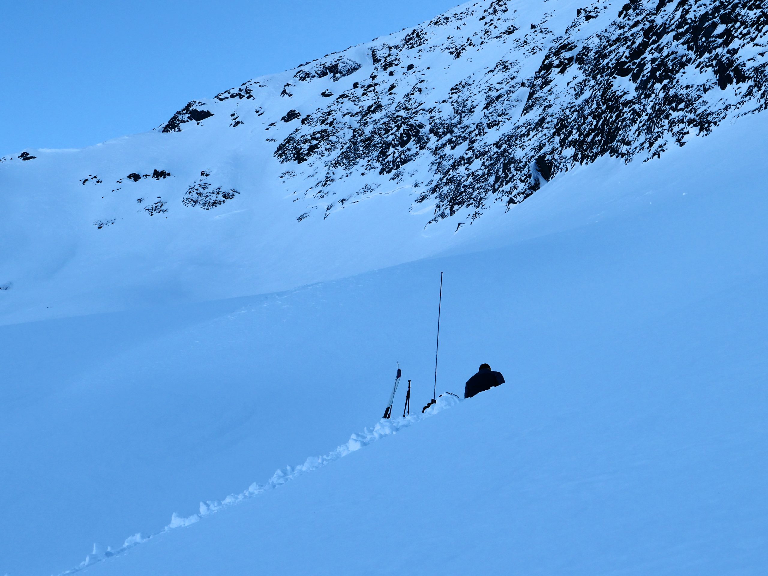
Peter Wadsworth in the snowpit yesterday, checking on those October facets right next to an old crown from the most recent avalanche cycle on that layer. 11.28.2022
Click here to view the video below if it doesn’t load in your browser.
Weather
Tue, November 29th, 2022
Yesterday: Skies cleared after a cloudy start to the day, with high temperatures in the single digits to low teens F during the day, and dropping down to the single digits above and below 0 F overnight. Winds were light out of the west at around 5 mph with gusts around 10 mph. A valley cloud had enough moisture to drop a few snowflakes around Girdwood, but it was not enough for any accumulation.
Today: Winds have increased slightly this morning, but the advisory area is looking to be protected from the northerly winds affecting Southcentral. Winds should stay around 5-10 mph out of the west, as temperatures remain in the single digits to low teens F for one more day. Skies should be mostly clear with a chance of another valley cloud near the Turnagain arm, and no precipitation is expected today.
Tomorrow: Things should remain quiet during the day tomorrow, with increasing cloud cover later in the day as a weak system moves in Wednesday night. Daytime high temperatures should climb back up into the low teens to low 20’s F, with northwesterly winds at 5-10 mph and gusts around 10-15 mph. It is looking like we might pick up an inch or two of snow Wednesday night, along with stronger winds. Stay tuned for more.
This is a general backcountry avalanche advisory issued for Turnagain Arm with Turnagain Pass as the core advisory area.
This advisory does not apply to highways, railroads or operating ski areas.