Turnagain Pass Avalanche Forecast
|
![]() ![]() |
The avalanche danger has risen to CONSIDERABLE on all aspects above 1,000′. Strong east ridgetop winds with light snowfall have begun this morning and will be forming sensitive wind slabs on any slope that is seeing active wind loading. Wind slab avalanches could be up to 2 feet deep and may occur naturally while human triggered wind slabs will be likely. Additionally, on all slopes above 1,000′, slab avalanches breaking in buried weak layers around 2 feet deep could be triggered by a person or by a smaller wind slab that steps down.
The danger below 1,000′ remains MODERATE where an avalanche occurring above may run into this zone.
No known avalanche activity from yesterday. There were several human triggered avalanches, most of them remotely triggered from the top/side, on Saturday. See them listed on Andrew’s forecast from yesterday HERE.
Signal Word | Size (D scale) | Simple Descriptor |
Small | 1 | Unlikely to bury a person |
Large | 2 | Can bury a person |
Very Large | 3 | Can destroy a house |
Historic | 4 & 5 | Can destroy part or all of a village |
A low-pressure churning in the Gulf is sending clouds, light snowfall and wind our way. Around midnight, ridgetop winds turned easterly and have climbed to the 20’s mph already with forecasted winds today in the 20-30 mph range with gusts near 50mph. Snowfall is on the modest side, with 2-3″ expected for Turnagain, 3-5″ for Girdwood and only a trace in Summit lake (a bit more tomorrow). With a welcome warm up to a more reasonable 15-25F, snow is expected to fall to sea level as temperatures in general remain below freezing,
Wind slabs and cornices are likely building as we speak and may even be releasing naturally. With upwards of 2 feet of loose snow available for transport, even on ridgetops, it should not take long for this new avalanche problem to develop. Essentially, we have fresh wind slabs forming over the top of our persistent slab issue we’ve been dealing with. More on that below.
Things to keep in mind today:
Snowfall totals expected over the next three days. We are fortunate to have such support from the Anchorage NWS Forecast Office!
Signal Word | Size (D scale) | Simple Descriptor |
Small | 1 | Unlikely to bury a person |
Large | 2 | Can bury a person |
Very Large | 3 | Can destroy a house |
Historic | 4 & 5 | Can destroy part or all of a village |
As we’ve been harping on, those weak layers under last week’s new snow are still a concern. Whether it is a layer of buried surface hoar or facets, the main point is, weak layers of snow sit around 2′ below the surface. It was evident they were still reactive on Saturday in both Turnagain and Girdwood. Several remotely triggered slabs occurred on Seattle Ridge (both sides of the ridge) and one remote triggered slab on Max’s in Girdwood Valley. Luckily, no one was caught up in any of these.
With new wind slabs forming on top of these weak layers, it’s a likely case that a wind slab avalanche could step down and trigger a larger slab, as mentioned above. However, what about those areas out of the wind? We still need to keep our guard up and look for any signs the loose snow has enough cohesion to act like a slab. Both cracking and whumpfing, along with feeling the snow with your boot or ski pole, to see if there is any stiff snow hidden under the top foot or so will good ways to assess the slope you are on.
Three pockets (small slab avalanches) that were remotely triggered from either the ridge or, more likely, from a snowmachiner out of view to the looker’s right of the slabs. Seattle Ridge, Minus 1 Bowl (Warmup Bowl), 11.27.21.
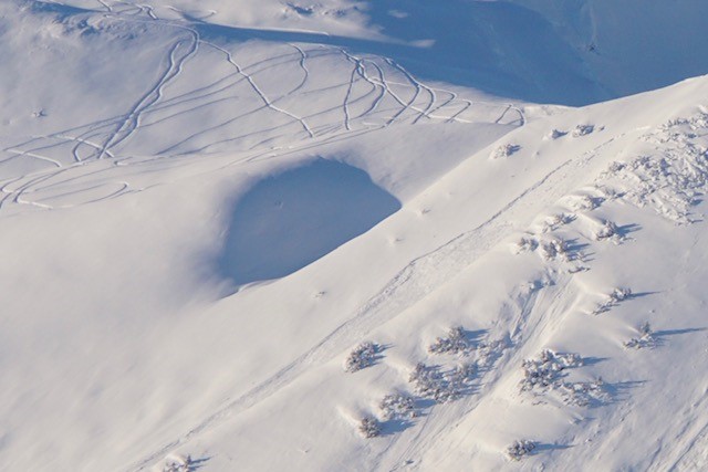
Remotely triggered slab on the SE face of Seattle Ridge by riders playing in the lower angle terrain above and to the side. Photo: Andy Moderow, 11.27.21.
Glide avalanches have really slowed down (relatively…) in the past two weeks. The last known glide crack that released was on Lipps SW face, sometime in the past week. With so many glide cracks in the area, and the fact there is no way to know when they will release, limiting your time under these is just a good idea. They really would be a horrible thing to encounter, potentially unsurvivable.
Yesterday: Mostly sunny skies quickly turned gray and cloudy by the afternoon. Ridgetop winds were light (~5mph) from a westerly direction. It was markedly cold… most stations stayed below 0F the day.
Today: Overnight, a weather system has begun to move in from the Gulf. Ridgetop winds swung easterly around midnight and bumped into the 15-20mph range with gusts in the 40’s at Sunburst. Light snowfall is starting and by tonight, 2-3″ looks to fall at Turnagain Pass and closer to 3-5″ in Girdwood. Temperatures are slowly climbing into the 10F range and should remain between 10-20F at all elevations.
Tomorrow: Snowfall is forecast to continue though tomorrow and move out on Wednesday. Another 3-5″ for Turnagain and 4-8″ for Girdwood is the guess right now, with a bit more in Portage Valley. Ridgetop winds should decrease significantly down to 5-10mph or even calm for the latter part of the storm. Temperatures will rise to near 20-30F at sea level, but this will remain cold enough for snow.
PRECIPITATION 24-hour data (6am – 6am)
Temp Avg (F) | Snow (in) | Water (in) | Snow Depth (in) | |
---|---|---|---|---|
Center Ridge (1880′) | 0 | 0 | 0 | ~63* |
Summit Lake (1400′) | -8 | 0 | 0 | ~10 |
Alyeska Mid (1700′) | 0 | N/A* | N/A* | N/A* |
*Snow depth at Center Ridge and Summit Lake are estimated. Alyeska precipitation sensors are not yet operational for the season.
RIDGETOP 24-hour data (6am – 6am)
Temp Avg (F) | Wind Dir | Wind Avg (mph) | Wind Gust (mph) | |
---|---|---|---|---|
Sunburst (3812′) | -3 | W | 5 | 41 (E 3am) |
Seattle Ridge (2400′) | -1 | VAR | 2 | 18 (SE 4am) |
Date | Region | Location | Observer |
---|---|---|---|
05/22/23 | Turnagain | Avalanche: Tincan | Nick D'Alessio |
05/12/23 | Turnagain | Avalanche: Tincan, Sunburst, Magnum, Cornbiscuit | Heather Thamm |
05/07/23 | Turnagain | Observation: Tincan – Bear Tracks | CNFAIC Staff |
05/05/23 | Turnagain | Observation: Seattle Ridge | AS/ WW Forecaster |
05/02/23 | Turnagain | Observation: Cornbiscuit | Schauer/ Sturgess Forecaster |
05/02/23 | Turnagain | Observation: Seward Hwy Turnagain Pass | Joel Curtis |
04/30/23 | Turnagain | Observation: Magnum | Ayla, Kit Crosby, Barton |
04/29/23 | Turnagain | Observation: Tincan | John Sykes |
04/28/23 | Turnagain | Avalanche: Taylor Pass/Pastoral | Schauer/ Creighton Forecaster |
04/28/23 | Turnagain | Avalanche: Tincan | Andy Moderow |
Status of riding areas across the Chugach NF is managed by the Glacier and Seward Ranger Districts, not avalanche center staff. Riding area information is posted as a public service to our users and updated based on snow depth and snow density to prevent resource damage at trailhead locations. Riding area questions contact: mailroom_r10_chugach@fs.fed.us
Area | Status | Weather & Riding Conditions |
---|---|---|
Glacier District |
Subscribe to Turnagain Pass
Avalanche Forecast by Email
This is a general backcountry avalanche advisory issued for Turnagain Arm with Turnagain Pass as the core advisory area. This advisory does not apply to highways, railroads or operating ski areas.