Turnagain Pass RSS

Archives
ARCHIVED - Forecasts expire after 24 hours.
Issued
Wed, November 29th, 2017 - 7:00AM
Expires
Thu, November 30th, 2017 - 7:00AM
Forecaster
Aleph Johnston-Bloom
Avalanche risk The Bottom Line

The avalanche danger is  CONSIDERABLE.  New snow, rain and sustained winds have loaded a weak snowpack.  Triggering a slab 1 – 2+ feet thick is likely. Natural avalanches are possible. Cautious routefinding and conservative decision-making are essential today.

*Below Treeline: ICE CLIMBERS in Portage Valley: Avalanches today could release naturally in higher terrain, sending debris over climbing routes.

Special Announcements

Motorized use on Turnagain Pass is closed due to insufficient snow cover.  Please see riding area status at the bottom of this page for the most up-to-date information.

Snowmachine Specific €“ Avalanche Safety and Lessons Learned at AMDS,  December 5th  @ 6:30 pm – 8:00 pm | FREE  Join CNFAIC forecasters at Alaska Mining and Diving Supply for a  talk about lessons learned from past avalanche events and get your brain in gear for avalanche season.

The  CNFAIC Events Calendar  is filling up with avalanche education opportunities. Check it out and find a class that is right for you!

*The forecasters want to send a shout out to the group practicing companion rescue on Tincan yesterday. Nice work! Great reminder for everyone to get out and practice with your crew!

**For Hatcher Pass avalanche conditions see  hpavalanche.org.

Wed, November 29th, 2017
Alpine
Above 2,500'
3 - Considerable
Avalanche risk
Treeline
1,000'-2,500'
3 - Considerable
Avalanche risk
Below Treeline
Below 1,000'
3 - Considerable
Avalanche risk
0 - No Rating
1 - Low
2 - Moderate
3 - Considerable
4 - High
5 - Extreme
Avalanche risk Avalanche risk Avalanche risk Avalanche risk Avalanche risk
Travel Advice Generally safe avalanche conditions. Watch for unstable snow on isolated terrain features. Heightened avalanche conditions on specific terrain features. Evaluate snow and terrain carefully; identify features of concern. Dangerous avalanche conditions. Careful snowpack evaluation, cautious route-finding, and conservative decision-making essential. Very dangerous avalanche conditions. Travel in avalanche terrain not recommended. Extraordinarily dangerous avalanche conditions. Avoid all avalanche terrain.
Likelihood of Avalanches Natural and human-triggered avalanches unlikely. Natural avalanches unlikely; human-triggered avalanches possible. Natural avalanches possible; human-triggered avalanches likely. Natural avalanches likely; human-triggered avalanches very likely. Natural and human-triggered avalanches certain.
Avalanche Size and Distribution Small avalanches in isolated areas or extreme terrain. Small avalanches in specific areas; or large avalanches in isolated areas. Small avalanches in many areas; or large avalanches in specific areas; or very large avalanches in isolated areas. Large avalanches in many areas; or very large avalanches in specific areas. Very large avalanches in many areas.
Avalanche Problem 1
  • Storm Slabs
    Storm Slabs
Storm Slabs
Storm Slab avalanches are the release of a cohesive layer (a slab) of new snow that breaks within new snow or on the old snow surface. Storm-slabs typically last between a few hours and few days (following snowfall). Storm-slabs that form over a persistent weak layer (surface hoar, depth hoar, or near-surface facets) may be termed Persistent Slabs or may develop into Persistent Slabs.
More info at Avalanche.org

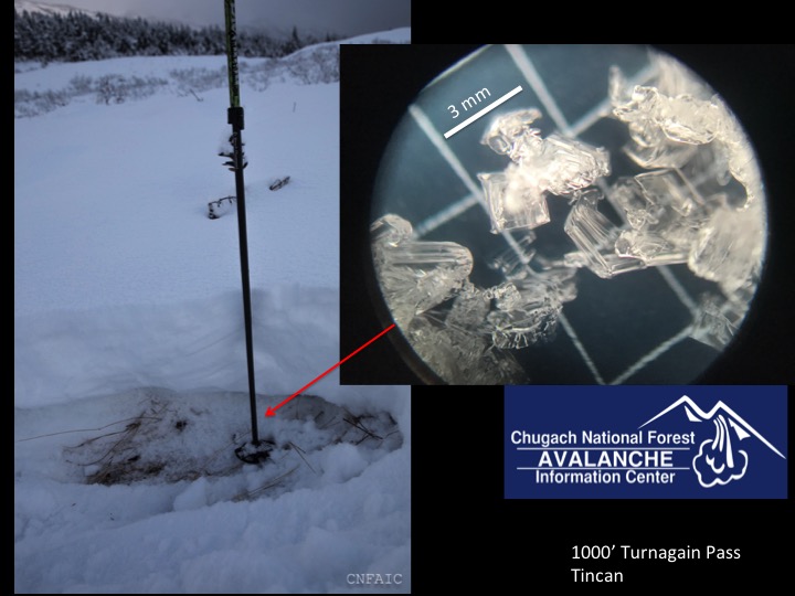
New snow, rain and sustained winds overnight have elevated the avalanche danger. 8-10″ of snow fell at upper elevations in Girdwood and 5-8″ at Turnagain in the last 24 hrs. Winds were easterly 20-30 mph with gusts into the 50s.  Unfortunately some of the precipitation has fallen as… yuck, rain to around 1500′, maybe a bit higher. It is 34F at the Center Ridge Snotel (1880′) this morning. Yesterday the balance had not quite been tipped by new snow and wind loading but there was widespread cracking, whumpfing and a recent small natural avalanche observed (red flags). Hand pits showed failure on isolation between new snow and the underlying facets. This weak snow rests either on the ground or overlying a melt-freeze crust near the ground. With the additional snow and wind loading overnight this now sits below a more cohesive slab. Triggering a slab on steep terrain will be likely, especially in leeward, wind loaded areas. This snowpack set-up has the potential to be very touchy. Collapses (whumpfs) may propagate failure over large pieces of terrain and remote triggering an avalanche is possible. Don’t let early season stoke lure you into a dangerous spot. Overall it is still fairly shallow and rocky, getting caught in an avalanche could take you for a very unpleasant ride. Rain falling on this snowpack will also add weight and break up bonds. Wet loose avalanches may run naturally at low elevations in steep channeled terrain.

Quick snowpit at 1000′ near large collapse. Weak facets below new snow. 

Cracking in snowpack near skin track, propagating across terrain. 

Weather
Wed, November 29th, 2017

Yesterday was mostly overcast with light precipitation on and off throughout the day. Turnagain saw a few breaks in the clouds. Winds were easterly 10-20 during the day, ramping up overnight into the 30s with gusts into the 50s. Overnight snow picked up and rain fell to around 1500′. 8-10″ of snow fell at upper elevations in Girdwood with .6-1″ of SWE (snow water equivalent). Turnagain picked up 5-8″ at .5 SWE. Temperatures were in the mid 30Fs to mid 20Fs depending on elevation.

Today will be mostly cloudy with snow showers. These showers may be locally heavier at times due to unstable air behind the current front. An additional 1-5″ of snow is forecasted to fall. Winds will be easterly 10-20 mph with gusts into the 30s. Rain/snowline is expected to drop as temperatures cool down in the afternoon/evening.  Temperatures will be in the mid 30Fs to mid 20Fs. Light snow showers may continue overnight.

Thursday will be mostly to partly cloudy and cooler with a wind shift to the NW. Temperatures will be in the 20Fs dipping into the teens at night. There is a break in the stormy pattern on Friday before more unsettled weather moves in again over the weekend.

PRECIPITATION 24-hour data (6am – 6am)

Temp Avg (F) Snow (in) Water (in) Snow Depth (in)
Center Ridge (1880′)  34  6 .5 12
Summit Lake (1400′)  32  0  0 7
Alyeska Mid (1700′)  32  8 .6  14

RIDGETOP 24-hour data (6am – 6am)

Temp Avg (F) Wind Dir Wind Avg (mph) Wind Gust (mph)
Sunburst (3812′)  23 ENE  28 56
Seattle Ridge (2400′)  26 rimed rimed  rimed
Observations
Recent Observations for Turnagain Pass
Date Region Location
04/15/24 Turnagain Observation: Taylor Pass
04/14/24 Turnagain Observation: Sunburst
04/14/24 Turnagain Observation: Turnagain Pass Snomo
04/13/24 Turnagain Observation: Spokane Creek
04/11/24 Turnagain Observation: Tincan
04/10/24 Turnagain Avalanche: Seattle Ridge
04/10/24 Turnagain Observation: Cornbiscuit South Face
04/10/24 Turnagain Avalanche: Tincan
04/10/24 Turnagain Avalanche: Cornbiscuit
04/07/24 Turnagain Observation: Seattle Creek Headwall
Riding Areas

The riding areas page has moved. Please click here & update your bookmarks.


Subscribe to Turnagain Pass
Avalanche Forecast by Email

This is a general backcountry avalanche advisory issued for Turnagain Arm with Turnagain Pass as the core advisory area. This advisory does not apply to highways, railroads or operating ski areas.