Turnagain Pass Avalanche Forecast
|
![]() ![]() |
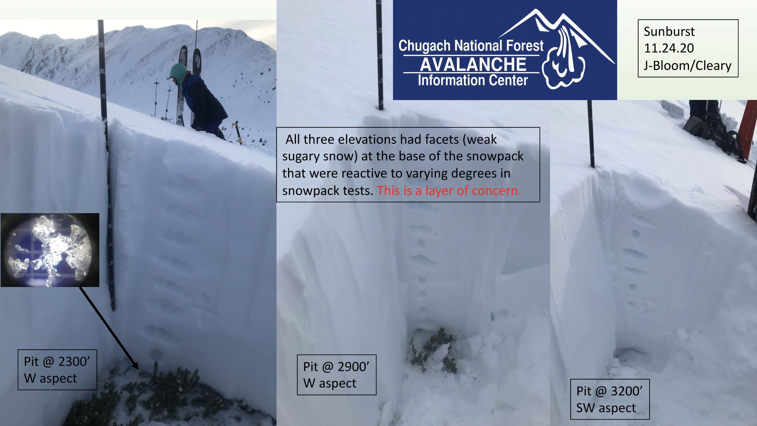
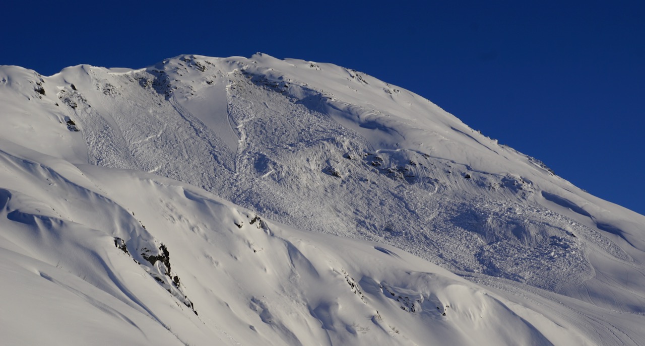
The avalanche danger is CONSIDERABLE today and tomorrow. Human triggered large avalanches remain likely above 1000′ on all aspects. Avalanches can be triggered by people on a slope or remotely, from the side or below. They could fail near the ground, taking the entire snowpack down the mountain. Cautious route-finding and conservative decision-making are essential.
UPDATE, Friday Outlook: Another system will impact the region Friday keeping avalanche danger elevated. Watch for changing conditions with new snow and wind. Natural avalanches are possible late Friday if this storm verifies.
Happy Thanksgiving from the CNFAIC staff. Have a safe and happy holiday!
Signal Word | Size (D scale) | Simple Descriptor |
Small | 1 | Unlikely to bury a person |
Large | 2 | Can bury a person |
Very Large | 3 | Can destroy a house |
Historic | 4 & 5 | Can destroy part or all of a village |
With another foot of snow falling yesterday, accompanied by very strong easterly winds, we are in a spooky spot today and tomorrow. There is the potential for a person on a snowmachine or skis to trigger a large, destructive avalanche. Unfortunately lurking beneath all this new snow are two buried weak layers. The storm on November 20th buried a layer of surface hoar mid-pack and there are weak (sugary) facets at the base. Both these layers produced large human triggered avalanches on Sunday. We have even more snow load now. Avalanches could break anywhere from 1-5′ deep, maybe even deeper.
With better visibility today and tomorrow it will be tempting to push it. It is crucial to keep it mellow and give the snowpack time to adjust. Be on the lookout for signs of instability. Recent avalanches, whumpfing/collapsing and shooting cracks are all indications that the snowpack is stressed. Ease into terrain. Avalanches could be triggered remotely today, from the side or below. In addition, it might not be the first rider or skier on the slope that triggers the avalanche. There may be tracks already and the 5 person out tips the balance. Choose terrain wisely, have escape routes planned and watch out for other groups in the area. Sticking to low angle slopes, and out from under larger slopes, is a great way to enjoy the new snow and make it home for some Thanksgiving dinner.
Four feet of snow on the ground at 1000′ means there could be avalanches 4′ deep or even deeper. It also means there is lots of fun to be had in lower angle terrain today, out of harm’s way. DOT stake. 11.25.20
View of the Hippy Bowl remote triggered avalanche from 11.22.20. There is the potential for this type of avalanche today but even larger and more destructive.
Signal Word | Size (D scale) | Simple Descriptor |
Small | 1 | Unlikely to bury a person |
Large | 2 | Can bury a person |
Very Large | 3 | Can destroy a house |
Historic | 4 & 5 | Can destroy part or all of a village |
Yesterday’s storm was ‘upside down’. Snowfall started with slightly colder temperatures and then warmed up creating an 8-10″ layer of heavier snow over lighter snow. Today there is the potential for the denser layer to behave like a slab. In addition, the snowfall was accompanied by strong easterly winds. Keep your eyes peeled for areas winds have deposited snow, pillowed surfaces, stiffer wind packed snow and shooting cracks. Triggering a storm slab or wind slab avalanche in the upper layers of snowpack could step down and trigger a much larger avalanche that breaks in buried surface hoar mid-pack or in weak snow near the ground.
Yesterday: Rain and snow throughout the day with rain/snow line around 500′. A foot of new snow (1.0″ SWE) fell across the advisory area. Winds were easterly 20-50 mph gusting into the 90s. Winds eased off in the in late afternoon. Temperatures were in the mid 20°Fs to mid 30°Fs. Overnight there were snow showers, easterly winds 10-20 mph with gusts into the 30s. Temperatures were in the high teens to high 20°Fs.
Today: Skies will be partly cloudy to mostly sunny and winds will be light and easterly. Temperatures will be in the high teens to high 20°Fs. Clouds will build in the evening with snow showers overnight and 2-5″ in the forecast. East winds 5-15 mph gusting into the 30s and temperatures in the 20°Fs.
Tomorrow: Skies will be partly cloudy and scattered snow showers are possible. Winds will be mostly calm and temperatures will remain in the 20°Fs. Another round of snow is on tap for Saturday. Fun quote from the NWS discussion this morning, ‘There is seemingly no end in sight to the supply of large deep storm systems traversing the Alaska region’. #snowtosealevelplease
PRECIPITATION 24-hour data (6am – 6am)
Temp Avg (F) | Snow (in) | Water (in) | Snow Depth (in) | |
---|---|---|---|---|
Center Ridge (1880′) | 31 | 7 | 1.0 | 44 |
Summit Lake (1400′) | 31 | 6 | 0.6 | 17 |
Alyeska Mid (1700′) | 31 | 13 | 0.9 | 48 |
RIDGETOP 24-hour data (6am – 6am)
Temp Avg (F) | Wind Dir | Wind Avg (mph) | Wind Gust (mph) | |
---|---|---|---|---|
Sunburst (3812′) | 21 | NE | 26 | 95 |
Seattle Ridge (2400′) | 24 | SE | 10 | 85 |
Date | Region | Location | Observer |
---|---|---|---|
05/22/23 | Turnagain | Avalanche: Tincan | Nick D'Alessio |
05/12/23 | Turnagain | Avalanche: Tincan, Sunburst, Magnum, Cornbiscuit | Heather Thamm |
05/07/23 | Turnagain | Observation: Tincan – Bear Tracks | CNFAIC Staff |
05/05/23 | Turnagain | Observation: Seattle Ridge | AS/ WW Forecaster |
05/02/23 | Turnagain | Observation: Cornbiscuit | Schauer/ Sturgess Forecaster |
05/02/23 | Turnagain | Observation: Seward Hwy Turnagain Pass | Joel Curtis |
04/30/23 | Turnagain | Observation: Magnum | Ayla, Kit Crosby, Barton |
04/29/23 | Turnagain | Observation: Tincan | John Sykes |
04/28/23 | Turnagain | Avalanche: Taylor Pass/Pastoral | Schauer/ Creighton Forecaster |
04/28/23 | Turnagain | Avalanche: Tincan | Andy Moderow |
Status of riding areas across the Chugach NF is managed by the Glacier and Seward Ranger Districts, not avalanche center staff. Riding area information is posted as a public service to our users and updated based on snow depth and snow density to prevent resource damage at trailhead locations. Riding area questions contact: mailroom_r10_chugach@fs.fed.us
Area | Status | Weather & Riding Conditions |
---|---|---|
Glacier District |
Subscribe to Turnagain Pass
Avalanche Forecast by Email
This is a general backcountry avalanche advisory issued for Turnagain Arm with Turnagain Pass as the core advisory area. This advisory does not apply to highways, railroads or operating ski areas.