Turnagain Pass RSS

Archives
ARCHIVED - Forecasts expire after 24 hours.
Issued
Wed, November 24th, 2021 - 7:00AM
Expires
Thu, November 25th, 2021 - 7:00AM
Forecaster
Andrew Schauer
Avalanche risk The Bottom Line

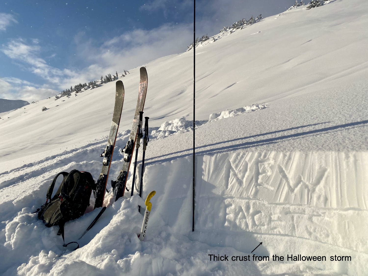
The avalanche danger will remain CONSIDERABLE above 2500’ today. It is still likely a person could trigger an avalanche 1-2’ deep or deeper in yesterday’s storm snow, which brought 12-16″ snow along with strong ridgetop winds. While wind loaded slopes will be the most sensitive, there is enough storm snow on top of weak, sugary facets to make for dangerous avalanche conditions on sheltered slopes too. Safe travel in the alpine will require careful route finding, and approaching steep slopes with caution.

The danger is MODERATE below 2500’, where it will be possible to trigger an avalanche a foot deep in the storm snow from yesterday. If you notice warning signs like shooting cracks or fresh avalanches, stick to lower angle terrain to stay out of harm’s way.

Special Announcements
  • The Turnagain Pass motorized areas will remain closed until we get better low elevation coverage. Yesterday’s storm has gotten us closer, but it still needs a little bit more to open. You can find more info hereand keep your fingers crossed for another couple feet of low elevation snow so we can start riding!
  • Our non-profit arm, Friends of the Chugach Avalanche Center, is looking for a volunteer to work on the website. Contact chugachavyfriends@gmail.com for more information.
  • We will be hosting several ‘Forecaster Chats’ this December into January. Stay tuned for dates and topics.
Wed, November 24th, 2021
Alpine
Above 2,500'
3 - Considerable
Avalanche risk
Treeline
1,000'-2,500'
2 - Moderate
Avalanche risk
Below Treeline
Below 1,000'
2 - Moderate
Avalanche risk
0 - No Rating
1 - Low
2 - Moderate
3 - Considerable
4 - High
5 - Extreme
Avalanche risk Avalanche risk Avalanche risk Avalanche risk Avalanche risk
Travel Advice Generally safe avalanche conditions. Watch for unstable snow on isolated terrain features. Heightened avalanche conditions on specific terrain features. Evaluate snow and terrain carefully; identify features of concern. Dangerous avalanche conditions. Careful snowpack evaluation, cautious route-finding, and conservative decision-making essential. Very dangerous avalanche conditions. Travel in avalanche terrain not recommended. Extraordinarily dangerous avalanche conditions. Avoid all avalanche terrain.
Likelihood of Avalanches Natural and human-triggered avalanches unlikely. Natural avalanches unlikely; human-triggered avalanches possible. Natural avalanches possible; human-triggered avalanches likely. Natural avalanches likely; human-triggered avalanches very likely. Natural and human-triggered avalanches certain.
Avalanche Size and Distribution Small avalanches in isolated areas or extreme terrain. Small avalanches in specific areas; or large avalanches in isolated areas. Small avalanches in many areas; or large avalanches in specific areas; or very large avalanches in isolated areas. Large avalanches in many areas; or very large avalanches in specific areas. Very large avalanches in many areas.
Avalanche Problem 1
  • Storm Slabs
    Storm Slabs
  • Certain
    Very Likely
    Likely
    Possible
    Unlikely
    Likelihood
  • Historic (D4-5)
    Very Large (D3)
    Large (D2)
    Small (D1)
    Size
Storm Slabs
Storm Slab avalanches are the release of a cohesive layer (a slab) of new snow that breaks within new snow or on the old snow surface. Storm-slabs typically last between a few hours and few days (following snowfall). Storm-slabs that form over a persistent weak layer (surface hoar, depth hoar, or near-surface facets) may be termed Persistent Slabs or may develop into Persistent Slabs.

Likelihood of Avalanches
Terms such as "unlikely", "likely", and "certain" are used to define the scale, with the chance of triggering or observing avalanches increasing as we move up the scale. For our purposes, "Unlikely" means that few avalanches could be triggered in avalanche terrain and natural avalanches are not expected. "Certain" means that humans will be able to trigger avalanches on many slopes, and natural avalanches are expected.

Size of Avalanches
Avalanche size is defined by the largest potential avalanche, or expected range of sizes related to the problem in question. Assigned size is a qualitative estimate based on the destructive classification system and requires specialists to estimate the harm avalanches may cause to hypothetical objects located in the avalanche track (AAA 2016, CAA 2014). Under this schema, "Small" avalanches are not large enough to bury humans and are relatively harmless unless they carry people over cliffs or through trees or rocks. Moving up the scale, avalanches become "Large" enough to bury, injure, or kill people. "Very Large" avalanches may bury or destroy vehicles or houses, and "Historic" avalanches are massive events capable of altering the landscape.

Signal Word Size (D scale) Simple Descriptor
Small 1 Unlikely to bury a person
Large 2 Can bury a person
Very Large 3 Can destroy a house
Historic 4 & 5 Can destroy part or all of a village
More info at Avalanche.org

Conditions will still be dangerous today after the surprise storm from yesterday. We received 12-14″ snow by late yesterday morning, and had around 4″ fall last night. Light snowfall is expected to continue to trickle in, bringing another 3 or 4″ throughout the day. Easterly ridgetop winds are expected to continue at 15-25 mph until they start to calm down and switch to the west midday. All of this means the weather machine is hard at work putting a lot of new snow on top of weak, sugary facets. It is likely a human could trigger an avalanche on these weak layers, which could be 2′ deep or deeper, especially on upper-elevation wind loaded slopes.

The weather will be relatively quiet today, but avalanche conditions will still be touchy. The light and fluffy storm snow will start to settle into a more cohesive slab, which might make it easier to trigger a storm slab avalanche today than it was yesterday. Today will be a day to be careful with your route finding, approaching steep terrain with caution. Pay attention to clear warning signs of instability like shooting cracks and fresh avalanche activity, and dial back your terrain accordingly.

Wind Slabs: Some higher elevation slopes will have fresh wind slabs on the surface, which will be extra sensitive. These will most likely be found immediately below ridgelines, convexities, or in gullies. It will be especially easy to trigger an avalanche on these wind loaded features.

Wendy discusses the storm slab problem in this video from Seattle Ridge yesterday:

Snowpit near the Seattle Ridge uptrack yesterday. 14″ of new snow is sitting on top of weak facets. 11.23.2021

Additional Concern
  • Glide Avalanches
    Glide Avalanches
Glide Avalanches
Glide Avalanches are the release of the entire snow cover as a result of gliding over the ground. Glide avalanches can be composed of wet, moist, or almost entirely dry snow. They typically occur in very specific paths, where the slope is steep enough and the ground surface is relatively smooth. They are often proceeded by full depth cracks (glide cracks), though the time between the appearance of a crack and an avalanche can vary between seconds and months. Glide avalanches are unlikely to be triggered by a person, are nearly impossible to forecast, and thus pose a hazard that is extremely difficult to manage.
More info at Avalanche.org

Glide activity seems to have slowed down in the past few days, but that doesn’t mean the hazard is gone. Glide avalanches are hard to predict, and they involve the entire snowpack so they are large and very dangerous. Be on the lookout for glide cracks, and limit the time you spend traveling below them.

Weather
Wed, November 24th, 2021

Yesterday: Another 2″ snow fell yesterday morning, with 3-4″ overnight last night. Easterly ridgetop winds were blowing 20-30 mph with gusts as high as 50 mph, but winds were much lighter at mid and lower elevations. High temperatures reached the teens to low 20’s F during the day, and overnight lows were in the single digits F. Skies were mostly cloudy, with the occasional ray of sunshine poking through.

Today: Light snowfall will continue to trickle in, which might amount to another 3-4″ throughout the day. Easterly winds will continue to blow at 10-25 mph, approaching 30 mph at the higher ridgetops. Winds should ease off and switch to blow out of the west late in the afternoon. High temperatures are expected in the low teens, with lows in the single digits.

Tomorrow: Cold air will start to move back into the area tomorrow, with temperatures struggling to get out of the single digits F during the day and dropping below 0 F tomorrow night. Westerly winds should remain light at 5-10 mph, and skies will be mostly cloudy.

PRECIPITATION 24-hour data (6am – 6am)

Temp Avg (F) Snow (in) Water (in) Snow Depth (in)
Center Ridge (1880′) 14 N/A* 0.5 N/A*
Summit Lake (1400′) 7 tr tr 11
Alyeska Mid (1700′) 12 3* .1* N/A*

*Sensors were not recording for part or all of the day. SWE and Snow totals are estimates.

RIDGETOP 24-hour data (6am – 6am)

Temp Avg (F) Wind Dir Wind Avg (mph) Wind Gust (mph)
Sunburst (3812′) 9 ENE 16 50
Seattle Ridge (2400′) 9 E 7 21
Observations
Recent Observations for Turnagain Pass
Date Region Location
04/23/24 Turnagain Observation: Turnagain Sunny Side
04/21/24 Turnagain Observation: Bertha Creek
04/20/24 Turnagain Avalanche: Spokane Creek
04/16/24 Turnagain Observation: Cornbiscuit
04/15/24 Turnagain Observation: Taylor Pass
04/15/24 Turnagain Observation: Seward Highway – Tern Lake to Portage
04/14/24 Turnagain Observation: Sunburst
04/14/24 Turnagain Observation: Turnagain Pass Snomo
04/13/24 Turnagain Observation: Spokane Creek
04/11/24 Turnagain Observation: Tincan
Riding Areas

The riding areas page has moved. Please click here & update your bookmarks.


Subscribe to Turnagain Pass
Avalanche Forecast by Email

This is a general backcountry avalanche advisory issued for Turnagain Arm with Turnagain Pass as the core advisory area. This advisory does not apply to highways, railroads or operating ski areas.