Turnagain Pass Avalanche Forecast
|
![]() ![]() |
The avalanche danger is CONSIDERABLE at all elevation bands. In the Alpine and Treeline, triggering a slab avalanche is likely. Avalanches may be triggered remotely. Avalanches that release in higher elevation terrain could send debris into the lower elevation (below 1000′) runout. Cautious route-finding and conservative decision-making are essential.
Signal Word | Size (D scale) | Simple Descriptor |
Small | 1 | Unlikely to bury a person |
Large | 2 | Can bury a person |
Very Large | 3 | Can destroy a house |
Historic | 4 & 5 | Can destroy part or all of a village |
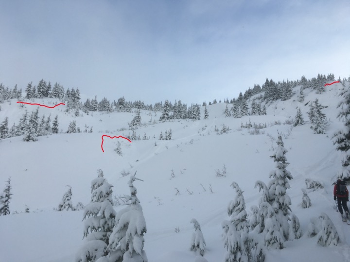
Viva La Niña! Winter is off to a promising start. However, caution is advised. There is a long winter ahead. Don’t let early season stoke get the best of you! Around 2′ of snow (2.0″ of SWE) has fallen in the mid to upper elevation terrain in Girdwood Valley and Turnagain Pass since Friday afternoon. Unfortunately this snow fell on weak surface snow (small facets and surface hoar) and there is weak snow near the ground (more on this in Avalanche Problem 2). In addition, there were strong sustained winds Friday evening into Saturday morning. Observers yesterday reported all the signs of instability. There were both natural and human triggered avalanches, large whumpfs and shooting cracks. This included avalanches large enough to bury a person in the Tincan Trees.
Light snow is falling this morning but there is a bit of a break forecasted between storms today. Don’t let a window of improving visibility lure you into bigger terrain. Human triggered avalanches are likely today. With the current snowpack structure there is the potential for avalanches to be triggered remotely. It’s a day to carefully evaluate terrain and consequences if an avalanche does release and pay attention to other groups around you. With more snow and strong winds expected again tonight and tomorrow, this is the time to be patient, the snowpack will need time to adjust to all this loading.
As a reminder, here are the Red Flags to look for:
– Recent avalanches
– Whumpfing (collapsing) of the snowpack
– Shooting cracks
Signal Word | Size (D scale) | Simple Descriptor |
Small | 1 | Unlikely to bury a person |
Large | 2 | Can bury a person |
Very Large | 3 | Can destroy a house |
Historic | 4 & 5 | Can destroy part or all of a village |
As mentioned above there is weak snow at the base of the snowpack. This means that not only are we concerned about an avalanche failing at the new snow/old snow interface but there is the potential for an avalanche to fail in the facets (sugar snow) at the ground. One of the large natural avalanches observed yesterday on Tincan Proper is believed to have run to the ground. We have been mentioning poor snowpack structure as a concern for a couple weeks and now there is an even bigger slab on top of the weak October snow. Triggering this set-up could produce a large and deadly avalanche. This type of avalanche (Persistent Slab) could be triggered remotely (from above, below or from the side of the slope). This set-up could be an issue for days or weeks to come and should be front and center when choosing what terrain to ride.
Yesterday: Skies were cloudy with periods of heavy snow above 800′ and rain falling at sea level in the morning. Skies became broken in the afternoon. Winds were easterly 20-40 mph in the early morning gusting into the 60s and eased off late morning. Temperatures were in the low 30Fs at sea level to low 20Fs in the Alpine. Overnight skies were cloudy with snow showers, light winds and temperatures in the 20Fs to low 30Fs.
Today: Snow showers this morning becoming partly cloudy this afternoon. Light east winds and temperatures in the high 20Fs. Snow showers starting again in the late evening and east-northest winds picking up overnight. Temperatures in the mid 20Fs to low 30Fs.
Tomorrow: Snow likely with east-northeast winds 25-35 mph gusting into the 40s and temperatures in the 20Fs to low 30Fs.
PRECIPITATION 24-hour data (6am – 6am)
Temp Avg (F) | Snow (in) | Water (in) | Snow Depth (in) | |
---|---|---|---|---|
Center Ridge (1880′) | 30 | 10 | 1.0 | 34 |
Summit Lake (1400′) | 29 | 2 | 0.2 | 11 |
Alyeska Mid (1700′) | 31 | 10 | 1.12 | 37 |
RIDGETOP 24-hour data (6am – 6am)
Temp Avg (F) | Wind Dir | Wind Avg (mph) | Wind Gust (mph) | |
---|---|---|---|---|
Sunburst (3812′) | 21 | NE | 21 | 68 |
Seattle Ridge (2400′) | 25 | SE | 9* | 26* |
*Seattle Ridge weather station is likely rimed and under reporting.
Date | Region | Location | Observer |
---|---|---|---|
05/22/23 | Turnagain | Avalanche: Tincan | Nick D'Alessio |
05/12/23 | Turnagain | Avalanche: Tincan, Sunburst, Magnum, Cornbiscuit | Heather Thamm |
05/07/23 | Turnagain | Observation: Tincan – Bear Tracks | CNFAIC Staff |
05/05/23 | Turnagain | Observation: Seattle Ridge | AS/ WW Forecaster |
05/02/23 | Turnagain | Observation: Cornbiscuit | Schauer/ Sturgess Forecaster |
05/02/23 | Turnagain | Observation: Seward Hwy Turnagain Pass | Joel Curtis |
04/30/23 | Turnagain | Observation: Magnum | Ayla, Kit Crosby, Barton |
04/29/23 | Turnagain | Observation: Tincan | John Sykes |
04/28/23 | Turnagain | Avalanche: Taylor Pass/Pastoral | Schauer/ Creighton Forecaster |
04/28/23 | Turnagain | Avalanche: Tincan | Andy Moderow |
Status of riding areas across the Chugach NF is managed by the Glacier and Seward Ranger Districts, not avalanche center staff. Riding area information is posted as a public service to our users and updated based on snow depth and snow density to prevent resource damage at trailhead locations. Riding area questions contact: mailroom_r10_chugach@fs.fed.us
Area | Status | Weather & Riding Conditions |
---|---|---|
Glacier District |
Subscribe to Turnagain Pass
Avalanche Forecast by Email
This is a general backcountry avalanche advisory issued for Turnagain Arm with Turnagain Pass as the core advisory area. This advisory does not apply to highways, railroads or operating ski areas.