Turnagain Pass Avalanche Forecast
|
![]() ![]() |
The avalanche danger is MODERATE at all elevations. Triggering a wet loose avalanche is possible on slopes ~35 degrees or steeper that harbor boot-top wet and saturated snow. Pay close attention to the amount of re-freeze that may, or may not, have occurred overnight and how the surface is warming through the day. Avoid being under glide cracks and give cornices a wide berth.
CROW PASS, PORTAGE VALLEY: Be cautious of summer trails that pass under/through avalanche paths, such as the Byron Glacier Trail and Crow Pass Trail. Although natural avalanches are not expected today or Friday, it is best practice to avoid being in any avalanche runout zone in the late afternoon/evening hours when daytime heating can destabilize snow from above.
FRIDAY AVALANCHE OUTLOOK: No avalanche forecast will be issued tomorrow. Expect similar avalanche danger for Friday. If the sun shines tomorrow, watch for sunlit slopes to soften quickly.
CNFAIC End Of Season Operations: Daily avalanche forecasts have ended. Our last forecast will be Saturday morning with our Springtime Tips posted on Sunday afternoon. We are grateful for any observations if you happen to get out and about!
Signal Word | Size (D scale) | Simple Descriptor |
Small | 1 | Unlikely to bury a person |
Large | 2 | Can bury a person |
Very Large | 3 | Can destroy a house |
Historic | 4 & 5 | Can destroy part or all of a village |
After a glorious 12-day stretch of sunshine, clouds streamed over the region yesterday evening and are slated to remain through today and into the beginning of tomorrow. There may be a few rain drops out there this evening, but those should stay closer to Whittier and Seward. Although temperatures are cooler, the cloud cover has limited the amount of overnight re-freeze; clouds tonight will likely limit the re-freeze for Friday as well. With temperatures in the upper elevations below freezing, those areas should have a solid crust, but it’s the mid and lower elevations that will be questionable. Hence, how much re-freeze has occurred? This is the question for anyone headed out to find some corn snow.
Keep in mind that triggering a wet loose avalanche is the main concern. This should be relatively easy to suss out as it completely depends on how wet the snow we are traveling on is. Slopes that are frozen, or those with just a few inches of soft snow over a hard crust are not an issue. But… once they warm enough that your boot or snowmachine starts to punch into 10+” of mush or so, it’s high time to head somewhere else. Either out of avalanche terrain or to slopes with less wet snow.
As for Wet slab avalanches, these remain on our mind, especially with the potential for a limited re-freeze and water slowly making its way down into the pack. For the next couple days this concern is mainly below around 3,000′ due to the colder temperatures in the high elevations. The rules are the same for this avalanche issue; steer clear of slopes with boot-top wet and saturated snow. Wet slabs are often triggered by a wet loose avalanche and can turn a small avalanche into a much larger and dangerous one.
Cornices: The past 12 days of warm temperatures is causing looming cornices to slowly droop. These are most unstable in the heat of the day, but should be suspect anytime. A cornice fall could trigger a wet avalanche on the slope below when conditions are ripe. Be aware to not accidentally travel onto one and limit any exposure under them.
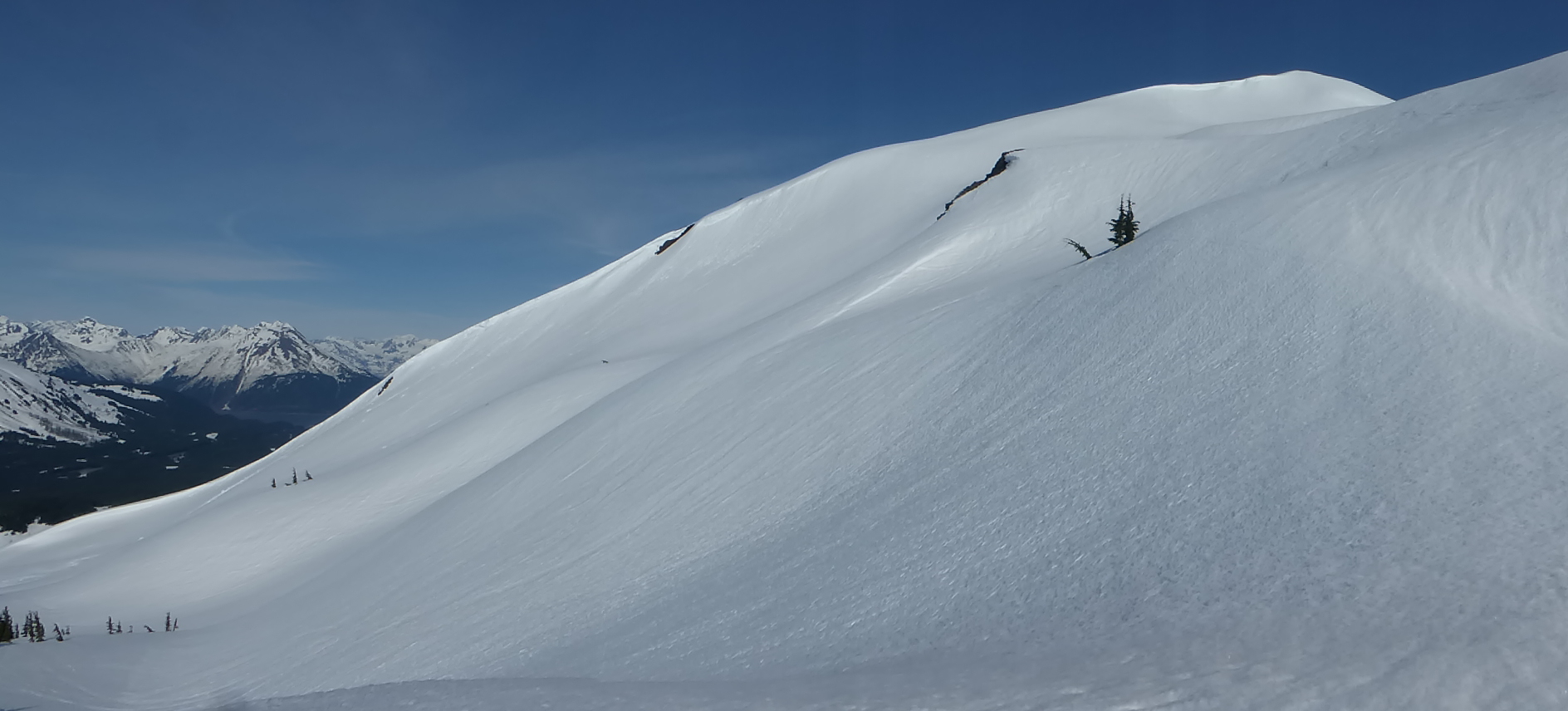
Tincan’s west face, just above treeline. A lot of snow still remains out there! 4.27.21. Joe Kurtak.
Pastoral Peak, seen from Sunburst/Taylor Pass, last Friday, 4.23.21 by Troy Tempel.
Glide cracks will be something to keep our eye on as long as snow covers the hillsides. These cracks can release into a destructive avalanche at anytime. It has been several days since we’ve heard of any cracks releasing. That said, there have not been many folks out in general to see them if there have been some failing. As always, watch for these and limit time, or avoid if possible, being under them.
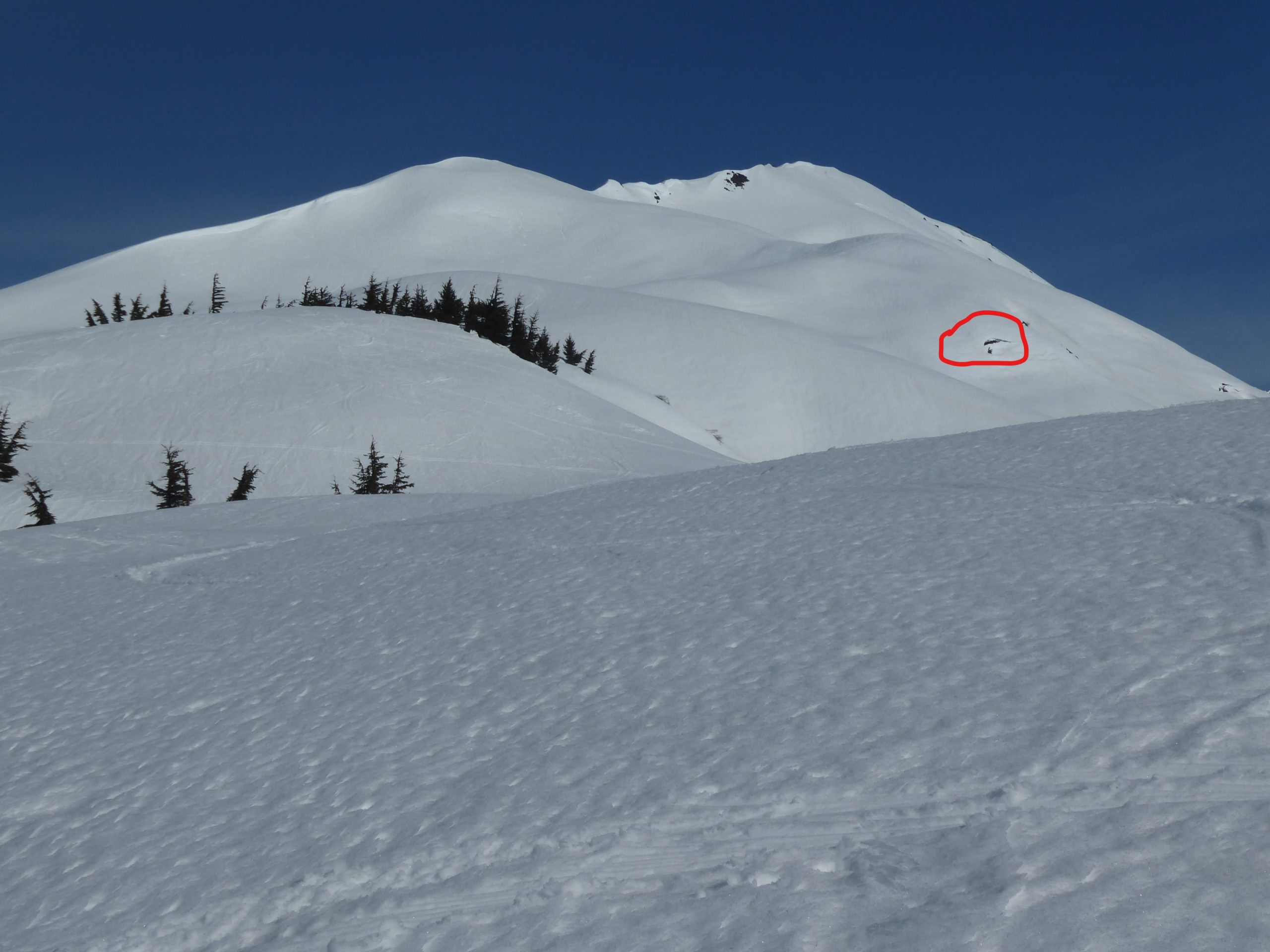
Glide crack on Tincan. Photo taken Tuesday (4.27.21) by Joe Kurtak.
Yesterday: Mostly sunny skies turned cloudy late in the day as a weak front pushed in from the south. Ridgetop winds were easterly in the 10-15mph range with gusts in the 20’sF during the day and have quieted down overnight. Temperatures climbed to the 40’sF in the mid elevations and have dropped back to the 30’s overnight.
Today: Mostly cloudy skies are expected to remain through today. A rain drop or two might fall but no measurable precipitation is expected in Girdwood or Turnagain Pass. Ridgetop winds are slated to shift northwesterly midday (5-10mph) as a trough pushes in from the west. This will bring in cooler temperatures and daytime high’s look to be in the low 40’sF at the lower and mid elevations and mid 30’sF along the ridgelines.
Tomorrow: Skies should begin to clear tomorrow with the potential for sunshine later in the day and into Saturday. Ridgetop winds look to be 5-15mph from the northwest Friday and switching back to the east (5-10mph) on Saturday. Temperatures will remain on the chiller side with high’s in the 40’sF at mid elevations and low’s in the 30’sF.
PRECIPITATION 24-hour data (6am – 6am)
Temp Avg (F) | Snow (in) | Water (in) | Snow Depth (in) | |
---|---|---|---|---|
Center Ridge (1880′) | 40 | 0 | 0 | 89 |
Summit Lake (1400′) | 42 | 0 | 0 | 27 |
Alyeska Mid (1700′) | 42 | 0 | 0 | 99 |
RIDGETOP 24-hour data (6am – 6am)
Temp Avg (F) | Wind Dir | Wind Avg (mph) | Wind Gust (mph) | |
---|---|---|---|---|
Sunburst (3812′) | 30 | NE | 13 | 28 |
Seattle Ridge (2400′) | 33 | SE | 8 | 18 |
Date | Region | Location | Observer |
---|---|---|---|
05/22/23 | Turnagain | Avalanche: Tincan | Nick D'Alessio |
05/12/23 | Turnagain | Avalanche: Tincan, Sunburst, Magnum, Cornbiscuit | Heather Thamm |
05/07/23 | Turnagain | Observation: Tincan – Bear Tracks | CNFAIC Staff |
05/05/23 | Turnagain | Observation: Seattle Ridge | AS/ WW Forecaster |
05/02/23 | Turnagain | Observation: Cornbiscuit | Schauer/ Sturgess Forecaster |
05/02/23 | Turnagain | Observation: Seward Hwy Turnagain Pass | Joel Curtis |
04/30/23 | Turnagain | Observation: Magnum | Ayla, Kit Crosby, Barton |
04/29/23 | Turnagain | Observation: Tincan | John Sykes |
04/28/23 | Turnagain | Avalanche: Taylor Pass/Pastoral | Schauer/ Creighton Forecaster |
04/28/23 | Turnagain | Avalanche: Tincan | Andy Moderow |
Status of riding areas across the Chugach NF is managed by the Glacier and Seward Ranger Districts, not avalanche center staff. Riding area information is posted as a public service to our users and updated based on snow depth and snow density to prevent resource damage at trailhead locations. Riding area questions contact: mailroom_r10_chugach@fs.fed.us
Area | Status | Weather & Riding Conditions |
---|---|---|
Glacier District |
Subscribe to Turnagain Pass
Avalanche Forecast by Email
This is a general backcountry avalanche advisory issued for Turnagain Arm with Turnagain Pass as the core advisory area. This advisory does not apply to highways, railroads or operating ski areas.