Turnagain Pass RSS

Archives
ARCHIVED - Forecasts expire after 24 hours.
Issued
Tue, April 27th, 2021 - 7:00AM
Expires
Wed, April 28th, 2021 - 7:00AM
Forecaster
Wendy Wagner
Avalanche risk The Bottom Line

The avalanche danger is LOW this morning and expected to rise to MODERATE as daytime heating softens surface crusts this afternoon/evening. Human triggered wet sluffs will become possible on any slope ~35 degrees or steeper that warms enough to harbor boot-top wet and saturated snow. These sluffs could be small or large and dangerous pending the terrain. Pay close attention to aspect, overhead hazard, and to changing surface conditions. Avoid being under glide cracks and give cornices a wide berth.

CROW PASS, PORTAGE VALLEY:  Be cautious of summer trails that pass under/through avalanche paths, such as the Byron Glacier Trail and Crow Pass Trail. Although natural avalanches are not expected today or Wednesday, it is best practice to avoid being in any avalanche runout zone in the late afternoon/evening hours when daytime heating can destabilize snow from above.

WEDNESDAY AVALANCHE OUTLOOK:  No avalanche forecast will be issued tomorrow. Expect similar to decreasing avalanche danger Wednesday. Mostly clear skies tonight should produce a solid re-freeze Wednesday morning. Cloud cover and increasing easterly winds are expected to limit the melting of crusts in most areas.

Special Announcements

CNFAIC End Of Season Operations:  Daily avalanche forecasts have ended. We will forecast today, Thursday, and Saturday morning with our Springtime Tips posted on Sunday afternoon. We would be grateful for any observations as our field time has wound down – thank you!

Tue, April 27th, 2021
Alpine
Above 2,500'
2 - Moderate
Avalanche risk
Treeline
1,000'-2,500'
2 - Moderate
Avalanche risk
Below Treeline
Below 1,000'
2 - Moderate
Avalanche risk
0 - No Rating
1 - Low
2 - Moderate
3 - Considerable
4 - High
5 - Extreme
Avalanche risk Avalanche risk Avalanche risk Avalanche risk Avalanche risk
Travel Advice Generally safe avalanche conditions. Watch for unstable snow on isolated terrain features. Heightened avalanche conditions on specific terrain features. Evaluate snow and terrain carefully; identify features of concern. Dangerous avalanche conditions. Careful snowpack evaluation, cautious route-finding, and conservative decision-making essential. Very dangerous avalanche conditions. Travel in avalanche terrain not recommended. Extraordinarily dangerous avalanche conditions. Avoid all avalanche terrain.
Likelihood of Avalanches Natural and human-triggered avalanches unlikely. Natural avalanches unlikely; human-triggered avalanches possible. Natural avalanches possible; human-triggered avalanches likely. Natural avalanches likely; human-triggered avalanches very likely. Natural and human-triggered avalanches certain.
Avalanche Size and Distribution Small avalanches in isolated areas or extreme terrain. Small avalanches in specific areas; or large avalanches in isolated areas. Small avalanches in many areas; or large avalanches in specific areas; or very large avalanches in isolated areas. Large avalanches in many areas; or very large avalanches in specific areas. Very large avalanches in many areas.
Avalanche Problem 1
  • Wet Loose
    Wet Loose
  • Certain
    Very Likely
    Likely
    Possible
    Unlikely
    Likelihood
  • Historic (D4-5)
    Very Large (D3)
    Large (D2)
    Small (D1)
    Size
Wet Loose
Wet Loose avalanches are the release of wet unconsolidated snow or slush. These avalanches typically occur within layers of wet snow near the surface of the snowpack, but they may quickly gouge into lower snowpack layers. Like Loose Dry Avalanches, they start at a point and entrain snow as they move downhill, forming a fan-shaped avalanche. Other names for loose-wet avalanches include point-release avalanches or sluffs. Loose Wet avalanches can trigger slab avalanches that break into deeper snow layers.

Likelihood of Avalanches
Terms such as "unlikely", "likely", and "certain" are used to define the scale, with the chance of triggering or observing avalanches increasing as we move up the scale. For our purposes, "Unlikely" means that few avalanches could be triggered in avalanche terrain and natural avalanches are not expected. "Certain" means that humans will be able to trigger avalanches on many slopes, and natural avalanches are expected.

Size of Avalanches
Avalanche size is defined by the largest potential avalanche, or expected range of sizes related to the problem in question. Assigned size is a qualitative estimate based on the destructive classification system and requires specialists to estimate the harm avalanches may cause to hypothetical objects located in the avalanche track (AAA 2016, CAA 2014). Under this schema, "Small" avalanches are not large enough to bury humans and are relatively harmless unless they carry people over cliffs or through trees or rocks. Moving up the scale, avalanches become "Large" enough to bury, injure, or kill people. "Very Large" avalanches may bury or destroy vehicles or houses, and "Historic" avalanches are massive events capable of altering the landscape.

Signal Word Size (D scale) Simple Descriptor
Small 1 Unlikely to bury a person
Large 2 Can bury a person
Very Large 3 Can destroy a house
Historic 4 & 5 Can destroy part or all of a village
More info at Avalanche.org

One more sunny day is on tap as our brilliant 11-day stretch of warm springtime weather comes to a close. The high pressure ridge that has been over Southcentral is beginning to break down. Although clear skies remain today, we should see slightly cooler temperatures and an easterly breeze along ridgelines (5-10mph). Tomorrow, Wednesday, cloud cover is forecast to head in with increasing east winds and even cooler temperatures. What this all means avalanche-wise is delayed to limited softening of surface crusts, which equals decreasing avalanche danger. Other than the unpredictable glide avalanche, the rest of our avalanche concerns are directly related to the amount of daytime heating and melting of the crusts.

The big question to answer will be, how mushy is the surface getting? Yesterday, temperatures were a bit cooler than the weekend and surfaces took an hour or two longer to soften (See Nick’s Sunday report compared with George’s report from Monday). Today and tomorrow we are expecting to continue that trend of delayed warming. With the cooler conditions, we are not expecting to see natural avalanches. However, there should be enough warming today for folks to find fun corn followed by the chance slopes get warm and saturated enough that human triggered wet avalanches become possible.

Wet Loose avalanches:  Human triggered wet sluffs (or push-a-lanches) will become possible on any slope around 35 degrees or steeper that has punchy, boot-top wet slushy snow. These types of wet sluffs can be easy to identify if we are looking out for them. They could be fairly small and not a big deal, or if the terrain is steep enough, generate a large amount of mass and become quite destructive and dangerous. It’s always best not to mess around with these and once the snow starts to push easily down a slope, it’s time to move to an aspect with less warming.

Wet Slab avalanches:  It remains possible to trigger a wet slab on slopes seeing significant warming, similar to wet sluffs. Wet slab avalanches occur when water penetrates and lubricates a deeper layer in snowpack. The water causes that layer to lose its strength and the snow above fails and avalanches. Wet slabs are often triggered by a wet loose avalanche and are most likely to occur in areas with a thinner snowpack, such as Summit Lake.

Cornices:  The past many days of warm temperatures is causing looming cornices to slowly droop. These are most unstable in the heat of the day, but should be suspect anytime really. Remember, a cornice fall could trigger a wet avalanche on the slope below when conditions are ripe. Be aware to not accidentally travel onto one and limit any exposure under them.


Cornices along the Magnum Ridge. 4.26.21. George Creighton.

Tincan seen from the air by Aleph on Saturday. There is still a lot of snow and fun to be had at Turnagain Pass! 2.24.21.

Additional Concern
  • Glide Avalanches
    Glide Avalanches
Glide Avalanches
Glide Avalanches are the release of the entire snow cover as a result of gliding over the ground. Glide avalanches can be composed of wet, moist, or almost entirely dry snow. They typically occur in very specific paths, where the slope is steep enough and the ground surface is relatively smooth. They are often proceeded by full depth cracks (glide cracks), though the time between the appearance of a crack and an avalanche can vary between seconds and months. Glide avalanches are unlikely to be triggered by a person, are nearly impossible to forecast, and thus pose a hazard that is extremely difficult to manage.
More info at Avalanche.org

Glide cracks continue to open up around the region. This includes areas that are commonly traveled, such as Seattle Ridge and Tincan. Keep an eye out for the ‘brown frowns’ on the mountainsides and be sure to avoid and/or limit any time under them. Glide cracks are extremely unpredictable and can avalanche at anytime – including during colder weather and when surfaces are frozen.

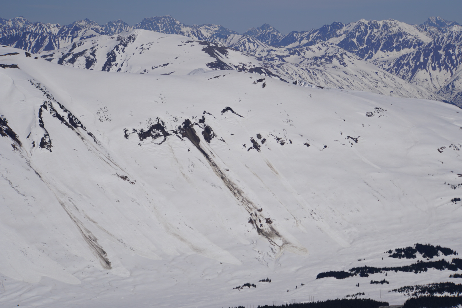
Glide cracks and two older glide avalanches seen on the front (road) side of Seattle Ridge. 4.26.21. George Creighton.


Older glide avalanche on the southern side of Tincan Ridge. 4.26.21. George Creighton.

Weather
Tue, April 27th, 2021

Yesterday:  Sunny skies with light easterly ridgetop winds (5-10mph) were over the region. Temperatures rose from near 30F in valley bottoms to 55+F through the day, while ridgetops climbed from ~35-40F to the mid 40’sF.

Today:  One last full sunny day is expected today as the high pressure ridge over us breaks down to allow for moisture to move in later this week. Temperatures look to be a hair cooler today with high’s near 40F along ridgetops and in the 50’sF in valley bottoms. Ridgetop winds should remain light from the east, 5-10mph.

Tomorrow:  Clouds are forecast to begin moving over the the region tomorrow afternoon with a chance for a little rain/snow on Thursday. Ridgetop winds will remain easterly tomorrow and increase into the 10-20mph range. Temperatures should stay on the cooler side with highs along the ridgelines in the mid 30’sF and mid 40’s in valley bottoms. It’s looking like a chance snow could fall as low as 1,000′ this weekend as a more active and moist weather pattern sets in.

PRECIPITATION 24-hour data (6am – 6am)

Temp Avg (F) Snow (in) Water (in) Snow Depth (in)
Center Ridge (1880′) 41 0 0 91
Summit Lake (1400′) 42 0 0 29
Alyeska Mid (1700′) 43 0 0 102

RIDGETOP 24-hour data (6am – 6am)

Temp Avg (F) Wind Dir Wind Avg (mph) Wind Gust (mph)
Sunburst (3812′) 36 NE 8 21
Seattle Ridge (2400′) 40 SE 7 15
Observations
Recent Observations for Turnagain Pass
Date Region Location
10/27/24 Turnagain Observation: Tincan
10/21/24 Turnagain Observation: Turnagain Pass Road Observation
10/19/24 Turnagain Observation: Tincan – Below Todds Run
10/18/24 Turnagain Observation: Taylor Pass
10/15/24 Turnagain Observation: Tincan Common
10/14/24 Turnagain Avalanche: Tincan
05/13/24 Turnagain Observation: Eddie’s, Sunburst, Seattle, Cornbiscuit, Pete’s South
05/13/24 Turnagain Observation: Turnagain Pass non-motorized side
05/12/24 Turnagain Observation: Warm up Bowl
05/07/24 Turnagain Observation: Turnagain Pass Wet Slabs
Riding Areas

The riding areas page has moved. Please click here & update your bookmarks.


Subscribe to Turnagain Pass
Avalanche Forecast by Email

This is a general backcountry avalanche advisory issued for Turnagain Arm with Turnagain Pass as the core advisory area. This advisory does not apply to highways, railroads or operating ski areas.