Turnagain Pass RSS

Archives
ARCHIVED - Forecasts expire after 24 hours.
Issued
Tue, April 25th, 2023 - 7:00AM
Expires
Wed, April 26th, 2023 - 7:00AM
Forecaster
Andrew Schauer
Avalanche risk The Bottom Line

The avalanche danger is expected to rise to CONSIDERABLE above 2500′ as strong winds and sustained snowfall pick up this afternoon. Human triggered avalanches a foot deep or deeper will become likely, with natural avalanches possible. The most dangerous conditions will be found on wind-loaded slopes. Be on the lookout for increasing danger today through tomorrow, and avoid steep slopes as the weather gets more intense. The danger will be MODERATE below 2500′, where winds and precipitation will be less intense, but human-triggered avalanches failing in the new snow will still be possible.

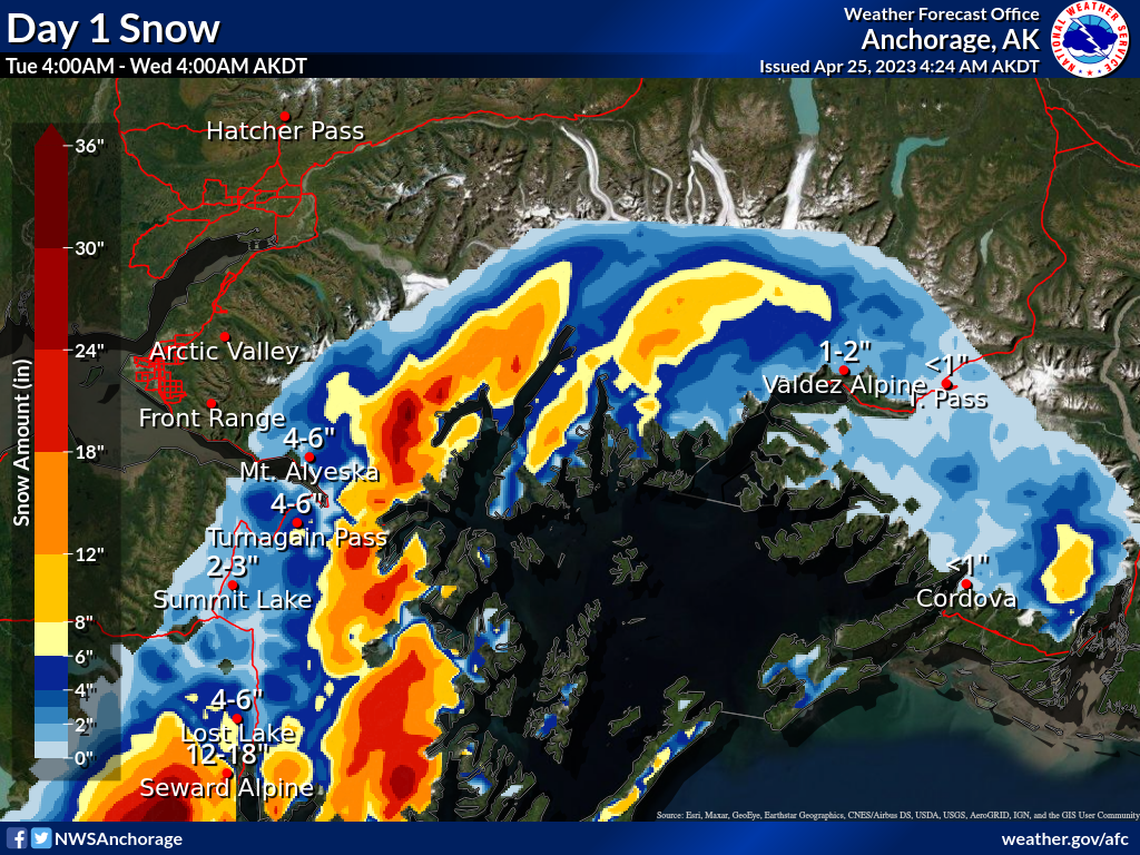
PORTAGE/PLACER: These areas are expected to see 12-18″ snow during this round of precipitation. This will make for larger avalanches that could impact popular hiking trails at lower elevations.

*WEDNESDAY AVALANCHE OUTLOOK: This round of active weather is expected to continue through tonight, and will make for dangerous avalanche conditions into tomorrow. We will issue our next forecast Thursday, April 26.


Special Announcements

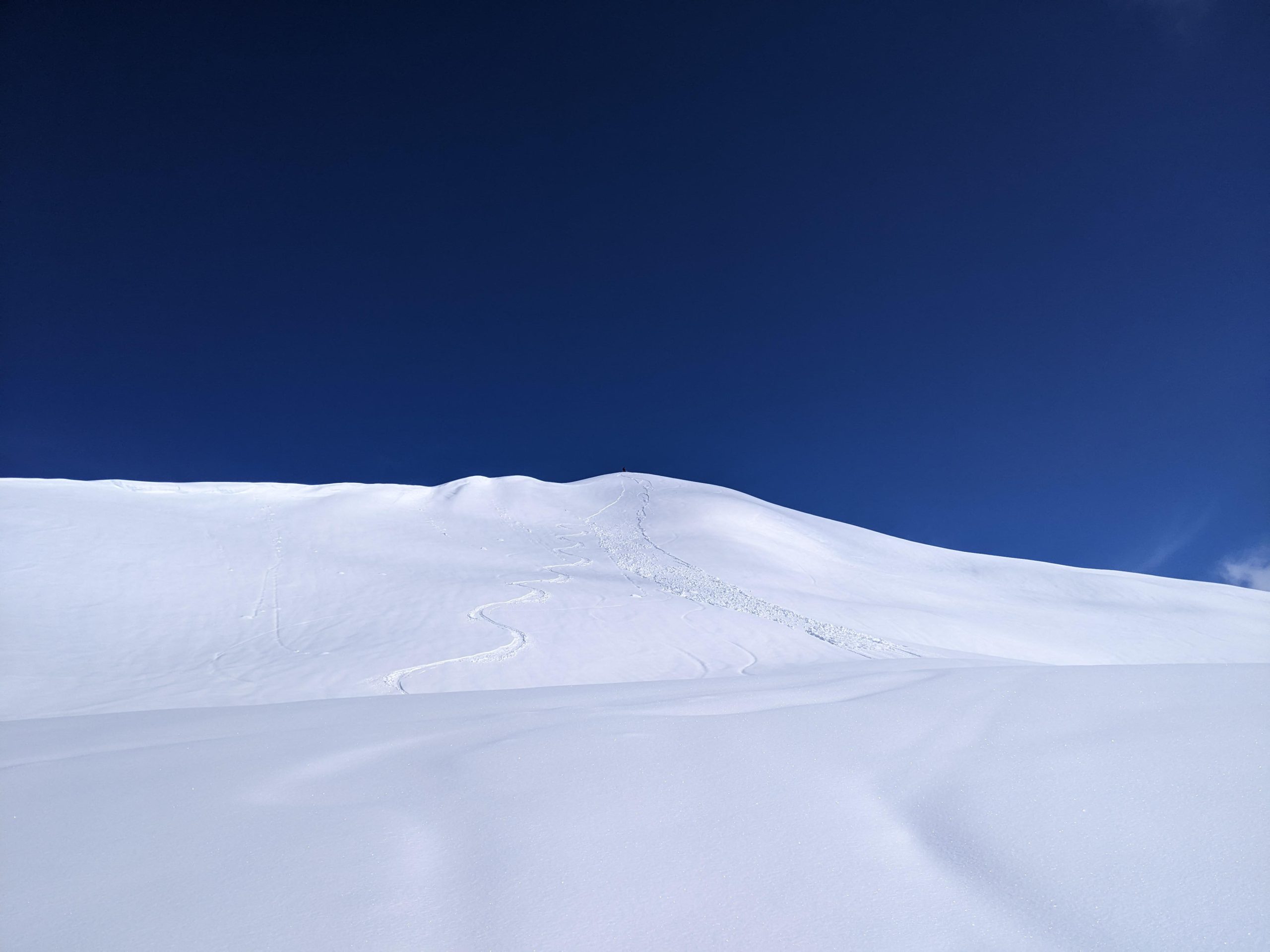
Chugach State Park: We’ve received multiple reports of a wet snowpack in the CSP, that may be primed for a big wet slab avalanche cycle. The exact timing for this type of avalanche is hard to predict, but signs are pointing towards increased likelihood for wet slab activity.

End of Season Operations:  We will be issuing forecasts 4 days/week (Tuesday, Thursday, Saturday, Sunday) until April 30th. If conditions warrant, updates will be posted in early May.

Tue, April 25th, 2023
Alpine
Above 2,500'
3 - Considerable
Avalanche risk
Treeline
1,000'-2,500'
2 - Moderate
Avalanche risk
Below Treeline
Below 1,000'
2 - Moderate
Avalanche risk
0 - No Rating
1 - Low
2 - Moderate
3 - Considerable
4 - High
5 - Extreme
Avalanche risk Avalanche risk Avalanche risk Avalanche risk Avalanche risk
Travel Advice Generally safe avalanche conditions. Watch for unstable snow on isolated terrain features. Heightened avalanche conditions on specific terrain features. Evaluate snow and terrain carefully; identify features of concern. Dangerous avalanche conditions. Careful snowpack evaluation, cautious route-finding, and conservative decision-making essential. Very dangerous avalanche conditions. Travel in avalanche terrain not recommended. Extraordinarily dangerous avalanche conditions. Avoid all avalanche terrain.
Likelihood of Avalanches Natural and human-triggered avalanches unlikely. Natural avalanches unlikely; human-triggered avalanches possible. Natural avalanches possible; human-triggered avalanches likely. Natural avalanches likely; human-triggered avalanches very likely. Natural and human-triggered avalanches certain.
Avalanche Size and Distribution Small avalanches in isolated areas or extreme terrain. Small avalanches in specific areas; or large avalanches in isolated areas. Small avalanches in many areas; or large avalanches in specific areas; or very large avalanches in isolated areas. Large avalanches in many areas; or very large avalanches in specific areas. Very large avalanches in many areas.
Recent Avalanches

There were multiple natural and human-triggered avalanches yesterday. One skier got carried a short distance by their sluff on Tincan, but was able to get off of the  moving debris. Over on Sunburst, I was surprised by the large volume of a dry loose avalanche I intentionally triggered on the north side of the ridgeline (details here). All of this goes to show that Sunday’s new snow is poorly bonded to the older surfaces.

Smaller skier-triggered loose snow avalanche that carried a skier a short distance. The skier was able to get off the moving debris. Shared anonymously, 04.24.2023

This dry loose avalanche was intentionally triggered but surprisingly big. It ran about 1000 vertical feet and was an estimated 150′ wide at the debris pile. 04.24.2023

Avalanche Problem 1
  • Storm Slabs
    Storm Slabs
  • Aspect/Elevation
  • Certain
    Very Likely
    Likely
    Possible
    Unlikely
    Likelihood
  • Historic (D4-5)
    Very Large (D3)
    Large (D2)
    Small (D1)
    Size
Storm Slabs
Storm Slab avalanches are the release of a cohesive layer (a slab) of new snow that breaks within new snow or on the old snow surface. Storm-slabs typically last between a few hours and few days (following snowfall). Storm-slabs that form over a persistent weak layer (surface hoar, depth hoar, or near-surface facets) may be termed Persistent Slabs or may develop into Persistent Slabs.

Aspect/Elevation of the Avalanche Problem
Specialists develop a graphic representation of the potential distribution of a particular avalanche problem across the topography. This aspect/elevation rose is used to indicate where the particular avalanche problem is thought to exist on all elevation aspects. Areas where the avalanche problem is thought to exist are colored grey, and it is less likely to be encountered in areas colored white.

Likelihood of Avalanches
Terms such as "unlikely", "likely", and "certain" are used to define the scale, with the chance of triggering or observing avalanches increasing as we move up the scale. For our purposes, "Unlikely" means that few avalanches could be triggered in avalanche terrain and natural avalanches are not expected. "Certain" means that humans will be able to trigger avalanches on many slopes, and natural avalanches are expected.

Size of Avalanches
Avalanche size is defined by the largest potential avalanche, or expected range of sizes related to the problem in question. Assigned size is a qualitative estimate based on the destructive classification system and requires specialists to estimate the harm avalanches may cause to hypothetical objects located in the avalanche track (AAA 2016, CAA 2014). Under this schema, "Small" avalanches are not large enough to bury humans and are relatively harmless unless they carry people over cliffs or through trees or rocks. Moving up the scale, avalanches become "Large" enough to bury, injure, or kill people. "Very Large" avalanches may bury or destroy vehicles or houses, and "Historic" avalanches are massive events capable of altering the landscape.

Signal Word Size (D scale) Simple Descriptor
Small 1 Unlikely to bury a person
Large 2 Can bury a person
Very Large 3 Can destroy a house
Historic 4 & 5 Can destroy part or all of a village
More info at Avalanche.org

The weather is ramping up today, starting with strong winds and a few inches of snow later in the day. Although we are only expecting 1-3″ during the day, the combination of new snow, and strong winds on top of the 4-6″ snow from Sunday will make for dangerous avalanche conditions later in the day. Yesterday it was obvious that the new snow was bonding poorly to old surfaces, with loose snow avalanches picking up quite a bit of volume and running long distances. These older surfaces were mostly crusts, with the exception of upper elevation northerly aspects harboring near-surface facets. Either way, this round of snow and wind will make it likely a person can trigger an avalanche a foot deep or deeper, failing at that new/old interface, and natural avalanches will be possible as the winds make fresh slabs during the day today.

Be on the lookout for increasing danger as the weather ramps up through the day. The most dangerous slopes will be the ones that are getting loaded by the strong winds today, which will be most likely near ridgelines, convexities, and steep gullies. As the snow starts to fall later in the day through tonight, avalanches failing on sheltered slopes will start to get a little bit bigger and easier to trigger. Loose Snow Avalanches will be likely on all aspects, and will likely be getting big enough to bury a person as snowfall continues.

This is the first of what is looking to be multiple rounds of storms this week. We are expecting to see elevated avalanche danger into the weekend as snow continues to fall, and we may see rain into the upper elevations later in the week. The forecast has been tricky to nail down, so be sure to stay tuned as we track the conditions.

Winter is hanging in there… It’s looking like we should see 4-6″ snow in Girdwood and Turnagain Pass, and up to 12-18″ near Portage and Placer by tomorrow morning. Graphic courtesy of NWS Anchorage. 04.25.2023

Avalanche Problem 2
  • Deep Persistent Slabs
    Deep Persistent Slabs
  • Aspect/Elevation
  • Certain
    Very Likely
    Likely
    Possible
    Unlikely
    Likelihood
  • Historic (D4-5)
    Very Large (D3)
    Large (D2)
    Small (D1)
    Size
Deep Persistent Slabs
Deep Persistent Slab avalanches are the release of a thick cohesive layer of hard snow (a slab), when the bond breaks between the slab and an underlying persistent weak layer deep in the snowpack. The most common persistent weak layers involved in deep, persistent slabs are depth hoar or facets surrounding a deeply buried crust. Deep Persistent Slabs are typically hard to trigger, are very destructive and dangerous due to the large mass of snow involved, and can persist for months once developed. They are often triggered from areas where the snow is shallow and weak, and are particularly difficult to forecast for and manage.

Aspect/Elevation of the Avalanche Problem
Specialists develop a graphic representation of the potential distribution of a particular avalanche problem across the topography. This aspect/elevation rose is used to indicate where the particular avalanche problem is thought to exist on all elevation aspects. Areas where the avalanche problem is thought to exist are colored grey, and it is less likely to be encountered in areas colored white.

Likelihood of Avalanches
Terms such as "unlikely", "likely", and "certain" are used to define the scale, with the chance of triggering or observing avalanches increasing as we move up the scale. For our purposes, "Unlikely" means that few avalanches could be triggered in avalanche terrain and natural avalanches are not expected. "Certain" means that humans will be able to trigger avalanches on many slopes, and natural avalanches are expected.

Size of Avalanches
Avalanche size is defined by the largest potential avalanche, or expected range of sizes related to the problem in question. Assigned size is a qualitative estimate based on the destructive classification system and requires specialists to estimate the harm avalanches may cause to hypothetical objects located in the avalanche track (AAA 2016, CAA 2014). Under this schema, "Small" avalanches are not large enough to bury humans and are relatively harmless unless they carry people over cliffs or through trees or rocks. Moving up the scale, avalanches become "Large" enough to bury, injure, or kill people. "Very Large" avalanches may bury or destroy vehicles or houses, and "Historic" avalanches are massive events capable of altering the landscape.

Signal Word Size (D scale) Simple Descriptor
Small 1 Unlikely to bury a person
Large 2 Can bury a person
Very Large 3 Can destroy a house
Historic 4 & 5 Can destroy part or all of a village
More info at Avalanche.org

We still cannot rule out the possibility of triggering a large avalanche on weak snow buried in the middle of the snowpack. The chances of triggering an avalanche like this are small, but the consequences are severe. The most recent avalanche triggered on a deeper weak layer was almost a week ago, but this is just the latest in a string of activity that has lasted for over a month now. This layer is difficult, if not impossible, to assess. The best way to truly manage this problem is by avoiding big, consequential terrain. Consider the consequences of getting taken for a ride before trying to get out into steeper slopes.

Weather
Tue, April 25th, 2023

Yesterday: Mostly cloudy skies in the morning cleared for mostly sunny skies by mid-afternoon. Winds were light out of the east around 5 mph for most of the day, with high temperatures reaching the low 30’s to low 40’s F. The coldest temperatures of the day were yesterday morning, with temperatures in the upper teens to mid 20’s F. Overnight lows last night were in the low 20’s at upper elevations and just above freezing at lower elevations. We did not record any precipitation last night.

Today: Things are going to pick up today, starting with winds. We’ve already seen increasing winds, with average speeds around 15-20 mph since last night. Winds are expected to increase to 25-40 mph with gusts of 35-50 mph out of the east during the day. Snowfall should start this afternoon, with 1-3” expected in Girdwood and Turnagain Pass and 4-6” near Portage and Placer before sunset. The rain line should stay around 500’ for this round of precipitation.

Tomorrow: Snowfall is expected to continue tonight, with another 2-4” precipitation tonight near Girdwood and Turnagain Pass, and 6-10” near Portage and Placer. This round of precipitation should wrap up by tomorrow morning. Rain levels will rise as precipitation tapers off, and we may see some rain up to 1000’. Easterly winds should back down early tomorrow morning, before ramping up again later in the day. Expect to see average wind speeds around 5-10 mph tomorrow morning and 10-20 mph by tomorrow evening. Skies should be partly to mostly cloudy during the day tomorrow.

PRECIPITATION 24-hour data (6am – 6am)

Temp Avg (F) Snow (in) Water (in) Snow Depth (in)
Center Ridge (1880′) 31 0 0 85
Summit Lake (1400′) 30 0 0 38
Alyeska Mid (1700′) 32 0 0 74
Bear Valley – Portage (132′) 35 0 0

RIDGETOP 24-hour data (6am – 6am)

Temp Avg (F) Wind Dir Wind Avg (mph) Wind Gust (mph)
Sunburst (3812′) 23 ENE 8 41
Seattle Ridge (2400′) 26 SE 8 25
Observations
Recent Observations for Turnagain Pass
Date Region Location
04/16/24 Turnagain Observation: Cornbiscuit
04/15/24 Turnagain Observation: Taylor Pass
04/15/24 Turnagain Observation: Seward Highway – Tern Lake to Portage
04/14/24 Turnagain Observation: Sunburst
04/14/24 Turnagain Observation: Turnagain Pass Snomo
04/13/24 Turnagain Observation: Spokane Creek
04/11/24 Turnagain Observation: Tincan
04/10/24 Turnagain Avalanche: Seattle Ridge
04/10/24 Turnagain Observation: Cornbiscuit South Face
04/10/24 Turnagain Avalanche: Tincan
Riding Areas

The riding areas page has moved. Please click here & update your bookmarks.


Subscribe to Turnagain Pass
Avalanche Forecast by Email

This is a general backcountry avalanche advisory issued for Turnagain Arm with Turnagain Pass as the core advisory area. This advisory does not apply to highways, railroads or operating ski areas.