Turnagain Pass Avalanche Forecast RSS

Archives
ARCHIVED FORECAST - All forecasts expire after 24 hours from the posting date/time.
Issued
Thu, April 8th, 2021 - 7:00AM
Expires
Fri, April 9th, 2021 - 7:00AM
Forecaster
Aleph Johnston-Bloom
Avalanche risk The Bottom Line

The avalanche danger will rise to CONSIDERABLE above 1000′. Increasing NW winds today, combined with a little bit of new snow, will make triggering a wind slab in mid and upper elevation terrain likely. These may step down to buried weak layers, creating a larger avalanche. Natural avalanches and cornice falls will be possible. Pay attention to changing conditions. Watch for blowing snow, shooting cracks and recent avalanches. Cautious route-finding and conservative decision-making are essential.

PORTAGE VALLEY and PLACER VALLEY: There is potential for avalanche debris, from a slide occurring above, to run to low elevation terrain. Avoiding gullies and runout zones is recommended. This is not a good afternoon to hike to Byron Glacier.

SUMMIT LAKE/SNUG HARBOR/LOST LAKE/SEWARD: The northwest winds are forecast to be strongest in these areas. Watch for blowing snow, signs of instability and pay careful attention to terrain selection. As winds increase natural avalanches will become likely.

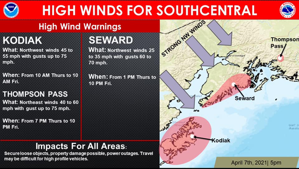
The National Weather Service has issued a High Wind Warning in effect from 1 pm today to 10 pm Friday.

Special Announcements

Hatcher Pass:  The road to Hatcher Pass remains closed at MP10. For updates go to AK 511 and follow AKDOT&PF on social media. Click HERE for an ADN article about the closure. For the Hatcher Pass Thursday Conditions Summary go to hpavalanche.org.

Thanks to our sponsors!
Thu, April 8th, 2021
Alpine
Above 2,500'
Considerable (3)
Avalanche risk
Treeline
1,000'-2,500'
Considerable (3)
Avalanche risk
Below Treeline
Below 1,000'
Moderate (2)
Avalanche risk
Alpine
Above 2,500'
Avalanche risk
Considerable (3)
Treeline
1,000'-2,500'
Avalanche risk
Considerable (3)
Below Treeline
Below 1,000'
Avalanche risk
Moderate (2)
Danger Scale:
No Rating (0)
Low (1)
Moderate (2)
Considerable (3)
High (4)
Extreme (5)
Avalanche Problem 1
  • Wind Slabs
    Wind Slabs
  • Almost Certain
    Very Likely
    Likely
    Possible
    Unlikely
    Likelihood
  • Historic (D4-5)
    Very Large (D3)
    Large (D2)
    Small (D1)
    Size
Wind Slabs
Wind Slab avalanches are the release of a cohesive layer of snow (a slab) formed by the wind. Wind typically transports snow from the upwind sides of terrain features and deposits snow on the downwind side. Wind slabs are often smooth and rounded and sometimes sound hollow, and can range from soft to hard. Wind slabs that form over a persistent weak layer (surface hoar, depth hoar, or near-surface facets) may be termed Persistent Slabs or may develop into Persistent Slabs.

Likelihood of Avalanches
Terms such as "unlikely", "likely", and "certain" are used to define the scale, with the chance of triggering or observing avalanches increasing as we move up the scale. For our purposes, "Unlikely" means that few avalanches could be triggered in avalanche terrain and natural avalanches are not expected. "Certain" means that humans will be able to trigger avalanches on many slopes, and natural avalanches are expected.

Size of Avalanches
Avalanche size is defined by the largest potential avalanche, or expected range of sizes related to the problem in question. Assigned size is a qualitative estimate based on the destructive classification system and requires specialists to estimate the harm avalanches may cause to hypothetical objects located in the avalanche track (AAA 2016, CAA 2014). Under this schema, "Small" avalanches are not large enough to bury humans and are relatively harmless unless they carry people over cliffs or through trees or rocks. Moving up the scale, avalanches become "Large" enough to bury, injure, or kill people. "Very Large" avalanches may bury or destroy vehicles or houses, and "Historic" avalanches are massive events capable of altering the landscape.

Signal Word Size (D scale) Simple Descriptor
Small 1 Unlikely to bury a person
Large 2 Can bury a person
Very Large 3 Can destroy a house
Historic 4 & 5 Can destroy part or all of a village
More info at Avalanche.org

If you have been out the past couple days enjoying the wind board and melt-freeze crusts, you may be thinking, “Snow available for transport??? No way!” However, with an inch overnight and forecast winds strong enough to erode into old snow, don’t be surprised by fresh wind slabs forming later today. Triggering a wind slab also has the potential to step down to weak layers buried in the top 3′ of the snowpack and create a larger avalanche (more in Problem 2).

With the little bit of snowfall last night/early this morning the winds were easterly 10-20 mph with gusts into the 30s. The winds will shift to the northwest this morning and blow 20-30 mph with gusts into the 40s today. Expect winds to increase throughout the afternoon and into tomorrow. Winds may blow into the 70s in the mountains closer to Seward overnight. As we have mentioned before, this wind flow direction (from the NW) is tricky for Turnagain Pass. It can funnel through the Pass from the south and load north aspects on the non-motorized side, while at the same time load the SE face of Seattle Ridge.  This wind pattern also increases through channeled terrain and can be more pronounced in Crow Pass and Portage. The mountains from Summit Lake south to Seward are forecast to see the most wind and the snowpack has more sensitive buried weak layers. Although these areas are out of the CNFAIC forecast zone we want to highlight the potential for natural avalanches to become likely as the winds build.

What to look for if you’re headed out today:

  • Areas with current wind-loading (Northwest winds should blow all day), natural avalanches and cornice falls are possible. Pay attention to what terrain is above you.
  • Slabs lower on slopes from cross-loading, especially with the winds funneling through Turnagain pass from the south.
  • Stiff snow over softer snow (punchy snow), does it feel slabby?
  • Cracks shooting from your skis or machine.
  • Avoid cornices. They may be tender and easy to trigger.

Loose snow avalanches: Steep north facing slopes that are sheltered from the wind could have loose snow sitting on top of firm surfaces. Triggering dry loose avalanches (sluffs) in that terrain is possible today and wind loading could trigger natural sluffs.

Avalanche Problem 2
  • Persistent Slabs
    Persistent Slabs
  • Almost Certain
    Very Likely
    Likely
    Possible
    Unlikely
    Likelihood
  • Historic (D4-5)
    Very Large (D3)
    Large (D2)
    Small (D1)
    Size
Persistent Slabs
Persistent Slab avalanches are the release of a cohesive layer of snow (a slab) in the middle to upper snowpack, when the bond to an underlying persistent weak layer breaks. Persistent layers include: surface hoar, depth hoar, near-surface facets, or faceted snow. Persistent weak layers can continue to produce avalanches for days, weeks or even months, making them especially dangerous and tricky. As additional snow and wind events build a thicker slab on top of the persistent weak layer, this avalanche problem may develop into a Deep Persistent Slab.

Likelihood of Avalanches
Terms such as "unlikely", "likely", and "certain" are used to define the scale, with the chance of triggering or observing avalanches increasing as we move up the scale. For our purposes, "Unlikely" means that few avalanches could be triggered in avalanche terrain and natural avalanches are not expected. "Certain" means that humans will be able to trigger avalanches on many slopes, and natural avalanches are expected.

Size of Avalanches
Avalanche size is defined by the largest potential avalanche, or expected range of sizes related to the problem in question. Assigned size is a qualitative estimate based on the destructive classification system and requires specialists to estimate the harm avalanches may cause to hypothetical objects located in the avalanche track (AAA 2016, CAA 2014). Under this schema, "Small" avalanches are not large enough to bury humans and are relatively harmless unless they carry people over cliffs or through trees or rocks. Moving up the scale, avalanches become "Large" enough to bury, injure, or kill people. "Very Large" avalanches may bury or destroy vehicles or houses, and "Historic" avalanches are massive events capable of altering the landscape.

Signal Word Size (D scale) Simple Descriptor
Small 1 Unlikely to bury a person
Large 2 Can bury a person
Very Large 3 Can destroy a house
Historic 4 & 5 Can destroy part or all of a village
More info at Avalanche.org

We are still talking about a few layers of facets and buried surface hoar in the top 3′ of the snowpack. Shaded aspects, the ones that are most inviting with dry snow, are the most suspect place to trigger these now, as southerly slopes have various sun crusts. We are always concerned about something adding more load and tipping the balance causing one of these deeper layers to fail. With the winds forecast today this is on our radar. Winds channeled from the south could overload northerly aspects. Triggering a shallow wind slab or a cornice fall could potentially step down to a buried weak layer and cause a larger avalanche.

Knowing these layers are there, listening/feeling for whumpfing and watching for any other signs of instability are good things to keep in mind. As always, use good travel protocol, and consider the consequences if an avalanche does occur. Don’t forget natural avalanches will become possible today as wind loading increases.

Weather
Thu, April 8th, 2021

Yesterday: Skies started out clear. Clouds increased throughout the day becoming overcast in the late afternoon. Winds were light and westerly. Highs were in the teens in the alpine and in the low 30°Fs near sea level. There was very light snow overnight and the winds shifted to the east blowing 10-20 mph gusting into the 30s.  Low temperatures were in the teens to mid 20°Fs.

Today: Skies will be cloudy with a chance of light snow in the morning and decreasing clouds in the afternoon. Winds will shift to the west/northwest this morning and increase throughout the day into tomorrow. Winds are forecast to blow 15-35 mph with gusts into the 40s. Temperatures will be in the teens and 20°Fs today and drop as cold air moves in. Skies will be mostly clear overnight. Temperatures will be in the single digits to as low as the negative teens with the wind chill. Northwest winds will continue 25-45 mph with gust into the 50s.

Tomorrow: Clear skies with temperatures in the teens and single digits. Northwest winds continue 15-25 mph with gusts into the 30s and 40s, decreasing in the evening. Cold temperatures and mostly clear skies continue Saturday with a change in weather pattern expected Saturday night. From the NWS: Looking ahead, a storm system with a deep fetch of tropical moisture is expected to arrive late Saturday into Sunday. Stay tuned!

PRECIPITATION 24-hour data (6am – 6am)

Temp Avg (F) Snow (in) Water (in) Snow Depth (in)
Center Ridge (1880′) 23 1 0.1 108
Summit Lake (1400′) 22 1 0.1 48
Alyeska Mid (1700′) 22 1 0.06 118

RIDGETOP 24-hour data (6am – 6am)

Temp Avg (F) Wind Dir Wind Avg (mph) Wind Gust (mph)
Sunburst (3812′) 11 W-NE* 10 40
Seattle Ridge (2400′) 16 W-E* 8 27

*Wind shift in the late afternoon yesterday. Expect another shift this morning.

Observations
Recent Observations for Turnagain Pass
Date Region Location
05/22/23 Turnagain Avalanche: Tincan
05/12/23 Turnagain Avalanche: Tincan, Sunburst, Magnum, Cornbiscuit
05/07/23 Turnagain Observation: Tincan – Bear Tracks
05/05/23 Turnagain Observation: Seattle Ridge
05/02/23 Turnagain Observation: Cornbiscuit
05/02/23 Turnagain Observation: Seward Hwy Turnagain Pass
04/30/23 Turnagain Observation: Magnum
04/29/23 Turnagain Observation: Tincan
04/28/23 Turnagain Avalanche: Taylor Pass/Pastoral
04/28/23 Turnagain Avalanche: Tincan
Riding Areas
Updated Thu, June 01st, 2023

Status of riding areas across the Chugach NF is managed by the Glacier and Seward Ranger Districts, not avalanche center staff. Riding area information is posted as a public service to our users and updated based on snow depth and snow density to prevent resource damage at trailhead locations. Riding area questions contact: mailroom_r10_chugach@fs.fed.us

Area Status Weather & Riding Conditions
Glacier District
Johnson Pass
Closed
Closed May 15.
Placer River
Closed
Closed May 15.
Skookum Drainage
Closed
Will close to motorized use on April 1, 2023 per the National Forest Plan.
Turnagain Pass
Closed
Will close on June 1.
Twentymile
Closed
Scheduled closure May 1.
Seward District
Carter Lake
Closed
Scheduled closure May 1.
Lost Lake Trail
Closed
Scheduled closure May 1.
Primrose Trail
Closed
Scheduled closure May 1.
Resurrection Pass Trail
Closed
Closed to motorized use for the 2022/23 winter season per Forest Plan. Open next season.
Snug Harbor
Closed
Extended opening until May 15.
South Fork Snow River Corridor
Closed
Scheduled closure May 1.
Summit Lake
Closed
Scheduled closure May 1.

Subscribe to Turnagain Pass
Avalanche Forecast by Email

This is a general backcountry avalanche advisory issued for Turnagain Arm with Turnagain Pass as the core advisory area. This advisory does not apply to highways, railroads or operating ski areas.